November 21 , 2025.
Chile / Argentina , Planchon – Peteroa :
Seismology
The seismic activity of the period was characterized by the recording of:
35 VT-type seismic events, associated with rock fracturing (volcano-tectonics). The strongest earthquake, with a local magnitude (ML) of 1.5, was located 19.8 km east-southeast of the volcanic edifice, at a depth of 3.3 km.
1,222 LP-type seismic events, associated with fluid dynamics within the volcanic system (long period). The amplitude of the largest earthquake, measured by the reduced displacement parameter (DR), was 45 cm² (see REAV https://rnvv.sernageomin.cl/complejo-volcanico-planchon-peteroa/, November 13, 10:10 a.m. local time).
2,504 TR-type seismic events, associated with sustained fluid dynamics within the volcanic system (TRemor), were recorded. The largest earthquake, measured using the reduced displacement parameter (DR), had a magnitude of 18 cm².
Fluid Geochemistry
Five anomalies in atmospheric sulfur dioxide (SO₂) emissions were detected near the volcanic complex, according to data published by GeoService. Similarly, the Mounts platform recorded a peak emission mass of 1,437 tonnes for the period on November 6, consistent with increased surface activity, incandescence, and pyroclastic loading, possibly linked to a more intense magmatic component during this period.
Satellite Thermal Anomalies
Based on the analytical processing of images from the Sentinel-2-L2A satellite, no thermal radiation anomalies were recorded between November 1 and 15. In addition, the MIROVA (Observation of Volcanic Activity in the Mid-Infrared) sensors recorded a thermal anomaly of 1 MW in VIIRS 750 and 7 anomalous values in VIIRS 350, with a maximum of 0.6 MW on November 14, while MODIS did not detect any higher radiative power values.
Geodesy
Geodetic monitoring conducted during this period, using data from two GNSS stations and satellite radar imagery, indicates that:
No significant variation in horizontal or vertical components was observed, which could have indicated deep intrusions of material.
Radar interferometry (InSAR) of Sentinel-1A images revealed no deformation around the complex.
Surveillance Cameras
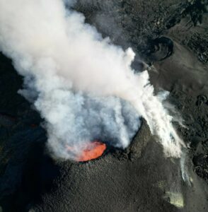
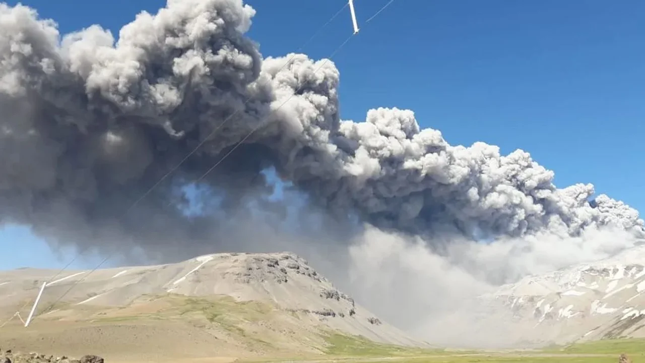
Images from fixed cameras recorded continuous degassing and recurring pyroclastic emissions from the Southwest Crater, with a maximum column height of 1,860 m above the crater rim on November 13. Other events characterized by a high pyroclastic load and moderate explosivity were also observed, notably on November 2, 6, 7, and 9, when column heights exceeded 1 km above the crater and, in some cases, ballistic projectiles were found within a 500 m radius of the emission center. Furthermore, incandescence phenomena associated with explosive activity and high-temperature degassing were observed on at least four occasions.
Satellite geomorphological analysis:
Photographic interpretation of false- and true-color satellite images from SkySat Collect, PlanetScope, and Sentinel-2LA led to the following conclusions:
– The pyroclastic material emissions generated a fallback deposit extending up to 6.7 km to the east-southeast, 15 km to the south, and 4 km to the north. The last two directions are located primarily within the national territory, while the deposits to the east and southeast are mainly within Argentine territory. The maximum ranges are associated with the events observed on November 9 and 13 by surveillance cameras. Furthermore, in the SkySat image from November 15, impact craters and blocks associated with ballistic projectile emissions were identified within a 230-meter radius of the center of the southwest crater.
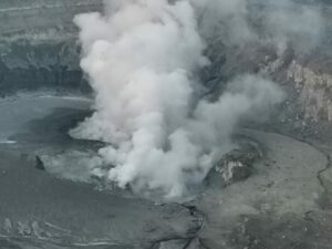
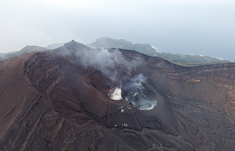
The activity visible in satellite imagery is concentrated exclusively in the Southwest Crater, whose crater lake is invisible due to constant emissions of gas and/or pyroclastic material. No morphological changes indicating pyroclastic material emissions or other forms of volcanic activity have been detected in the vicinity of the craters. However, an increase in the surface area of the lake in the North Crater has been observed, rising from 6,795 to 9,661 m² over the past two weeks. No signs of activation of other areas by direct volcanic activity have been observed. Nevertheless, in areas adjacent to the active craters, an acceleration of changes in snow cover has been observed, due to the relative increase in temperatures and tephra deposition from recent volcanic activity.
Source : Sernageomin
Photos : Segemar , canal 13 san juan.
Japan , Suwanosejima :
The Japan Meteorological Agency (JMA) reported that eruptive activity at Suwanosejima’s Ontake Crater continued during 10-14 November. Incandescence was observed nightly in webcam images and ashfall was reported in Toshima Village (3.5 km SSW). An eruptive event at 21h07 on 10 November produced an ash plume that rose 1 km above the crater rim and drifted SW. Large blocks were ejected 200 m from the vent. At 21h57 on 16 November an eruptive event produced an ash plume that rose 1.5 km above the crater rim and drifted W. The Alert Level remained at 2 (the second level on a five-level scale) and the public was warned to be cautious within 1.5 km of the crater.
The 8-km-long island of Suwanosejima in the northern Ryukyu Islands consists of an andesitic stratovolcano with two active summit craters. The summit is truncated by a large breached crater extending to the sea on the E flank that was formed by edifice collapse. One of Japan’s most frequently active volcanoes, it was in a state of intermittent Strombolian activity from Otake, the NE summit crater, between 1949 and 1996, after which periods of inactivity lengthened. The largest recorded eruption took place in 1813-14, when thick scoria deposits covered residential areas, and the SW crater produced two lava flows that reached the western coast. At the end of the eruption the summit of Otake collapsed, forming a large debris avalanche and creating an open collapse scarp extending to the eastern coast. The island remained uninhabited for about 70 years after the 1813-1814 eruption. Lava flows reached the eastern coast of the island in 1884. Only about 50 people live on the island.
Sources : Japan Meteorological Agency (JMA) , GVP.
Photo : Auteur inconnu.
Colombia , Galeras :
San Juan de Pasto, November 18, 2025, 5:10 PM
Regarding the monitoring of activity at the Galeras volcano, the Colombian Geological Survey (SGC), an agency under the Ministry of Mines and Energy, reports the following:
During the week of November 11-17, 2025, the main variations in monitored parameters compared to the previous week were as follows:
● A decrease in seismic activity and an increase in energy released were recorded. Seismicity associated with rock fracturing remains predominant.
● Seismicity was primarily located within a 1.1 km radius of the main crater of the Galeras volcano, at depths of less than 3 km. The remaining seismic activity was located within the volcano’s zone of influence, up to 11 km away and 8 km deep. The largest earthquake (magnitude 1.2) was located 0.5 km south-southeast of the crater, at a depth of 2.9 km.
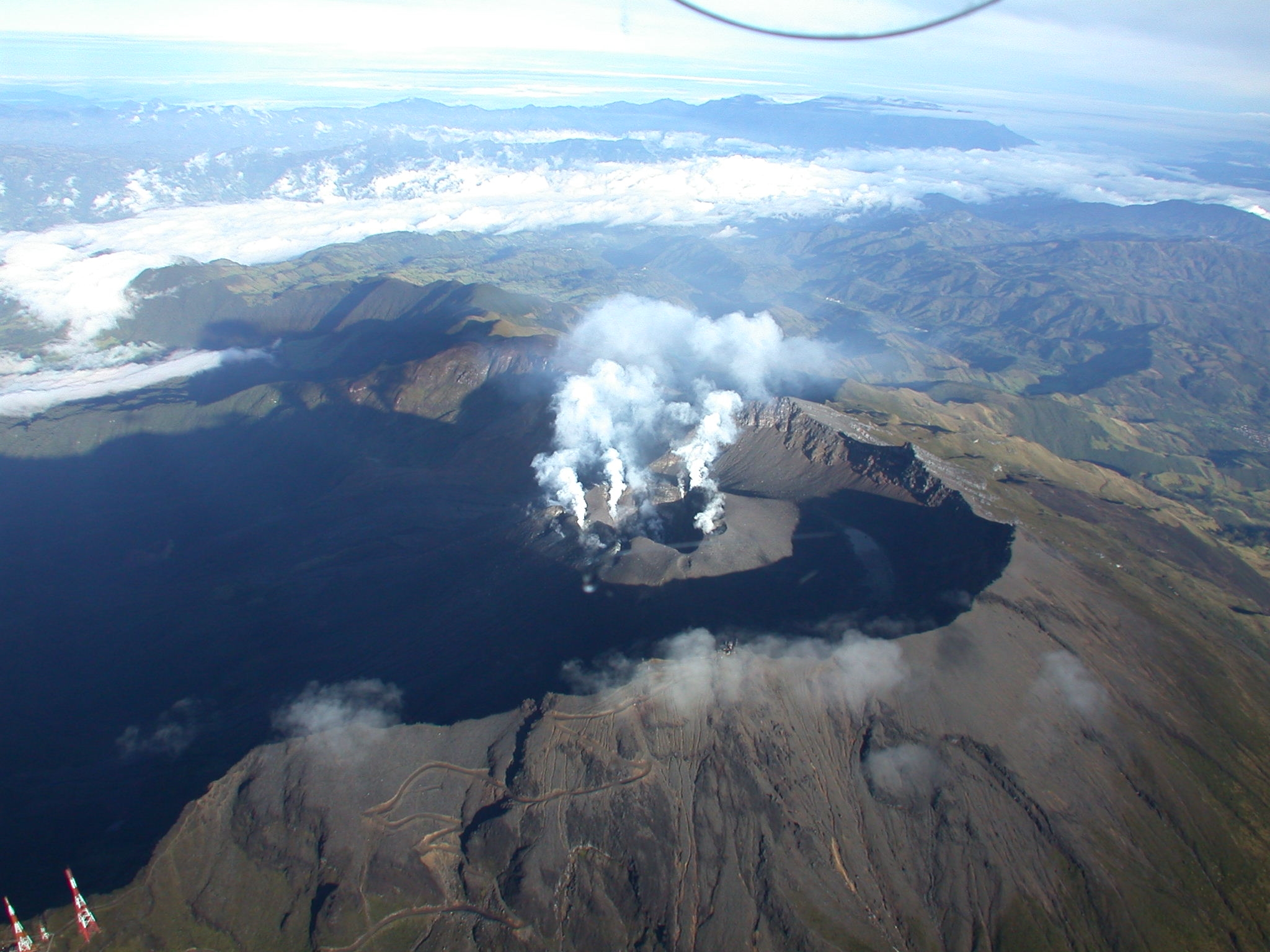
● Despite the weather conditions, low-altitude plumes of white gas were observed, primarily originating from the fumarole fields of El Paisita (North) and Las Chavas (West). The dispersion of these plumes varied depending on wind direction and strength.
● All other volcanic monitoring parameters remained stable.
In light of the above, the Geological Survey of Colombia (SGC) recommends closely monitoring the volcano’s activity through weekly bulletins and other information published on its official channels, as well as following the instructions of local and departmental authorities and the National Unit for Disaster Risk Management (UNGRD).
● Volcanic activity remains at the yellow alert level: Active volcano with changes in the baseline behavior of monitored parameters and other manifestations.
Source et photo : SGC
Hawaii , Kilauea :
HAWAIIAN VOLCANO OBSERVATORY DAILY UPDATE , U.S. Geological Survey
Thursday, November 20, 2025, 9:24 AM HST (Thursday, November 20, 2025, 19:24 UTC)
19°25’16 » N 155°17’13 » W,
Summit Elevation 4091 ft (1247 m)
Current Volcano Alert Level: WATCH
Current Aviation Color Code: ORANGE
Activity Summary:
The Kīlauea summit eruption is paused. Overnight, there was glow from the north and south vents. Inflationary tilt is being recorded by summit tiltmeters. Models suggest that episode 37 could occur between November 21 to November 26.
Summit Observations:
Continuous glow was observed from both vent overnight. Slumping due to gravity was observed earlier this week along the southwest crater rim. Low level, continuous tremor has been recorded since early Tuesday morning.
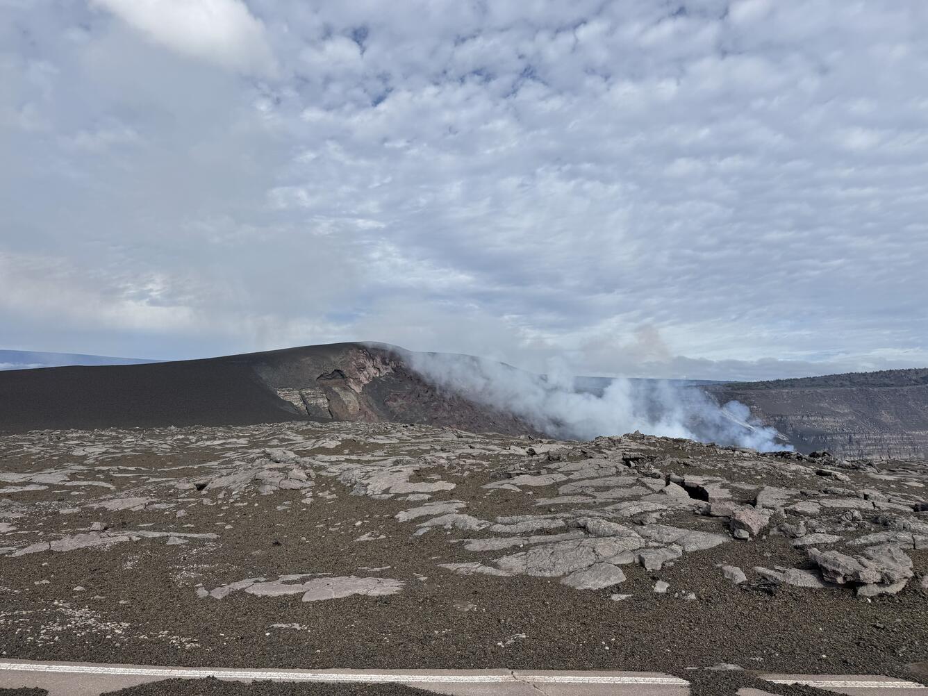
Lava fountains from 36 episodes of the ongoing eruption in Halemaʻumaʻu crater, at the summit of Kīlauea, have built a prominent new puʻu (made up of tephra) perched on the rim of the crater. In the foreground, tephra covers part of Crater Rim Drive in this closed area of Hawaiʻi Volcanoes National Park.
Inflation has slowed in the last 24 hours. UWD recorded less than 1 microradian of inflationary tilt in the past 24 hours with a total of 18.6 microradians recorded since episode 36 ended on November 9.
Plumes of gas are visible from both the south and north vents, and sulfur dioxide (SO2) gas emissions remain at eruption pause levels, typically between 1,200 and 1,500 tonnes per day.
Episode 36 began at approximately 11:15 a.m. HST on November 9 and ended at 4:16 p.m. HST, after erupting for 5 hours. Episode 36 fountains produced just under 11 million cubic yards (about 8 million cubic meters) of lava. The combined average eruption rate was over 600 cubic yards per second (500 cubic meters per second) from the dual fountains. Lava flows from the fountains covered about 80 percent of the floor of Halemaʻumaʻu crater.
Source : HVO
Photo : USGS / N. Kohagura.
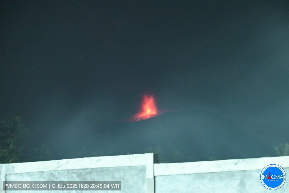
Indonesia , Ibu :
Mount Ibu erupted on Thursday, November 20, 2025, at 8:50 p.m. (local time). An ash column was observed approximately 500 meters above the summit (at an altitude of about 1,825 meters). This ash column was gray and denser towards the southeast. The eruption was recorded by a seismograph with a maximum amplitude of 28 mm and a duration of 51 seconds.
VOLCANO OBSERVATORY NOTICE FOR AVIATION – VONA
Issued : November 20 , 2025
Volcano : Ibu (268030)
Current Aviation Colour Code : ORANGE
Previous Aviation Colour Code : orange
Source : Ibu Volcano Observatory
Notice Number : 2025IBU1139
Volcano Location : N 01 deg 29 min 17 sec E 127 deg 37 min 48 sec
Area : North Maluku, Indonesia
Summit Elevation : 4240 FT (1325 M)
Volcanic Activity Summary :
Eruption with volcanic ash cloud at 11h50 UTC (20h50 local).
Volcanic Cloud Height :
Best estimate of ash-cloud top is around 5840 FT (1825 M) above sea level or 1600 FT (500 M) above summit. May be higher than what can be observed clearly. Source of height data: ground observer.
Other Volcanic Cloud Information :
Ash cloud moving to southeast. Volcanic ash is observed to be gray. The intensity of volcanic ash is observed to be thick.
Remarks :
Eruption recorded on seismogram with maximum amplitude 28 mm and maximum duration 51 second.
Source et photo : Magma Indonésie .