October 31 , 2025.
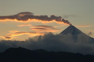
Alaska , Korovin :
AVO has detected no activity since a small explosion at the summit of Korovin Volcano on the evening of October 29. Korovin is one of the volcanoes that makes up the Atka volcanic complex. Satellite and webcam views were mostly cloudy over the last day. Seismicity is currently low.
The Atka volcanic complex is monitored by local seismic and infrasound sensors and webcam, satellite data, and regional lightning detection instruments.
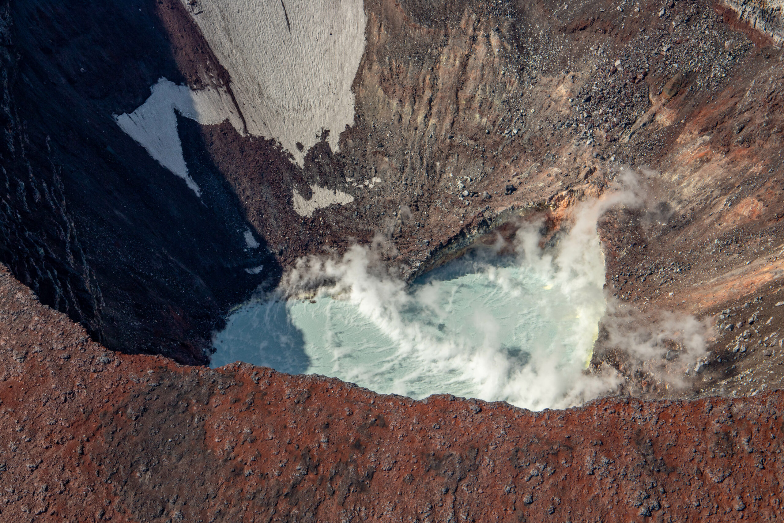
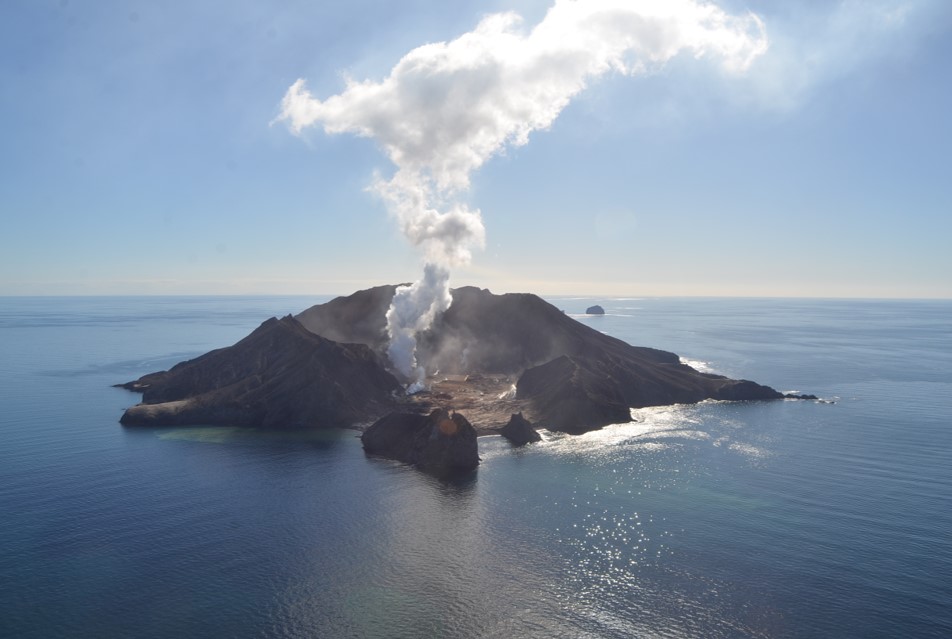
Steaming crater lake inside of the summit crater of Korovin Volcano in the Atka Volcanic Complex during an Alaska Volcano Observatory observation and gas measurement flight on August 28, 2025. The lake is warm with sulfur deposits floating on top due to an active hydrothermal system.
Remarks:
The Atka volcanic complex forms the northern part of Atka Island, located about 16 km north of the community of Atka and 1,761 km southwest of Anchorage. The Atka volcanic complex includes a possible older caldera and several younger vents, including Korovin Volcano, Mount Kliuchef, and Sarichef Volcano. Korovin Volcano, a 1553-m-high (5030 ft) stratovolcano, has been the site of most historical volcanic activity, and has a small, roiling crater lake that occasionally produces energetic steam emissions. Korovin has erupted several times in the past 200 years, including 1973, 1987, and 1998, and has likely had small ash emissions as recently as 2005. Typical recent Korovin eruptions produce minor amounts of ash and occasional but small lava flows. Reports of the height of the ash plume produced by the 1998 eruption ranged as high as 10,600 m (35,000 feet) above sea level. Mount Kliuchef is composed of a series of five vents aligned northeast–southwest. The two main summit vents of Kliuchef appear relatively young and the easternmost was probably the source of an 1812 eruption that is sometimes attributed to Sarichef.
Source : AVO
Photo : Dietterich, Hannah / Alaska Volcano Observatory / U.S. Geological Survey.
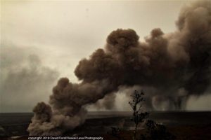
New Zealand , White Island :
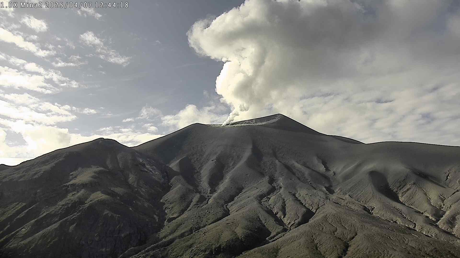
Two short-lived eruptions observed yesterday at Whakaari/White Island. Volcanic Alert Level Remains at level 3 and Aviation Colour Code remains Orange.
Published: Fri Oct 31 2025 3:00 PM
Based on webcam observations we observed two distinct eruptions yesterday (30th October) at 12:30 pm and again at 6:40 pm. No further eruption has been observed since. The Volcanic Alert Level remains at level 3 and the Aviation Colour Code remains Orange.

We reported yesterday that a possible eruption had occurred yesterday at 12:30 pm. Observations from the GeoNet cameras in the Bay of Plenty showed that another small-low energy eruption occurred at around 6:40 pm. From the webcams, the second of those eruptions deposited ash close to the island over the short period of the eruption. Our colleagues at MetService have not detected volcanic ash in the observed plumes using satellite imagery but SO2 was detected. The event seems to have lasted for a few minutes, and no further eruption has been observed.
Short-lived increases in degassing or steam may generate plumes of gas (possibly containing minor volcanic ash) with little or no warning over the coming days.
Earth Sciences NZ Volcano Monitoring Group and National Geohazards Monitoring Centre will continue to closely monitor Whakaari/White Island for any changes in activity. Without sensors on the Island, our monitoring continues to rely on remote cameras, satellite imagery, and periodic observation and gas flights to monitor Whakaari/White Island. We will provide further updates when information becomes available.
Source : Agnes Mazot / Duty Volcanologist / Geonet .
Photos : Geonet , Brad Scott.
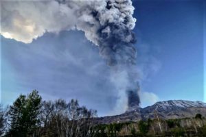
Colombia , Purace – Los Coconucos volcanic chain:
Popayán, October 28, 2025, 3:00 PM
Regarding the monitoring of activity at the Puracé volcano – Los Coconucos volcanic chain – the Colombian Geological Survey (SGC), an agency under the Ministry of Mines and Energy, reports the following:
During the week of October 21-27, 2025, a continuous volcanic tremor signal was persistently recorded, associated with the increased degassing observed in the Puracé volcano crater since September. Earthquakes related to fluid movement were low-energy and primarily located beneath the western flank of the crater, at depths of less than 1 km.
Compared to previous weeks, fracture seismicity remained stable, both in number and seismic energy released. The events mainly occurred between the Puracé, Piocollo and Curiquinga volcanoes, at depths between 1 and 3 km, and with a magnitude of less than 1. Satellite observations and field instruments revealed that sulfur dioxide (SO₂) emissions remained constant, with values similar to those of previous weeks.
Furthermore, the slow deformation process detected after the eruptive episode of the Curiquinga volcano on January 20, 2025, continues. Images captured by satellite sensors and visible and infrared webcams have continued to show degassing phenomena, with a maximum column height of approximately 1.7 km, measured from the summit of the Puracé volcano, as well as thermal anomalies inside the crater and in the fumarole field on the outer rim. In response to messages circulating on social media on October 24, 2025, the Geological Survey of Colombia (SGC) issued a statement clarifying that no changes in monitoring parameters indicated any ash emissions or seismicity related to this phenomenon. On October 25, field inspections were conducted in the La Base sector (Puracé Indigenous Reserve) and Cristales (Coconuco), without any ash deposits being observed. An inspection is currently underway in the Paletará area. The SGC reiterates the importance of consulting official sources and continues its monitoring of volcanic activity, promptly reporting any significant changes in its behavior.
In conclusion, the variations observed at the Puracé volcano – part of the Los Coconucos volcanic chain – indicate that the system remains active and that monitoring parameters remain above reference values. Therefore, the public is advised to avoid the higher elevations of the volcanic chain.
In the event of a yellow alert, phenomena such as sporadic ash emissions (minor eruptions with limited range and effects, the dispersion of which depends on wind direction), incandescence, small explosions within the crater, low-energy thermal anomalies, noises, felt seismic tremors, odors, precipitation of elemental sulfur near the crater and in hot springs and fumaroles, as well as degassing in areas other than the crater, may occur. Other possible phenomena include the formation of fissures and the occurrence of minor lahars.
The alert level for volcanic activity remains at yellow: Active volcano with changes in the baseline behavior of monitored parameters and other manifestations.
Source et photo : SGC.
Italy , Campi Flegrei :
Weekly Bulletin, October 20-26, 2025. (Publication date: October 28, 2025)
ACTIVITY SUMMARY
Based on monitoring data, the following points should be noted:
1) SEISMOLOGY: From October 20 to 26, 2025, 178 earthquakes of magnitude Md ≥ 0.0 (Mdmax = 2.8 ± 0.3) were recorded in the Phlegraean Fields region.
2) DEFORMATION: Data from the last 15 days show an increase in ground uplift, with a preliminary average monthly uplift rate of approximately 20 ± 5 mm/month. This value should be considered provisional, pending further data that will be available in the coming weeks.
3) GEOCHEMISTRY: During the reference week, the monitored geochemical parameters confirmed the long-term trend of warming of the hydrothermal system and increased flow rates already known.
SEISMOLOGY
From October 20 to 26, 2025, 178 earthquakes of magnitude Md ≥ 0.0 (Mdmax = 2.8 ± 0.3) were located in the Phlegraean Fields region.
66 earthquakes were recorded during two seismic swarms:
1. Starting at 02:37 UTC on October 25, 2025, 22 earthquakes of magnitude 0.0 ≤ Md ≤ 1.5 (± 0.3) occurred in the Pozzuoli-Agnano Pisciarelli region;
2. Starting at 22:51 UTC on October 25, 2025, 44 earthquakes of magnitude 0.0 ≤ Md ≤ 2.8 (± 0.3) occurred in the Pozzuoli-Agnano Pisciarelli region.
GROUND DEFORMATION
The permanent GNSS network of the Phlegraean Fields comprises 39 land and sea stations. The SOLO GNSS station (Solfatara) has been taken out of service because the building on which it was located (the « A. Trincone » school complex) is slated for demolition.
Data recorded after the series of earthquakes from February 15 to 19, 2025, showed an increase in the rate of ground uplift, with a monthly average of approximately 30 ± 5 mm/month until the end of March. Since the beginning of April, soil heave has continued to be recorded, with a monthly average of approximately 15 ± 3 mm/month.
Data from the last 15 days show an increase in soil heave, with a preliminary monthly average heave rate of approximately 20 ± 5 mm/month. This value should be considered provisional, pending further data that will be available in the coming weeks.
Source : INGV Vulcani.
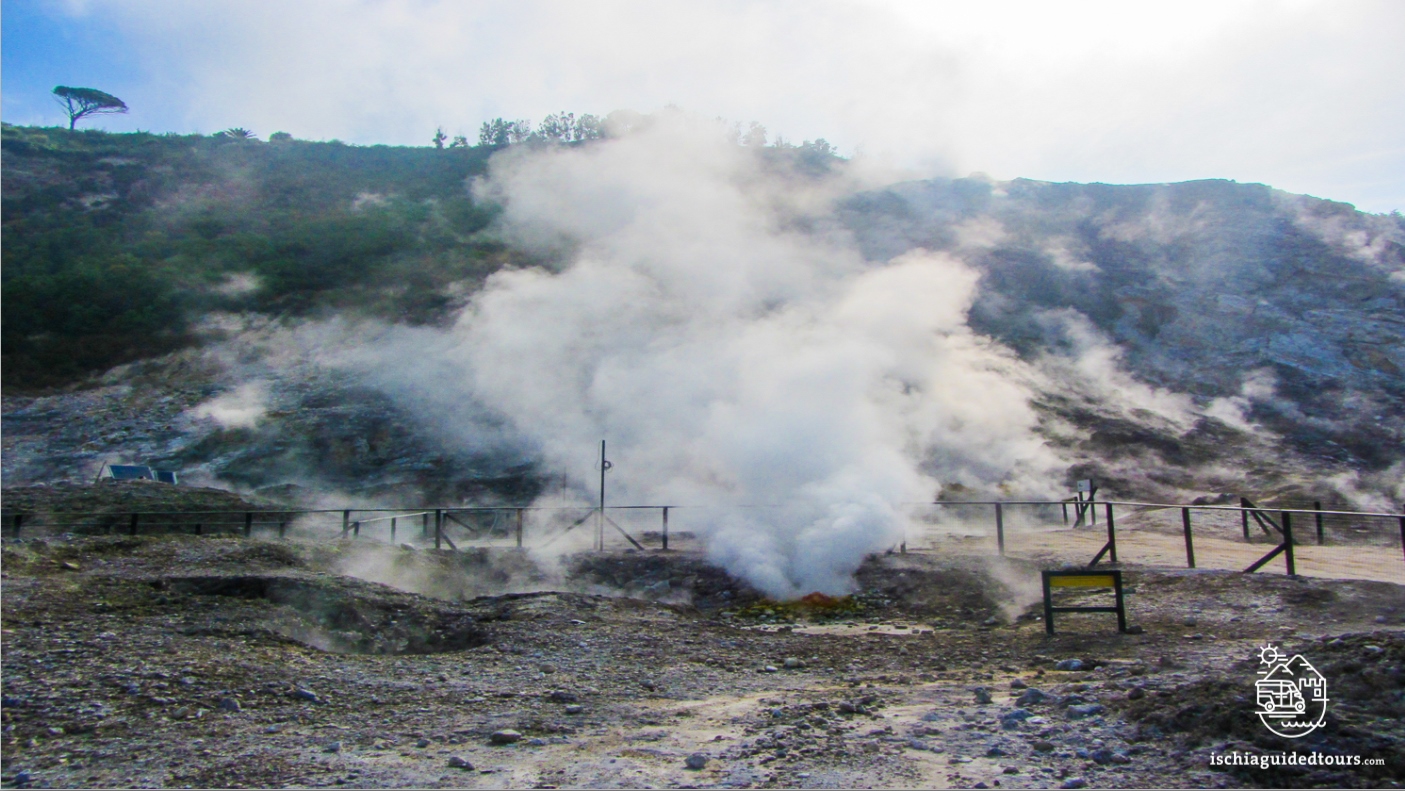
Photo : Ischia guide tours . com
Philippines , Kanlaon :
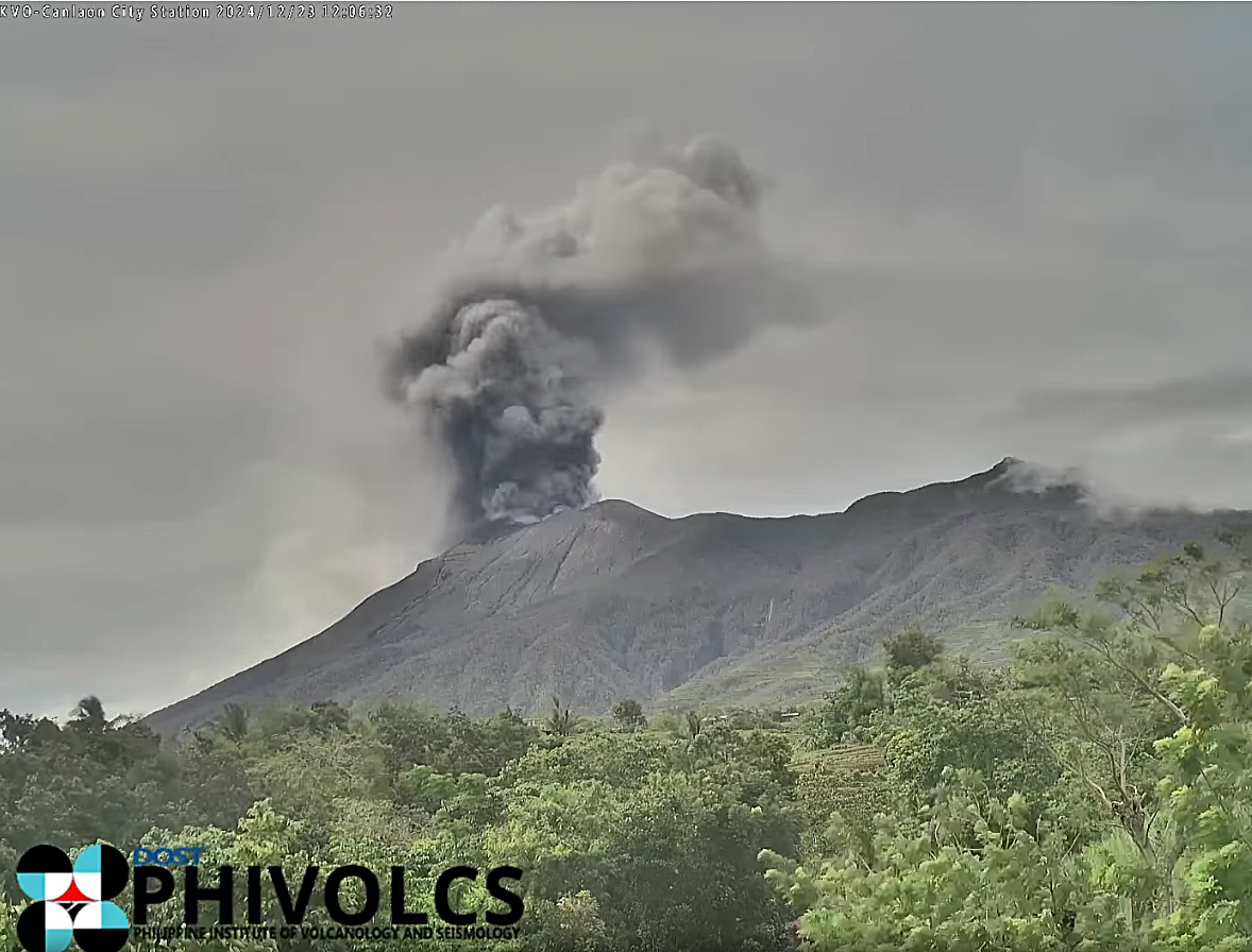
Ash emissions were reported at the summit crater of Kanlaon volcano on Negros Island, the Philippine Institute of Volcanology and Seismology (PHIVOLCS) announced Thursday afternoon.
PHIVOLCS specified that the emissions occurred between 12:37 and 12:57 p.m. Thursday.
« This event generated grayish plumes that rose up to 300 meters above the crater before drifting westward, as recorded by the IP camera at the Kanlaon Volcano Observatory (KVO-CC), » PHIVOLCS stated.
Alert Level 2 remains in effect for Kanlaon volcano, indicating heightened activity.
In its monitoring bulletin published Thursday morning, PHIVOLCS reported that four volcanic earthquakes were recorded beneath Kanlaon volcano between midnight Wednesday and midnight Thursday.
During this period, a small plume, reaching up to 200 meters in height, was observed emanating from the volcano and drifting westward.
A total of 877 tons of sulfur dioxide were ejected from the volcano on Wednesday, according to the Philippine Institute of Volcanology and Seismology (PHIVOLCS).
The volcanic edifice remained swollen.
Source : Phivolcs / Gmanetwork.
Photo : Archive phivolcs