September 15 , 2025.
Philippines , Kanlaon :
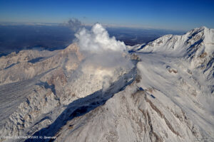
KANLAON VOLCANO ADVISORY, 15 September 2025 , 08:00 AM
This is a notice of increased seismic activity at Kanlaon Volcano.
A total of seventy-two (72) volcano-tectonic or VT earthquakes have been recorded by the Kanlaon Volcano Network between 12:00 AM and 08:00 AM today, 15 September 2025. These events ranged in strength between ML0.8 and ML 3.6 and were generated at 0 to 12 kilometers depths beneath the northwestern flanks of the volcanic edifice. The strongest of these VT earthquakes was felt at Intensity I in La Carlota City, Negros Occidental, and Canlaon City, Negros Oriental. VTs are generated by rock fracturing processes and the increase in VT activity strongly indicates progressive rock-fracturing beneath the volcano as rising magma or magmatic gas drives a path towards the surface. Volcanic sulfur dioxide (SO2) gas emissions from the summit crater of Kanlaon based on campaign mDOAS measurements yesterday, 14 September 2025, averaged 2,338 tonnes/day, near the medium-term average of 2,417 tonnes/day since 1 January 2025. These parameters indicate that the blockage of volcanic gas emission (or closed-system degassing) may result in pressurization and swelling of the edifice potentially leading to moderately explosive eruption.
The public is reminded that Alert Level 2 prevails over Kanlaon, which means that the volcano is in a state of increased unrest. The increase in VT events could lead to increased chances of steam-driven or phreatic eruptions or short-lived weak to moderately explosive eruptions occurring at the summit that could generate life-threatening volcanic hazards such as pyroclastic density currents or PDCs, ballistic projectiles, ashfall, rockfall and other. It is strongly recommended that communities within the 4-km Permanent Danger Zone or PDZ strictly remain evacuated and those within the 6-km radius from the summit crater be vigilant and ready in case unrest worsens. In addition, increased vigilance against potential syn-eruption lahars and sediment-laden streamflows in channels draining the edifice is strongly advised should intense rains occur during eruptive unrest. Civil aviation authorities must also advise pilots to avoid flying close to the volcano’s summit as ash from any sudden eruption can be hazardous to aircraft.
DOST-PHIVOLCS maintains close monitoring of Kanlaon Volcano and any new development will be immediately communicated to all concerned stakeholders.
Source : DOST-PHIVOLCS
Photo : vajiramandravi
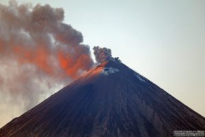
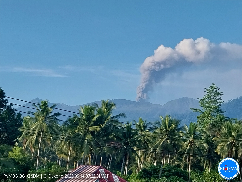
Indonesia , Dukono :
Mount Dukono erupted on Sunday, September 14, 2025, at 7:16 a.m. (local time). An ash column was observed about 1,000 m above the summit (about 2,087 m above sea level). The observed ash column was white to gray in color, with high intensity directed toward the northwest. At the time of writing, the eruption was still ongoing.
Seismic Observations
28 eruption earthquakes with amplitudes ranging from 6 to 14 mm and durations ranging from 35.1 to 89.9 seconds.
1 distant tectonic earthquake with amplitudes of 7 mm and durations of 77.39 seconds.
1 continuous tremor with amplitudes ranging from 1 to 6 mm, mainly 3 mm.
Recommendations
(1) People living around Mount Dukono and visitors/tourists are advised to refrain from any activity, climbing, or approaching the Malupang Warirang crater within a 4 km radius. (2) Since volcanic ash eruptions occur periodically and the distribution of ash follows the direction and speed of the wind, making the ash coverage area unstable, people living around Mount Dukono are advised to always have masks/nose covers and mouth masks available when needed to avoid the dangers of volcanic ash to the respiratory tract.
Source et photo : Magma Indonésie .
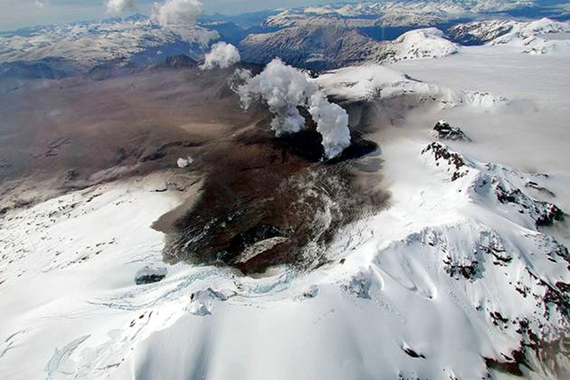
Chile , Hudson :
Seismology
Seismological activity during this period was characterized by:
1,563 VT-type earthquakes, associated with rock fracturing (volcano-tectonics). The most energetic earthquake, with a local magnitude (LM) of 2.9, occurred 5.8 km south of the volcanic edifice, at a depth of 1.2 km from the caldera center.
70 LP-type earthquakes, associated with fluid dynamics within the volcanic system (long period). The magnitude of the largest earthquake, evaluated using the reduced displacement (RD) parameter, was 14 cm².
9 HB-type earthquakes, associated with both rock fracturing and fluid dynamics within the volcanic system (hybrid). The most energetic earthquake had a reduced displacement (RD) of 2,465 cm² and a local magnitude (LM) of 3.0, located 8.9 km south-southeast of the volcanic edifice, at a depth of 0.5 km from the caldera center.
Fluid Geochemistry
No anomalies in sulfur dioxide (SO₂) emissions into the atmosphere have been reported in the area near the volcano, according to data published by the Tropospheric Monitoring Instrument (TROPOMI) and the Sulfur Dioxide Group of the Ozone Monitoring Instrument (OMI).
Geodesy
Geodetic activity during this period was characterized by low GNSS monitoring line extension rates (distance between stations). Consequently, no significant changes in the deformation of the volcanic system were observed.
Satellite Thermal Anomalies
During the period under review, no thermal alerts were recorded in the area associated with the volcano, according to the analytical processing of available Sentinel 2-L2A satellite images, in a combination of bands.
Satellite Geomorphological Analysis
Based on the observation of available Planet Scope and Sentinel 2-L2A satellite images, no morphological changes related to volcanic activity were identified.
Activity remained at levels considered low, suggesting the volcano’s stability.
The Volcanic Technical Alert remains in effect at:
GREEN TECHNICAL ALERT: Active volcano with stable behavior – No immediate risk
Source : Sernageomin
Photo : Patagonialink
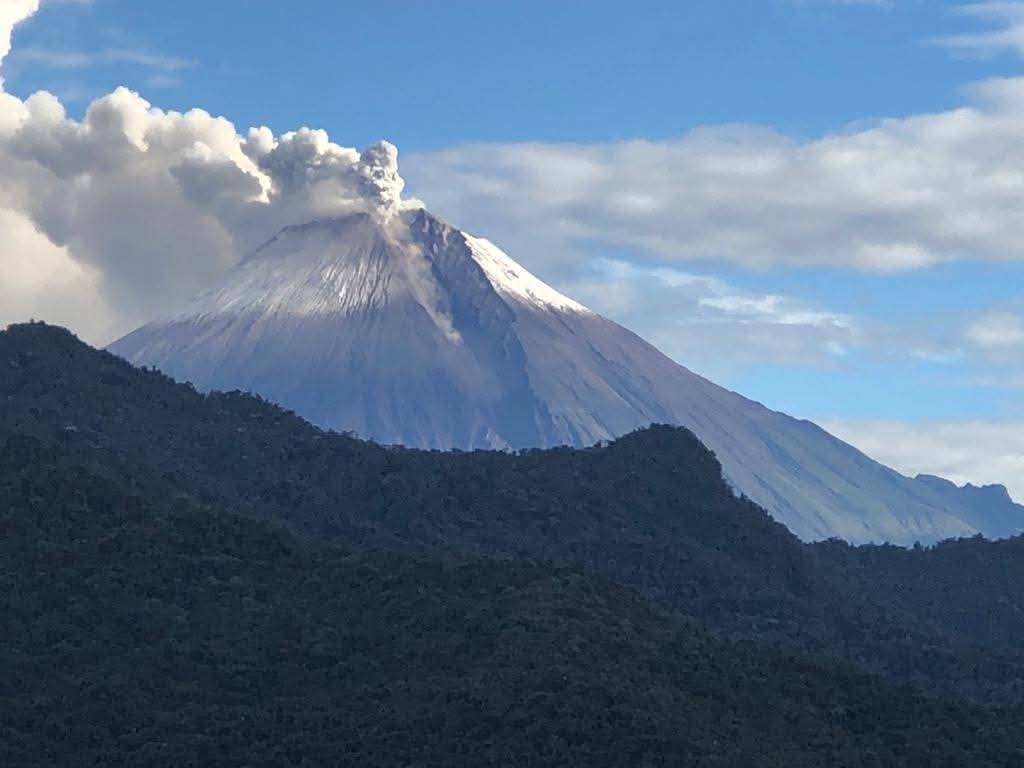
Ecuador , Sangay :
DAILY STATUS REPORT OF SANGAY VOLCANO, Sunday, September 14, 2025.
Information Geophysical Institute – EPN.
Surface Activity Level: Moderate, Surface Trend: No Change
Internal Activity Level: Moderate, Internal Trend: No Change
Seismicity: From September 13, 2025, 11:00 a.m. to September 14, 2025, 11:00 a.m.:
Seismicity:
Below is the count of seismic events recorded at the reference station.
Explosion (EXP): 60
Rainfall/Lahars:
No rainfall has been recorded in the volcanic area. **Heavy rainfall could remobilize accumulated material, generating mud and debris flows that would cascade down the volcano’s flanks and flow into adjacent rivers**.
Emission/Ash Plume:
Due to cloud cover in the volcanic area, no gas and/or ash emissions could be observed via the surveillance camera network. Last night, the GOES-19 satellite system detected a westward emission of gas and ash at an altitude of 700 meters above the crater. Meanwhile, the Washington-based VAAC agency issued four reports of westward and southwestward ash plumes at altitudes of 1,000 and 1,100 meters above the crater.
Other monitoring parameters:
The MIROVA-VIIRS satellite system recorded four thermal anomalies, and the FIRMS satellite system recorded nine thermal anomalies over the past 24 hours.
Observation:
Due to the cloud cover in the area, only one incandescence recording was observed in the volcano’s crater by the surveillance camera network. At the time of writing, the volcano remains entirely cloudy.
Alert level: Yellow
Source : IGEPN
Photo : Volcan Sangay / FB.
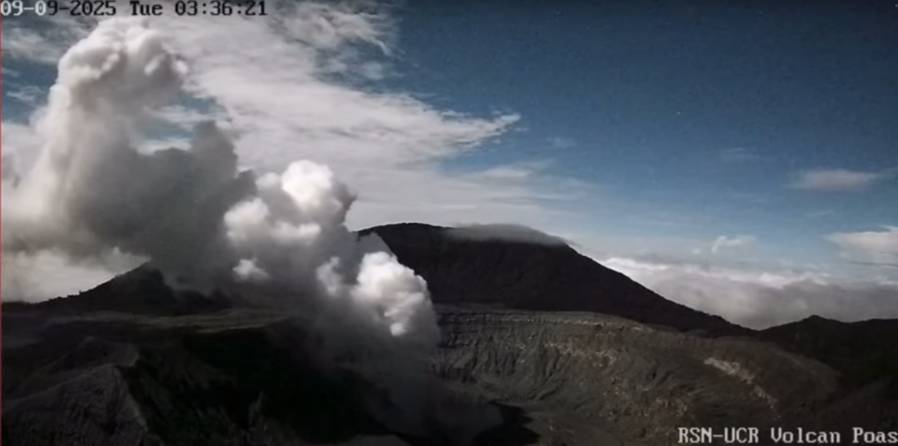
Costa Rica , Poas :
Latitude: 10.20°N;
Longitude: 84.23°W;
Altitude: 2,687 m
Current Activity Level: Alert
A violent phreatic explosion was recorded at Boca A this week, on Tuesday, September 9, at 10:48 a.m. The event occurred after the dividing wall between Boca A and C breached at 3:30 a.m., and Boca A was flooded with water from the Boca C lake. This caused the plume and glow of Boca A to disappear due to radiated thermal energy.
Since the night of Sunday, September 7, an increase in the strength of the Boca A plume has been observed, with frequent ash emissions, particularly during the night of Monday, September 8.
The variations in the Boca C plume observed since Sunday have been associated with a progressive increase in the intensity of the acoustic tremor. This peak was reached on the night of Monday, September 8, when prolonged ash emissions were observed. In addition to surveillance images, the rupture of the separation wall between the vents and the flooding of vent A were recorded by seismographs and infrasound sensors. The acoustic tremor then completely ceased and remains low to this day. The explosion had an infrasound magnitude (Mi) of 3.7, comparable to that of the March 10 eruptions (Mi 3.5 to 3.9) and slightly lower than that of the April eruptions, which reached several kilometers in height (Mi 4 to 4.0).
The amplitude of the background seismic tremor remains stable compared to recent months, despite a slight increase after the explosion. Two distal volcano-tectonic events were recorded this week. Between September 7 and 9, nine proximal volcano-tectonic earthquakes were recorded, located south of the Botos cone, at depths equivalent to sea level. The number of long-period events has continued to increase in recent weeks. Although slight vertical uplift was detected in the crater in recent days, it has now disappeared. The geodetic network no longer records any significant deformation.
MultiGAS stations measured an average SO2/CO2 ratio of 0.95 ± 0.5 this week, slightly lower than the previous week (1.4 ± 0.46). The H2S/SO2 ratio has remained very low (< 0.1) in recent weeks. Based on observed reports, the gases are interpreted as originating from a surface magmatic source. The ExpoGAS station, located at the visitor observation point, measured a maximum of 3.4 ppm SO2 this week. The DOAS stations measured an SO2 flux of 227 ± 97 t/d, lower than the previous week (400 ± 22 t/d). Furthermore, satellite measurements of atmospheric SO2 confirm a decrease this week, with values around 100 tons, with the exception of an isolated peak of 700 tons on Saturday, September 6.
The level of the new hyperacid lake at Mouth C fluctuated rapidly this week. First, it decreased significantly on September 9th with the rupture of the wall separating the two mouths, causing the flooding of Mouth A. Second, the level appears to have risen again, and on September 10th, the drop was not as pronounced as on the 9th.
The explosion projected bombs mainly southwest of Mouth A, up to 80 cm wide and 140 m from the eruptive focus. However, significant ballistic impacts (up to 50 cm wide) were also observed near Mouth C, suggesting an eruptive contribution from this mouth.
The lake, which now restricts the flow of hot gases at Mouth A, could generate significant phreatic eruptions that could affect the visited areas of the national park (for example, by projecting ballistic impacts towards the viewpoint).
Level 2 (Caution) does not exclude events involving ballistic impacts in the visited areas. Each phase of activity carries a potential risk.
Source : Ovsicori .
Photo : RSN