August 28 , 2025.
New Zealand , White Island :
Minor, short-lived eruptive activity observed at Whakaari/White Island. Volcanic Alert Level remains at 2 and Aviation Colour Code remains Yellow.
Published: Thu Aug 28 2025 3:30 PM
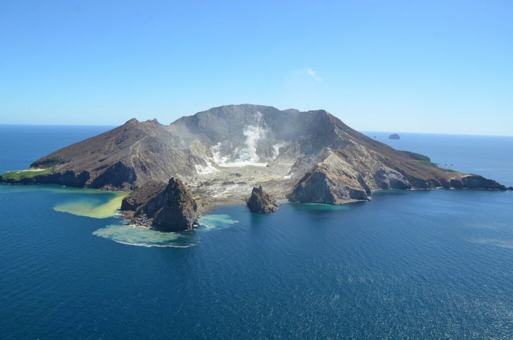
At 10.15 am local time, a minor, short-lived eruption started at Whakaari/White Island. This generated a plume which rose to less than 1 km above sea level and contained minor amounts of volcanic ash. The wind then dispersed the plume towards the north-east. The Volcanic Alert Level remains at level 2 and the Aviation Colour Code remains Yellow.
The eruption was identified on our Whakatāne webcam as a dark-coloured plume rising from Whakaari/White Island to a height of less than 1 km above sea level. The dark colour was due to the plume containing some volcanic ash, which was dispersed by the wind to the north-east of the island. After around 30 minutes, the plume returned to a paler colour, more typical of Whakaari’s normal steam and gas plume. Subsequently, occasional short-lived (seconds-minutes) darker plumes containing ash were observed, rising to 700 – 800 m above sea level. There has been no observed ash emission since about 12:00.
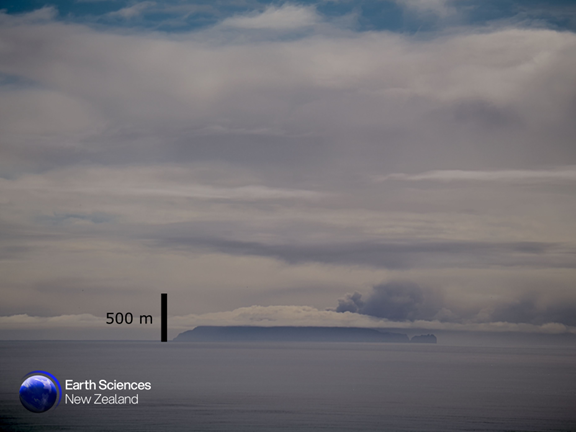
Webcam image from Whakatāne at 10:20 am NZDT, showing a darker plume, containing some volcanic ash being blown to the north-east.
It is unclear at this stage whether this morning’s activity will cease or progress to more sustained ash emission in the coming days. Given the short duration and small scale of this emission of ash, the Volcanic Alert Level remains at 2. We will continue to monitor the activity and provide updates on the activity and Volcanic Alert Level.
Although the Volcanic Alert Level remains at Level 2, short-lived increases in degassing or steam and gas plumes containing some volcanic ash can still occur with little or no warning, as shown by this morning’s activity.
The Volcanic Alert Level reflects the current level of volcanic activity and is not a forecast of future activity. While Volcanic Alert Level 2 is mostly associated with volcanic unrest hazards (including discharge of steam and hot volcanic gases, earthquakes, landslides and hydrothermal activity), the potential for eruption hazards remains.
The small scale of this morning’s activity means it is very unlikely that ash will impact the mainland. The level of volcanic activity would have to change significantly for this likelihood to increase.
The Earth Sciences New Zealand Volcano Monitoring Group and National Geohazards Monitoring Centre will continue to closely monitor for any further changes in activity. The Te Kaha and Whakatāne web cameras continue to provide observations of the plumes’ status, but local weather conditions may impact how the activity appears from the Bay of Plenty coast. As conditions allow, we will continue to conduct our regular overflights to perform observations and gas flux measurements. We also monitor sulphur dioxide emissions and ground deformation through satellite technology, whilst we also collaborate with MetService colleagues to monitor the plume in the atmosphere through satellite imagery.
Source : Geonet / Paul Jarvis / Duty Volcanologist
Photos : Geonet , Brad Scott, GNS Science.
Indonesia , Semeru :
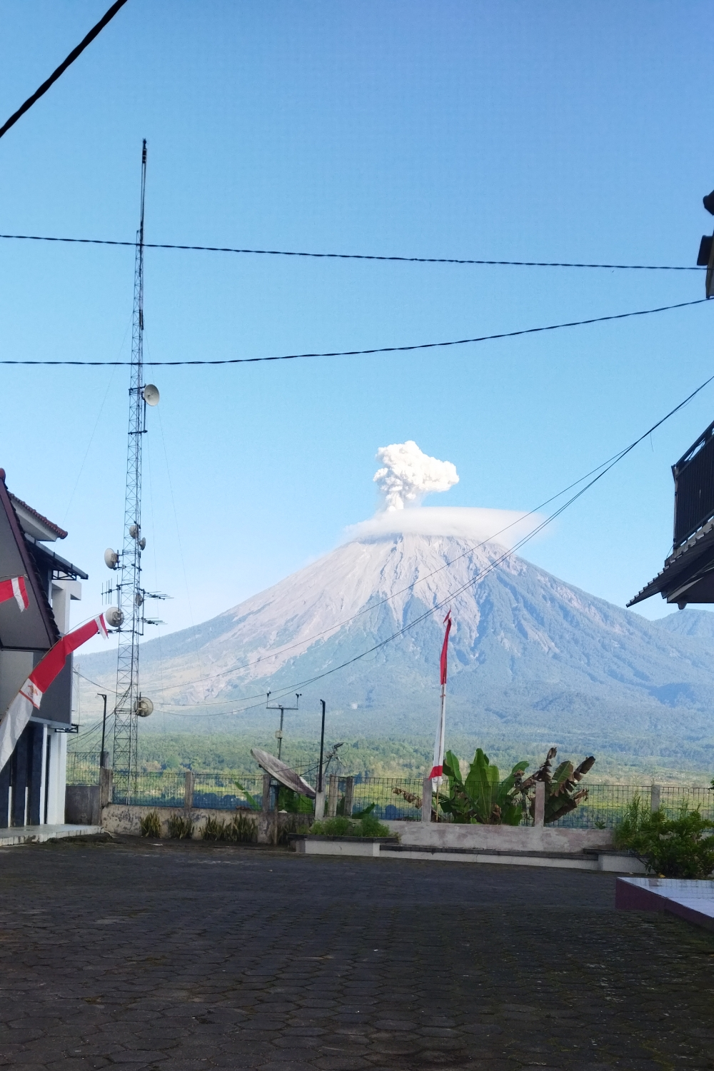
Eruption with volcanic ash cloud at 2058 UTC (0358 local). Best estimate of ash-cloud top is around 12723 FT (3976 M) above sea level or 960 FT (300 M) above summit. May be higher than what can be observed clearly. Source of height data: ground observer
VOLCANO OBSERVATORY NOTICE FOR AVIATION – VONA
Issued : August 27 ,2025
Volcano : Semeru (263300)
Current Aviation Colour Code : ORANGE
Previous Aviation Colour Code : orange
Source : Semeru Volcano Observatory
Notice Number : 2025SMR2768
Volcano Location : S 08 deg 06 min 29 sec E 112 deg 55 min 12 sec
Area : East java, Indonesia
Summit Elevation : 11763 FT (3676 M)
Volcanic Activity Summary :
Eruption with volcanic ash cloud at 20h58 UTC (03h58 local).
Volcanic Cloud Height :
Best estimate of ash-cloud top is around 12723 FT (3976 M) above sea level or 960 FT (300 M) above summit. May be higher than what can be observed clearly. Source of height data: ground observer.
Other Volcanic Cloud Information :
Ash cloud moving to southwest. Volcanic ash is observed to be white to gray. The intensity of volcanic ash is observed to be thick.
Remarks :
Eruption recorded on seismogram with maximum amplitude 22 mm and maximum duration 112 second.
The Pusat Vulkanologi dan Mitigasi Bencana Geologi (PVMBG) reported that activity continued at Semeru during 6-12 August, sometimes with multiple daily eruptive events recorded by the seismic network. Daily white-and-gray or gray ash plumes rose 200-1,000 m above the summit and drifted N, NW, W, and SW. The Alert Level remained at 2 (the second lowest level on a scale of 1-4). The public was warned to stay at least 3 km away from the summit in all directions, 8 km from the summit to the SE, 500 m from the banks of the Kobokan drainage as far as 13 km from the summit, and to avoid other drainages including the Bang, Kembar, and Sat, due to lahar, avalanche, and pyroclastic flow hazards.
Sources : Magma Indonésie , GVP.
Photo : Magma Indonésie .
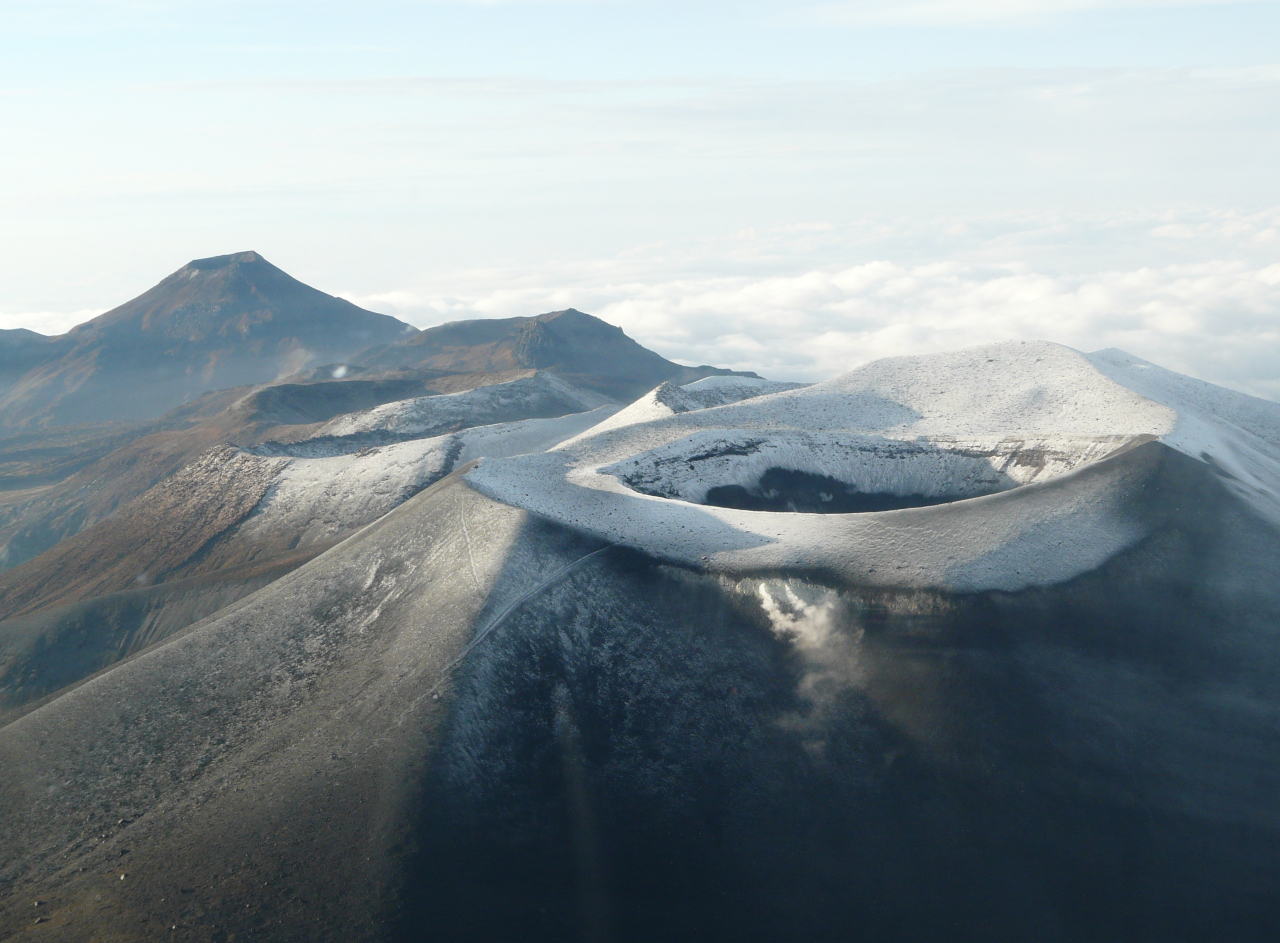
Colombia , Puracé – Los Coconucos volcanic chain :
Popayán, August 26, 2025, 3:00 p.m.
Regarding the monitoring of the activity of the Puracé Volcano – Los Coconucos Volcanic Range, the Colombian Geological Survey (SGC), an entity affiliated with the Ministry of Mines and Energy, reports that:
During the week of August 19-25, 2025, a decrease in the number of seismic events related to rock fracturing processes was recorded, mainly between the Puracé and Piocollo volcanoes, at depths between 1 and 3 km, with calculated magnitudes below 1.0. Similarly, earthquakes related to fluid movements were characterized by low energy input and occurred mainly beneath the western flank of the Puracé volcano crater, at a depth of less than 1 km.
Satellite and ground-based instruments have recorded moderate levels of sulfur dioxide (SO2) emissions. Furthermore, the slow deformation process detected after the eruption of Curiquinga Volcano on January 20, 2025, persists.
Visible and infrared webcam images continue to show degassing processes and thermal anomalies inside the Puracé Volcano crater and in the fumarole field on its outer rim.
In conclusion, the variations observed at the Puracé volcano and the Los Coconucos volcanic chain indicate that the system remains active and that monitoring parameters remain above their baseline.
In the yellow alert status, phenomena such as sporadic ash emissions (minor eruptions of limited magnitude and effects, whose dispersion depends on wind direction), the presence of incandescence, small explosions in the crater, low-energy thermal anomalies, noise, felt earthquakes, odors, precipitation of elemental sulfur near the crater and in hot springs and fumaroles, as well as degassing in areas other than the crater, may occur. Minor fissures and lahars, among others, may also form.
The alert status for volcanic activity remains yellow: active volcano with changes in the baseline behavior of monitored parameters and other manifestations.
Source et photo : SGC.
Japan , Sakurajima :
The Japan Meteorological Agency (JMA) reported ongoing eruptive activity at Minamidake Crater (Aira Caldera’s Sakurajima volcano) during 18-25 August. There was nightly crater incandescence visible in webcam images and occasional very small eruptive events. Sulfur dioxide emissions were characterized as extremely high on 20 August, averaging 3,300 tons per day. An explosion at 05h21 on 22 August generated an ash plume that rose 1.7 km above the crater rim and drifted SE. Eruptive events at 07h33 on 22 August, at 21h59 on 23 August, and at 00h13, 10h40, and 17h24 on 24 August produced ash plumes that rose 1.1-1.5 km above the crater rim; some of the plumes rose straight up while others drifted SE. Ash plumes were continuously emitted during 01h52-10h25 on 25 August, rose as high as 1.8 km above the crater rim, and drifted N. The Alert Level remained at 3 (on a 5-level scale), and the public was warned to be cautious within 2 km of both the Minimadake and Showa craters.
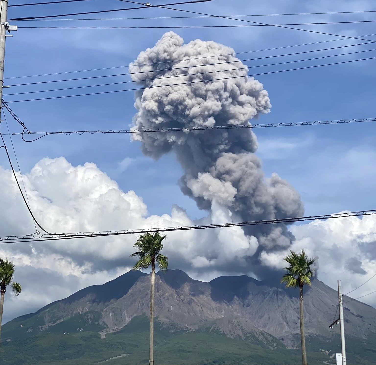
The Aira caldera in the northern half of Kagoshima Bay contains the post-caldera Sakurajima volcano, one of Japan’s most active. Eruption of the voluminous Ito pyroclastic flow accompanied formation of the 17 x 23 km caldera about 22,000 years ago. The smaller Wakamiko caldera was formed during the early Holocene in the NE corner of the caldera, along with several post-caldera cones. The construction of Sakurajima began about 13,000 years ago on the southern rim and built an island that was joined to the Osumi Peninsula during the major explosive and effusive eruption of 1914. Activity at the Kitadake summit cone ended about 4,850 years ago, after which eruptions took place at Minamidake. Frequent eruptions since the 8th century have deposited ash on the city of Kagoshima, located across Kagoshima Bay only 8 km from the summit. The largest recorded eruption took place during 1471-76.
Sources : Japan Meteorological Agency (JMA) , GVP .
Photo : Kumiko Nagai ( archive)
Papua – New Guinea , Ulawun :
The Rabaul Volcano Observatory (RVO) reported that activity at Ulawun was low during 1-20 August. Summit emissions occasionally observed during periods of clearer weather were characterized as white with variable densities; weather clouds obscured views of the summit on most days. There were reports of brief periods of minor summit incandescence observed from the Bakada and Likuranga areas to the NE, but those observations were unconfirmed. Seismicity was dominated by small low- and high-frequency volcanic earthquakes, with low-frequency earthquakes being the dominant signal. Occasionally periods of low-level volcanic tremors were recorded by the seismic network, lasting between one hour and several hours. The Alert Level remained at Stage 1 (the lowest level of a four-stage scale).
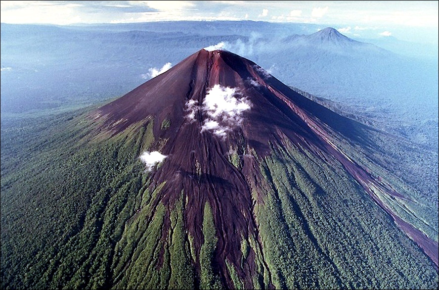
The symmetrical basaltic-to-andesitic Ulawun stratovolcano is the highest volcano of the Bismarck arc, and one of Papua New Guinea’s most frequently active. The volcano, also known as the Father, rises above the N coast of the island of New Britain across a low saddle NE of Bamus volcano, the South Son. The upper 1,000 m is unvegetated. A prominent E-W escarpment on the south may be the result of large-scale slumping. Satellitic cones occupy the NW and E flanks. A steep-walled valley cuts the NW side, and a flank lava-flow complex lies to the south of this valley. Historical eruptions date back to the beginning of the 18th century. Twentieth-century eruptions were mildly explosive until 1967, but after 1970 several larger eruptions produced lava flows and basaltic pyroclastic flows, greatly modifying the summit crater.
Sources: Rabaul Volcano Observatory (RVO) , GVP.
Photo : Ulawun with Bamus behind it to the right. (Dandees, via Panoramio)