August 14 , 2025.
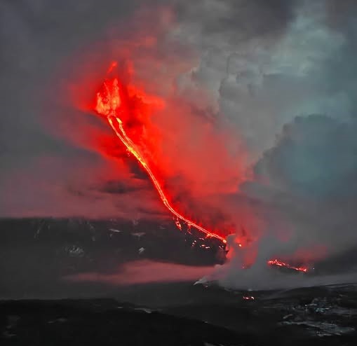
Italy / Sicily , Etna :
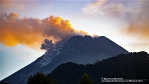
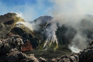
Etna Activity Statement, August 14, 2025, 03:14 (01:14 UTC)
The National Institute of Geophysics and Volcanology, Osservatorio Etneo, reports that surveillance cameras are observing a lava flow at the summit, advancing southward.
Volcanic tremors remain average, with increasing intensity; the sources are located at approximately 2,900 meters above sea level, between the Voragine and Northeast craters. Infrasound activity is low, both in number and amplitude, and localized events are located near the Northeast crater.
Signals from ground deformation monitoring networks show no significant changes.
Updates will be provided promptly, and in any case within 3 hours of the publication of this press release.
Source : INGV
Photo : Giovinsky Aetnensis / FB.
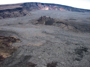
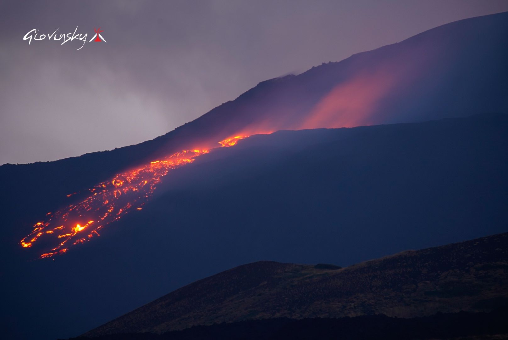
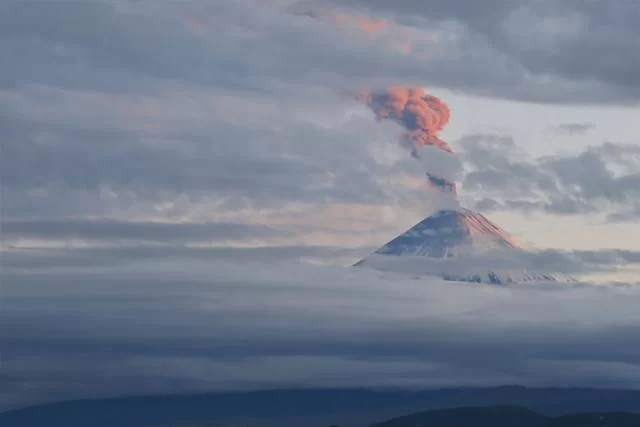
Kamchatka , Klyuchevskoy :
VOLCANO OBSERVATORY NOTICE FOR AVIATION (VONA)
Issued: August 14 ,2025
Volcano: Klyuchevskoy (CAVW #300260)
Current aviation colour code: ORANGE
Previous aviation colour code: orange
Source: KVERT
Notice Number: 2025-73
Volcano Location: N 56 deg 3 min E 160 deg 38 min
Area: Kamchatka, Russia
Summit Elevation: 4750 m (15580 ft)
Volcanic Activity Summary:
A summit explosive-effusive eruption of the volcano continues. A move of lava flows and ash emission from summit crater of the volcano continues. Satellite data by KVERT showed explosions sent ash up to 6.5 km a.s.l., and ash plume is extending for 52 km to the east of the volcano.
An extrusive-effusive eruption of the volcano continues. The danger of ash explosions up to 10 km (32,800 ft) a.s.l. remains. Ongoing activity could affect international and low-flying aircraft.
Volcanic cloud height:
6000-6500 m (19680-21320 ft) AMSL Time and method of ash plume/cloud height determination: 20250814/0330Z – Video data
Other volcanic cloud information:
Distance of ash plume/cloud of the volcano: 52 km (32 mi)
Direction of drift of ash plume/cloud of the volcano: E / azimuth 99 deg
Time and method of ash plume/cloud determination: 20250814/0156Z – SNPP 15m16
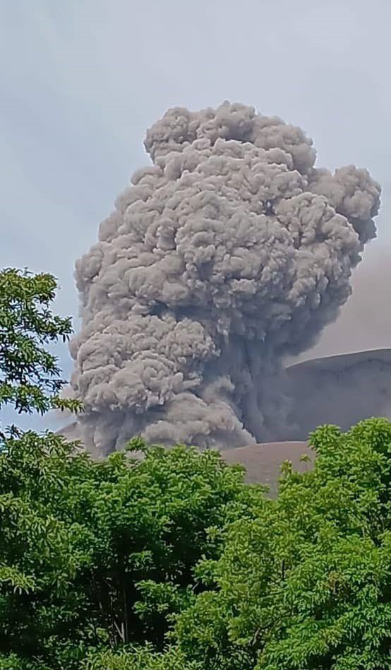
According to the Kamchatka Volcanological Station a group of tourists and guides visited the volcano for a few days during 7-8 August, when clearer weather allowed for visual observations and photographs of the lava flow. Photographs on 7 August showed that lava overflowed the rim in two areas, separated by a higher rocky area along the crater rim. The two flows merged into one in an area about a third of the way down the flank. Lava fountains rose from the summit crater. The visitors described loud noises through the night, and noted that glow from the lava flow was easily seen from inside closed tents. During the morning of 8 August they saw a large plume of gray ash rising several kilometers high. They walked within 15 m of the lava flow that was advancing along flatter ground, past the base of the edifice, and inspected the distal end of the flow. The flow was covered by gray rocks that rolled down the margins of the flow, appearing as an advancing gray avalanche of blocks with patches of red-hot material inside. During 8-9 August ashfall was reported in Klyuchi (30 km NNE). The group was unable to see the volcano again during most of 9-11 August due to weather conditions, though they continued to hear eruption noises. During a few instances of cleared weather, they noted that the flow was wider and lower, likely melting into the glacier. Activity had decreased by late on 12 August; ash plumes rose as high as 2.2 km above the summit and drifted 140 km SSW. At 22h19 the Aviation Color Code was lowered to Orange. Dates and times are provided in Coordinated Universal Time (UTC); specific events are indicated in local time where specified.
Source : Kvert , GVP.
Photos : RIA Novosti , V. Levin and G. Kan / FB.
Japan , Shinmoedake :
The Japan Meteorological Agency (JMA) reported that eruptive activity continued at Shinmoedake (Shinmoe peak, a stratovolcano of the Kirishimayama volcano group) during 4-11 August. The number of volcanic earthquakes located beneath Shinmoedake, first detected in late October 2024, continued to fluctuate; volcanic tremor was also occasionally detected, notably during eruptive events. During a field visit on 6 August scientists observed white plumes rising as high as 100 m from multiple vents along the SE to the N parts of the crater floor and drifting NE. The emissions from the N part of the floor had decreased compared to 28 June observations. Sulfur dioxide emissions on 6 August were characterized as slightly high, averaging 500 tons per day (t/d). At 05h23 on 10 August an ash plume rose 3 km above the crater rim and drifted NE. Sulfur dioxide emissions were higher, averaging 2,800 t/d. Ashfall was reported in Kobayashi City (14 km NE) and Takaharu Town (15 km E), obscuring the lines on the roads in some areas. Ashfall was also reported in Saito City (55 km NE), Takanabe Town (65 km NE), Kijo Town (61 km NE), Kawaminami Town (67 km NE), and Tsuno Town (75 km NE). A sulfur odor was noted in Kijo Town and Kawaminami Town.
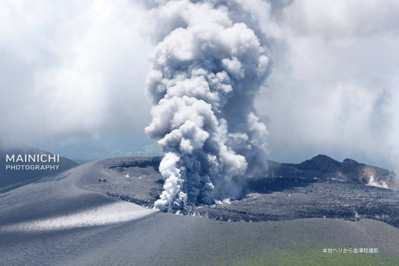
Emissions were ongoing until 01h34 on 11 August with ash plumes rising as high as 1 km above the crater rim and drifting NE, though weather conditions sometimes prevented visual confirmation. The Alert Level remained at 3 (on a 5-level scale) and the public was warned to exercise caution within 3 km from Shinmoedake Crater.
Kirishimayama is a large group of more than 20 Quaternary volcanoes located north of Kagoshima Bay. The late-Pleistocene to Holocene dominantly andesitic group consists of stratovolcanoes, pyroclastic cones, maars, and underlying shield volcanoes located over an area of 20 x 30 km. The larger stratovolcanoes are scattered throughout the field, with the centrally located Karakunidake being the highest. Onamiike and Miike, the two largest maars, are located SW of Karakunidake and at its far eastern end, respectively. Holocene eruptions have been concentrated along an E-W line of vents from Miike to Ohachi, and at Shinmoedake to the NE. Frequent small-to-moderate explosive eruptions have been recorded since the 8th century.
Sources : Agence météorologique japonaise (JMA) , GVP.
Photo : Mainichi via Alex Terry / FB.
Colombia , Puracé – Chaîne volcanique Los Coconucos :
Popayán, August 12, 2025, 3:30 p.m.
According to monitoring of the activity of the Puracé Volcano – Los Coconucos Volcanic Chain, the Colombian Geological Survey (SGC), an entity affiliated with the Ministry of Mines and Energy, reports that:
During the week of August 5-11, 2025, a slight increase in the number of seismic events, both fracture and fluid-related, was recorded compared to the previous week.
Earthquakes associated with rock fracturing were mainly located between the Puracé and Piocollo volcanoes, at depths between 1 and 3 km and with magnitudes below 1.2. The remaining seismic activity was located scattered near the crater of the Puracé volcano. On August 7, a magnitude 1.3 earthquake, the largest of the period under review, was recorded.
It was located 8 km northeast of the crater of the Puracé volcano, at a depth of 12 km. Fluid-related earthquakes occurred beneath this same crater, at a depth of less than 1 km, and were characterized by their low energy input.
Satellite and field detection instruments recorded moderate levels of sulfur dioxide (SO2) emissions. Furthermore, the slow deformation process detected after the eruption of Curiquinga Volcano on January 20, 2025, continues.
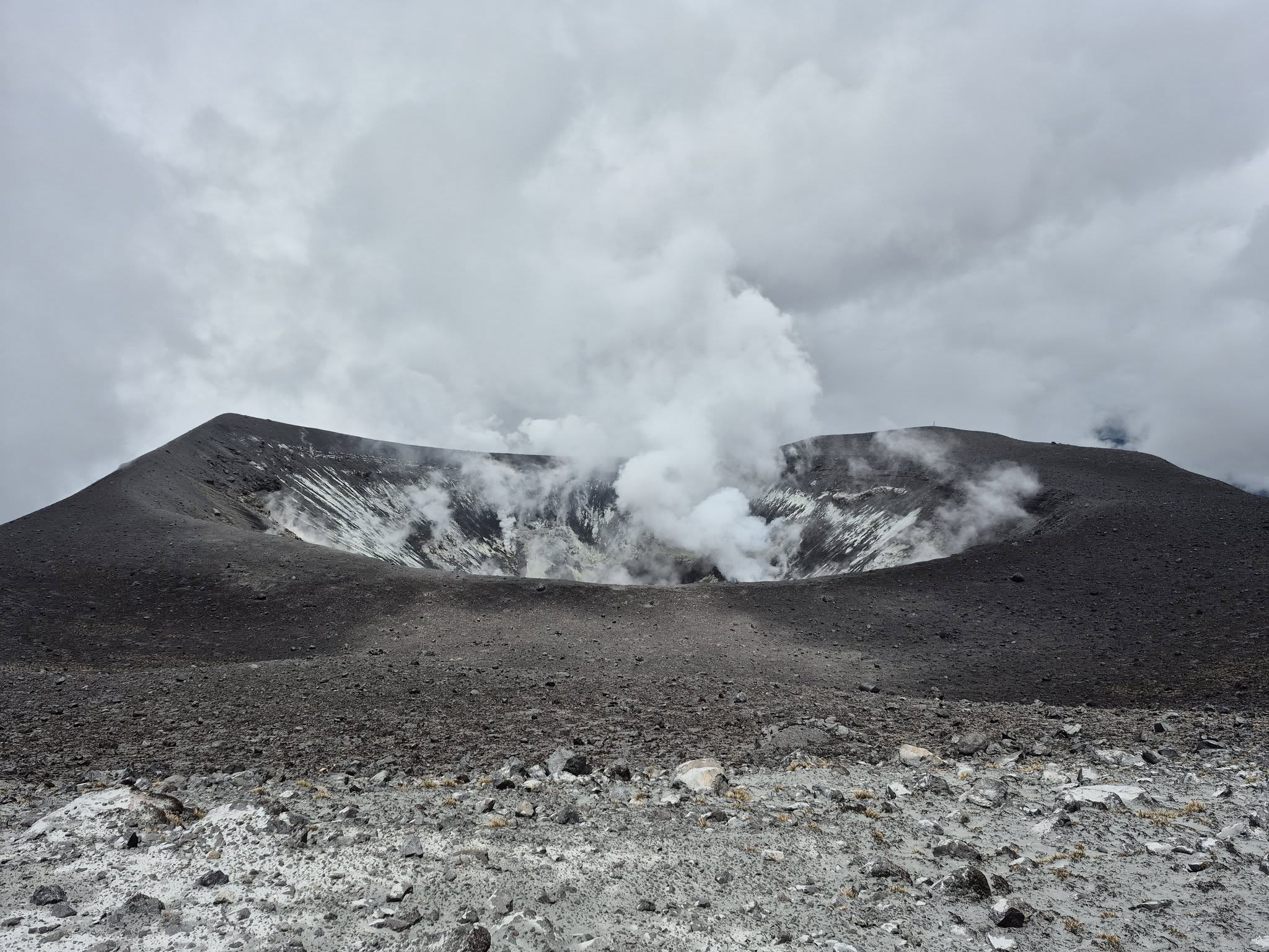
Visible and infrared webcam images continued to show degassing processes and thermal anomalies inside the Puracé Volcano crater and in the fumarole field on the outer rim of the crater, respectively.
In conclusion, the variations observed in the Puracé Volcano and Los Coconucos volcanic chain indicate that the system remains active and that monitoring parameters remain above their reference values.
The alert status for volcanic activity remains yellow: an active volcano exhibiting changes in the baseline behavior of monitored parameters and other manifestations.
Source et photo : SGC
Nicaragua , Telica :
The Washington Volcanic Ash Advisory Center (VAAC) reported that during 7-8 August ash plumes from Telica were identified in satellite images and/or webcam images drifting as far as 37 km WSW and SW at an altitude of 1.5 km (5,000 ft) a.s.l.
Telica, one of Nicaragua’s most active volcanoes, has erupted frequently since the beginning of the Spanish era. This volcano group consists of several interlocking cones and vents with a general NW alignment. Sixteenth-century eruptions were reported at symmetrical Santa Clara volcano at the SW end of the group. However, its eroded and breached crater has been covered by forests throughout historical time, and these eruptions may have originated from Telica, whose upper slopes in contrast are unvegetated. The steep-sided cone of Telica is truncated by a 700-m-wide double crater; the southern crater, the source of recent eruptions, is 120 m deep. El Liston, immediately E, has several nested craters. The fumaroles and boiling mudpots of Hervideros de San Jacinto, SE of Telica, form a prominent geothermal area frequented by tourists, and geothermal exploration has occurred nearby.
Sources : Washington Volcanic Ash Advisory Center (VAAC), GVP.