August 03 , 2025.
United States , Yellowstone :
YELLOWSTONE VOLCANO OBSERVATORY MONTHLY UPDATE . U.S. Geological Survey
Friday, August 1, 2025, 11:37 AM MDT (Friday, August 1, 2025, 17:37 UTC)
44°25’48 » N 110°40’12 » W,
Summit Elevation 9203 ft (2805 m)
Current Volcano Alert Level: NORMAL
Current Aviation Color Code: GREEN
Summary
Yellowstone Caldera activity remains at background levels, with 52 located earthquakes in July (largest = M2.8). Deformation measurements indicate that the annual summertime pause in long-term caldera subsidence started in late May. Two small eruptions of Black Diamond Pool in Biscuit Basin were recorded by a webcam on July 3 and July 14.
Recent Work and News
Sporadic minor eruptions continue at Steamboat Geyser in Norris Geyser Basin, but they have not reached an intensity that suggests a major eruption will occur soon. There have only been 2 major eruptions of the geyser so far during 2025, indicating that the episode of frequent activity that started in 2018 is coming to a close.
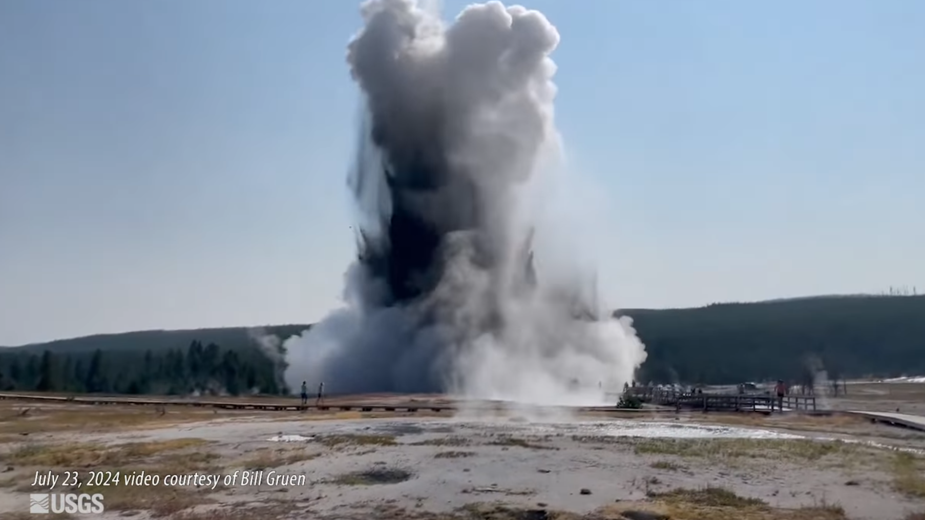
The new webcam at Biscuit Basin, installed in mid-May 2025 to track activity at Black Diamond Pool (where a hydrothermal explosion occurred on July 23, 2024), continues to send static images . During July, the webcam captured two small eruptions from the pool, on July 3 at 8:18 p.m. MDT and on July 14 at 3:23 a.m. MDT. Each eruption threw muddy water 20–30 feet (6–9 meters) into the air and lasted only a few seconds.
Also at Biscuit Basin, a new multi-parameter monitoring station was established in late July. The station includes a GPS antenna to track ground movement, seismometer to measure ground shaking, and microphone array to record low-frequency sound waves. Data from these sensors will soon be available via the Yellowstone Volcano Observatory website and other sources.
During the past month, field engineers from the University of Utah Seismograph Stations performed maintenance and upgrades on several seismic stations in the park and installed a new station near Slough Creek in the northeast part of the park. Field engineers from the EarthScope Consortium were also in Yellowstone performing maintenance and upgrades on continuous GPS stations.
Seismicity
During July 2025, the University of Utah Seismograph Stations, responsible for the operation and analysis of the Yellowstone Seismic Network, located 52 earthquakes in the Yellowstone National Park region. The largest event of the month was a micro earthquake of magnitude 2.8 located about 10 miles northeast of West Yellowstone, Montana, on July 30 at 3:10 a.m. MDT.
There were no swarms identified during the month of June.
Yellowstone earthquake activity remains at background levels.
Ground Deformation
Continuous GPS stations in Yellowstone Caldera continue to record the annual summertime pause in subsidence or transition to slight uplift, which is caused by seasonal changes related to snowmelt and groundwater conditions. Since late May, the caldera has risen by about 1 cm (less than half an inch), which is superimposed on the overall trend of subsidence that has been ongoing since 2015–2016.
Source : YVO
Photo : Capture d’écran USGS / Bill Gruen .
Indonesia , Lewotobi Laki Laki :
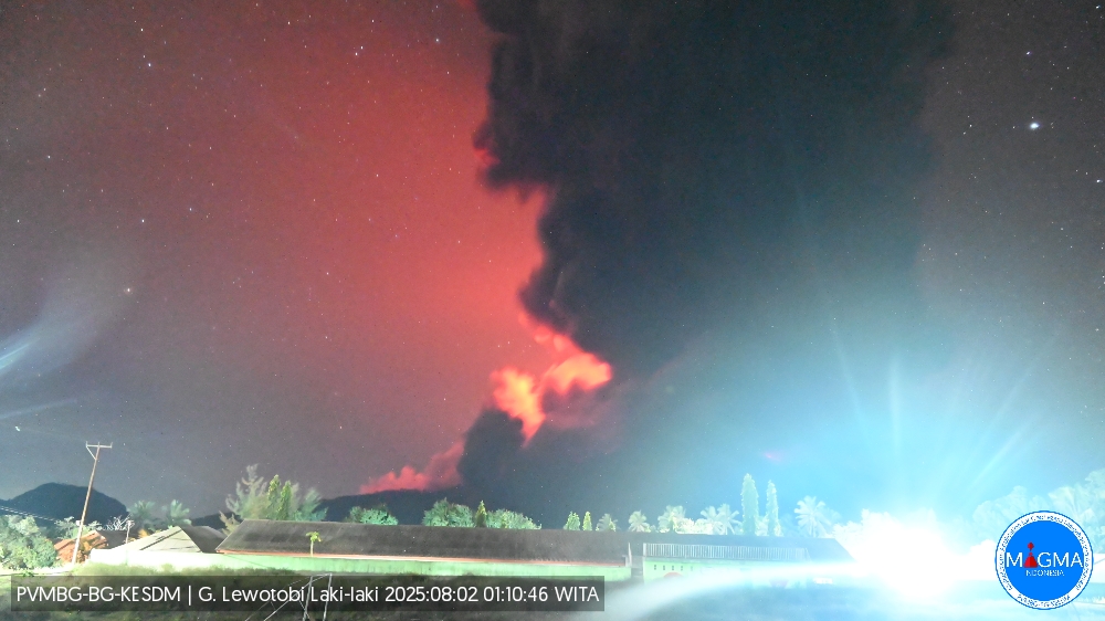
An eruption of Mount Lewotobi Laki-laki occurred on Saturday, August 2, 2025, at 1:05 a.m. WITA. The observed ash column reached a height of approximately 18,000 m above the summit (approximately 19,584 m above sea level). The ash column was gray to black in color, with a strong intensity, oriented toward the southwest, west, and northwest. At the time of writing, the eruption was still ongoing.
From 6:00 p.m. to 8:00 p.m. WITA, there was an increase in volcanic tremor, followed by explosive eruptions starting at 8:48 p.m. WITA. The ash column reached a height of approximately 18,000 meters above the mountain’s summit. The eruption material spread in all directions with ejections up to 3–4 km from the crater. This eruption was triggered by the accumulation of trapped gas over the past two weeks. Based on monitoring, volcanic tremor activity increased significantly and magma movement towards the surface was detected. Warning information was transmitted to the community around the volcano before the eruption.
VOLCANO OBSERVATORY NOTICE FOR AVIATION – VONA
Issued : August 02 , 2025 .
Volcano : Lewotobi Laki-laki (264180)
Current Aviation Colour Code : RED
Previous Aviation Colour Code : red
Source : Lewotobi Laki-laki Volcano Observatory
Notice Number : 2025LWK360
Volcano Location : S 08 deg 32 min 20 sec E 122 deg 46 min 06 sec
Area : East Nusa Tenggara, Indonesia
Summit Elevation : 5069 FT (1584 M)
Volcanic Activity Summary :
Eruption with volcanic ash cloud at 17h05 UTC (01h05 local).
Volcanic Cloud Height :
Best estimate of ash-cloud top is around 62669 FT (19584 M) above sea level or 57600 FT (18000 M) above summit. May be higher than what can be observed clearly. Source of height data: ground observer.
Other Volcanic Cloud Information :
Ash cloud moving from southwest, west to northwest. Volcanic ash is observed to be gray to dark. The intensity of volcanic ash is observed to be thick.
Remarks :
Eruption and ash emission is continuing. Eruption recorded on seismogram with maximum amplitude 47.3 mm. Tremor recorded on seismogram with maximum amplitude 14.8 mm.
Source et photo : Magma Indonésie .
Philippines , Kanlaon :
At 18h30 on 29 July the Philippine Institute of Volcanology and Seismology (PHIVOLCS) lowered the Alert Level for Kanlaon to 2 on a scale of 0-5) noting declining activity after the 13 May eruption. Volcanic earthquakes recorded by the seismic network averaged eight events per day during 14 May-29 July, fewer than the average of 14 events per day during 3 June 2024-13 May 2025. Volcano-tectonic earthquakes continued to be detected and were located mostly 0-15 km below the surface along a NW-SE transect though the edifice.
Despite the decline in average events per day, overall seismic energy represented by RSAM values had not significantly decreased. An ash plume was observed on 5 June, but afterwards only gas-and-steam plumes were seen rising from the summit crater. Sulfur dioxide emissions had decreased to an average of 1,857 tonnes per day during 14 May-29 July. A low rate of inflation had been detected by continuous Global Positioning System (GPS) and Electronic Distance Measurement (EDM) data since 2022, though deflation was detected during the last week of June and the first week of July.
PHIVOLCS urged communities to remain evacuated from the 4-km-radius Permanent Danger Zone (PDZ).
Sources: Philippine Institute of Volcanology and Seismology (PHIVOLCS) , GVP.
Photo : Sunstar .
Kamchatka , Krasheninnikov :
The Krasheninnikov Volcano erupted for the first time in 475 years.
On August 3rd at 4:50 a.m. local time, the first recorded eruption of the Krasheninnikov Volcano began on the Kamchatka Peninsula. The volcano was last active around 1550.
According to the Kamchatka Volcanic Eruption Response Team (KVERT), the ash column rose to a height of 5 to 6 kilometers. The ash plume extended 75 kilometers in an easterly direction.
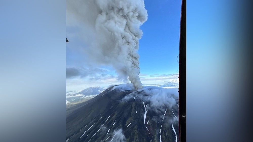
The volcano has been assigned an « orange » aviation hazard code, indicating a potential threat to aviation, particularly low-flying aircraft.
The Ministry of Emergency Situations strongly recommends that citizens refrain from visiting the eruption zone and strictly prohibits attempts to climb the volcano.
The Krasheninnikov Volcano is part of the Eastern Kamchatka Volcanic Belt and is located approximately 200 kilometers from the region’s administrative center, Petropavlovsk-Kamchatsky.
Source et photo : Centralasia . media
Indonesia , Bur Ni Telong :
SPECIAL REPORT ON THE INCREASE IN THE ACTIVITY LEVEL OF BUR NI TELONG VOLCANO FROM LEVEL I (NORMAL) TO LEVEL II (WASPADA) ON AUGUST 2, 2025
Bur Ni Telong is a stratovolcano with a maximum height of 2,624 m above sea level and located at coordinates 96°49’16 » E and 4°46’10 » N.
Visual observations between July 1, 2025 and August 2, 2025, at 06:00 WIB:
The volcano is clearly visible until it is covered by fog. No smoke from the crater has been observed. The seismicity data from July 1 to August 2, 2025, at 06:00 WIB are:
11 shallow volcanic earthquakes,
121 deep volcanic earthquakes,
24 local tectonic earthquakes
60 distant tectonic earthquakes.
During the period from July 1, 2025, to August 2, 2025, smoke emission activity from the Bur Ni Telong crater was still not observed. Despite this, deep volcanic earthquakes (VA) in July 2025 experienced a fairly significant increase, particularly on July 22 and 24, 2025. This indicates that magma or hydrothermal activity increased, but not continuously. During this period, 24 local tectonic earthquakes were also recorded, indicating an increase in regional pressure around Bur Ni Telong. This situation continues with the increase in shallow volcanic earthquakes from August 1 to 2, 2025, and therefore requires more intensive monitoring.
Based on visual and instrumental observations, the activity level of Bur Ni Telong is elevated from Level I (Normal) to Level II (Waspada) from 2 August 2025 at 06.00 WIB with the recommendations of the community and visitors/climbers do not approach the Bur Ni Telong crater area within a radius of 1.5 km and do not be in fumarole and solfatara areas during cloudy or rainy weather as gas concentrations can be life-threatening.
Source : PVMBG.
Photo : rafina2802 /wordpress.com