July 24 , 2025.
Indonesia , Marapi :
SPECIAL REPORT ON THE ERUPTION OF MARAPI VOLCANO, WEST SUMATRA, JULY 23, 2025, 7:23 AM WIB
Marapi Volcano (2,891 meters above sea level) is located in the districts of Agam and Tanah Datar, West Sumatra Province. Its activity is monitored visually and instrumentally from the Volcano Observation Post in Bukittinggi, West Sumatra Province. Its activity level has been Level II (WASPADA) since December 1, 2024.
Since December 3, 2023, Mount Marapi has erupted intermittently, with a fluctuating downward trend. On July 23, 2025, at 7:23 AM WIB, an eruption was recorded by a seismograph. It had a maximum amplitude of 30.5 mm and a duration of 1 minute and 18 seconds. The eruptive column observed from the observation post at 1,600 meters above the summit was white to gray, of strong intensity and inclined towards the southeast.
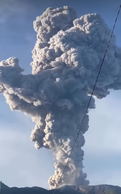
This morning’s eruption corresponds to a release of fluid pressure accumulated within Mount Marapi. Monitoring data to date indicate an inflationary trend within the volcano, making the volcanic environment unstable. Therefore, the volcano remains vulnerable to an eruption due to pressure accumulation or increase, but not to the extent expected in December 2023. We must remain vigilant.
Currently, the Volcanology and Geological Hazard Mitigation Center (PVMBG), the Geological Agency, has maintained Mount Marapi’s activity level at Level II (WASPADA). The main recommendation is that surrounding communities, mountaineers, visitors, and tourists refrain from entering the Verbeek crater or conducting activities within a 3-km radius.
Source : PVMBG
Photo : Capture d’écran via FB.
Iceland , Reykjanes Peninsula :
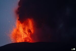
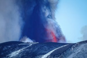
The Icelandic Meteorological Office (IMO) reported that a fissure eruption within the Reykjanes volcanic system began on 16 July in an area NE of Stóra Skógfell, along the Sundhnúkur crater row. According to a news report, the eruption was preceded by a seismic swarm and deformation, prompting authorities to evacuate 20-30 people from the Grindavík campground, about 100 people from the town of Grindavík, and about 200 people from the Blue Lagoon spa. A fissure trending NE-SW opened at around 03h56 and propagated N. Lava flows spread laterally from the fissure, mainly to the SE. As the eruption progressed, a second fissure opened. For a short period of time the interaction of groundwater and magma produced tephra-laden gas-and-steam plumes. By noon the entire fissure was about 2.4 km long and consisted of a series of segments that produced lava fountains and flows, with cones forming over vents along the fissure. Lava mainly flowed N and NE, spreading widely across Kálffellsheiði and toward Svartsengi. Lava covered about 3.2 square kilometers, based on satellite images. High concentrations of sulfur dioxide were measured over the Reykjanes Peninsula and were drifting W and SW over the ocean. Smoke from vegetation fires set by the eruption contributed to poor air quality in the region. Later in the evening residents of Grindavík were allowed back into town.

The eruption continued through the night. On 17 July seismic activity was low and eruptive activity was concentrated at about 10 vents. Lava continued to advance E. Foggy weather created poor visibility around the eruption site. Gas dispersal was widespread, with sulfur dioxide concentrations temporarily reaching hazardous levels in some localized areas, including in Akureyri. Due to high levels of volcanic gases authorities advised residents to stay indoors. By 11h30 on 18 July activity was concentrated along the central part of the fissure and the seismic network recorded little to no signals. Volcanic smog (vog) had spread over most of Iceland was visible over the ocean to the N and W. By 11h30 on 19 July the eruption was concentrated at 2-3 craters and volcanic tremor was low and steady. Two craters were active during 19-20 July and lava flowed E towards Fagradal. Poor air quality from significant amounts of sulfur dioxide emissions near the eruption site and vog continued to affect areas in the W half of Iceland. The northernmost crater ceased to be active at around 22h00 on 21 July; one crater was active at least through 14h40 on 22 July. Eastward advancement of the lava flows had slowed, and the flows inflated. IMO recommended that the public continue to check weather and gas-dispersion forecasts.
Sources: Icelandic Meteorological Office (IMO), GVP.
Photo : Ragnar Visage via FB.
Philippines , Mayon :
LAHAR ADVISORY FOR MAYON VOLCANO UNDER TROPICAL STORM “DANTE” AND SEVERE TROPICAL STORM “EMONG”
24 July 2025 , 7:00 AM
Based on the Weather Advisory #35 issued at 05:00 AM today by the Philippine Atmospheric Geophysical and Astronomical Services Administration (PAGASA), the passage of Tropical Storm “DANTE”, Severe Tropical Storm “EMONG” and ongoing Southwest Monsoon (Habagat) are expected to bring heavy to torrential rains over the Bicol Region. These rains could generate volcanic sediment flows or lahars, muddy streamflows or muddy run-off in rivers and drainage areas on Mayon Volcano. DOST-PHIVOLCS thus strongly recommends increased vigilance and readiness of communities in pre-determined zones of lahar and related hazards.
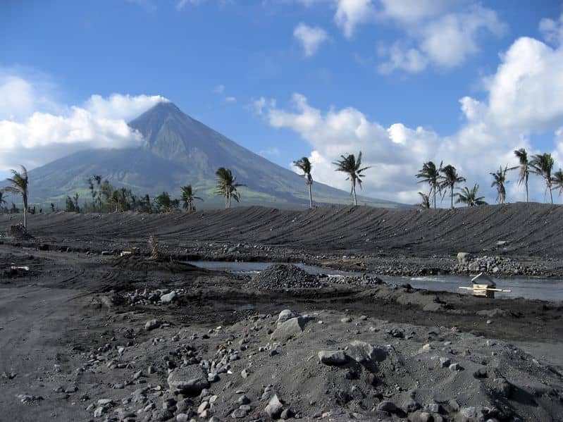
Heavy to torrential rainfall can generate post-eruption lahars on major channels draining Mayon Volcano by incorporating loose material from remnant pyroclastic density current (PDC) deposits of the 2018 and 2023 Mayon eruptions. The bulk of erodible PDC deposits occupies the watershed areas of the Miisi, Mabinit, Buyuan and Basud Channels. In addition, older and erodible eruption deposits that occupy the watershed areas on the eastern and western slopes of the edifice and can be remobilized as non-eruption lahars by erosion of banks and channel beds. Mayon lahars can threaten communities downstream of the above channels with inundation, burial and wash away. Potential lahars and sediment-laden streamflows may occur along the Miisi, Binaan, Anoling, Quirangay, Maninila, Masarawag, Muladbucad, Nasisi, Mabinit, Matanag, Basud and Bulawan Channels in Albay Province.
DOST-PHIVOLCS strongly advises the communities and local government units of the above identified areas of risk to continually monitor the rainfall conditions and take pre-emptive response measures for their safety.
Source : DOST-PHIVOLCS
Photo : Archive , auteur inconnu.
Japan , Sakurajima :
The Japan Meteorological Agency (JMA) reported ongoing eruptive activity at Minamidake Crater (Aira Caldera’s Sakurajima volcano) during 14-21 July. Very small eruptive events occasionally occurred during 14-16 July. Sulfur dioxide emissions were extremely high on 16 July, averaging 3,100 tons per day. An explosion at 13h28 on 17 July generated an ash plume that rose 3.3 km above the crater rim and drifted N. Large blocks were ejected as far as 1 km from the vent. Ash plumes continued to rise from the crater and drift N until 15h50. An eruptive event at 20h00 on 18 July produced an ash plume that rose 2 km above the crater rim and drifted N. Large blocks were ejected as far as 800 m from the vent. The Alert Level remained at 3 (on a 5-level scale), and the public was warned to be cautious within 2 km of both the Minimadake and Showa craters.
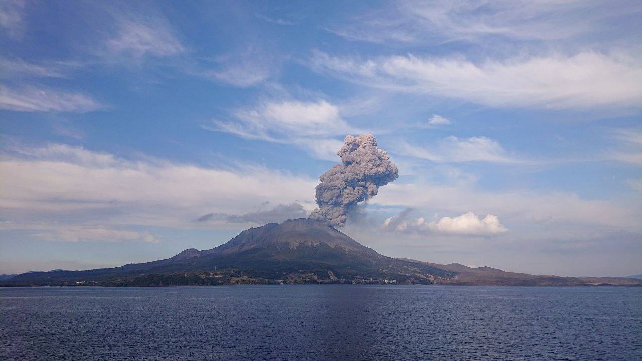
The Aira caldera in the northern half of Kagoshima Bay contains the post-caldera Sakurajima volcano, one of Japan’s most active. Eruption of the voluminous Ito pyroclastic flow accompanied formation of the 17 x 23 km caldera about 22,000 years ago. The smaller Wakamiko caldera was formed during the early Holocene in the NE corner of the caldera, along with several post-caldera cones. The construction of Sakurajima began about 13,000 years ago on the southern rim and built an island that was joined to the Osumi Peninsula during the major explosive and effusive eruption of 1914. Activity at the Kitadake summit cone ended about 4,850 years ago, after which eruptions took place at Minamidake. Frequent eruptions since the 8th century have deposited ash on the city of Kagoshima, located across Kagoshima Bay only 8 km from the summit. The largest recorded eruption took place during 1471-76.
Sources: Japan Meteorological Agency (JMA) , GVP
Photo : via Alex Terry / FB
Colombia , Chiles / Cerro Negro :
San Juan de Pasto, July 22, 2025, 4:40 p.m.
According to monitoring of the activity of the Chiles-Cerro Negro Volcanic Complex (CVCCN), the Colombian Geological Survey (SGC), an entity affiliated with the Ministry of Mines and Energy, reports that:
From July 15 to 21, 2025, the main variations in the monitored parameters compared to the previous week were as follows:
● Seismic activity and energy release decreased, returning to levels prior to the increase reported on July 9. Seismicity associated with rock fracturing within the volcanic edifice continues to predominate, followed by seismicity related to fluid dynamics.
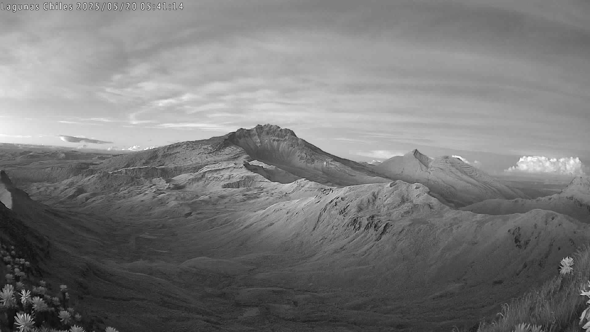
● Localized seismicity was concentrated in three main groups. The first group was located north of the summit of Chiles Volcano, in the collapse zone, with events within a radius of 1.6 km and depths between 2.4 and 4 km from its summit (4,700 m above sea level). A second group was recorded to the south, with similar depths (2.9 and 4 km) and a distance of up to 2.4 km from the summit. Both groups were characterized by low energy levels. The third group, located southeast of the summit and at a distance of up to 18.2 km, presented deeper earthquakes (between 7 and 17.9 km). These events combined fracturing and fluid dynamics and included the largest earthquake, with a magnitude of 2.9. ● Analysis of information obtained from satellite sensors and ground stations continues to indicate variations related to deformation processes in the volcanic area.
Based on the assessment and correlation of monitored parameters, the SGC recommends closely monitoring their development through weekly bulletins and other information published through our official channels, as well as instructions from local and departmental authorities and the National Disaster Risk Management Unit (UNGRD).
Volcanic activity remains on yellow alert: active volcano with changes in the baseline behavior of monitored parameters and other manifestations.
Source et photo : SGC.