July 18 , 2025.
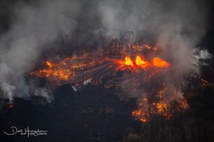
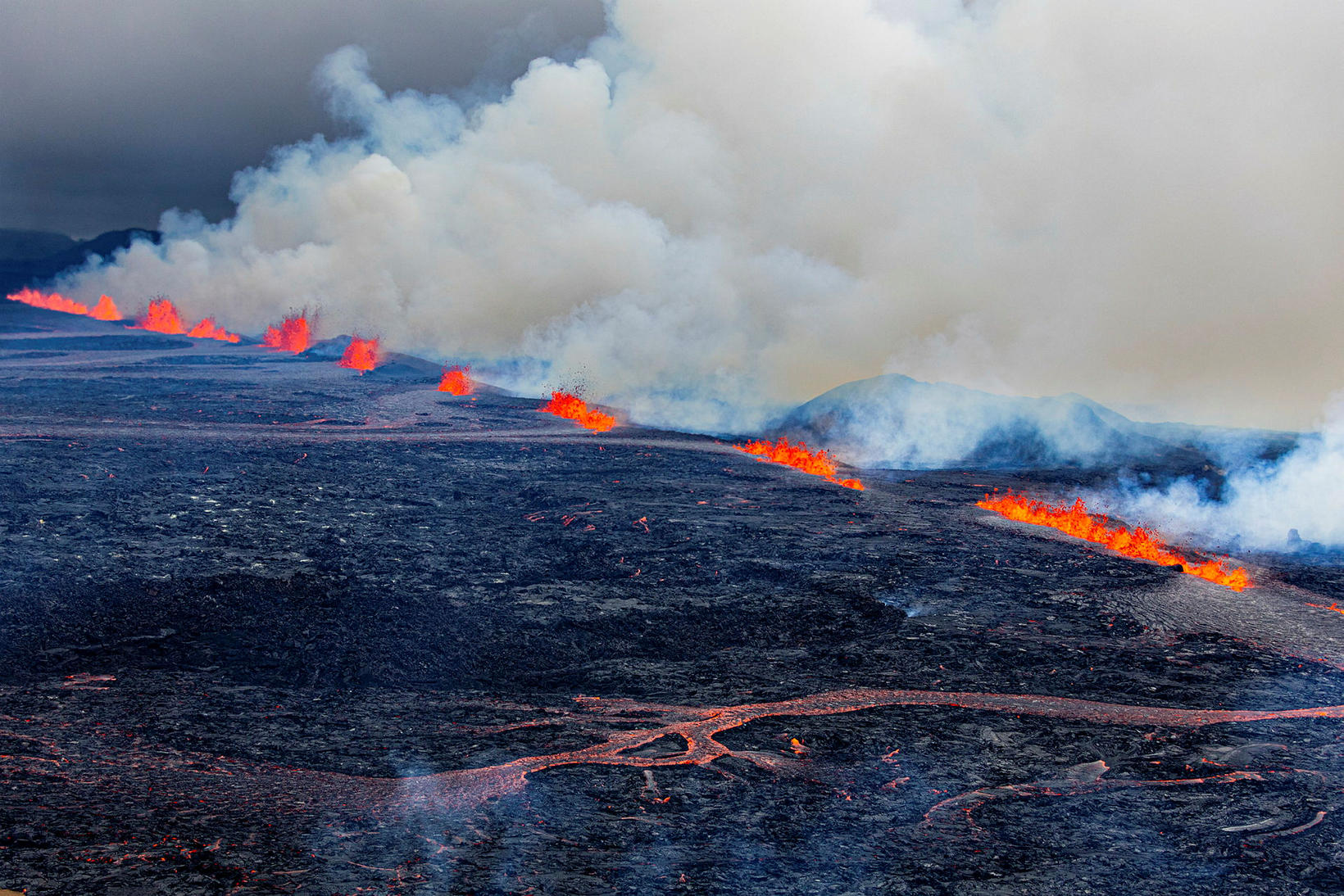
Iceland: Reykjanes Peninsula :
A volcanic eruption began on the Sundhnúkur crater row during the night — the twelfth eruption in the series since December 2023.
Benedikt Ófeigsson, head of deformation monitoring at the Icelandic Meteorological Office, told mbl.is that the eruption came as something of a surprise, even though experts knew nothing was certain.
First signs of magma movement shortly after midnight
An earthquake swarm began in the Sundhnúkur area at 11:55 p.m., and the first signs of magma movement were detected just after midnight.
More than a hundred earthquakes were recorded within about an hour after midnight, and Civil Protection raised the alert level due to the high likelihood of an eruption.
As a result, Grindavík and the Svartsengi area were evacuated. The evacuation went well, according to Hjördís Guðmundsdóttir, communications officer for Civil Protection. A number of residents remained in their homes in Grindavík, and a hotel near the Blue Lagoon had to be evacuated, where about 200 people were staying. A group of tourists was also at the campsite in Grindavík.

The HS Orka power station in Svartsengi was evacuated — two employees were on duty at the time. The company has now received permission from the Suðurnes police commissioner to send staff back in and resume operations.
Eruption southeast of Litla-Skógfell
The eruption began just before 4 a.m., with the source located southeast of Litla-Skógfell — roughly the same area where a crater formed during the August 2023 eruption.
The National Commissioner of Police declared a state of emergency in coordination with the Suðurnes police chief.
Shortly before the eruption, the Icelandic Meteorological Office estimated that the magma intrusion was about 6.5 kilometers long. Initially, based on GPS and deformation measurements, the eruption was expected to be small. Benedikt said early on that the fissure was about 700 meters long, but it has since extended and is now over 2 kilometers.
Lava is primarily flowing eastward, toward Fagridalur and Fagradalsfjall, while the gas plume is drifting northwest toward Reykjanesbær. People with respiratory sensitivities are advised to keep windows closed.
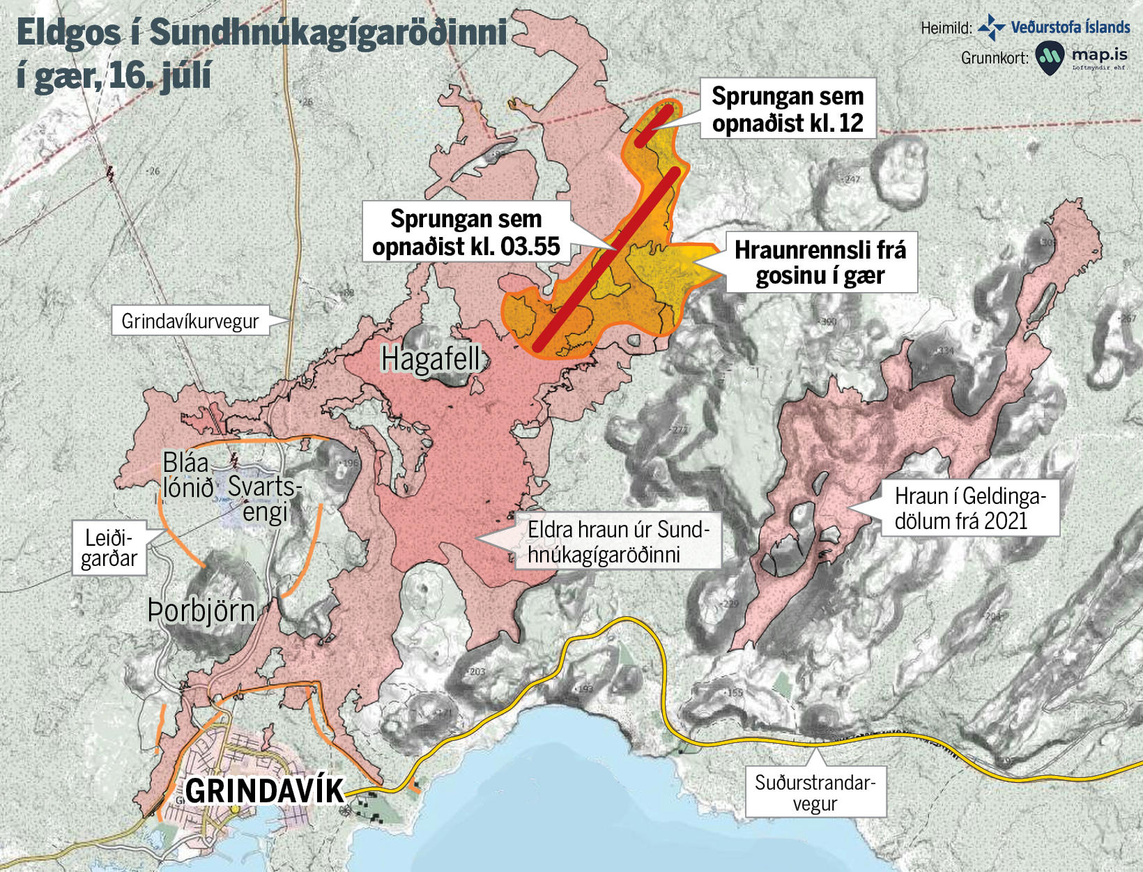
The red lines indicate the eruption fissures. The longer line marks the fissure that opened at 3:55 a.m. the night before last, while the shorter line marks the fissure that opened at noon yesterday. The orange area shows the lava flow from yesterday’s eruption.
Eruption sites far from Grindavík
The fissure that opened around noon yesterday lies northeast of Mt Hagafell as well, also trending northeast, but is slightly west of the larger fissure. It could be said to continue from the main fissure, shifted slightly to the west.
The image also shows that the eruption sites are considerably far from the town of Grindavík.
Eruption activity continues at Sundhnúkur, now concentrated in several craters near the middle and northern ends of the fissure.
Access to Grindavík has been reopened for residents, but tourists and the general public are still not allowed to enter the town at this time.
Source : MBL . IS
Photos : mbl.is/Árni Sæberg , map/mbl.is .
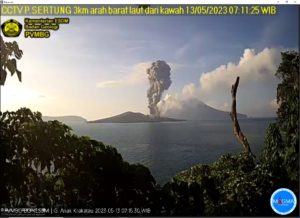
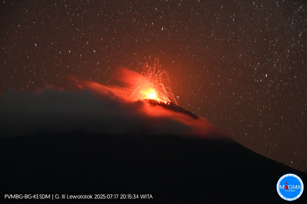
Indonesia , Ili Lewotolok :
An eruption of Mount Ili Lewotolok occurred on Thursday, July 17, 2025, at 8:15 p.m. (local time). No visual observations were made. The eruption was recorded by a seismograph with a maximum amplitude of 35.4 mm and a duration of 56 seconds.
Seismic Observations
44 eruption earthquakes with amplitudes ranging from 12.5 to 38.6 mm and durations ranging from 34 to 53 seconds.
50 emission earthquakes with amplitudes ranging from 1.9 to 11.7 mm and durations ranging from 31 to 60 seconds.
4 non-harmonic tremors with amplitudes ranging from 2.3 to 4.9 mm and durations ranging from 39 to 113 seconds.
Recommendations
At Activity Level III (SIAGA):
[1] Residents living near Mount Ili Lewotolok, as well as visitors, climbers, and tourists, are advised to refrain from entering or engaging in any activity within a 3 km radius of the activity center of Mount Ili Lewotolok. Be aware of the potential dangers of lava avalanches and pyroclastic flows originating from the south, southeast, west, and northeast sectors of Mount Ili Lewotolok.
(2) The public is advised not to panic if they hear a rumbling or roaring noise coming from the crater of Mount Ili Lewotolok, as this noise is characteristic of volcanic activity during an eruption. This powerful rumbling noise can cause severe vibrations in several parts of the building, including windows and glass doors.
Source et photo : Magma Indonésie .
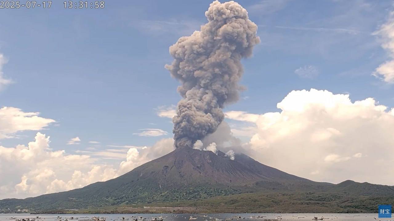
Japan , Sakurajima :
The Japan Meteorological Agency (JMA) reported ongoing eruptive activity at Minamidake Crater (Aira Caldera’s Sakurajima volcano) during 7-14 July. Nightly crater incandescence was visible in webcam images. Explosions at 0440 and 2314 on 9 July and at 1629 on 10 July, produced ash plumes that rose as high as 1.8 km above the crater rim and drifted W and NW. The first and last explosions ejected large blocks as far as 900 m from the vent. Ash plumes from eruptive activity on 13 July rose 1.1 km above the crater rim and drifted NW. The Alert Level remained at 3 (on a 5-level scale), and the public was warned to be cautious within 2 km of both the Minimadake and Showa craters.
The Aira caldera in the northern half of Kagoshima Bay contains the post-caldera Sakurajima volcano, one of Japan’s most active. Eruption of the voluminous Ito pyroclastic flow accompanied formation of the 17 x 23 km caldera about 22,000 years ago. The smaller Wakamiko caldera was formed during the early Holocene in the NE corner of the caldera, along with several post-caldera cones. The construction of Sakurajima began about 13,000 years ago on the southern rim and built an island that was joined to the Osumi Peninsula during the major explosive and effusive eruption of 1914. Activity at the Kitadake summit cone ended about 4,850 years ago, after which eruptions took place at Minamidake. Frequent eruptions since the 8th century have deposited ash on the city of Kagoshima, located across Kagoshima Bay only 8 km from the summit. The largest recorded eruption took place during 1471-76.
Sources: Japan Meteorological Agency (JMA) , GVP.
Photo : Webcam
Colombia , Puracé – Los Coconucos volcanic chain :
Popayán, July 15, 2025, 3:00 a.m.
Regarding the monitoring of the activity of the Puracé Volcano – Los Coconucos Volcanic Range, the Colombian Geological Survey (SGC), an entity affiliated with the Ministry of Mines and Energy, reports that:
During the week of July 8-14, 2025, seismic activity increased compared to the previous week. Earthquakes associated with rock fracturing were located mainly 2 km south of the crater of the Puracé Volcano, at a depth of 5 km, reaching a maximum magnitude of 2.3. The remaining seismic activity was concentrated in the distal areas of this volcanic edifice, at distances between 12 and 25 km northeast and northwest of the crater of the Puracé Volcano, respectively. Fluid-driven earthquakes were located beneath this same crater, at a depth of less than 1 km, characterized by low energy input.
Satellite and ground-based detection instruments recorded moderate levels of sulfur dioxide (SO₂) and carbon dioxide (CO₂) emissions.
Furthermore, the slow deformation process detected after the eruption of the Curiquinga volcano on January 20, 2025, is continuing.
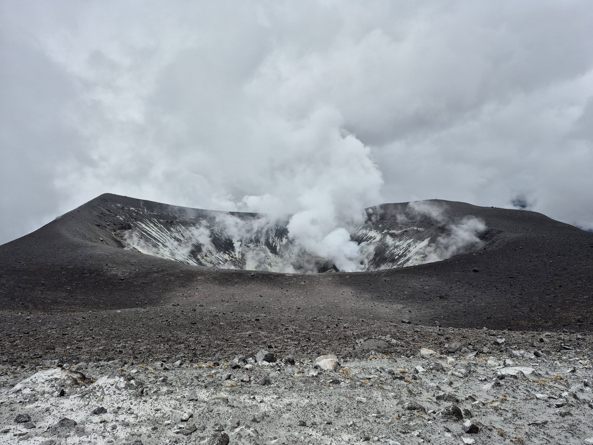
Images captured by visible and infrared webcams continued to reveal degassing processes and thermal anomalies within the Puracé crater and in the fumarole field on the outer rim of the crater, respectively.
In conclusion, continued degassing from the Puracé crater continued throughout the week, accompanied by moderate SO₂ and CO₂ emissions, with seismic activity located south of the Puracé crater and slow ground deformation, indicating the persistence of an active volcanic system.
Based on the above, the SGC recommends closely monitoring the evolution of volcanic activity through weekly and special bulletins, in addition to information published through official channels, and following the instructions of local and departmental authorities and the National Disaster Risk Management Unit (UNGRD). The alert status for volcanic activity remains yellow: active volcano showing changes in the behavior of the base level of monitored parameters and other manifestations.
Source et photo : SGC
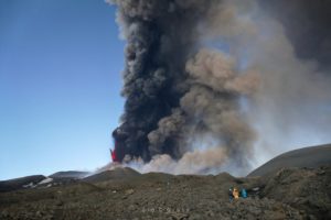
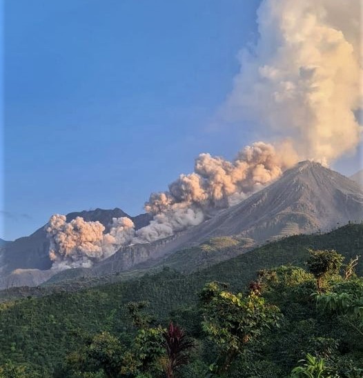
Guatemala , Santiaguito :
Activity
Continuous white degassing is observed above Caliente Dome, with fumaroles rising up to 400 meters and dispersing southwestward. Lava extrusion continues, accumulating material on the dome and on the lava flow on the west-southwest flank. Two to three explosions per hour are also recorded, generating ash columns reaching 900 meters high, dispersing towards Loma Linda, San Marcos, and neighboring communities. During the night and early morning, intense incandescence was recorded in the crater, accompanied by collapses and the fall of incandescent blocks on its flanks.
Given the high level of activity and the risk of major collapses, the generation of pyroclastic flows over long distances, regardless of direction, cannot be ruled out. In addition, rainfall may mobilize material accumulated in ravines and channels, causing lahars in the afternoon and at night. It is recommended to avoid ravines and riverbeds during and after rains, and to strictly follow the instructions in special bulletin BESAN-002-2025.
Source : Insivumeh
Photo : Edgar Cabrera / CONRED (archive 2022)