July 16 , 2025.
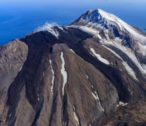
Italy / Sicily , Etna :
WEEKLY BULLETIN, from July 7, 2025 to July 13, 2025. (Publication date: July 15, 2025)
ACTIVITY SUMMARY
Based on monitoring data, the following elements are highlighted:
1) VOLCANOLOGICAL OBSERVATIONS: Degassing activity at variable rates in the summit craters.
2) SEISMOLOGY: Absence of seismic activity due to fracturing with Ml >=2.0. Tremor amplitude at low levels.
3) INFRASOUND: Low infrasound activity.
4) GROUND DEFORMATION: Ground deformation monitoring networks have not recorded any significant variations.
5) GEOCHEMISTRY: SO2 flux at low levels. Soil CO2 fluxes (EtnaGas Network): low values.
Dissolved CO2 in groundwater (EtnaWater Network): no update.
Helium isotope ratio at peripheral sites: no update; the latest data were at average values (June 4).
6) SATELLITE OBSERVATIONS: Thermal activity observed by satellite in the summit area was generally low.
VOLCANOLOGICAL OBSERVATIONS
Monitoring of Mount Etna’s volcanic activity was carried out through image analysis from the INGV’s surveillance camera network, Osservatorio Etneo (INGV-OE), and two inspections of the crater area.
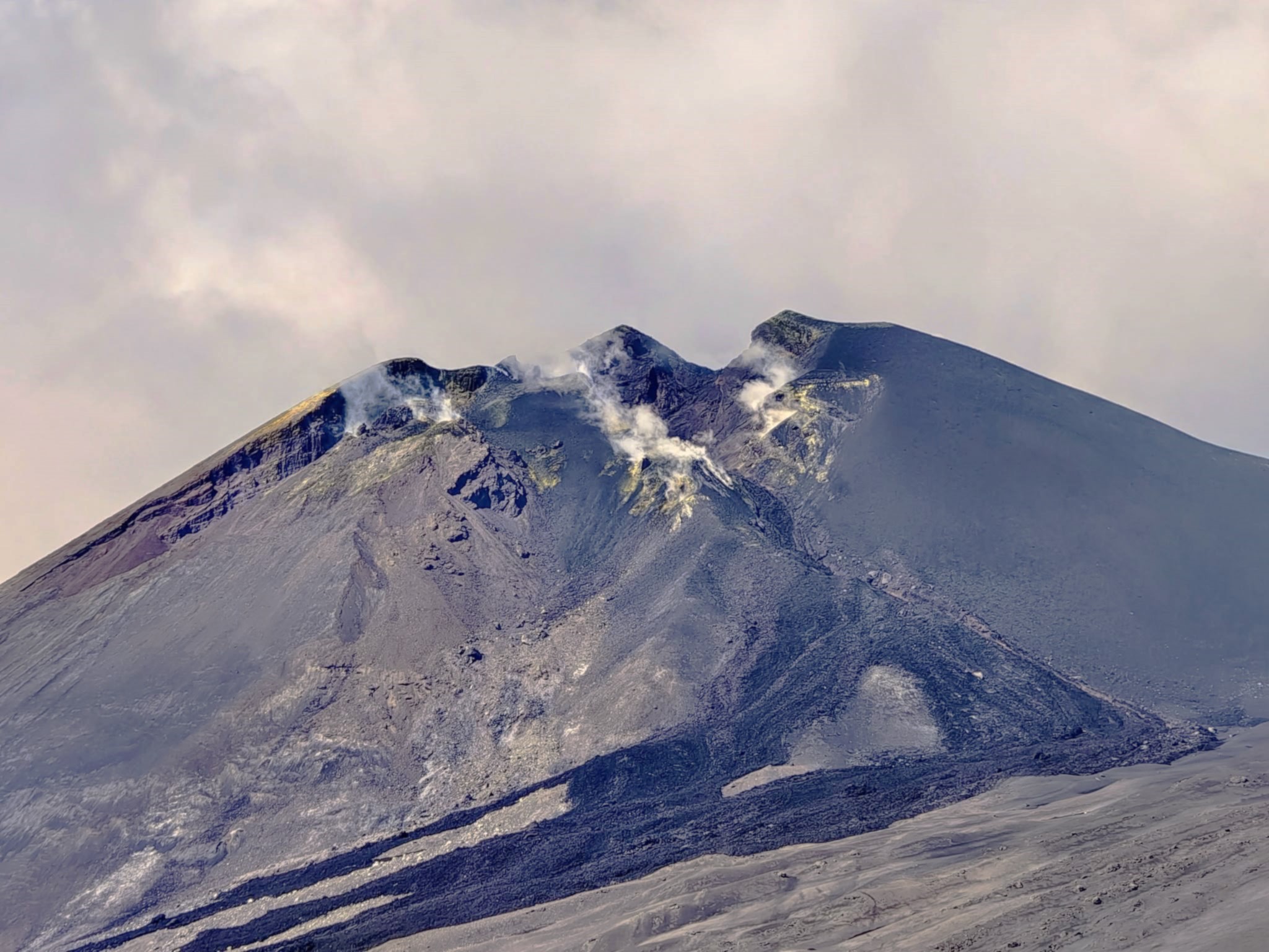
Overall, during the week under review, the summit craters were affected by degassing at varying rates within each crater. The Northeast Crater, in particular, was affected by intense degassing generated by a vent located on the crater floor. The other craters, on the other hand, exhibited less extensive degassing, mainly related to various fumarole systems, while the Bocca Nuova Crater exhibited degassing generated primarily by the BN1 crater. During the surveys, it was possible to observe that the BN2 crater of Bocca Nuova gradually widened along the northeastern flank of the crater rim.
Source : INGV
Photo : Thor Luculus
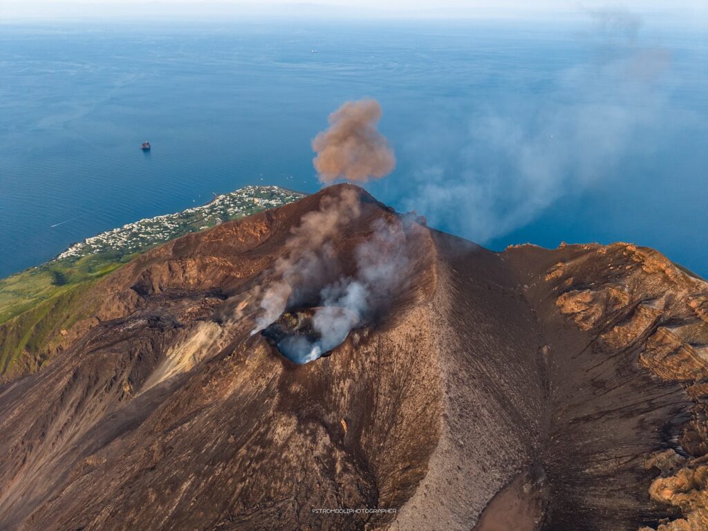
Italy , Stromboli :
WEEKLY BULLETIN, from July 7, 2025 to July 13, 2025. (Publication date: July 15, 2025)
SUMMARY OF ACTIVITY STATUS
Based on monitoring data, the following are highlighted:
1) VOLCANOLOGICAL OBSERVATIONS: Ordinary eruptive activity with frequency and intensity of low-level Strombolian explosions in the North and South-Central crater areas.
2) SEISMOLOGICAL OBSERVATIONS: The monitored seismological parameters show no significant changes.
3) GROUND DEFORMATION: Ground deformation monitoring networks have not shown any significant changes.
4) GEOCHEMICAL OBSERVATIONS: Low-level SO2 fluxes. High levels of CO2 fluxes from the soil in the Pizzo area (STR02). C/S ratio in the plume: average values.
Dissolved helium isotope ratio (R/Ra) in the thermal aquifer: data from June 17 were high.
Soil CO2 flux in the Scari area: average to high values.
5) SATELLITE OBSERVATIONS: Thermal activity observed by satellite in the summit area was generally low.
VOLCANOLOGICAL OBSERVATIONS
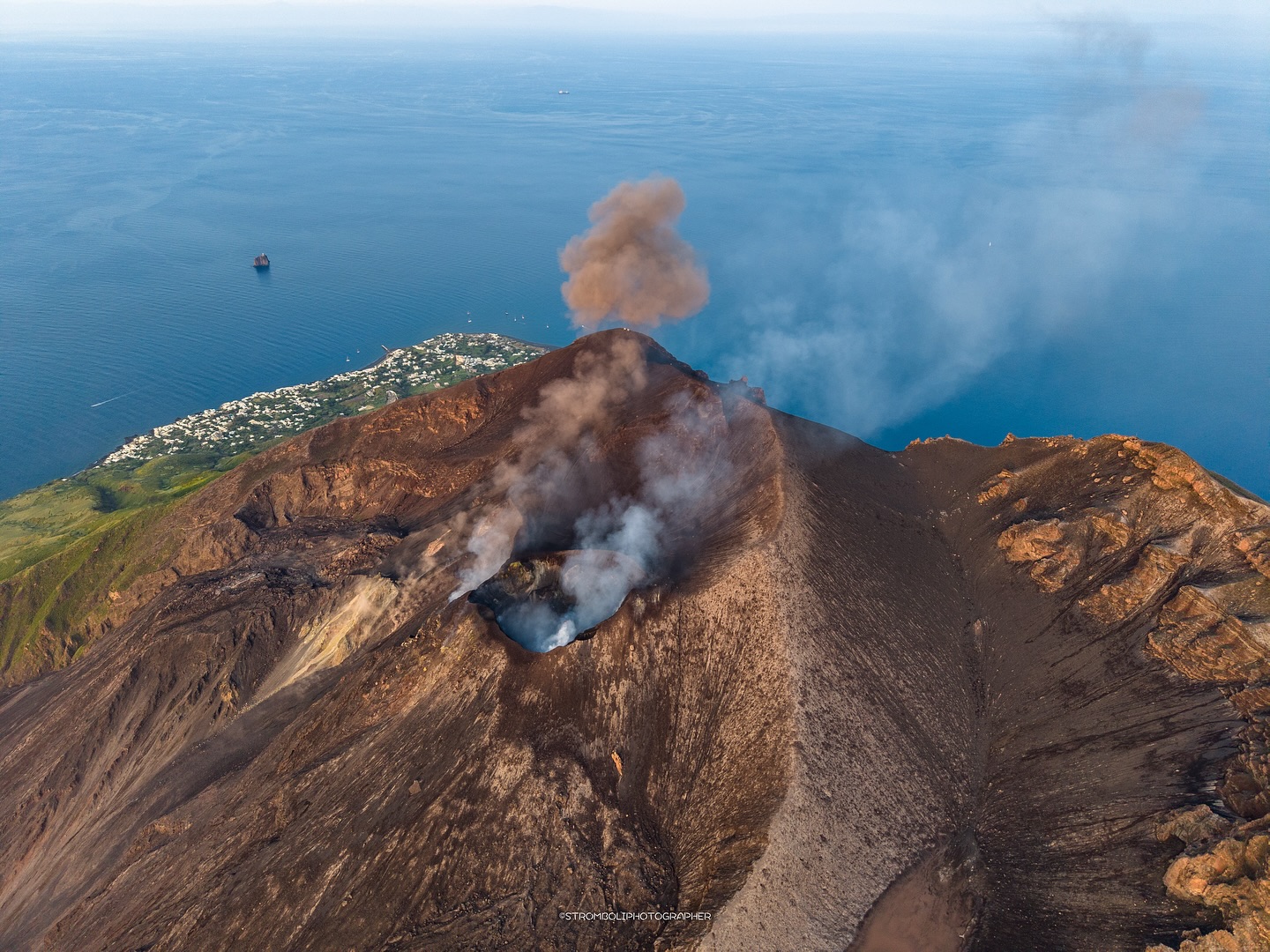
During the observation period, Stromboli’s eruptive activity was characterized by analyzing images recorded by INGV-OE surveillance cameras located at an altitude of 190 m (SCT-SCV) and at Punta dei Corvi (SPCT). Explosive activity was mainly produced by four eruptive vents located in the North Crater area and by at least two vents located in the Central-South Crater area.
The eruptive activity observed in the North Crater area was produced by four active vents, with eruptive products consisting mainly of coarse materials (bombs and lapilli). The explosions were of low intensity (the eruptive products reached a height of less than 80 m) and sometimes of medium intensity (product heights between 80 and 150 m). The average explosion frequency ranged between 5 and 10 events per hour. Between 10 and 11 July, low and irregular explosive activity was observed in the N1 sector. In the Centre-South (CS) area, explosive activity was absent for most of the observed period, and only a few low-intensity explosions with fine particle emission were observed. The average explosion frequency ranged between 0 and 1 event per hour.
Source : INGV
Photo : Stromboli , Stromboli stati d’animo / Sebastiano Cannavo
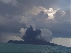
Iceland , Reykjanes Peninsula :
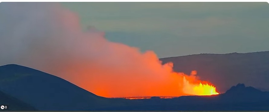
An eruption has started on Sundhnúksgígaröð crater row , July 16 , 2025.
Updated at 3:56
An eruption has started. The location is southeast of Litla-Skógfell.
Updated at 3:10
The earthquake activity is more intense north of the area where the swarm started.
Updated at 2:25
The earthquakes in the seismic swarm are mostly occurring at 4 to 6 km depth. That indicates that magma is not moving towards the surface at this point.
Updated at 2:11
According to seismicity and real time GNSS data the dike forming below the Sundhnúksgígar crater row is moving southwards rather than north.
Updated at 01:55
According to real time GNSS data the deformation is still minor indicating that the seismicity is still small compared to previous events.
Updated at 01:20
Intense seismic swarm has started on the Sundhnúkur Crater Row and monitoring data
Intense seismic swarm has started on the Sundhnúksgígar Crater Row and monitoring data is indicating that an dike intrusion has started. The likelihood of an eruption remains high while the intrusion is ongoing.
The seismicity is located between Stóra-Skógfell and Sýlingarfell, a similar location as previous dike intrusion started on the Sundhnúksgígar Crater Row.
Source : IMO.
Photo : via Mike Schuler / FB.
Indonesia , Marapi :
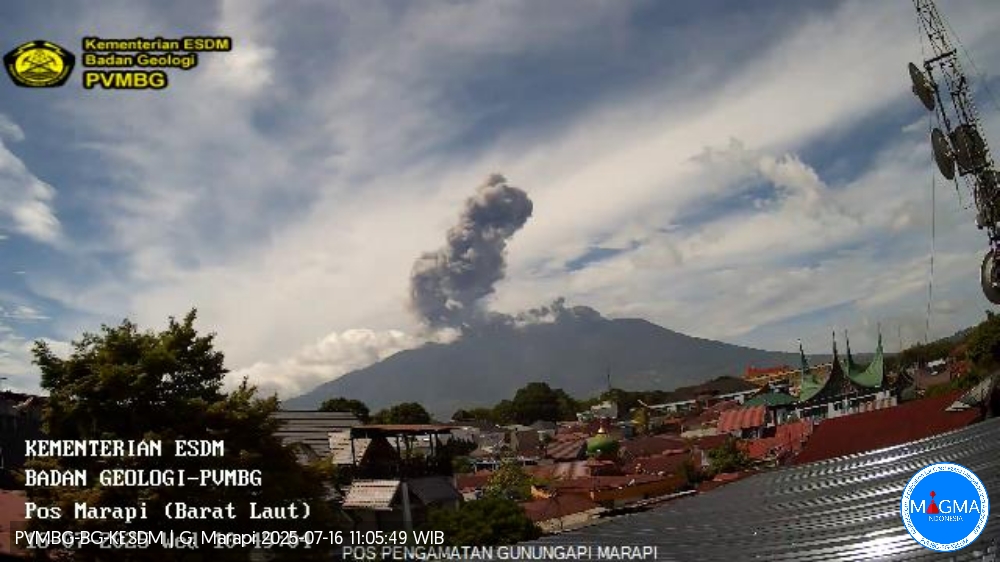
Mount Marapi erupted on Wednesday, July 16, 2025, at 10:42 a.m. (local time). An ash column was observed about 1,200 m above the summit (about 4,091 m above sea level). The ash column was gray and of strong intensity, oriented northeast. At the time of writing, the eruption was still ongoing.
VOLCANO OBSERVATORY NOTICE FOR AVIATION – VONA
Issued : July 16 , 2025
Volcano : Marapi (261140)
Current Aviation Colour Code : YELLOW
Previous Aviation Colour Code : yellow
Source : Marapi Volcano Observatory
Notice Number : 2025MAR055
Volcano Location : S 0 deg 22 min 52 sec E 100 deg 28 min 23 sec
Area : West Sumatra, Indonesia
Summit Elevation : 9251 FT (2891 M)
Volcanic Activity Summary :
Increasing in volcanic activity.
Volcanic Cloud Height :
Best estimate of ash-cloud top is around 13091 FT (4091 M) above sea level or 3840 FT (1200 M) above summit. May be higher than what can be observed clearly. Source of height data: ground observer.
Other Volcanic Cloud Information :
Ash cloud moving to northeast. Volcanic ash is observed to be gray. The intensity of volcanic ash is observed to be thick.
Remarks :
Eruption and ash emission is continuing. Eruption recorded on seismogram with maximum amplitude 30.5 mm. Tremor recorded on seismogram with maximum amplitude 2.5 mm.
Source et photo : Magma Indonésie .
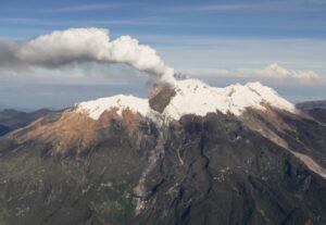
Chile , Planchón-Peteroa :
Special Volcanic Activity Report (REAV), Maule Region, Planchón-Peteroa Volcanic Complex, July 15, 2025, 4:40 p.m. local time (Continental Chile).
The National Geology and Mining Service of Chile (Sernageomin) publishes the following information, obtained using the monitoring equipment of the National Volcanic Monitoring Network (RNVV), processed and analyzed at the Southern Andean Volcanological Observatory (OVDAS):
Since July 13, a significant increase in seismicity associated with volcanic fluid dynamics has been observed, characterized by the occurrence of long-period (LP) earthquakes and tremor pulses (TR). Since then, more than 1,200 seismic events have been classified, each considered weak. This increase in activity is part of an evolving process since March, initially characterized by an increase in VT (volcano-tectonic) type seismicity, located mainly under the volcanic edifice with low magnitudes, generally less than 2.0.

Subsequently, on June 19, a tremor pulse was recorded, the characteristics of which suggest a deep source, marking a change in the system’s dynamics.
In recent days, the process has shifted toward a predominance of LP-type seismicity, consistent with greater involvement of surface fluids. The characteristics of these earthquakes and their temporal evolution suggest activation of the surface hydrothermal system, likely due to physicochemical changes resulting from the mobilization of higher-temperature fluids.
Given the above, the possibility that the process could continue and lead to smaller explosions and/or ash emissions, as occurred during previous eruptive cycles of this volcanic system, cannot be ruled out. As previously noted, significant volcanic seismic activity associated with fluid dynamics is also recorded. Other aspects of surface activity, assessed using fixed cameras and remote sensors available on specialized websites, remain unchanged to date.
Despite the presence of this seismic activity and its low energy, the technical alert for this volcanic system remains green, and analysis of the process continues.
Source et photo : Sernageomin.