July 8 , 2025.
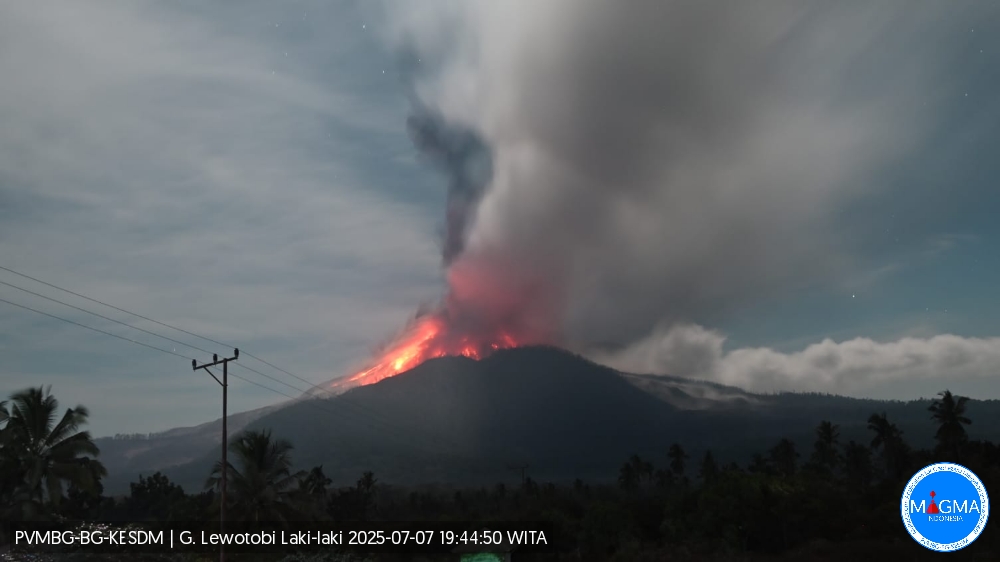
Indonesia , Lewotobi Laki Laki :
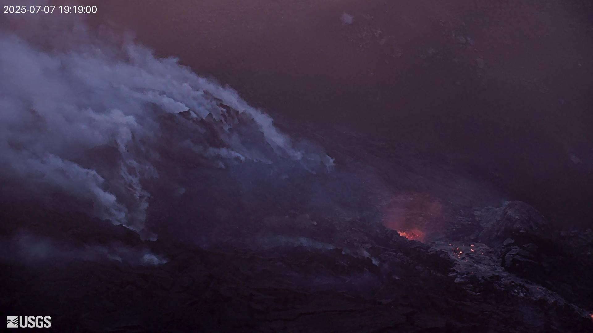
An eruption of Mount Lewotobi Laki-laki occurred on Monday, July 7, 2025, at 7:31 PM WITA. The observed ash column was ± 13,000 m above the summit (± 14,584 m above sea level). The ash column was gray to black in color, with strong intensity, oriented toward the west and northwest. At the time of this report, the eruption was still ongoing.
VOLCANO OBSERVATORY NOTICE FOR AVIATION – VONA
Issued : July 7 , 2025
Volcano : Lewotobi Laki-laki (264180)
Current Aviation Colour Code : RED
Previous Aviation Colour Code : red
Source : Lewotobi Laki-laki Volcano Observatory
Notice Number : 2025LWK348
Volcano Location : S 08 deg 32 min 20 sec E 122 deg 46 min 06 sec
Area : East Nusa Tenggara, Indonesia
Summit Elevation : 5069 FT (1584 M)
Volcanic Activity Summary :
Eruption with volcanic ash cloud at 11h31 UTC (19h31 local).
Volcanic Cloud Height :
Best estimate of ash-cloud top is around 46669 FT (14584 M) above sea level or 41600 FT (13000 M) above summit. May be higher than what can be observed clearly. Source of height data: ground observer.
Other Volcanic Cloud Information :
Ash cloud moving from west to northwest. Volcanic ash is observed to be gray to dark. The intensity of volcanic ash is observed to be thick.
Remarks :
Eruption recorded on seismogram with maximum amplitude 47.3 mm and maximum duration 117 second.
A major explosive eruption occurred at Mount Lewotobi Laki-laki, located on Flores Island, Indonesia, at 11:05 WITA (03:05 UTC) on July 7.
Indonesia’s Geological Agency (Badan Geologi) reported that pyroclastic flows, an avalanche of hot gas clouds, mixed with rocks and lava, traveled up to 5 km (3 miles) down the slopes of the volcano during the eruption. Pyroclastic flows pose extreme hazards due to their speed, heat, and force, and can destroy anything in their path.
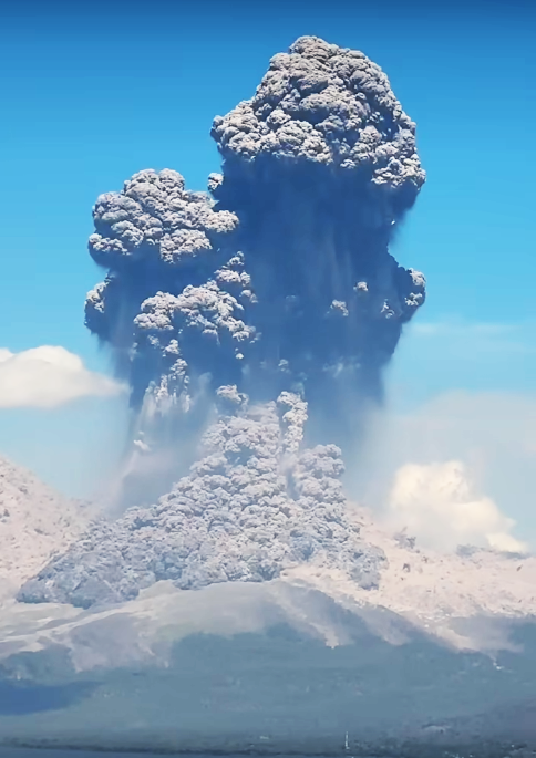
The Volcanology and Geological Hazard Mitigation Center (PVMBG) reported an ash column height of approximately 18 km (59 000 feet) above the summit or about 19.6 km (63 000 feet) a.s.l. This is the highest ash column at Laki-laki since the November 2024 eruption, which killed nine people and injured dozens.
The ash plume was observed as gray to black in color with thick intensity, spreading toward the north, northeast, and northwest, affecting villages downwind. Residents are being warned to wear masks or cover their mouths due to ash exposure.
This marks the volcano’s third major eruptive phase in 2025, following events in March and May. The current eruption prompted aviation warnings and the cancellation of multiple flights between Australia and Indonesia. Airlines, including Virgin Australia, Jetstar, and Qantas, suspended routes to and from Bali due to the high-altitude ash hazard.
Authorities have maintained the highest alert level (Level IV) since the May eruption and continue to enforce a 7 km (4.3 miles) exclusion zone around the crater.
No casualties or infrastructure damage have been reported as of the latest updates. However, residents and local officials were advised to remain vigilant due to the potential for secondary hazards such as lahars, especially during periods of heavy rainfall.
Sources : Magma Indonésie , weathercompass gr .
Photos : Magma Indonésie , Rahay Mua Maumere ( capture d’écran) .
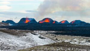
Hawaii , Kilauea :
Monday, July 7, 2025, 9:27 AM HST (Monday, July 7, 2025, 19:27 UTC)
19°25’16 » N 155°17’13 » W,
Summit Elevation 4091 ft (1247 m)
Current Volcano Alert Level: WATCH
Current Aviation Color Code: ORANGE
Activity Summary:
The ongoing Halemaʻumaʻu eruption is paused. The end of episode 27 on June 29 coincided with a switch from deflationary tilt to inflationary tilt at the summit and a decrease in seismic tremor intensity. Summit inflation continues at this time, along with persistent, low-level seismic tremor in association with gas piston cycles at the eruptive vent(s). Incandescent glow has been visible at the north vent in overnight webcam views, as well as intermittent minor lava spattering and jetting. These observations indicate that another lava fountaining episode is probable, and the current summit inflation rate suggests it will occur sometime between July 8 and 10, with July 8–9 (Tuesday–Wednesday) being the most likely. This window is subject to change due to variations in the summit inflation rate and other factors, and it will be refined as more data become available.
Fountaining episodes have occurred approximately once per week since the start of the current eruption on December 23, 2024. All eruptive activity remains within Hawaiʻi Volcanoes National Park, and no significant activity has been noted along Kīlauea’s East Rift Zone or Southwest Rift Zone.
Summit Observations:
At the north vent in Halemaʻumaʻu within the western part of Kaluapele (Kīlauea caldera), incandescent glow has been visible in overnight webcam views since shortly after episode 27. Additionally, intermittent minor lava spattering and jetting has been observed at the same location the past few nights.
The tiltmeter near Uēkahuna (UWD) has recorded approximately 14 microradians of inflationary tilt since the end of episode 27. UWD recorded more than 16 microradians of deflationary tilt during the fountaining episode. Seismic tremor persists at low levels beneath Halemaʻumaʻu crater in association with gas piston cycles at the eruptive vent(s) .
Vigorous degassing continues from both the north and south vents. The typical sulfur dioxide (SO2) emission rate during inter-episode pauses, such as the current pause, is around 1,200 tonnes/day.
Source et photo : HVO
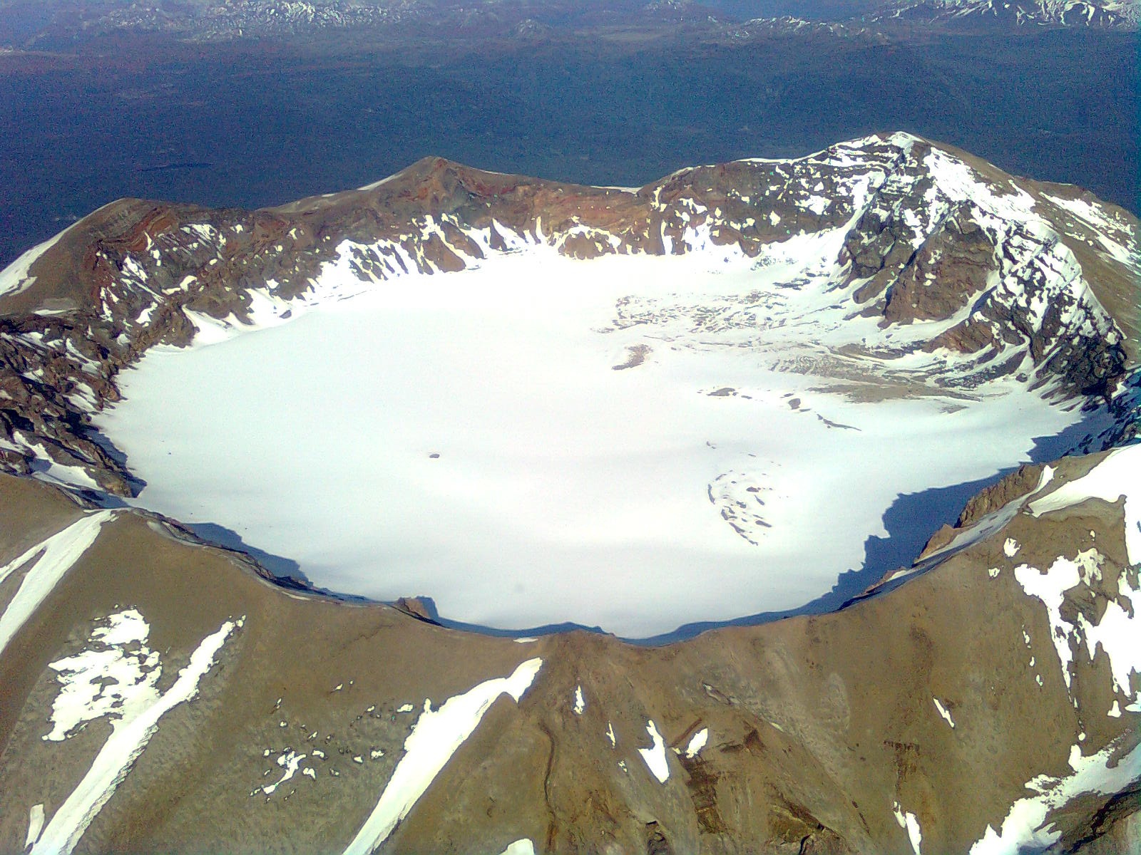
Chile , Puyehue / Cordon Caulle :
Seismology
Seismological activity during this period was characterized by the following:
232 VT-type earthquakes, associated with rock fracturing (volcano-tectonics). The most energetic earthquake, with a local magnitude (LM) of 2.2, was located 4.3 km south-southwest and at a depth of 6 km from the 2011 emission center.
One LP-type earthquake, associated with fluid dynamics within the volcanic system (long period). The size of the largest earthquake, estimated using the reduced displacement (RD) parameter, was 6.3 cm².
One TO-type earthquake, associated with fluid dynamics within the volcanic system, characterized by its distinctive waveform (tornillo). The size of the earthquake (RD) was 15.3 cm².
Fluid Geochemistry
No anomalies in atmospheric sulfur dioxide (SO2) emissions have been reported near the volcanic complex, according to data published by the Tropospheric Monitoring Instrument (TROPOMI) and the Sulfur Dioxide Group of the Ozone Monitoring Instrument (OMI).
Geodesy
During the period analyzed, geodetic activity was characterized by the following aspects:
– High horizontal deformation rates recorded along the monitoring lines (distance between GNSS stations), reaching values of up to 1.5 cm/month. These values are considered significant and are directly related to the active inflationary process in the northeast sector of the graben, an area close to the 2011 emission center.
– High vertical deformation rates observed at GNSS stations, exceeding 2.0 cm/month.
Although one station displays an even higher rate, its data present distortions attributable to adverse weather and atmospheric conditions, as well as intermittent GNSS signal losses. However, this does not compromise the overall interpretation of the inflationary process, which continues with a similar trend to that recorded in previous periods. Significant deflationary processes were also identified, with negative vertical rates exceeding -2.0 cm/month at stations located in the area associated with the 2011 emission center (the Laccolith area), an area that has been systematically monitored since February 2025.
GNSS data analysis allows us to infer the existence of two distinct deformation zones:
1. The northeast area of the graben, where a strong inflationary process is underway, recorded instrumentally since mid-2021.
2. The area around the 2011 emission center (laccolith), where a strong deflationary process is underway, measured instrumentally since February 2025.
These measurements and analyses highlight the continuation of high-level deformation processes within the volcanic complex.
Satellite Thermal Anomalies
During this period, low-power thermal anomalies were recorded in the area where the laccolith is located, northeast of the 2011 emission center. These anomalies recorded a maximum volcanic radiant power (VRP) of 1 MW on June 30, according to data processed by the VIIRS sensor of the MIROVA platform (Mid-Infrared Volcanic Activity Observation). Images from the Sentinel 2-L2A and Landsat 8-9 satellites did not detect any significant radiance anomalies in the volcanic complex.
During the period analyzed, the graben sector continued to exhibit inflationary deformation at a constant rate and without significant fluctuations. However, the area near the 2011 emission center, and more specifically the area influenced by the presence of the surface magmatic body (laccolith), underwent deflation. This deformation process was accompanied by activity. Low-energy seismic activity, the variations of which remained within the system’s normal limits. Therefore, the volcanic system continues to be active above its base level, and the YELLOW Technical Alert remains in effect.
YELLOW TECHNICAL ALERT: Changes in the behavior of volcanic activity
Source : Sernageomin.
Photo : Sergio Osses
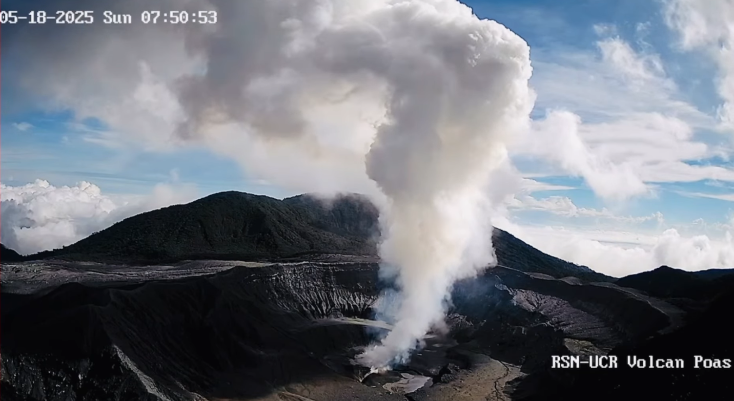
Costa Rica , Poas :
Latitude: 10.20°N;
Longitude: 84.23°W;
Altitude: 2,687 m.
Current Activity Level: Caution
Following the May 19 eruption, no further explosive events have been recorded. However, weak ash emissions were observed last week.
This week, the amplitude of the continuous seismic tremor remains low and stable compared to recent months. The acoustic tremor, originating from Vent A, remains generally stable. The number of long-period events has decreased compared to last week. This week, 17 volcano-tectonic events were recorded, most of them very close together on the northwest flank of the von Frantzius cone, at depths between 4 and 5 km below sea level. Three of these events had a magnitude greater than 2.3.
In recent weeks, the crater’s uplift and expansion have ceased, and to date, no significant crustal deformation has been observed on the geodetic network. The average SO2 flux this week was 441 ± 74 t/d, a slight increase compared to the previous week (352 ± 48 t/d). The mass of SO2 measured in the Costa Rican atmosphere by the TROPOMI sensor on the Sentinel-5P satellite decreased significantly this week, with sporadic detections following a peak of 1,237 tons of SO2 recorded on June 27.
The MultiGAS station located near Boca A measured an average SO2/CO2 ratio of 2.1 ± 0.8 this week, slightly higher than the previous week’s (1.5 ± 0.7). The H2S/SO2 ratio has remained very low (< 0.1) in recent weeks. The gases are believed to be coming from a surface magmatic source.
The level of the new Boca C lake stabilized this week, meaning that the inflows due to degassing and precipitation are in balance with losses due to evaporation and infiltration. The lake’s temperature was measured remotely with a portable infrared thermograph, recording just over 70°C, and Boca C reached as high as 845°C.
Source : Ovsicori .
Photo : Archive RSN-UCR.
Guatemala , Santiaguito :
Activity
White outgassing is observed above the Caliente dome, at an altitude of 500 m, dispersing westward. Weak and moderate explosions are also generated, generating ash clouds at an altitude of 900 m above the Caliente dome, also dispersing westward. During the night and early morning, incandescent blocks can be observed descending on different flanks of the volcano.
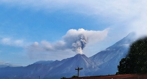
Due to the high activity of the Santiaguito volcano, the formation of pyroclastic flows over long distances and in different directions cannot be ruled out. Therefore, the recommendations of Special Bulletin BESAN-002-2025 should be followed. During the rainy season, lahars can descend along various channels of the volcano; it is therefore recommended to avoid staying near watercourses in the afternoon and evening.
Source : Insivumeh .
Photo : Conred .