June 03 , 2025.
Italy / Sicily , Etna :
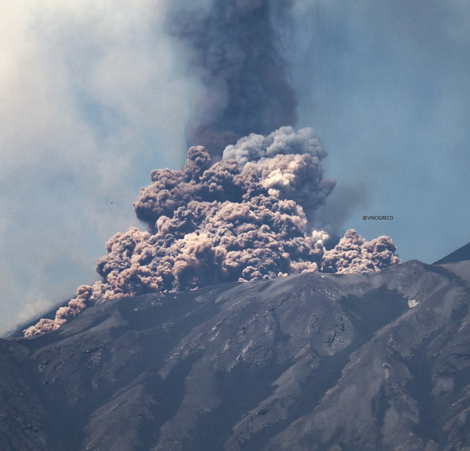
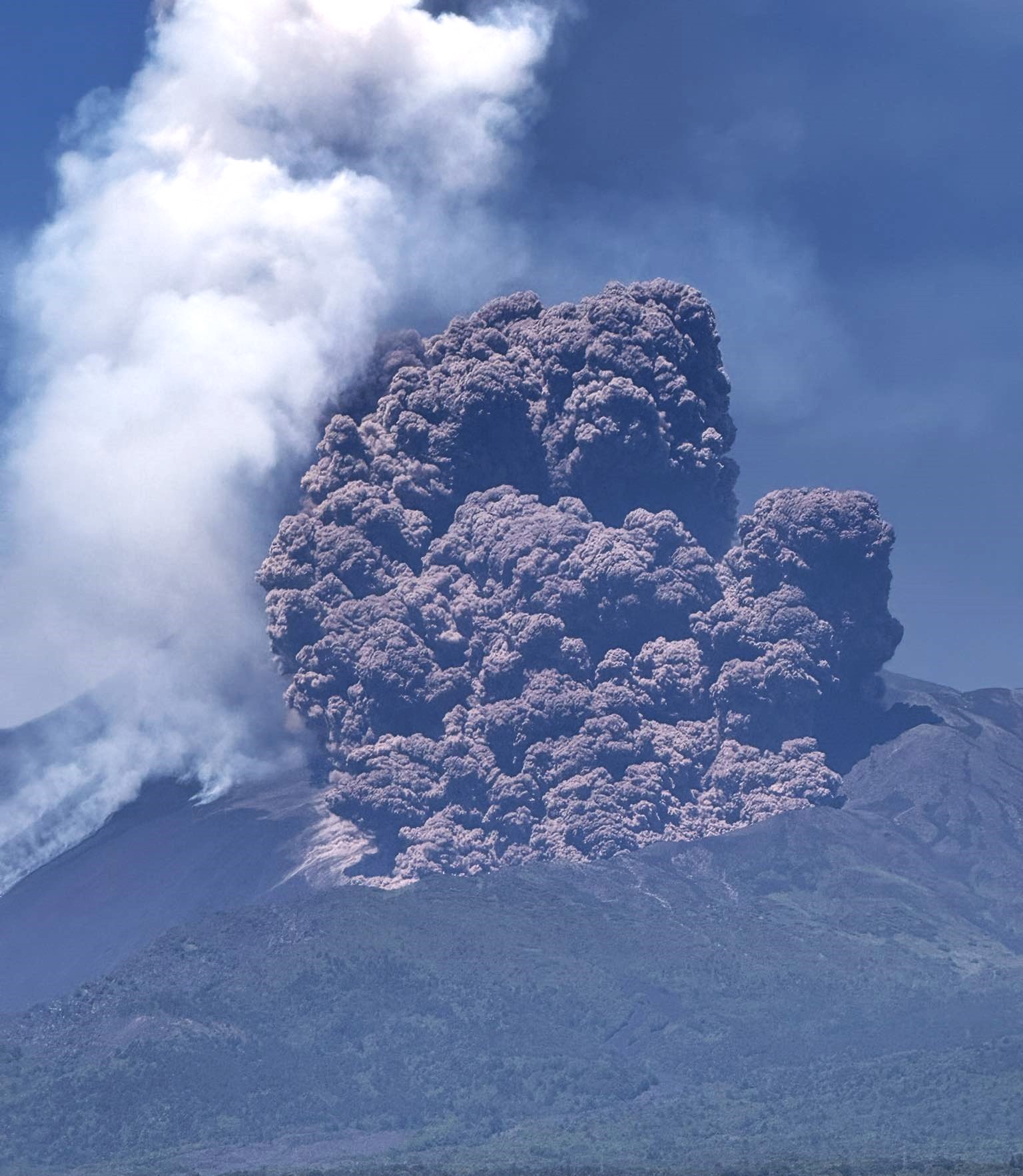
Etna Activity Report, June 2, 2025, 11:03 (09:03 UTC).
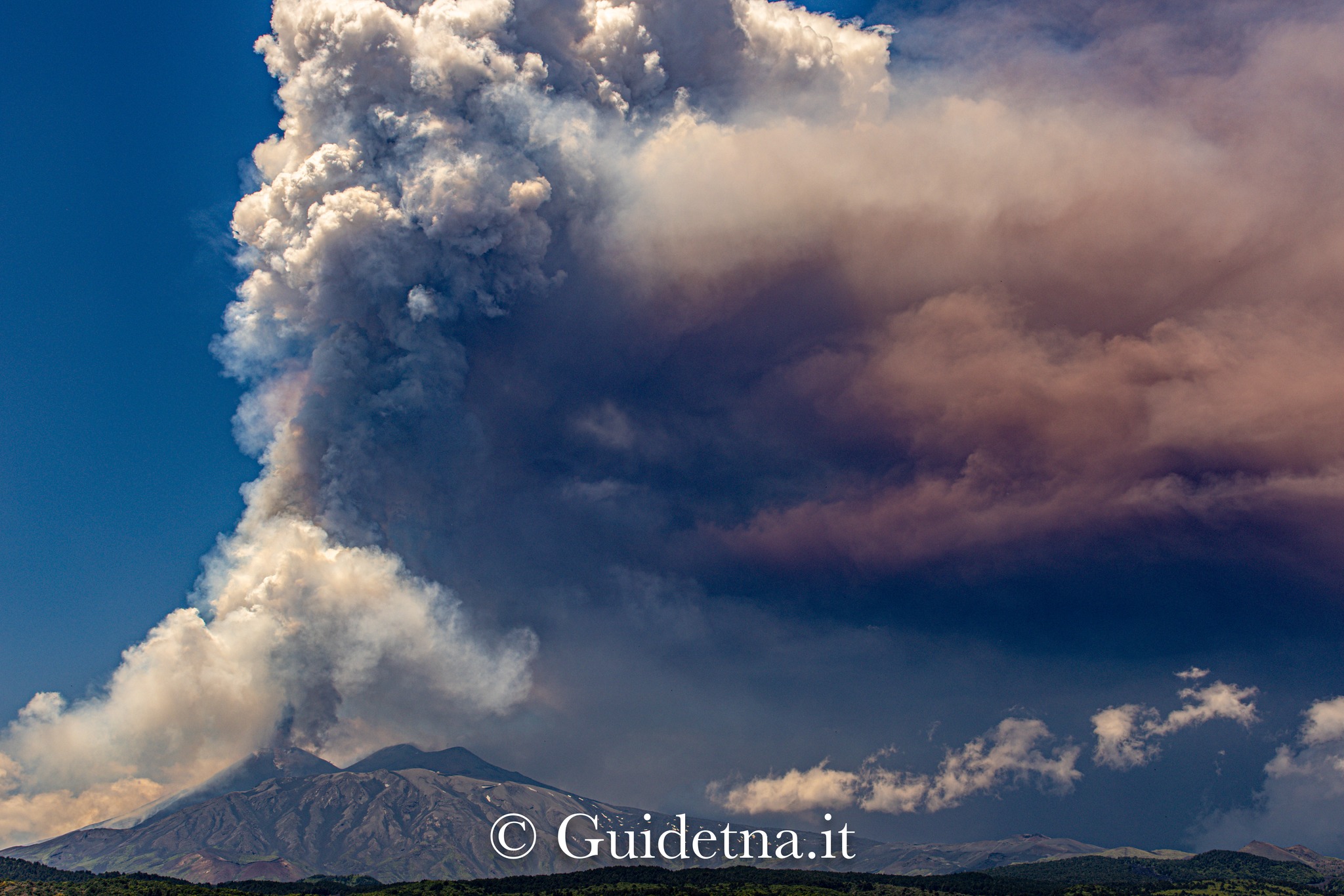
The National Institute of Geophysics and Volcanology, Osservatorio Etneo, reports that over the past few hours, the eruptive activity reported in the 02:14 UTC report has continued, with Strombolian explosions of increasing intensity, currently at high intensity and almost continuous. In recent hours, ashfall has been reported in the Piano Vetore area. This activity is fueling a slight lava overflow from the southern rim of the southeast crater and a modest lava flow toward the Valle del Bove. The forecast model indicates that an eruptive cloud produced by the ongoing activity would disperse in a west-southwest direction.
From a seismic perspective, tremor amplitude values are currently high and tend to increase. The center of gravity of the tremor sources is located in the Southeast Crater area, at an altitude of approximately 2,800 m above sea level. Infrasound activity is high, both in terms of frequency and energy, for events located in correspondence with the Southeast Crater. Regarding ground deformation, a stress variation of approximately 25 nanostrains was observed at the DRUV station starting at 01:50 UTC. Other deformation monitoring networks do not show significant variations.
Mount Etna Activity Statement, June 2, 2025, 11:35 (09:35 UTC).
The National Institute of Geophysics and Volcanology, Osservatorio Etneo, reports pyroclastic flows observed by thermal cameras.
Statement on Etna activity, June 2, 2025, 12:00 PM (10:00 UTC).
The National Institute of Geophysics and Volcanology, Osservatorio Etneo, reports that images from the monitoring system cameras show, at 9:24 UTC, a pyroclastic flow likely produced by a collapse of material on the northern flank of the Southeast Crater. According to preliminary observations, the hot material does not appear to have extended beyond the rim of the Valle del Leone. At the same time, explosive activity in the Southeast Crater has resulted in lava fountaining.
Volcanic tremor has reached very high values, with the source centroid located in the southeast crater area. Infrasound activity is also high, with events located in correspondence with the southeast crater.
The deformation signal from the DRUV station continues the variation trend that began with activity. Other deformation monitoring networks show no significant changes.
Press release on Mount Etna activity, June 2, 2025, 8:28 PM (18:28 UTC).
The National Institute of Geophysics and Volcanology, Osservatorio Etneo, announces the end of the activity described in the previous press release at 9:55 UTC. The explosive activity of the Southeast Crater generated three main lava flows: one towards the south, a second towards the east (branching into several arms), and the last, originating at the base of the northern flank of the Southeast Crater, towards the north. All flows are currently cooling. The pyroclastic flow has propagated towards the northeast, reaching the northern wall of the Valle del Bove. Ground surveys will be carried out in the coming days to map the deposit. The fine reddish material produced by the pyroclastic flow was transported by high-altitude winds and dispersed towards the west-northwest. Fallout has been reported at Cesarò and Bronte. Sporadic ash emissions are currently being observed from the Northeast Crater, scattered throughout the summit area. From a seismic point of view, the tremor returned to low values, although showing some oscillations compared to the average values.
The centroid of the tremor sources is located in the central crater area, at an altitude of approximately 2,500 m above sea level. Infrasound activity is modest, and the events are located in correspondence with the central craters.
Ground deformation signals showed a total tilt variation of approximately 0.20 microradians at the Punta Lucia summit station and a stress variation of approximately 120 nanostrains at the Monte Ruvolo station. Currently, the deformation trend appears to have exhausted itself. No significant variations are detected in the GNSS data.
Updates will be provided shortly.
Source : INGV.
Photos : Vincenzo Greco / FB , Roberta Tartoni / FB , Guide Alpine Vulcanologiche Etna / FB.
United – States , Yellowstone :
Monday, June 2, 2025, 11:04 AM MDT (Monday, June 2, 2025, 17:04 UTC)
44°25’48 » N 110°40’12 » W,
Summit Elevation 9203 ft (2805 m)
Current Volcano Alert Level: NORMAL
Current Aviation Color Code: GREEN
Summary
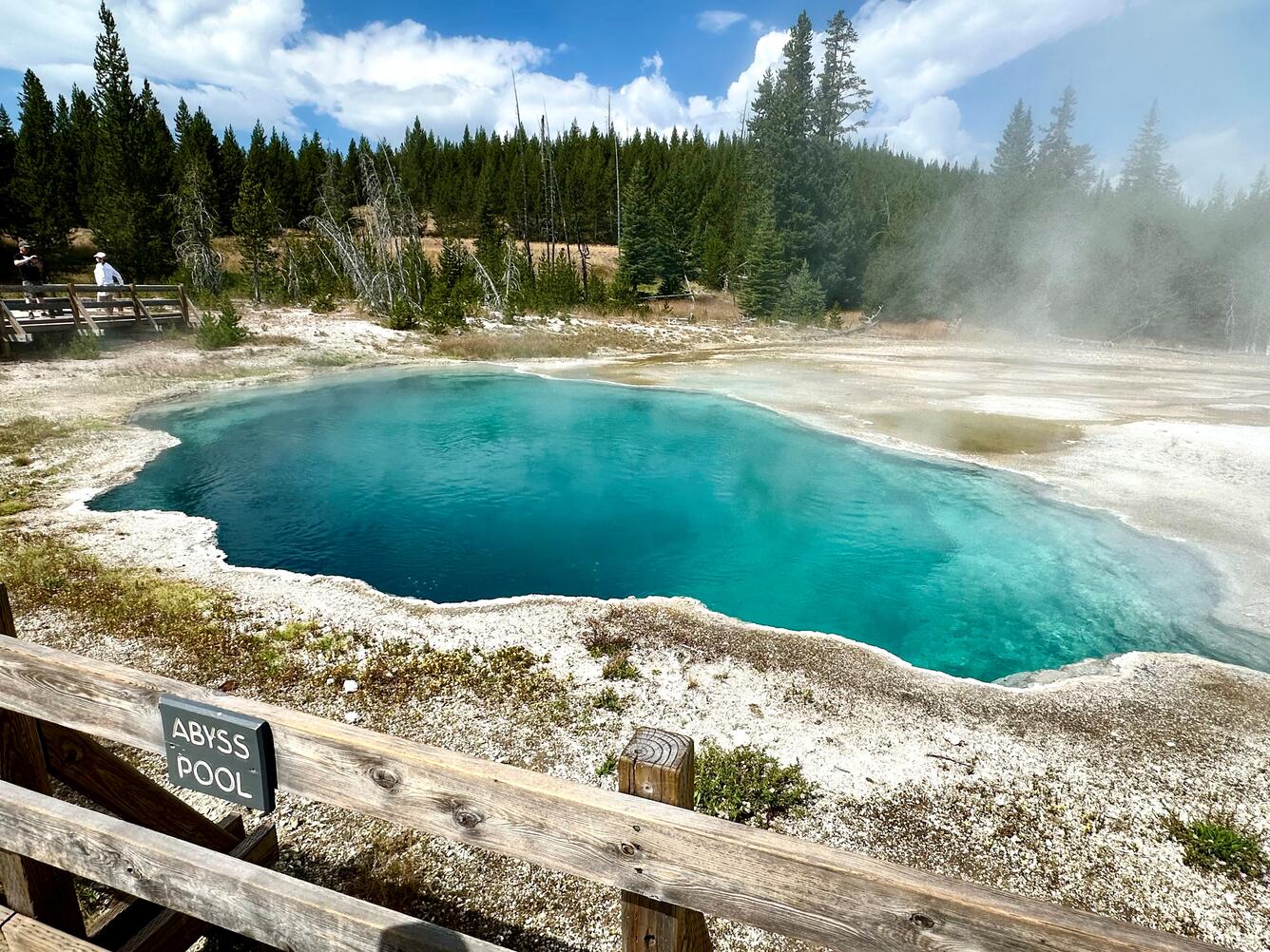
Yellowstone Caldera activity remains at background levels, with 119 located earthquakes in May (largest = M2.7). Deformation measurements indicate a small amount of caldera subsidence since early October. On May 31 at 8:39 p.m. MDT a small eruption occurred at Black Diamond Pool in Biscuit Basin, site of a hydrothermal explosion last summer. The event was recorded by a new webcam installed earlier in May.
Recent Work and News
Very little activity has occurred at Steamboat Geyser since its most recent eruption on April 14. This suggests it may still be at least several weeks before the geyser’s next major eruption.
On May 14, a new webcam was installed at Biscuit Basin to track activity at Black Diamond Pool, where a hydrothermal explosion occurred last summer. The camera posts a static image every 15 minutes . Analysis of the static images indicated changes in the pool on the evening of May 31, and downloaded video captured a small eruption from the pool at 8:39 p.m. MDT. This is the first eruption from Black Diamond Pool that has been captured on video since the hydrothermal explosion on July 23, 2024, although there is evidence from other monitoring data and some eyewitnesses that sporadic eruptions have occurred several times since the July 2024 event.
During May, Yellowstone Volcano Observatory scientists deployed semi-permanent GPS stations in the region to track surface deformation. These stations are set up every spring to densify the continuous GPS network, and they are recovered in the fall before they are buried by snow. Maintenance of geophysical and temperature monitoring stations was also completed, and the new webcam was established at Biscuit Basin. Additional work that will hopefully lead to a new seismic/acoustic/GPS station at Biscuit Basin is planned for June.
Seismicity
During May 2025, the University of Utah Seismograph Stations, responsible for the operation and analysis of the Yellowstone Seismic Network, located 119 earthquakes in the Yellowstone National Park region. The largest event of the month was a micro earthquake of magnitude 2.7 located about 7 miles north of Lake in Yellowstone National Park on May 26 at 6:39 p.m. MDT.
May seismicity in Yellowstone was marked by three swarms:
1. A swarm of 36 earthquakes, located approximately 4 miles north-northeast of West Yellowstone, MT, occurred on May 7. The largest earthquake in the sequence was a magnitude 1.8 on May 7 at 5:35 a.m. MDT.
2. A swarm of 10 earthquakes occurred about 4 miles north-northeast of West Yellowstone, MT, during May 18–19. This is the same area as the swarm described above, and the largest earthquake in the sequence was a magnitude 1.5 on May 18 at 7:46 a.m. MDT.
3. A swarm of 18 earthquakes, located approximately 5 miles northeast of West Yellowstone, MT, occurred during May 12–17. The largest earthquake in the sequence was a magnitude 2.1 on May 16 at 12:04 a.m. MDT.
Yellowstone earthquake activity remains at background levels.
Ground Deformation
Continuous GPS stations in Yellowstone Caldera recorded a small amount (about 3 centimeters, or 1.2 inches) of subsidence since October. This pattern and rate of subsidence continues a trend that started in 2015–2016. Minor subsidence (about 1 centimeter, or about half an inch) was also measured by a continuous GPS station near Norris Geyser Basin since the end of last summer, although no deformation has occurred at that site over the past 2 months.
Source : YVO
Photo : Abyss Pool USGS / Pat Shanks, 2024.
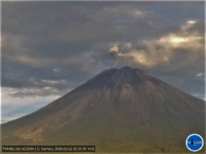
Indonesia , Semeru :
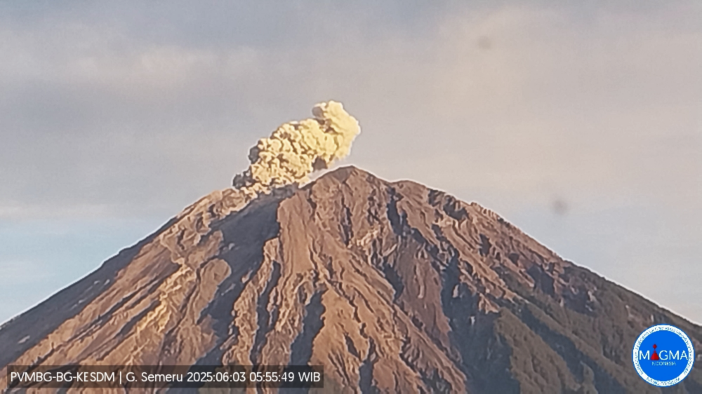
Mount Semeru erupted on Tuesday, June 3, 2025, at 5:55 a.m. WIB. The observed ash column was ± 1,000 m above the summit (± 4,676 m above sea level). The ash column was white to gray, with moderate intensity, oriented towards the north. At the time of this report, the eruption was still ongoing.
VOLCANO OBSERVATORY NOTICE FOR AVIATION – VONA
Issued : June 03 , 2025
Volcano : Semeru (263300)
Current Aviation Colour Code : ORANGE
Previous Aviation Colour Code : orange
Source : Semeru Volcano Observatory
Notice Number : 2025SMR2097
Volcano Location : S 08 deg 06 min 29 sec E 112 deg 55 min 12 sec
Area : East java, Indonesia
Summit Elevation : 11763 FT (3676 M)
Volcanic Activity Summary :
Eruption with volcanic ash cloud at 22h55 UTC (05h55 local).
Volcanic Cloud Height :
Best estimate of ash-cloud top is around 14963 FT (4676 M) above sea level or 3200 FT (1000 M) above summit. May be higher than what can be observed clearly. Source of height data: ground observer.
Other Volcanic Cloud Information :
Ash cloud moving to north. Volcanic ash is observed to be white to gray. The intensity of volcanic ash is observed to be medium.
Remarks :
Eruption recorded on seismogram with maximum amplitude 22 mm and maximum duration 101 second.
Source et photo : Magma Indonésie .
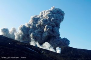
Ecuador , El Reventador :
DAILY STATUS REPORT OF REVENTADOR VOLCANO, Monday, June 2, 2025.
Information Geophysical Institute – EPN.
Surface Activity Level: High, Surface Trend: No change
Internal Activity Level: Moderate, Internal Trend: No change
From June 1, 2025, 11:00 a.m. to June 2, 2025, 11:00 a.m.:
Seismicity:
Below is the count of seismic events recorded at the reference station.
Explosion (EXP) 120
Long Period (LP) 13
Emission Tremor (TREMI) 22
Harmonic Tremor (TRARM) 5
Rainfall/Lahars:
Light rainfall was recorded in the volcano area last night and early this morning, according to surveillance cameras and meteorologists. **If heavy rainfall occurs in the region, it could remobilize accumulated material and generate mud and debris flows that would descend the volcano’s flanks and flow into downstream rivers.
Emission/Ash Column:
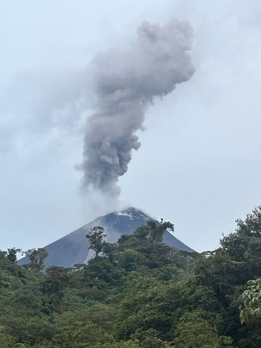
Since yesterday, surveillance cameras and satellite images have detected several gas and ash emissions reaching heights of between 300 and 1,000 meters above the crater, in southwest and west directions. Regarding this activity, the National Aviation Administration for Natural Resources Conservation (VAAC) in Washington issued an activity report regarding a gas and ash emission reaching a height of 750 meters above the crater, in a west direction.
Other monitoring parameters:
Thanks to the FIRMS satellite system, nine thermal alerts were recorded in the volcano area.
In addition, the MIROVA-VIIRS system recorded a moderate thermal anomaly over the past 24 hours.
Observation:
Over the past 24 hours, several episodes of incandescent material falling on the volcano’s flanks were observed, reaching up to 1,000 m below the crater level.
However, the volcano remained cloudy most of the time.
Alert Level – SGR: Orange
Source : IGEPN
Photo : IGEPN , ( 03/2025)
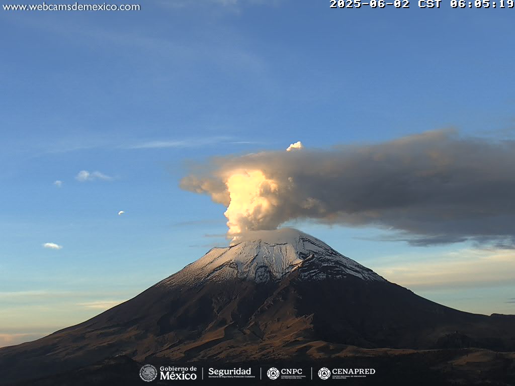
Mexico , Popocatepetl :
June 2, 11:00 a.m. (June 2, 5:00 p.m. GMT), Activity in the last 24 hours
64 low-intensity exhalations accompanied by water vapor, other volcanic gases, and occasional ash were detected.
232 minutes of low-amplitude tremors were also recorded (125 high-frequency and 107 harmonic).
During the morning, constant emissions of water vapor and other volcanic gases were observed. At the time of writing, visibility is reduced due to cloud cover in the crater area; any emissions will be oriented toward the southwest.
The Popocatépetl volcano warning light is at Yellow Phase 2.
The expected scenarios for this phase are as follows:
A few minor to moderate explosions
Occurrence of tremors of varying amplitude
Light to moderate ashfall in surrounding towns and some more distant towns
Expulsion of incandescent fragments within a 12-kilometer exclusion radius
Lahars descending into ravines are expected due to ash accumulation on the slopes and their interaction with the precipitation expected in the coming weeks
Possibility of pyroclastic flows not reaching towns
Source et photo : Cenapred .