May 31 , 2025.
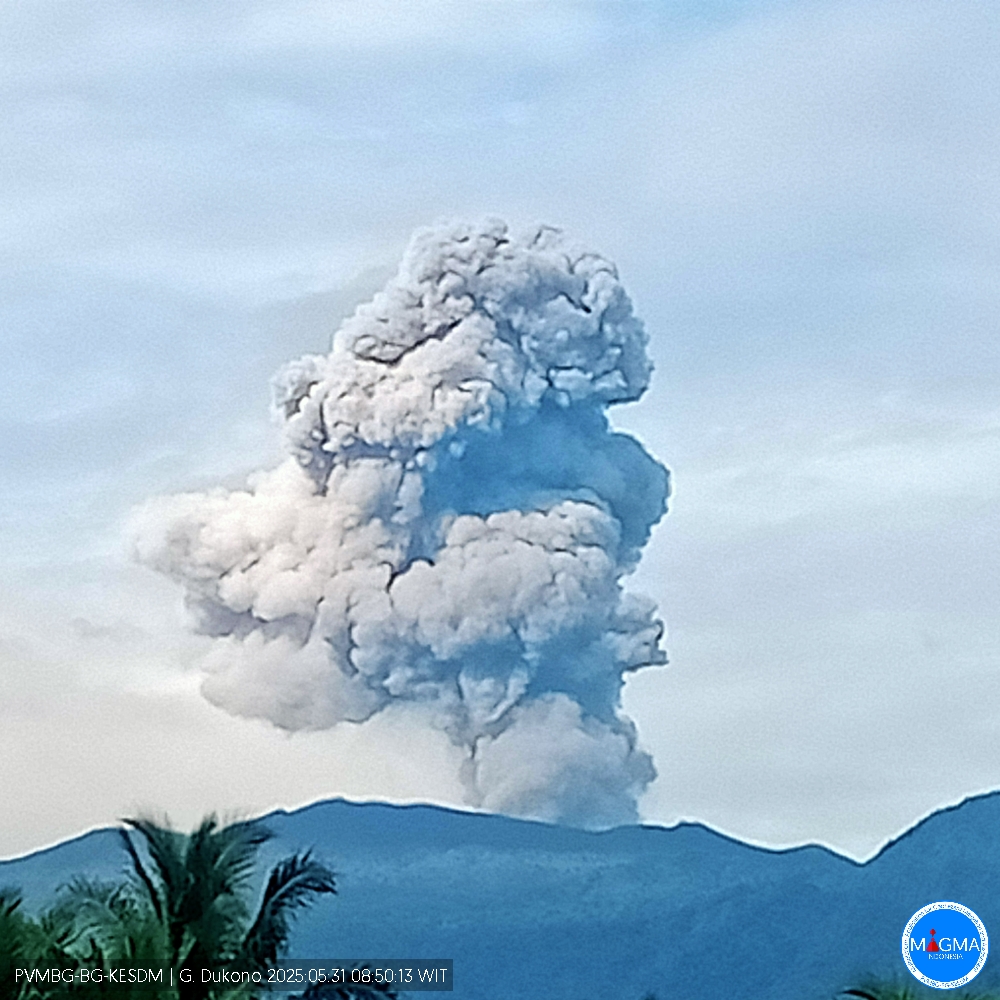
Indonesia , Dukono :
Mount Dukono erupted on Saturday, May 31, 2025, at 8:47 a.m. (local time). The observed ash column was ± 1,800 m above the summit (± 2,887 m above sea level). The ash column was white to gray, with a higher intensity, oriented toward the south. At the time of this report, the eruption was still ongoing.
VOLCANO OBSERVATORY NOTICE FOR AVIATION – VONA
Issued : May 30 , 2025
Volcano : Dukono (268010)
Current Aviation Colour Code : ORANGE
Previous Aviation Colour Code : orange
Source : Dukono Volcano Observatory
Notice Number : 2025DUK118
Volcano Location : N 01 deg 41 min 35 sec E 127 deg 53 min 38 sec
Area : North Maluku, Indonesia
Summit Elevation : 3478 FT (1087 M)
Volcanic Activity Summary :
Eruption with volcanic ash cloud at 23h47 UTC (08h47 local).
Volcanic Cloud Height :
Best estimate of ash-cloud top is around 9238 FT (2887 M) above sea level or 5760 FT (1800 M) above summit. May be higher than what can be observed clearly. Source of height data: ground observer.
Other Volcanic Cloud Information :
Ash cloud moving to south. Volcanic ash is observed to be white to gray. The intensity of volcanic ash is observed to be thick.
Remarks :
Eruption and ash emission is continuing. Eruption recorded on seismogram with maximum amplitude 34 mm. Tremor recorded on seismogram with maximum amplitude 4 mm.
Source et photo : Magma Indonésie .
Costa Rica , Poas :
Latitude: 10.20°N;
Longitude: 84.23°W;
Altitude: 2,687 m.
Current Activity Level: Caution
Following the eruption on May 19, no further events with ash emission or ejection of ballistic blocks have been recorded.
Since May 20, the amplitude of the continuous seismic tremor, with frequencies between 2 and 5 Hz, has remained relatively low compared to recent weeks. On May 29, harmonic tremor was observed with a dominant frequency around 1.3 Hz.
The acoustic tremor has remained almost constant, with some variations, but is generally of low intensity.
The number of long-period (LP) events has remained stable over the past two weeks. On May 28, six proximal volcano-tectonic (pVT) events were recorded on the northwest flank of von Frantzius cone, at a depth of approximately 5 km.
Geodetic monitoring has detected vertical uplift and extension of the crater crust since December 2024, with weekly amplitude variations. Overall, the uplift of the floor north of the crater reached 3 to 4 cm, comparable to that observed during the 2017 eruption. Last week, slight uplift and contraction of the crater were recorded.
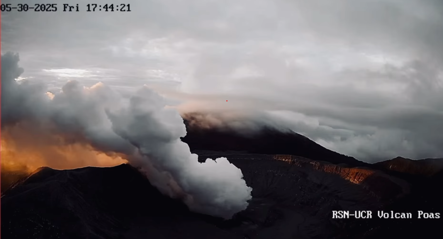
The Poás volcano continues to emit large quantities of magmatic gases, although less than during the degassing peak in late April. The average SO2 flux measured by the DOAS station increased this week (459 ± 46 t/d) compared to the previous week (309 ± 21 t/d). The Boca A gas plume is rich in SO2, as evidenced by its blue color. The mass of SO2 measured in the Costa Rican atmosphere by the TROPOMI sensor on the Sentinel-5P satellite decreased significantly this week (about 89 tons on May 28, half the average compared to the previous week). Webcams continue to detect electromagnetic radiation in the infrared region (heat) and reddish visible light in Bocas A and C. Gas composition measurements are consistent with a surface magmatic source. The MultiGAS station near Boca A measured an average SO2/CO2 ratio of 2.2 ± 0.5, with compositions very similar to those of the previous week. The H2S/SO2 ratio has been very low (< 0.1) for several weeks. The gases are interpreted as originating from a surface magmatic source, with no significant influence from the hydrothermal system.
Source : Ovsicori
Photo : RSN UCR , Capture d’écran 31 Mai 2025 .
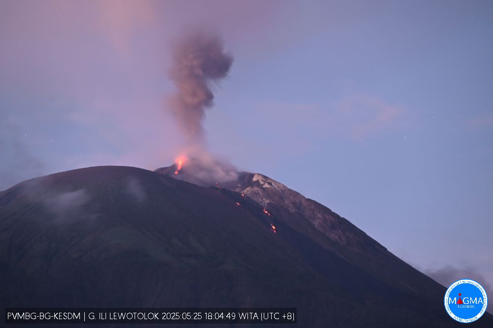
Indonesia , Ili Lewotolok :
INCREASED ERUPTIVE ACTIVITY OF ILI LEWOTOLOK VOLCANO ON MAY 30, 2025.
On May 30, 2025, eruptive activity at Ili Lewotolok Volcano intensified. This is indicated by the observed increase in the height of the eruptive column. According to visual monitoring from the volcano observation post, the eruptive column reached a height of 1,000 meters, forming a white, gray, to black column, accompanied by a rumbling sound.
The activity level of Ili Lewotolok Volcano, located in Lembata Regency, East Nusa Tenggara Province, is currently Level II (WASPADA).
Seismic data for the period May 23-30, 2025, up to 6:00 PM WITA:
817 eruption earthquakes,
3 avalanche earthquakes,
1,480 emission earthquakes,
32 harmonic tremors,
4 non-harmonic tremors,
11 deep volcanic earthquakes,
11 local tectonic earthquakes,
14 distant tectonic earthquakes.
Visually, the volcano is clearly visible until it is covered by fog. Thin to thick white smoke has been observed in the crater. The height of the observed eruptive column varies from 100 to 1,000 meters from the summit. The weather is sunny to rainy, with light to moderate winds from the southeast, southwest, west, and northwest.
Therefore, the community and stakeholders are advised to:
Refuse to enter or carry out any activities within a 2 km radius of the Mount Ili Lewotolok activity center, and to ensure that residents of the villages of Lamatokan and Jontona are constantly aware of the potential risk of lava avalanches and hot clouds originating from the eastern portion of the Mount Ili Lewotolok peak/crater.
Refuse to enter or carry out any activities in the southern and southeastern sectors up to 2.5 km from the Mount Ili Lewotolok activity center, and to be aware of the potential risk of lava avalanches and hot clouds originating from the southern and southeastern portion of the Mount Ili Lewotolok peak/crater. It is prohibited to enter or carry out activities in the Western Sector Zone, within 2.5 km of the Mount Ili Lewotolok activity center, and be aware of the potential risk of lava avalanches and hot clouds from the southern and southeastern parts of the Mount Ili Lewotolok peak/crater.
Use a mask and other equipment to protect your eyes and skin to avoid respiratory problems (ARI) and other health problems caused by volcanic ash.
Source et photo : Magma Indonésie .
Colombia , Nevado del Ruiz :
Manizales, May 27, 2025, 4:50 a.m.
Regarding the monitoring of the activity of the Nevado del Ruiz volcano, the Colombian Geological Survey (SGC), an entity affiliated with the Ministry of Mines and Energy, reports that:
During the week of May 20-26, 2025, the volcano continued to exhibit unstable behavior. Compared to the previous week, the main variations in the monitored parameters were:
– Seismic signals related to fluid dynamics in the volcanic conduits increased, with an increase in the number of recorded earthquakes and a slight increase in the seismic energy released compared to the previous week. The energy levels of the seismic signals ranged from low to moderate. The cameras (conventional or thermographic) used to monitor the volcano confirmed a pulsating ash emission associated with the seismic signals. Similarly, variations in the apparent temperature of the ejected materials linked to this emission of ash were observed.

– Seismic activity associated with rock fracturing processes within the volcanic edifice decreased in terms of the number of recorded earthquakes and the seismic energy released. Most of the seismic events were located up to 7 km from the crater, on the northeast, southeast, southwest, and west flanks of the volcano, at depths between 1 km and 8 km measured from the volcanic summit. In addition, tremors were recorded in the Arenas crater, at depths less than 2 km from the summit. The strongest earthquake of the week was recorded on May 22 at 12:00 with a magnitude of 1.6, located in the crater, at a depth of 1 km from the volcano’s summit. – Water vapor and gas emissions, mainly sulfur dioxide (SO₂), into the atmosphere from the Arenas crater were variable. Estimated SO₂ outgassing flux values increased compared to previous weeks, primarily due to the prevailing wind direction this week, which facilitated data collection. Satellite monitoring, conducted to complement the assessment of this parameter, revealed significant SO₂ releases.
– The vertical height of the gas and water vapor column remained mostly below 1,000 m, with a maximum of 700 m (measured above the volcanic summit). During dispersal, the maximum height reached was 600 m, during the only confirmed ash emission of the week, recorded on May 25 at 3:39 a.m. The direction of dispersal showed a predominant trend toward the northwest flank of the volcano, with occasional variations toward the west-northwest and north-northwest.
– When monitoring thermal anomalies at the floor of Arenas Crater using satellite monitoring platforms, detection was limited due to the atmospheric conditions of high cloud cover in the area; however, some reports of low energy levels were obtained.
Source et photo : SGC
La Martinique , Mount Pelée :
Weekly report, Paris Institute of Earth Physics / Martinique Volcanological and Seismological Observatory
Saint-Pierre, May 30, 2025, at 3:00 p.m. local time (GMT-4)
Volcanic activity decreased this week, with 18 earthquakes of volcanic origin observed.
Between May 23, 2025, at 4:00 p.m. (UT) and May 30, 2025, at 4:00 p.m. (UT), the OVSM recorded:
• 17 low-energy volcano-tectonic earthquakes. These earthquakes were clearly identified as originating from one of the well-known seismically active zones on Mount Pelée,
located between 1.0 and 1.4 km deep below the volcano’s summit. The shallow volcano-tectonic seismicity is associated with microfracturing within the volcanic edifice, linked to the overall reactivation of the volcano observed since late 2018.
• One long-period earthquake with a magnitude of Mlv = 0.8 was located approximately 3 km southwest of Mount Pelée at a depth of 26 km. Deep long-period earthquakes contain only low frequencies and are associated with the circulation of magmatic fluids deep within the Mount Pelée volcanic system.

No earthquakes were felt by the population.
The previous week, the OVSM recorded 59 earthquakes of volcanic origin. As of May 30, 2025, and over the past four weeks, the OVSM has observed a total of 364 volcanic earthquakes, an average of 91 earthquakes per week.
During phases of volcanic reactivation in volcanoes similar to Mount Pelée, seismic activity of varying intensity and frequency is commonly observed.
For more details on observations and interpretations of volcanic activity over the longer term, refer to the OVSM’s monthly bulletins.
The alert level is currently YELLOW: vigilance.
Source : Direction de l’OVSM-IPGP.
Photo : rci.fm