May 29 , 2025.
Alaska , Spurr :
Wednesday, May 28, 2025, 12:17 PM AKDT (Wednesday, May 28, 2025, 20:17 UTC)
61°17’56 » N 152°15’14 » W,
Summit Elevation 11070 ft (3374 m)
Current Volcano Alert Level: ADVISORY
Current Aviation Color Code: YELLOW
Summary
The magma intrusion beneath Mount Spurr has stalled, and the likelihood of an eruption continues to gradually decline.
The volcano remains at an elevated state of unrest, and an explosive eruption like those that occurred in 1953 and 1992 is still possible.
We expect additional increases in seismic activity, gas emissions, surface deformation, and surface heating prior to an eruption, if one were to occur. These changes may provide days to weeks of warning.
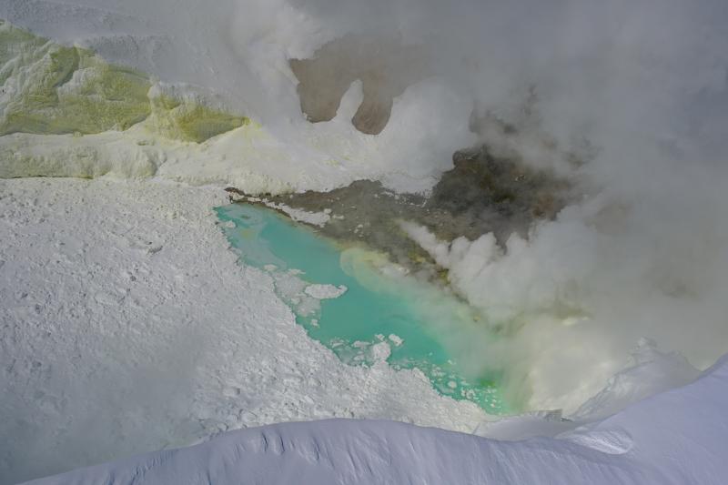
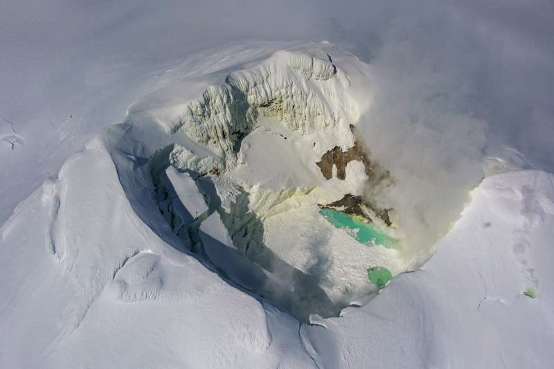
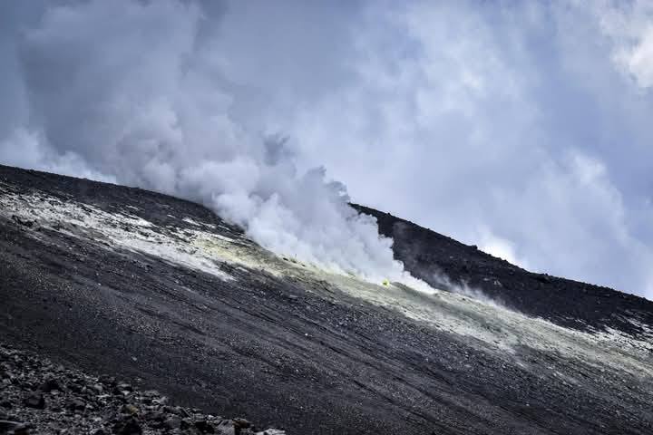
Summit crater of Mount Spurr on May 23, 2025. Gas emissions are visible from steaming fumaroles, primarily on the north shore of the crater lake. The lake continues to have floating ice from ongoing collapse of ice on the inner crater walls, and is a blue-green color. Sulfur staining is visible on the snow inside the crater.
Recent observations
Earthquakes:
Earthquake activity beneath Mount Spurr remains elevated. Following a steady decline from late March through April, shallow earthquake activity has increased in the past 2 weeks to ~March levels of about 100 events per week. The rate of deep earthquakes (greater than 6 miles, or 10 km, below sea level) continues unchanged, suggesting that magma remains active deep beneath the volcano.
Gas: A gas-measurement flight was conducted last week on Friday May 23, which measured gases from both the summit crater of Mount Spurr and the Crater Peak flank vent. Measured emissions were slightly lower, but within the uncertainty bounds of those measured during the last gas flight on April 24. CO2 values from both vents remain above background levels, but similar values were reported with unrest in 2004-2006, when the volcano did not erupt. Likewise, SO2 values at the summit are above background, but similar to 2004-2006 observations. No SO2 was detected from Crater Peak. In addition, satellites have regularly detected low-level SO2 from Mount Spurr in the past several weeks.
Ground deformation:
Ground deformation has paused since mid-March, suggesting the shallow magma intrusion has stalled. Recent data from a single station over the past 2 weeks shows radial outward motion from the volcano, but this trend is the result of seasonal environmental effects unrelated to volcanic activity. This is supported by observations from previous years when vertical deformation is related to seasonal changes and not volcanic activity.
Surface changes:
Snow and ice continue to collapse into the summit crater lake that formed during this period of unrest, and steam emissions within and around the summit crater continue unchanged. There have also been no significant changes to the fumaroles within Crater Peak over the past month.
Interpretations and Hazards
Over the past month, various monitoring data show no definite trends, which increases the overall uncertainty of eruption. Earthquake activity and gas emissions continue to be above background levels, but activity is not currently uniformly increasing, nor is an explosive eruption a certainty.
The pause in deformation suggests that the ascent of magma to shallow levels beneath the volcano over the past 17 months has stalled. This intrusion of magma could still lead to an eruption, but gas and earthquake activity do not clearly indicate an unstable or pressurizing system. As was the case at Mount Spurr during the 2004–2006 unrest, most intrusions do not reach the surface to erupt. However, a similar pause occurred in fall 2024, and it remains possible that magma ascent could resume.
If an eruption were to occur, an explosive eruption like those that occurred in 1953 and 1992 is the most likely outcome. We expect to see additional changes to monitoring data prior to an eruption, as magma moves closer to the surface. This would include a change in the rate and character of earthquakes, onset of sustained seismic tremor, further increased gas emissions, changes in surface deformation, and melting of snow and ice. In 1992, such changes occurred about three weeks prior to the first eruption.
Should earthquake activity or other monitoring data suggest that an eruption is likely within hours or days, AVO would raise the Aviation Color Code and Alert Level for Mount Spurr.
Source : AVO.
Photos : Loewen Matt / AVO : USGS.
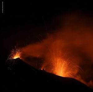
Japan , Sakurajima :
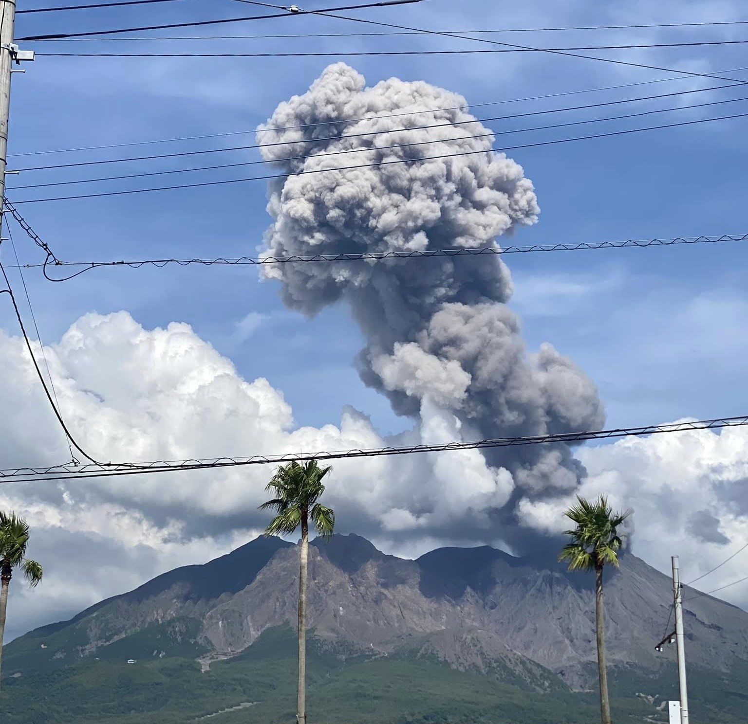
The Japan Meteorological Agency (JMA) reported ongoing eruptive activity at Minamidake Crater (Aira Caldera’s Sakurajima volcano) during 19-28 May. The seismic network recorded 44 eruptive events and 38 explosions during 19-23 May that produced ash plumes rising up to 3 km above the crater rim and drifting N; the tallest plume followed an explosion at 15h00 on 20 May. Large blocks from the explosions were ejected as far as 1.2 km from the crater rim. Sulfur dioxide emissions were extremely high, averaging 11,200 tons per day (t/d) on 20 May and 4,300 t/d on 22 May. Deformation data indicated continuing inflation. Only very small eruptive events were recorded during 26-28 May. The Alert Level remained at 3 (on a 5-level scale), and the public was warned to be cautious within 2 km of both the Minimadake and Showa craters.
The Aira caldera in the northern half of Kagoshima Bay contains the post-caldera Sakurajima volcano, one of Japan’s most active. Eruption of the voluminous Ito pyroclastic flow accompanied formation of the 17 x 23 km caldera about 22,000 years ago. The smaller Wakamiko caldera was formed during the early Holocene in the NE corner of the caldera, along with several post-caldera cones. The construction of Sakurajima began about 13,000 years ago on the southern rim and built an island that was joined to the Osumi Peninsula during the major explosive and effusive eruption of 1914. Activity at the Kitadake summit cone ended about 4,850 years ago, after which eruptions took place at Minamidake. Frequent eruptions since the 8th century have deposited ash on the city of Kagoshima, located across Kagoshima Bay only 8 km from the summit. The largest recorded eruption took place during 1471-76.
Sources: Japan Meteorological Agency (JMA) , GVP.
Photo : Kumiko Nagai
Kamchatka , Klyuchevskoy :
VOLCANO OBSERVATORY NOTICE FOR AVIATION (VONA)
Issued: May 28 , 2025
Volcano: Klyuchevskoy (CAVW #300260)
Current aviation colour code: ORANGE
Previous aviation colour code: yellow
Source: KVERT
Notice Number: 2025-31
Volcano Location: N 56 deg 3 min E 160 deg 38 min
Area: Kamchatka, Russia
Summit Elevation: 4750 m (15580 ft)
Volcanic Activity Summary:
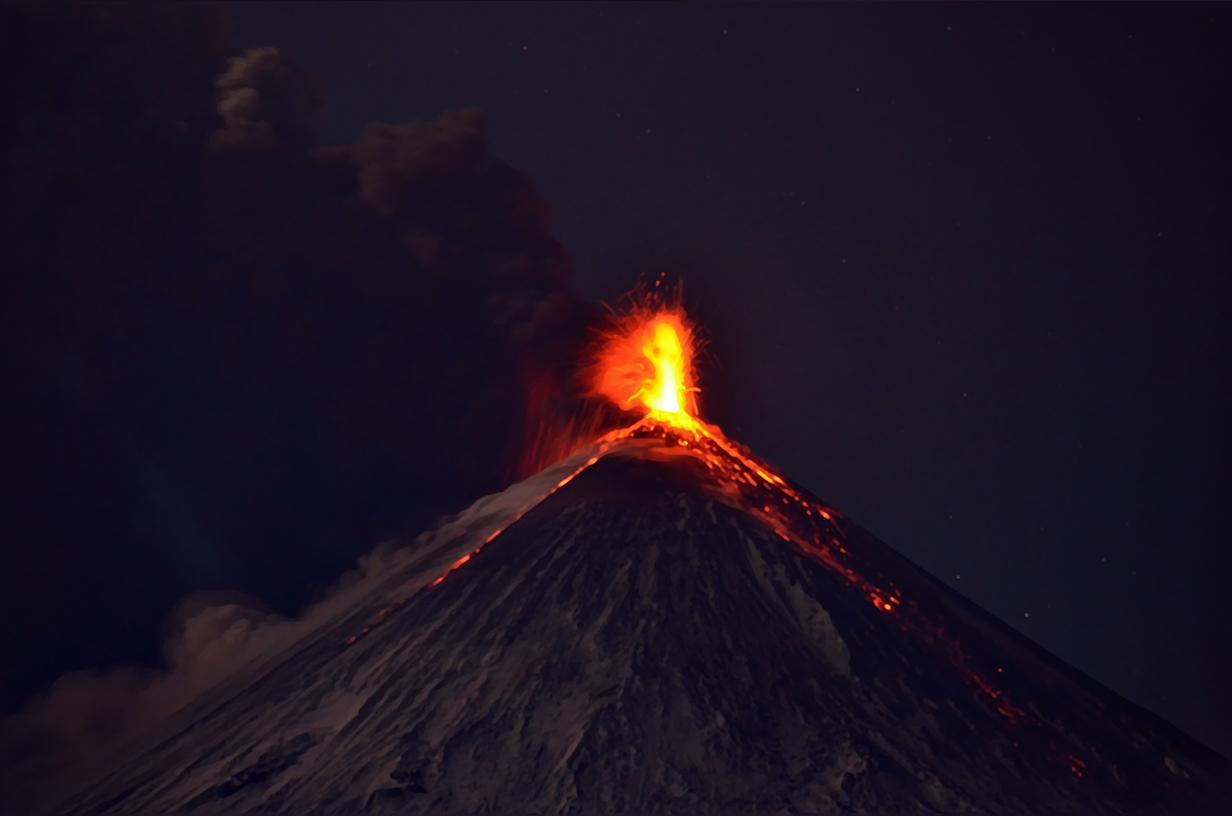
The explosive activity of the volcano continues. Video data by KVERT shows the explosions send ash up to 6.5 km a.s.l., and the ash plume extending for 5 km to the southwest of the volcano.
The summit explosive eruption of the volcano continues. The ash explosions up to 7-8 km (23,000-26,200 ft) a.s.l. could occur at any time. Ongoing activity could affect international and low-flying aircraft.
Volcanic cloud height:
6000-6500 m (19680-21320 ft) AMSL Time and method of ash plume/cloud height determination: 20250528/1945Z – Video data
Other volcanic cloud information:
Distance of ash plume/cloud of the volcano: 5 km (3 mi)
Direction of drift of ash plume/cloud of the volcano: SW
Time and method of ash plume/cloud determination: 20250528/1945Z – Video data
Source : Kvert .
Photo : Andrew Matseevsky ( 2023)
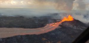
Tonga Archipelago , Home Reef :
The Tonga Geological Services reported that the eruption at Home Reef continued during 11-24 May, though satellite observations suggested decreasing activity. Thermal anomalies were last detected on 4 May and no visible ash emissions were identified in a 15 May image, though discolored water surrounding the island suggested submarine activity. Evidence for explosive activity during 20-21 May included new tephra deposits on the cone’s flanks and low-level ash plumes. Weather clouds often obscured views. Infrasound instruments did not detect any signals. The Aviation Color Code remained at Yellow (the second lowest level on a four-level scale, the Maritime Alert Level remained at Orange (the third level on a four-level scale) with advice to stay at least 2 nautical miles (3.7 km) from the island, and the Alert Level for residents of Vava’u and Ha’apai remained at Green (the first level on a four-level scale).
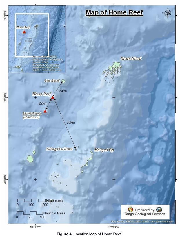
Home Reef, a submarine volcano midway between Metis Shoal and Late Island in the central Tonga islands, was first reported active in the mid-19th century, when an ephemeral island formed. An eruption in 1984 produced a 12-km-high eruption plume, large amounts of floating pumice, and an ephemeral 500 x 1,500 m island, with cliffs 30-50 m high that enclosed a water-filled crater. In 2006 an island-forming eruption produced widespread dacitic pumice rafts that drifted as far as Australia. Another island was built during a September-October 2022 eruption.
Sources: Tonga Geological Services, Government of Tonga , GVP.
Photo : Services géologiques des Tonga, Gouvernement des Tonga.
Colombia , Puracé – Los Coconucos Volcanic Range :
Popayán, May 27, 2025, 2:00 p.m.
Regarding the monitoring of the activity of the Puracé volcano and the Los Coconucos volcanic chain, the Colombian Geological Survey (SGC), an entity attached to the Ministry of Mines and Energy, reports that:
During the week of May 20-26, seismic activity continued to decrease compared to previous weeks, particularly with regard to fluid movements in volcanic conduits.
Earthquakes associated with rock fracturing were located mainly between the Puracé and Piocollo volcanoes, at depths between 1 and 3 km, reaching a maximum magnitude of 0.7. Events related to fluid dynamics were concentrated mainly beneath the crater of the Puracé volcano, at a depth of less than 500 m, and were characterized by low energy input. Moderate levels of sulfur dioxide (SO2) emissions were recorded by satellite and field instruments. In addition, the slow deformation process continued between the Puracé, Piocollo, and Curiquinga volcanoes.
Visible and infrared webcam images continued to show degassing processes in the lateral fumarole and inside the crater of the Puracé volcano, characterized by gas columns reaching 1,400 meters above the summit of the volcanic chain.
In conclusion, continuous degassing from the lateral fumarole and crater of the Puracé volcano continued throughout the week, accompanied by moderate SO2 emissions, localized seismic activity beneath the Puracé and Piocollo volcanoes, and slow ground deformation, indicating the persistence of an active volcanic system. In a yellow alert state, phenomena such as sporadic ash emissions (minor eruptions of limited magnitude and effects, whose dispersion depends on wind direction), the presence of incandescent light, small explosions in the crater, low-energy thermal anomalies, noise, felt earthquakes, odors, precipitation of elemental sulfur near the crater, in hot springs and fumaroles, as well as degassing outside the crater, may occur. Fissure formation and minor lahars, among other things, may also occur.
In view of the above, the SGC recommends closely monitoring the evolution of volcanic activity through weekly bulletins and other information published on official channels, as well as following the instructions of local and departmental authorities and the National Disaster Risk Management Unit (UNGRD).
The alert status for volcanic activity remains at yellow alert: an active volcano exhibiting changes in the baseline behavior of monitored parameters and other manifestations.
Source : SGC.
Photo : Carlos Carillo .