May 08 , 2025.
Hawaii , Kilauea :
Tuesday, May 6, 2025, 10:30 PM HST (Wednesday, May 7, 2025, 08:30 UTC)
19°25’16 » N 155°17’13 » W,
Summit Elevation 4091 ft (1247 m)
Current Volcano Alert Level: WATCH
Current Aviation Color Code: ORANGE
Activity Summary:
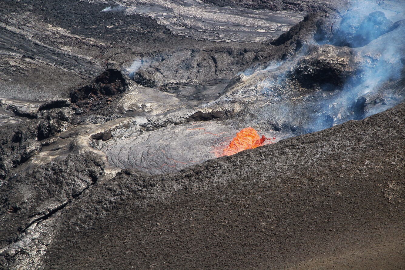
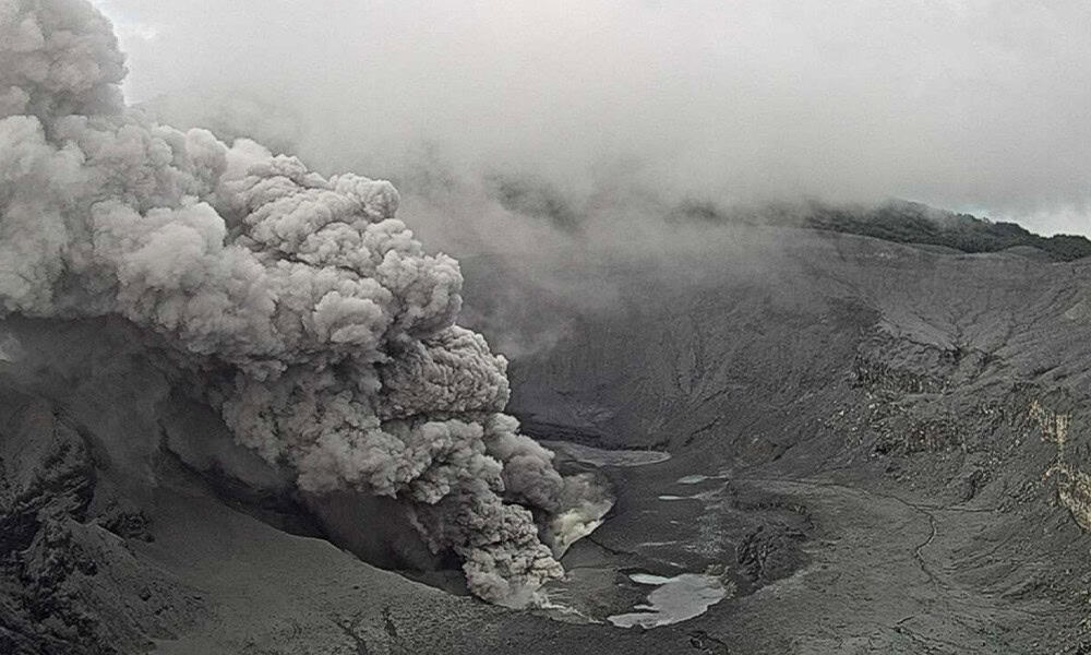
Episode 20 ended at 9:58 p.m. HST on Tuesday, May 6, 2025, after 4.5 hours of sustained fountaining. The Halema’uma’u eruption is currently paused.
The sustained fountaining phase of episode 20 began at 5:28 p.m. on Tuesday, May 6, 2025. Lava fountains and flows erupted from both vents, but the north vent was much more active than the south vent during all phases of episode 20. Fountains from the north vent quickly reached estimated heights of more than 500 feet (150 meters). Fountains from the south vent reached heights of up to about 65 feet (20 meters). It is currently estimated that lava flows from this episode covered less than half of the Halema’um’au crater floor. The sustained fountaining phase was preceded by almost 31 hours of precursory low-level activity that included gas-pistoning events in the north vent that produced low lava dome fountains, overflows, and drainbacks, as well as sluggish lava flows from the south vent.
On May 5, 2025, USGS Hawaiian Volcano Observatory scientists visiting the western rim of Halemaʻumaʻu crater watched several cycles of lava filling and draining within the north vent of Kīlauea’s ongoing summit eruption. Dome fountains in the vent’s lava pond reached approximately 6 meters (20 feet) in height. Similar behavior has been observed prior to several recent episodes of higher and more vigorous lava fountaining during the course of the eruption, which began December 23, 2024.
The end of episode 20 fountaining activity was accompanied by a rapid change in summit tilt from deflation to inflation, along with a rapid decrease in tremor. The Uēkahuna tiltmeter (UWD) recorded approximately 6 microradians of deflationary tilt between the start and end of episode 20 fountaining.
Kīlauea’s current eruption in Halemaʻumaʻu crater within Kaluapele (the summit caldera) began on December 23, 2024. There have now been 20 episodes separated by pauses in activity. All eruptive activity remains within Hawaiʻi Volcanoes National Park. No significant activity has been noted along Kīlauea’s East Rift Zone or Southwest Rift Zone. Current hazards include volcanic gas emissions and windblown volcanic glass (Pele’s hair) and tephra that have impacted Hawaiʻi Volcanoes National Park and nearby communities.
Each episode of Halemaʻumaʻu lava fountaining since December 23, 2024, has continued for 13 hours to 8 days and episodes have been separated by pauses in eruptive activity lasting less than 24 hours to 12 days.
No changes have been detected in the East Rift Zone or Southwest Rift Zone. HVO continues to closely monitor Kīlauea and will issue an eruption update tomorrow morning unless there are significant changes before then.
Kīlauea Volcano Alert Level/Aviation Color Code remain at WATCH/ORANGE. All current and recent activity is within Hawaiʻi Volcanoes National Park.
Source : HVO
Photo : USGS / M. Zoeller.
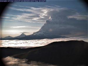
Tonga Archipelago , Home Reef :
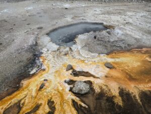
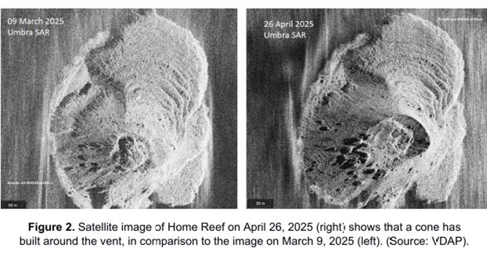
The Tonga Geological Services reported continuing activity at Home Reef with lava effusion and explosive activity at the main vent. A cone had grown around the vent and was 50-100 m high, based on a 26 April satellite image, and the vent had enlarged to about 175 m by 135 m in dimension. New deposits of material were visible on the W and SW flanks, nearly covering the lava lobes emplaced in November and December 2024. A volcanic ash plume was identified in a satellite image at 1354 on 29 April. In a 1 May image steam plumes rose from the vent and water around the island was discolored. Moderate thermal anomalies continued to be detected by the Middle InfraRed Observation of Volcanic Activity (MIROVA) system at least through 3 May. The island was about 540 m N-S and 440 m W-E.
According to the Wellington VAAC intermittent, low-level ash plumes were visible in satellite images and sometimes observed by pilots during 29-30 April and on 3 May rising 0.9-1.2 km (3,000-4,000 ft) a.s.l. and drifting N, NW, W, and SW. The Aviation Color Code remained at Orange (the second highest level on a four-level scale), the Maritime Alert Level remained at Orange (the third level on a four-level scale), and mariners were advised to stay at least 2 nautical miles (3.7 km) away from the island. The Alert Level for residents of Vava’u and Ha’apai remained at Green (the first level on a four-level scale).
Sources: Tonga Geological Services, Government of Tonga, Wellington Volcanic Ash Advisory Center (VAAC) , GVP.
Photo : VDAP
Indonesia , Iya :
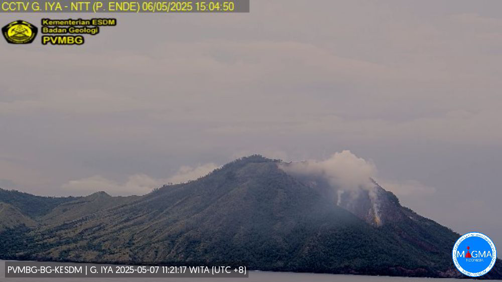
Increased volcanic seismicity at Iya Volcano on May 7, 2025
Iya Volcano (637 m above sea level) is located in Ende Regency, East Nusa Tenggara Province. This mountain is a type of stratovolcano and has been recorded to have erupted since 1671 until the last eruption in 1969. Monitoring of Mount Iya’s activity is carried out visually and instrumentally from the observation post in Paupanda Village. These volcanic eruptions are generally magmatic in nature, accompanied by volcanic ash, ejection of hot rock, and lava flows. Fissures developing around the active crater indicate the risk of a major landslide into the sea in the event of a major eruption.
The activity of Mount Iya during the period from May 1 to 6, 2025, showed white smoke from the crater of low to moderate intensity, reaching 50 to 300 meters above the summit. The weather varies from sunny to rainy, and the wind direction tends to change. Seismic activity has shown an increase since mid-April 2025, particularly in early May. On May 5 and 6, 2025, an earthquake with a magnitude of 2.16 was felt, accompanied by a significant increase in the number of deep volcanic earthquakes, indicating that the magma intrusion process is still ongoing.
Until May 7, 2025, Mount Iya’s activity level is set at Level II (WASPADA). The public is urged to be vigilant in the event of a large-magnitude tectonic earthquake occurring near the mountain, as it could affect volcanic activity. Intensive monitoring continues to anticipate future developments.
Based on the results of visual and instrumental monitoring, Mount Iya’s activity level is Level II (WASPADA) until May 7, 2025.
Source et photo: PVMBG
Costa Rica , Poas :
The Observatorio Vulcanológico y Sismológico de Costa Rica-Universidad Nacional (OVSICORI-UNA) reported continuous gas-and-steam emissions, ash-and-gas emissions sometimes lasting hours, and explosions at Poás during 30 April-6 May. Inflation continued to be detected. Seismic and infrasound sensors recorded seismic-acoustic signals indicating fluctuating eruptive activity with frequent more intense eruptive pulses. The webcams recorded the emissions and incandescence at the vents.
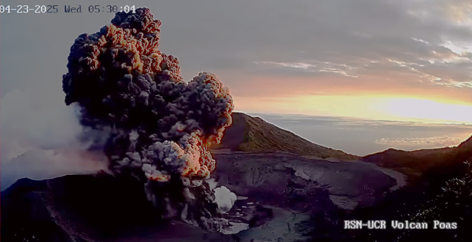
During 29-30 April ash-and-gas plumes rose a few hundred meters above the crater rim and drifted SW, causing significant ashfall in the Sarchi area (18 km SW). The density of the ash content was higher in the morning and early afternoon on 30 April. Around 03h00 on 1 May a team conducted a drone overflight and measured a temperature of 180 degrees Celsius, indicating no lava near the surface. A more intense eruptive pulse at 03h15 sent ash-and-gas 500 m above the crater rim. Burning molten sulfur at the vents was visible at night during 1-2 May and continued to be visible during dark hours the rest of the week.
Beginning at 05h00 on 2 May ash emissions were continuous for at least three hours, producing a black-and-white plume that rose less than 1 km above the crater rim and drifted W. Several eruptive pulses with white-and-gray plumes were recorded during the day, notably at 15h20, and drifted W. Ashfall was reported in Grecia and Naranjo, and residents observed rising ash-laden water levels in the Desague (W) and Anonos (N) rivers. Incandescent material was ejected mainly to the W and deposited on the crater floor. Sulfur dioxide emissions averaged 612 tons per day (t/d). Ashfall was reported in San Juan de Grecia (17 km SW), Montes de Oca (37 km SE), and San José (34 km SE), and a sulfur odor was detected in Alajuela (San Ramón, 29 km WSW).
Overnight during 2-3 May incandescence from sulfur combustion suggested temperatures around 160 degrees Celsius. Eruptive pulses at 03h00 and 08h12 on 3 May generated ash-and-gas plumes that rose 500 m above the crater rim and drifted W. Sulfur dioxide emissions detected in satellite data were 508 t/d. Eruptive activity decreased during 3-4 May, characterized by vigorous white gas-and-steam plumes with less ash content. Sulfur combustion produced intense incandescence overnight. The ash content in the emissions increased at around 11h00 and caused a darker plume that drifted W. An ash-and-gas plume from an eruptive pulse at 20h30 rose 600 m above the crater rim and drifted W.
At 20h59 incandescent ballistics were ejected from Boca A and deposited onto the crater floor. Sulfur dioxide emissions measured by a Differential Optical Absorption Spectroscopy (DOAS) station on 5 May averaged 3,190 t/d (+/- 560 t/d), slightly lower than the same measurement made in April but higher compared to historical data. Steam-and-gas emissions continued on 6 May, though they were semi-continuous, less robust, and contained low or no ash content; plumes drifted SW. The volcano’s Alert Level remained at 3 (the second highest level on a four-level scale) and the Aviation Color Code remained at Orange (the second highest color on a four-color scale).
Sources : Observatorio Vulcanologico y Sismologico de Costa Rica-Universidad Nacional (OVSICORI-UNA), GVP.
Photos : RSN-UCR , Ovsicori
Northeast Pacific Ridge (EPR) :
In a 2 May press release the Woods Hole Oceanographic Institution reported that scientists from multiple institutions and universities took part in an expedition to the Northern East Pacific Rise (EPR) at 9.8°N, an area about 1,300 miles west of Costa Rica, and observed a seafloor eruption. On 28 April a team of scientists aboard the Alvin submersible observed a vibrant ecosystem at the Tica hydrothermal vents, ~2,500 m below the surface, including tubeworms, mussels, crabs, fish, and many other animals. During another dive the next day they noted particulate matter in the water column and slightly elevated temperatures. They turned on the lights and saw that Tica was barren, with dead stands of tubeworms covered in fresh basalt and flashes of incandescence indicating ongoing eruptive activity. The dive was aborted, and planned future dives during the length of the expedition were cancelled due to the safety concerns surrounding the eruption. Scientists continued to gather data at Tica by lowering instrumentation into the water until the end of the expedition on 3 May. Precursory activity including rising temperatures and changes in water chemistry at the vents recorded by previously installed instrumentation.
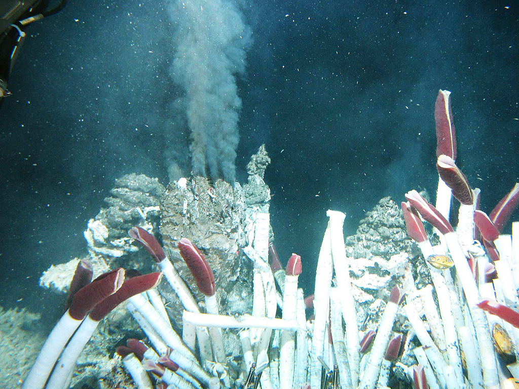
Fluid containing precipitates rises from a « black smoker » chimney at the Tica vent at 9°N on the East Pacific Rise, photographed during a 2004 expedition sponsored by the National Science Foundation. Hot-vent animal communities (such as seen in the foreground of this image from the November to December 1989 expedition) were observed to have been buried by lava flows in 1991. Another eruption in 2005-2006 produced lava flows that covered seismometers.
A series of dives with the submersible Alvin in 1991 on the East Pacific Rise at about 9°50’N detected evidence for a very recent, possibly ongoing, eruption. Hot-vent animal communities documented during November-December 1989 had been buried by fresh basaltic lava flows, and the scorched soft tissues of partially buried biota had not yet attracted bottom scavengers. Fresh black smoker chimneys and new lava flows were present. This site is south of the Clipperton Fracture Zone at a depth of about 2,500 m, and about 1,000 km SW of Acapulco, México; the south end of the Lamont Seamount chain is about 10 km NW. This is also the location where lava flows previously estimated as being less than roughly 50 years old had been found. Later dating using very short half-life radionuclides from dredged samples confirmed the young age of the eruption and indicated that another eruptive event had taken place in late 1991 and early 1992. An eruption in 2005-2006 produced lava flows that entrapped previously emplaced seismometers.
Sources : Woods Hole Oceanographic Institution , GVP.
Photo : GVP , courtesy of Ridge2000, 2004 (www.ridge2000.org/eo/expeditions.php).