September 06 , 2022 .
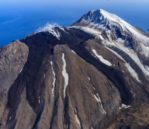
Peru , Ticsani :
Analysis period: from August 14 to 31, 2022, Arequipa, September 01, 2022.
Alert level: GREEN
The Geophysical Institute of Peru (IGP) reports that the geophysical instruments allowing to know the dynamic behavior of the Ticsani volcano (Moquegua Region) have shown in recent hours the occurrence of an abnormal seismic activity currently showing a slight increase. Consequently, it is suggested to the authorities and the population to pay attention to the bulletins issued by the IGP.
During the period considered, it was possible to identify the occurrence of more than 358 volcano-tectonic earthquakes of magnitudes less than M3.5. This seismicity is associated with a rock fracturing process located within a radius of 2.5 km around the Ticsani volcano, at a depth of 10 km from the surface. It is also reported that for the moment, no seismicity associated with a rise in magma has been recorded.
The use of the interferometry technique (INSAR) in the analysis of radar images acquired between August 3 and 21, 2022 made it possible to obtain interferograms highlighting localized deformation anomalies around the dome of the Ticsani volcano, probably associated with active fault activity. The surveillance cameras installed on the Ticsani volcano observed slight gas emissions. No other abnormal surface activity was observed (landslides, etc.)
Satellite observations, through information from the SENTINEL (deformation) TROPOMI (SO2 gas) and MIROVA (superficial hot spots) systems did not identify any anomalies during this period.
Interpretation
The recent seismic activity observed on the Ticsani volcano could give rise to 2 scenarios:
1 / (most likely): that this activity observed on the Ticsani volcano presents a downward trend and finally ceases during the next days or week.
2/ that these events continue for the next few days or weeks, giving way to earthquakes associated with volcanic fluid activity and the probable development of an eruptive process.
Source : Cenvul
Photo : IGP.
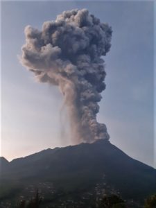
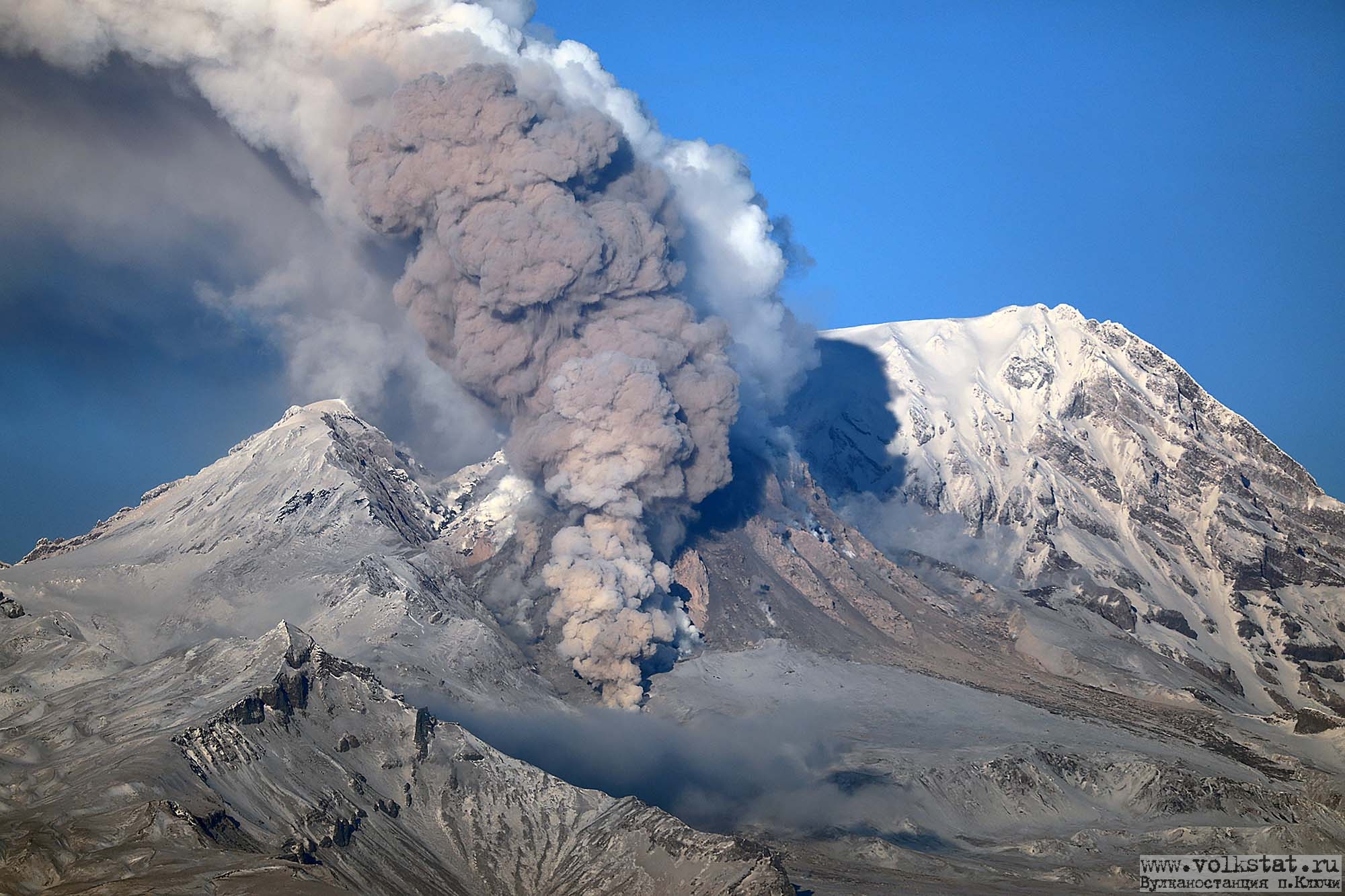
Kamchatka , Sheveluch :
VOLCANO OBSERVATORY NOTICE FOR AVIATION (VONA)
Issued: September 06 , 2022
Volcano: Sheveluch (CAVW #300270)
Current aviation colour code: ORANGE
Previous aviation colour code: orange
Source: KVERT
Notice Number: 2022-105
Volcano Location: N 56 deg 38 min E 161 deg 18 min
Area: Kamchatka, Russia
Summit Elevation: 3283 m (10768.24 ft), the dome elevation ~2500 m (8200 ft)
Volcanic Activity Summary:
A growth of the lava dome continues, a strong fumarole activity, and an incandescence of the lava dome, explosions, and hot avalanches accompanies this process. Video data by KVERT show: explosions sent ash up to 5 km a.s.l., and ash plume is extending to the east-southeast of the volcano.
The extrusive eruption of the volcano continues. Ash explosions up to 10-15 km (32,800-49,200 ft) a.s.l. could occur at any time. Ongoing activity could affect international and low-flying aircraft.
Volcanic cloud height:
4500-5000 m (14760-16400 ft) AMSL Time and method of ash plume/cloud height determination: 20220906/0417Z – Video data
Other volcanic cloud information:
Distance of ash plume/cloud of the volcano: 10 km (6 mi)
Direction of drift of ash plume/cloud of the volcano: ESE
Time and method of ash plume/cloud determination: 20220906/0417Z – Video data
Source : Kvert.
Photo : volkstat ru
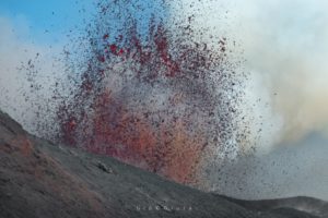
Hawaii , Kilauea :
19°25’16 » N 155°17’13 » W,
Summit Elevation 4091 ft (1247 m)
Current Volcano Alert Level: WATCH
Current Aviation Color Code: ORANGE
Activity Summary:
The summit eruption of Kīlauea Volcano, within Halemaʻumaʻu crater, continued over the past 24 hours. All recent eruptive activity has been confined to the crater. No significant changes have been observed at the summit or in either rift zone.
Halemaʻumaʻu Lava Lake Observations:
Eruption of lava from the western vent into the active lava lake and onto the crater floor continued over the past 24 hours. The active part of the lava lake showed continuous surface activity. The surface outbreak along the northwestern crater floor margin that began around 7:00 pm on Septermber 3, 2022, has not shown surface activity since early evening yesterday.
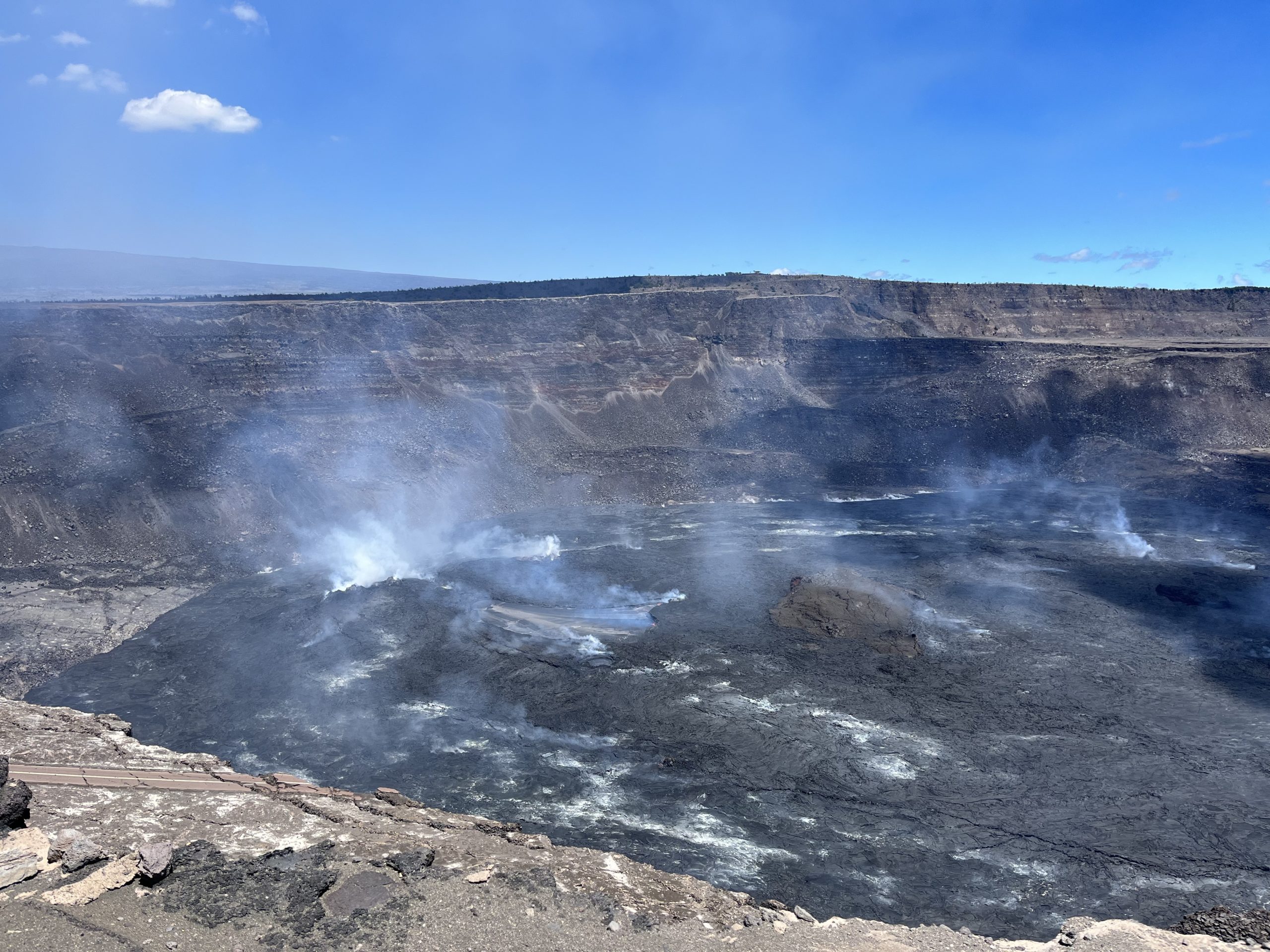
A view of the eruption in Halema‘uma‘u at the summit of Kīlauea, taken on September 2, 2022, by HVO geologists on the south rim of the crater. Nice weather allowed for clear views of the active lava lake, which is in approximately the center of the image. The Uēkahuna Bluff is visible in the background on the opposite rim of the crater, and portions of Crater Rim Drive, which collapsed into the crater in 2018, are visible in the lower left portion of the image.
Summit Observations:
Summit tiltmeters recorded relatively little ground deformation over the past 24 hours. Volcanic tremor remains above background levels. A sulfur dioxide (SO2) emission rate of approximately 1,400 tonnes per day (t/d) was measured on August 26, 2022.
Rift Zone Observations:
No unusual activity has been noted along the East Rift Zone or Southwest Rift Zone; low rates of ground deformation and seismicity continue along both. Measurements from continuous gas monitoring stations downwind of Puʻuʻōʻō in the middle East Rift Zone remain below detection limits for SO2, indicating that SO2 emissions from Puʻuʻōʻō are negligible.
Source : HVO
Photo : USGS / K. Mulliken
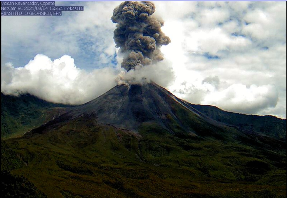
Ecuador , Reventador :
DAILY REPORT OF THE STATE OF THE REVENTADOR VOLCANO, Monday September 5, 2022.
Information Geophysical Institute – EPN.
Surface Activity Level: Moderate, Surface Trend: No change.
Internal activity level: Moderate, Internal trend: No change.
Seismicity: From September 4, 2022, 11:00 a.m. to September 5, 2022, 11:00 a.m.:
Explosion (EXP): 41
Long periods (LP): 32
Emission Tremors (TREMI): 8.
Rains / Lahars:
Light rain was recorded in the area.
Emission / ash column:
Gas and ash emissions were observed up to 800 meters above the level of the crater in a northwest and west direction. The Washington VAAC reported 4 satellite-observed emission alerts, with a westerly and northwesterly direction and heights up to 988 meters above the summit.
Other Monitoring Parameters:
No thermal anomalies have been reported in the last 24 hours.
Observation:
The volcano area was partially cleared during yesterday afternoon and night, recording the emissions described above. At night, an incandescence was observed in the crater as well as the rolling of blocks on all its sides
Alert level: Orange.
Source : IGEPN
Photo : IGEPN (Archives).
Guatemala , Fuego :
Information Bulletin No. 310-2022
According to the special volcanological bulletins issued by the National Institute of Seismology, Volcanology, Meteorology and Hydrology -INSIVUMEH-, the Fuego volcano presented descents of lahars on the main ravines of the volcano, whose vigilance is maintained by the CONRED system.
Bulletins BEFGO #077-2022 and BEFGO #078-2022 detail that the descent of the lahars is done on the Las Lajas and El Jute ravines, tributaries of the Guacalate and Achiguate rivers, as well as in the Ceniza ravine, which is also a tributary of the Aciguate River.
The characteristics of the lahars are weak to moderate, but with a probability of increase due to the rains recorded in the area surrounding the volcanic complex.
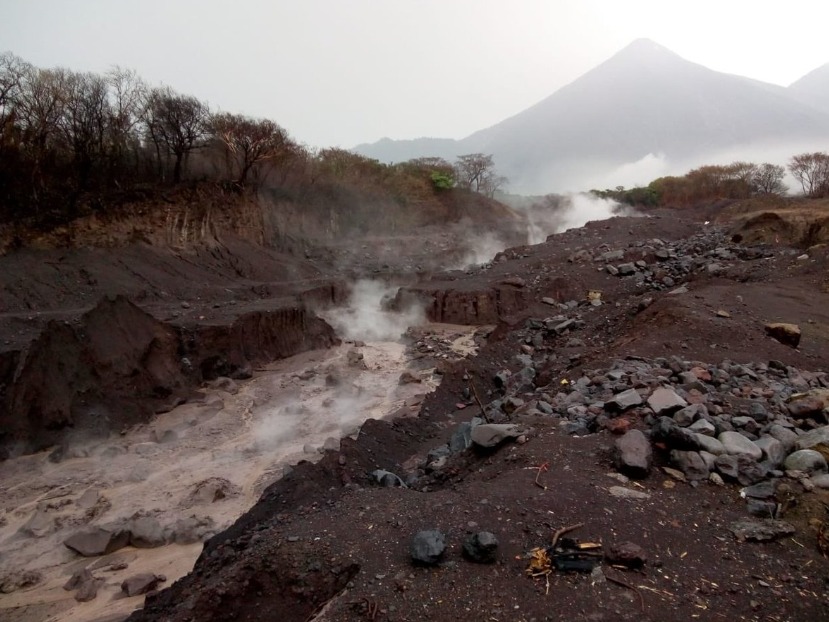
The Volcano Prevention Unit -UPV-, of the Executive Secretariat of the National Coordinator for Disaster Prevention -SE-CONRED- maintains constant vigilance on the ravines and the main flanks of the volcano, reporting on their behavior and coordinating preventive actions with local authorities.
During the rainy season, the descent of lahars on the Fuego and Santiaguito volcanoes is recorded, it is important that the population follow the recommendations of the local authorities and in the event of a situation of risk, emergency or disaster, to call the 119.
In the same way, we call on the population to know the Intervention Plan of their locality to know the evacuation routes and, if necessary, to put into practice the principle of self-evacuation.
Source et photo : Conred.