April 29 , 2025.
Philippines , Bulusan :
BULUSAN VOLCANO ERUPTION UPDATE , 28 April 2025 , 08:30 PM
Summary of Observations:
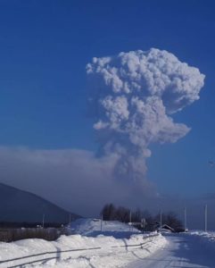
A phreatic eruption occurred at the summit of Bulusan Volcano at 04:36 AM today, 28 April 2025, that lasted 24 minutes based on seismic and infrasound records. The event was detected by all 11 functional stations of the Bulusan Volcano Network (BVN). The eruption generated a voluminous bent plume that rose to 4,500 meters above the crater before drifting to the general west. Thin (trace amounts to 1 millimeter thick) ashfall were subsequently reported in several localities in the west of the Sorsogon Peninsula.
An ash cloud from poorly visible small-volume pyroclastic density currents or PDCs, hazardous mixtures of hot volcanic gas, ash and fragmented rock, was also observed on the southwestern slopes. Rumbling sounds were reported in Brgys. Cogon, Bacolod and Patag, Irosin and Brgys. Añog and Rangas, Juban, while sulfurous fumes were experienced in Brgy. Cogon.
Prior to the eruption, a total of fifty-three (53) volcanic earthquakes were recorded over the 24-hour period of 27 April 2025. Review of data indicated that a strong precursory tremor and infrasound signal was recorded at 3:54 AM, lasting 29 minutes and coinciding towards its end with audible rumbling sounds that were reported by local government officials approximately 15 minutes before the eruption. This tremor event likely signified shallow hydrothermal activity that led to vent opening and eventual eruption at the Bulusan summit. Active degassing from the summit crater has since been transpiring continuously, indicating that hydrothermal unrest has not yet ceased. As of 8:00 PM and with the exception of the eruption signal, a total of eighty-six (86) volcanic earthquakes for today have been recorded by the BVN.
Recommended Actions:
Alert Level 1 (low-level unrest) has been raised over Bulusan Volcano. This means that the volcano is in a state of low-level unrest with increased chances of phreatic eruptions occurring after today’s eruption. Local government units and the public are reminded that entry into the 4-kilometer radius Permanent Danger Zone (PDZ) must be strictly prohibited and that vigilance in the 2-kilometer Extended Danger Zone (EDZ) on the southeast sector must be exercised due to the possible impacts of volcanic hazards such as PDCs, ballistic projectiles, rockfall, avalanches, ashfall and others on these danger areas. Communities that experience ashfall must take all necessary precautions and use protective masks or wet cloth to prevent ash inhalation, with special attention given to vulnerable persons including the elderly, persons with respiratory or cardio-vascular diseases, expecting mothers and infants. Civil aviation authorities must also advise pilots to avoid flying close to the volcano’s summit as ash from any sudden phreatic eruption can be hazardous to aircraft. Furthermore, people living within valleys and along river/stream channels especially on the southeast, southwest and northwest sector of the edifice should be vigilant against sediment-laden stream flows and lahars in the event of heavy and prolonged rainfall should phreatic eruption occur.
DOST-PHIVOLCS is closely monitoring Bulusan Volcano’s condition and any new development will be relayed to all concerned.
Source : DOST-PHIVOLCS
Photo : Konsehal Irvin Fortes
Hawaii , Kilauea :
Monday, April 28, 2025, 9:15 AM HST (Monday, April 28, 2025, 19:15 UTC)
19°25’16 » N 155°17’13 » W,
Summit Elevation 4091 ft (1247 m)
Current Volcano Alert Level: WATCH
Current Aviation Color Code: ORANGE
Activity Summary:
Episode 18 of the ongoing Halemaʻumaʻu eruption ended on April 22. Another episode is likely in approximately 1-5 days.
Kīlauea’s current eruption in Halemaʻumaʻu crater within Kaluapele (the summit caldera) began on December 23, 2024. There have now been 18 episodes separated by pauses in activity. All eruptive activity remains within Hawaiʻi Volcanoes National Park. No significant activity has been noted along Kīlauea’s East Rift Zone or Southwest Rift Zone. Current hazards include volcanic gas emissions and windblown volcanic glass (Pele’s hair) and tephra that have impacted Hawaiʻi Volcanoes National Park and nearby communities.
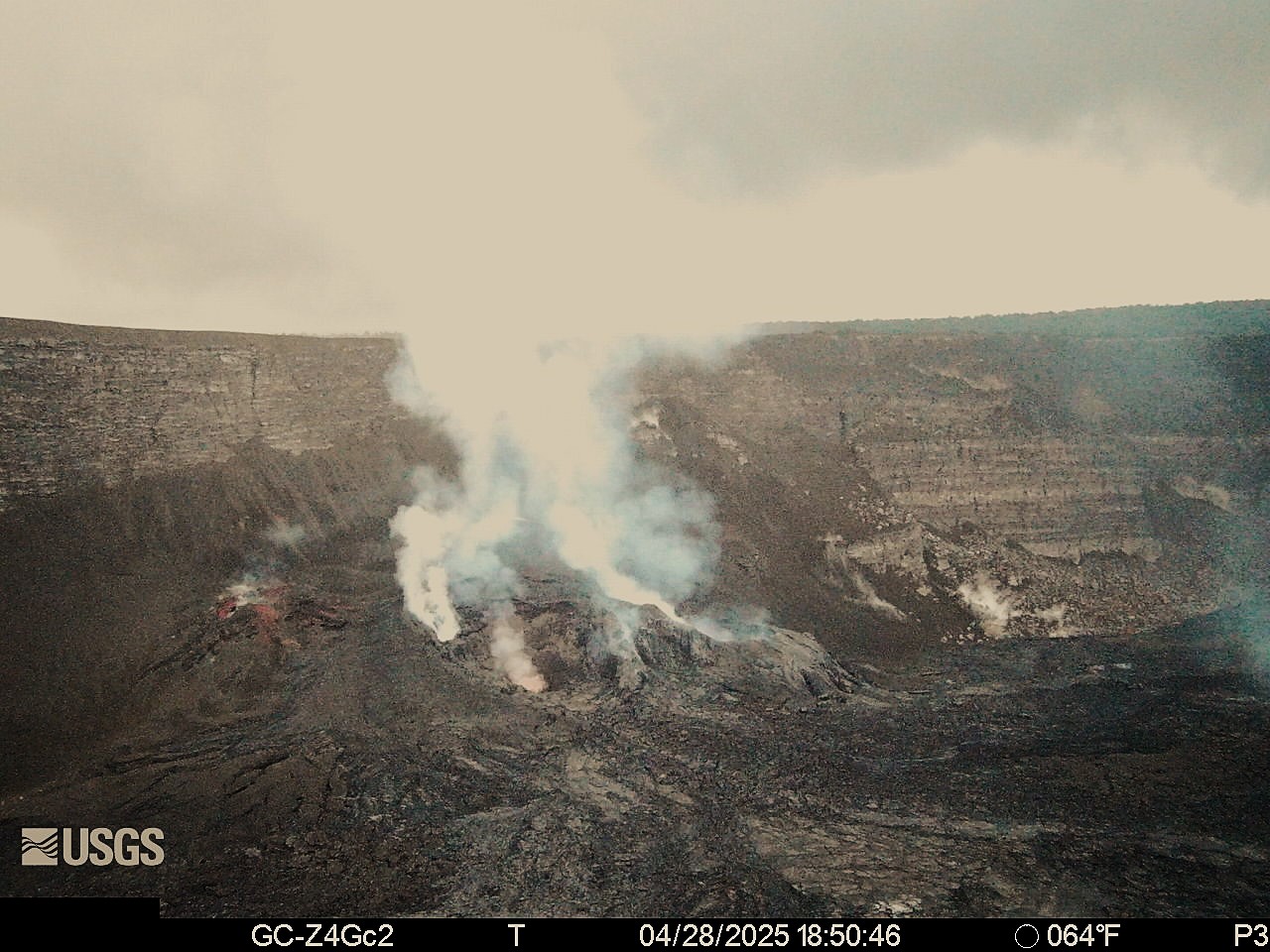
Summit Observations:
Weak spatter was observed from the north vent just before 6:50 pm HST yesterday evening. Glow continued to be observed from both the north and south vents on the S2 camera throughout the evening. The UWD tiltmeter has recorded just under 10 microradians of inflation since the end of episode 18. The last sulfur dioxide (SO2) emission rate measured on April 10 was approximately 1,200 tonnes per day. Strands of volcanic glass known as Pele’s hair from previous episodes are still present throughout the summit area of Hawaiʻi Volcanoes National Park and surrounding communities, and can be remobilized by wind.
Rift Zone Observations:
Rates of seismicity and ground deformation remain very low in the East Rift Zone and Southwest Rift Zone with no significant earthquake activity in the past 24 hours. Sulfur dioxide (SO2) emissions from the East Rift Zone remain below detection limit.
Source et photo : HVO
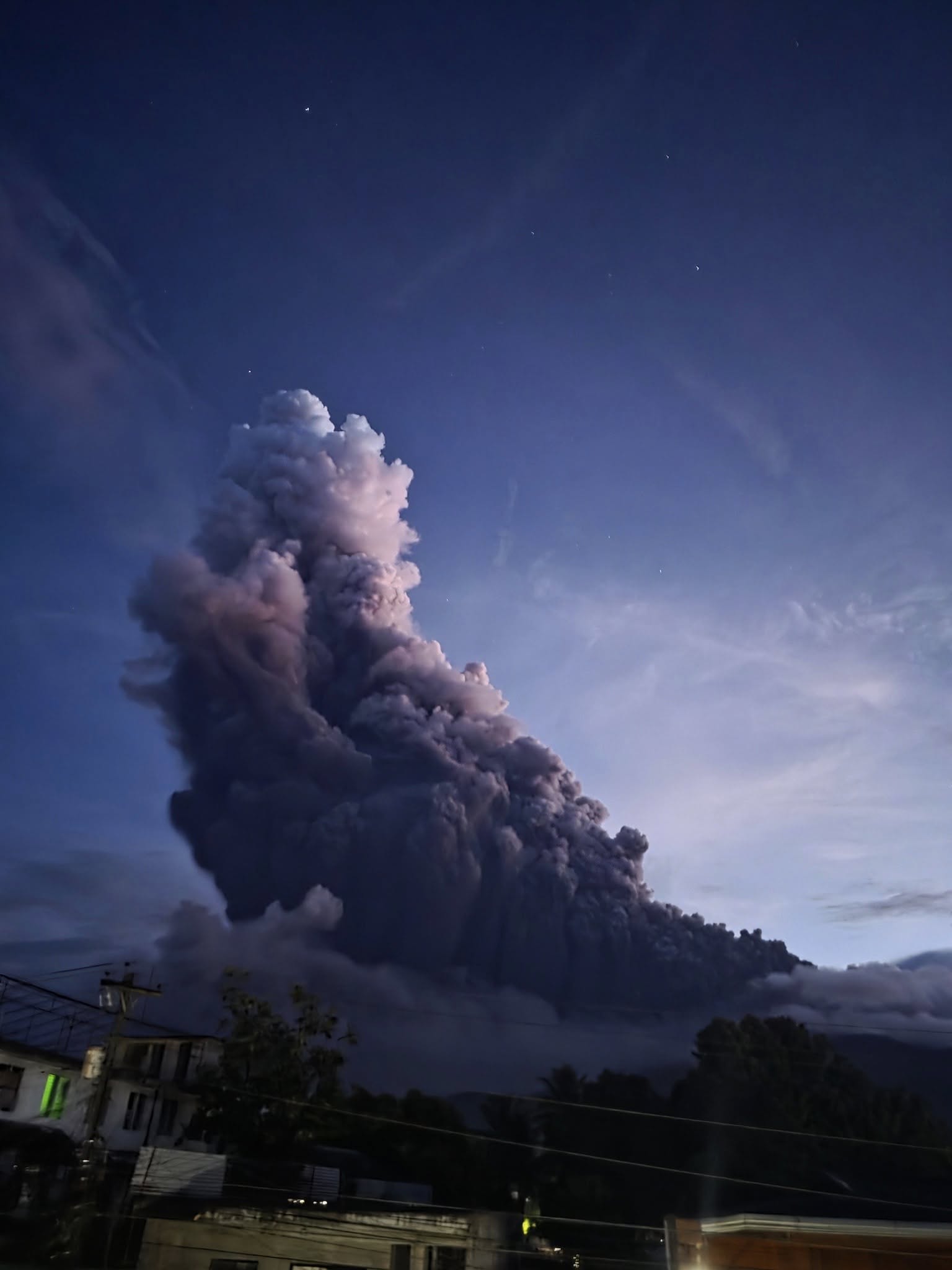
Indonesia , Dukono :
An eruption of Mount Dukono occurred on Tuesday, April 29, 2025, at 08:27 WIT with an observed ash column height of ± 1100 m above the peak (± 2187 m above sea level). The ash column was observed to be white to gray in color with moderate to thick intensity, oriented toward the east. At the time of writing, the eruption was still ongoing.
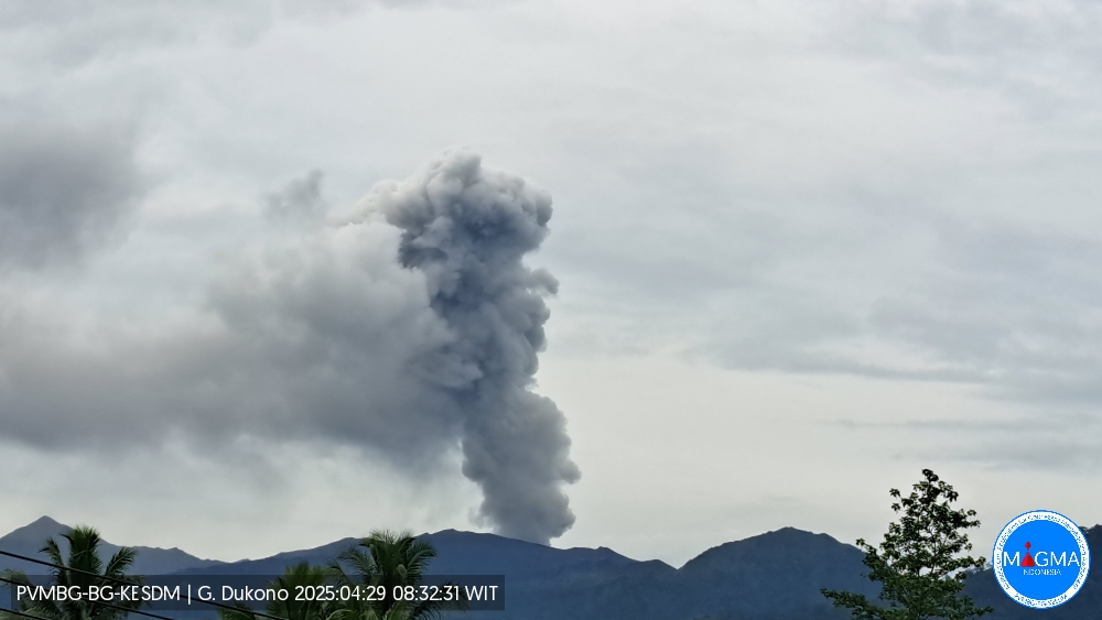
Seismicity Observation
189 eruption earthquakes with an amplitude of 6 to 34 mm and a duration of 33.9 to 154.87 seconds.
4 distant tectonic earthquakes with an amplitude of 10 to 34 mm and an earthquake duration of 94.74 to 161.27 seconds.
1 Continuous Tremor earthquake with an amplitude of 1-4 mm, dominant value 2 mm.
Recommendation
(1) People near Mount Dukono and visitors/tourists should not engage in activities, climb, or approach the Malupang Warirang Crater within a 4 km radius. (2) Since volcanic ash eruptions occur periodically and the distribution of ash follows the direction and speed of the wind, so the area where the ash lands is not constant, people around Mount Dukono are recommended to always carry masks/nose and mouth covers to use when needed to avoid the threat of volcanic ash to the respiratory system.
Source et photo : Magma Indonésie.
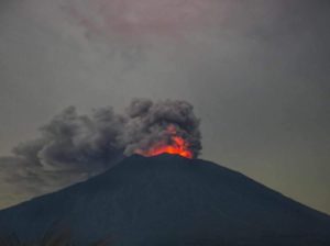
Chile , Lascar :
Seismology
The seismological activity for the period was characterized by the recording of:
6 VT-type seismic events, associated with rock fracturing (Volcano-Tectonic). The most energetic earthquake had a local magnitude (LM) value of 1.5, located 0.9 km east-southeast of the volcanic structure, at a depth of 1.9 km.
2 LP-type seismic events, associated with fluid dynamics within the volcanic system (Long Period). The size of the largest earthquake, estimated using the reduced displacement (RD) parameter, was 6 cm².
1 TR-type seismic event, associated with sustained fluid dynamics within the volcanic system (TRemor). The size of the earthquake, estimated using the reduced displacement (RD) parameter, was 2 cm². One TO-type seismic event, associated with fluid dynamics within the volcanic system, characterized by its distinctive waveform (TOrnillo). The earthquake size (DR) was 0.6 cm².
Fluid Geochemistry
Sulfur dioxide (SO2) emission data obtained using Differential Optical Absorption Spectroscopy (DOAS) equipment at the Emu station, located 6 km east-southeast (ESE) of the active crater, showed an average SO2 flux value of 1,073 t/d for the period under evaluation, with a maximum daily value of 1,666 t/d on April 14.
Fifteen anomalies were reported in satellite images obtained by the Tropospheric Monitoring Instrument (TROPOMI) regarding sulfur dioxide (SO2) emissions into the atmosphere in areas near the volcano. On April 2, the maximum emission value was recorded, reaching 139 tons of SO2 mass.
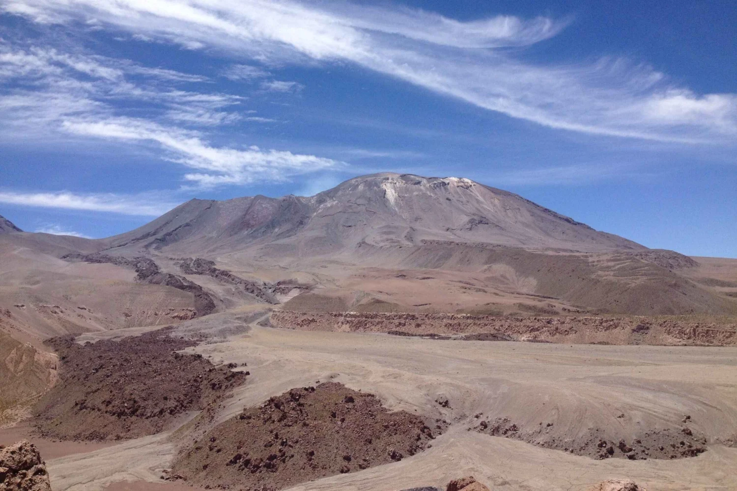
Satellite Thermal Anomalies
During the period, 36 thermal alerts were recorded in the area associated with the volcano, based on the MIROVA platform. The maximum values were 6.2 MW in MODIS (April 2). Sentinel 2-L2A satellite images from April 2, 7, and 12, combined across multiple bands, reveal a radiance pattern characterized by three zones within the active crater. Similarly, the total radiant area of the hotspot calculated by the NH (Normalized Hotspot Indices) platform reported 9,900 m² for April 13, a value considered moderate.
Surveillance Cameras
Images provided by surveillance cameras installed around the volcano, when weather conditions permitted, recorded white columns of degassing in a southeasterly direction, with the maximum value being 460 m above the crater on April 8 and 12. Incandescence is observed continuously during the nights of the period under evaluation.
Instrumental data suggest that the volcanic system remains in a context of anomalous internal and external activity. Seismic activity is remarkably low, lower than in previous periods, even absent for a few days this fortnight. Surface activity is characterized by continued incandescence and recurrent degassing, although with column heights lower than in the previous period. SO2 fluxes show daily averages below the threshold established as abnormal for this system. Satellite alerts related to atmospheric SO2 emissions, thermal anomalies, and radiation in the active crater persist, demonstrating the continuation of this anomalous process. It is hypothesized that the current cycle could be associated with a greater contribution from the magmatic component, evidenced by SO2 and persistent thermal anomalies, and could evolve towards states of greater activity.
Source : Sernageomin
Photo : Myguidechile . com
Ecuador , El Reventador :
DAILY STATUS REPORT OF REVENTADOR VOLCANO, Monday, April 28, 2025.
Information Geophysical Institute – EPN.
Surface Activity Level: High, Surface Trend: Ascending
Internal Activity Level: Moderate, Internal Trend: No change
From April 27, 2025, 11:00 a.m. to April 28, 2025, 11:00 a.m.:
Seismicity:
Below is the count of seismic events recorded at the reference station.
Explosion (EXP) 63
Long Period (LP) 8
Emission Tremor (TREMI) 17
Harmonic Tremor (TRARM) 4
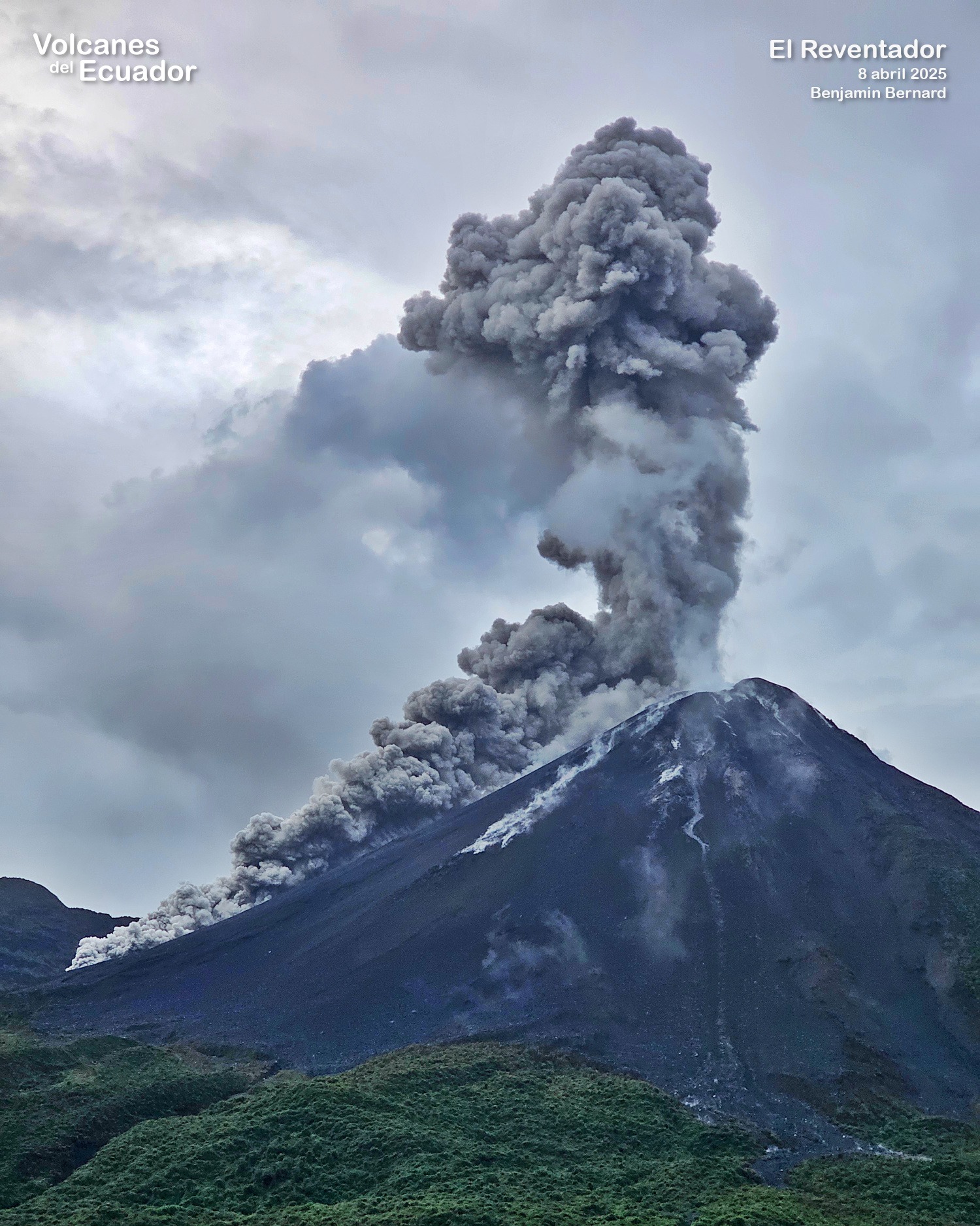
Rainfall/Lahars:
Precipitation was recorded in the volcano area without generating mudflows or debris flows. **Heavy rainfall could remobilize accumulated material, generating mudflows and debris flows that would cascade down the volcano’s flanks and flow into adjacent rivers.
Emission/Ash Column:
Yesterday afternoon, the surveillance camera system recorded several gas and ash emissions reaching heights of 1,000 to 1,800 meters above the crater in a southwesterly direction. Associated with this activity, the Washington VAAC agency issued four reports of ash clouds moving from west to southwest, with heights between 700 and 1,010 meters above the crater level.
Other monitoring parameters:
The FIRMS satellite system recorded four thermal anomalies, while the MIROVA-VIIRS satellite system recorded one weak thermal anomaly over the past 24 hours.
Observation:
Yesterday evening and early this morning, several episodes of incandescent material falling down the volcano’s flanks, up to 1,000 meters below the crater level, were recorded. At the time of writing, the volcano remains completely cloudy.
Alert Level – SGR: Orange
Source : IGEPN
Photo : Benjamin Bernard via volcanes ecuador / FB.