April 20, 2025.
Alaska , Spurr :
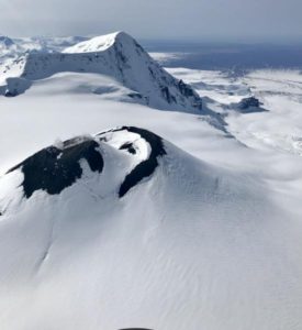
Unrest continues at Mount Spurr volcano. Seismicity remains elevated with occasional small volcanic earthquakes detected beneath the volcano over the past day. Satellite and web camera images from the past day showed continued steaming from the summit crater. This type of steaming is typical for Mount Spurr during this current period of unrest.
There were two non-volcanic earthquakes that were felt by residents throughout Southcentral Alaska over the past 12 hours. The first one at 11:19 PM AKDT yesterday evening was located southeast of Mount Spurr and the second one at 5:01 AKDT this morning was located under Cook Inlet west of Clam Gulch. Both of these earthquakes are due to typical tectonic activity and they are not due to activity at Mount Spurr. They will not cause additional unrest at the volcano, and unrest at the volcano will not cause an increase in this type of tectonic earthquake. The volcanic earthquakes that are occurring at Mount Spurr are too small to be felt, and even if an eruption were to occur it would not cause ground shaking in populated areas.
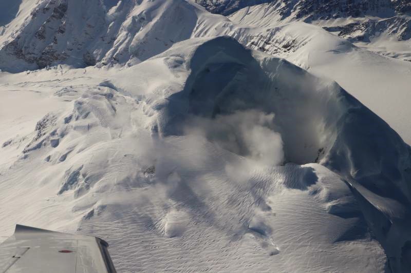
AVO continues monitoring activity at Mount Spurr for signals indicating that the volcano is moving closer to an eruption. Based on previous eruptions, changes from current activity in the earthquakes, ground deformation, summit lake conditions, and fumarolic activity would be expected if magma began to move closer to the surface. Therefore, if an eruption occurred, it would be preceded by additional signals allowing warning.
The volcano is monitored using local seismic, infrasound, web camera, and GNSS stations along with regional infrasound, lightning networks and satellite data.
Source : AVO
Photo : Kushner, Skye
Indonesia , Lewotobi Laki-laki :
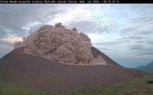
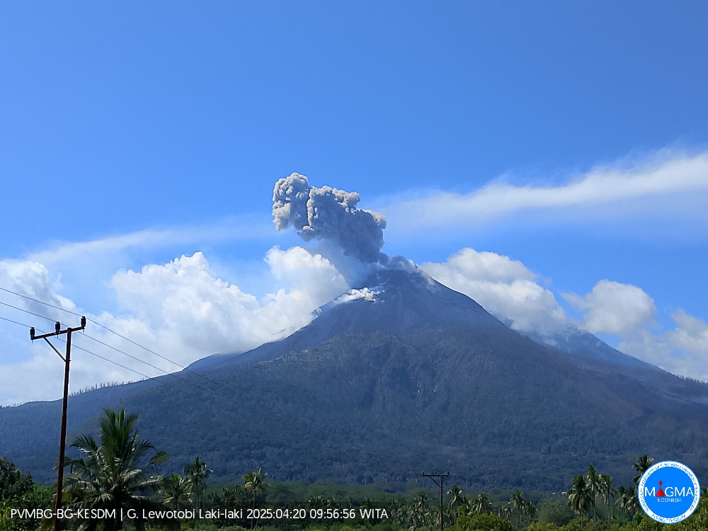
An eruption of Mount Lewotobi Laki-laki occurred on Sunday, April 20, 2025, at 09:55 WITA with an observed ash column height of ± 800 m above the peak (± 2384 m above sea level). The ash column was observed to be gray in color with a thick intensity, oriented toward the north and northeast. This eruption was recorded on a seismograph with a maximum amplitude of 22 mm and a duration of 76 seconds.
VOLCANO OBSERVATORY NOTICE FOR AVIATION – VONA
Issued : April 20 , 2025
Volcano : Lewotobi Laki-laki (264180)
Current Aviation Colour Code : ORANGE
Previous Aviation Colour Code : orange
Source : Lewotobi Laki-laki Volcano Observatory
Notice Number : 2025LWK258
Volcano Location : S 08 deg 32 min 20 sec E 122 deg 46 min 06 sec
Area : East Nusa Tenggara, Indonesia
Summit Elevation : 5069 FT (1584 M)
Volcanic Activity Summary :
Eruption with volcanic ash cloud at 01h55 UTC (09h55 local).
Volcanic Cloud Height :
Best estimate of ash-cloud top is around 7629 FT (2384 M) above sea level or 2560 FT (800 M) above summit. May be higher than what can be observed clearly. Source of height data: ground observer.
Other Volcanic Cloud Information :
Ash cloud moving from north to northeast. Volcanic ash is observed to be gray. The intensity of volcanic ash is observed to be thick.
Remarks :
Eruption recorded on seismogram with maximum amplitude 22 mm and maximum duration 76 second.
Source et photo : Magma Indonésie.
Colombia , Nevado del Ruiz :
Manizales, April 15, 2025, 4:00 p.m.
Monitoring the activity of the Nevado del Ruiz volcano, the Colombian Geological Survey (SGC), an entity affiliated with the Ministry of Mines and Energy, reports that:
During the week of April 8-14, 2025, the volcano continued to exhibit unstable behavior. Compared to the previous week, the main changes in the monitored parameters were:
– Seismicity related to fluid dynamics within the volcanic conduits decreased slightly in the number of recorded earthquakes and in the seismic energy released.
In addition, a decrease in long-period signals associated with continuous ash emission was observed. The energy levels of the seismic signals ranged from low to moderate. Using cameras (conventional or thermographic) used to monitor the volcano, it was possible to confirm some pulsed ash emissions associated with this seismic activity. Changes in the apparent temperature of the emitted material were also observed in relation to several ash emissions.
– Seismic activity associated with rock fracturing processes within the volcanic edifice decreased the number of recorded earthquakes and, slightly, the seismic energy released. Seismicity was located mainly on the northeast and distal northwest, southeast, and southwest flanks, and in the Arenas crater, at distances less than 10 km from the crater, and to a lesser extent, in the distal southwest and southeast sectors of the volcano, at distances up to 12 km from the crater. The depth of the earthquakes ranged from less than 1 km to 8 km from the volcano’s summit. The largest earthquake of the week was recorded on April 8 at 11:35 a.m., with a magnitude of 1.5, located 4 km northeast of the crater and 4 km deep.

Additionally, low-energy seismic activity was recorded, linked to the activity of the lava dome (prominence or mound) located at the crater floor.
– The emission of water vapor and gases, primarily sulfur dioxide (SO₂), into the atmosphere from the Arenas crater was variable. Estimated values of the daily SO₂ outgassing flux showed an increase compared to the previous week, mainly due to atmospheric conditions favorable for data collection. Satellite monitoring, which is being carried out to complement the assessment of this parameter, continues to show significant SO₂ releases.
– The vertical height of the gas column remained mainly below 700 m measured above the volcanic summit, with a maximum of 1200 m. In dispersion, the column also reached a maximum value of 1200 m during the gas and ash emission on April 12 at 8:52 p.m. The dispersal direction showed a preferential trend toward the northwest and west-northwest flanks of the volcano throughout the week, generating ashfall in the area known as Valle de las Tumbas, within Los Nevados National Natural Park.
– During monitoring of thermal anomalies at the floor of Arenas Crater using satellite monitoring platforms, some reports of low to moderate energy levels were obtained.
Source et photo : SGC
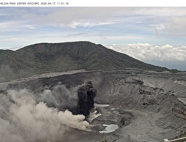
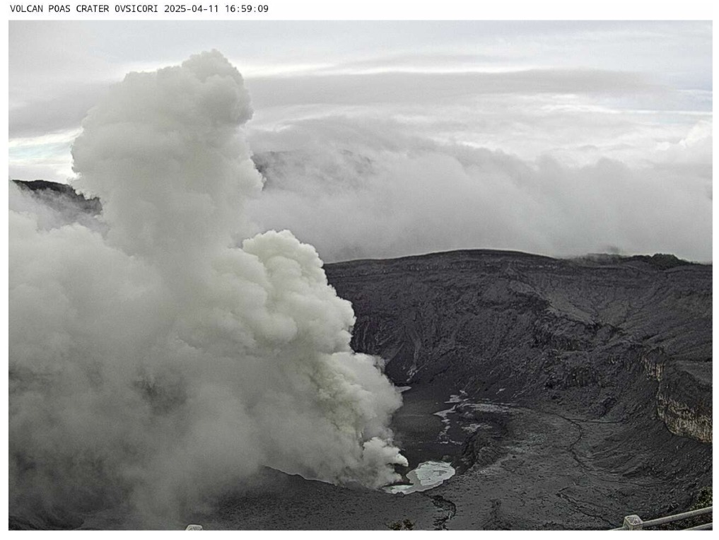
Costa Rica , Poas :
This week, the seismic signal was dominated by eruptive activity. Seismic tremor increases during periods when the acoustic pulses of eruptions are energetic, however, the height of the eruptions is low (< 100 m). Conversely, the amplitude of seismic tremor decreases when medium-height eruptions occur (< 500 m), which are acoustically manifested by mainly short tremors. Before the highest eruptions (> 1000 m), a decrease in eruptive activity is observed. The eruption on the 8th at 6 a.m. was characterized by a short spasmodic tremor. These observations indicate temporary blockages before major events. Regarding volcano-tectonic seismicity, very few events were recorded this week. However, an increase in proximal earthquakes (classified as « high frequency ») is observed. These events may be associated with the rupture of rocks very close to the crater. The number of long-running events also increased this week.
Geodetic monitoring has detected moderate vertical uplift of the volcano, affecting the immediate crater area as well as the remaining GNSS stations located at the summit. This uplift is the most significant observed so far in the current eruptive cycle, which began in December 2024. A stabilization of the vertical movement has been recorded in recent days.
The SO2 flux measured by the DOAS station decreased this week (223 ± 210 t/d) compared to the previous week (521 ± 354 t/d). However, the wind direction was not optimal for calculating the emission. Furthermore, a maximum SO2 flux of 5,524 ± 854 t/d was measured on April 9 by the mobile DOAS. The OMI instruments on the SENTINEL satellite continue to detect significant amounts of SO2 daily. A peak was recorded on April 7 and 8 with values exceeding 1,000 tons of SO2.
On April 9, at the foot of the Mirador, a low-temperature fumarole field (42-50 degrees Celsius) with water vapor emanation and yellow mineral deposits was visually observed. In May 2023, a slight thermal anomaly at this site, ranging from 27 to 54 degrees Celsius, was observed remotely using a drone (I. Godfrey, pers. comm. 2023).
The ash emitted this week does not show a significant increase in the proportion of juvenile material (fresh magma glass fragments). Winds altered the ash dispersal pattern this week, particularly on April 8, which particularly affected the southern part of the volcano. Furthermore, the energetic eruptions of April 6 and 8 launched ballistic debris (rock fragments) over 20 cm wide that reached the crater rim to the southeast and northwest up to a horizontal distance of 500 m, leaving traces of small impact craters. In the region between the periphery of the active crater and the entrance to the PNVP, a homogeneous layer of fine gray ash, at least 1 to 2 mm thick, was deposited. Around the eruptive vent at the floor of the active crater, up to 6 m of ash accumulated in one week, but this cannot be measured below the plume. Light ashfall, sulfur odors, and some impact on human and animal health have been reported, as well as effects on vegetation and crops in the middle and upper parts of the western flank of the volcanic massif, as well as in towns such as San Luis and Trojas de Grecia.
Source et photo : Ovsicori .
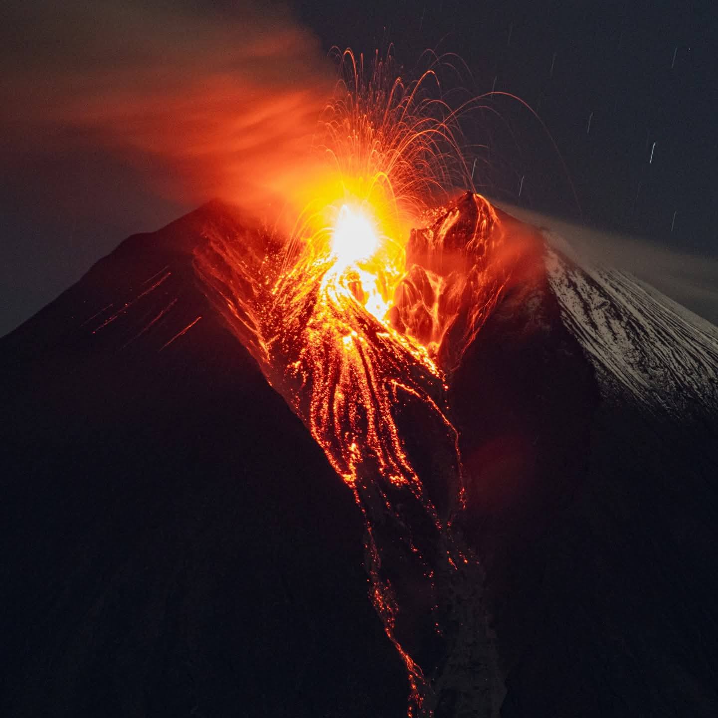
Ecuador , Sangay :
SANGAY VOLCANO DAILY STATUS REPORT, Saturday, April 19, 2025.
Information Geophysical Institute – EPN.
Surface Activity Level: Moderate, Surface Trend: Ascending
Internal Activity Level: Moderate, Internal Trend: No Change
Seismicity: From April 18, 2025, 11:00 a.m. to April 19, 2025, 11:00 a.m.:
Seismicity:
Below is the count of seismic events recorded at the reference station.
Explosion (EXP): 57
Rainfall/Lahars:
No rainfall has been recorded in the volcano area. **Heavy rainfall could remobilize accumulated material, generating mud and debris flows that would cascade down the volcano’s flanks and flow into adjacent rivers.
Emission/Ash Column:
This morning, the surveillance camera network recorded several gas and ash emissions reaching heights of up to 3,000 meters above the crater, in west and northwest directions. Meanwhile, the GOES-19 satellite system has recorded several gas and ash trails reaching heights of less than 1,000 meters above the crater, in a west and northwest direction since yesterday afternoon. In connection with these emissions, the Washington VAAC issued four reports of ash clouds moving west and west-northwest with heights ranging from 600 to 3,000 meters above the crater level. Furthermore, due to these emissions, yesterday afternoon (1:30 PM LT), thanks to information from the Volcano Observer Network (ROVE), a light ash fall was reported in the village of Cebadas, Guamote Canton, Chimborazo Province.
Other monitoring parameters:
The FIRMS satellite system recorded 10 thermal anomalies, and the MIROVA-VIIRS satellite system recorded one thermal anomaly in the last 24 hours.
Observation:
Despite cloud cover in the area, surveillance cameras recorded incandescence and the emission of incandescent material up to 200 meters above the crater early this morning. At the time of writing, the volcano remains completely cloudy.
Alert Level: Yellow
Source : IGEPN
Photo : Cristopher Cardenas / Volcan Sangay / FB.