January 08 , 2020 .
Italy / Sicily , Etna :
Weekly Bulletin from December 30, 2019 – January 05, 2020 (issue date January 07, 2020)
SUMMARY OF THE STATUS OF THE ACTIVITY
In light of the monitoring data, it is underlined:
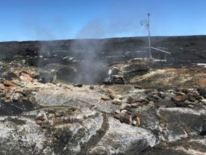
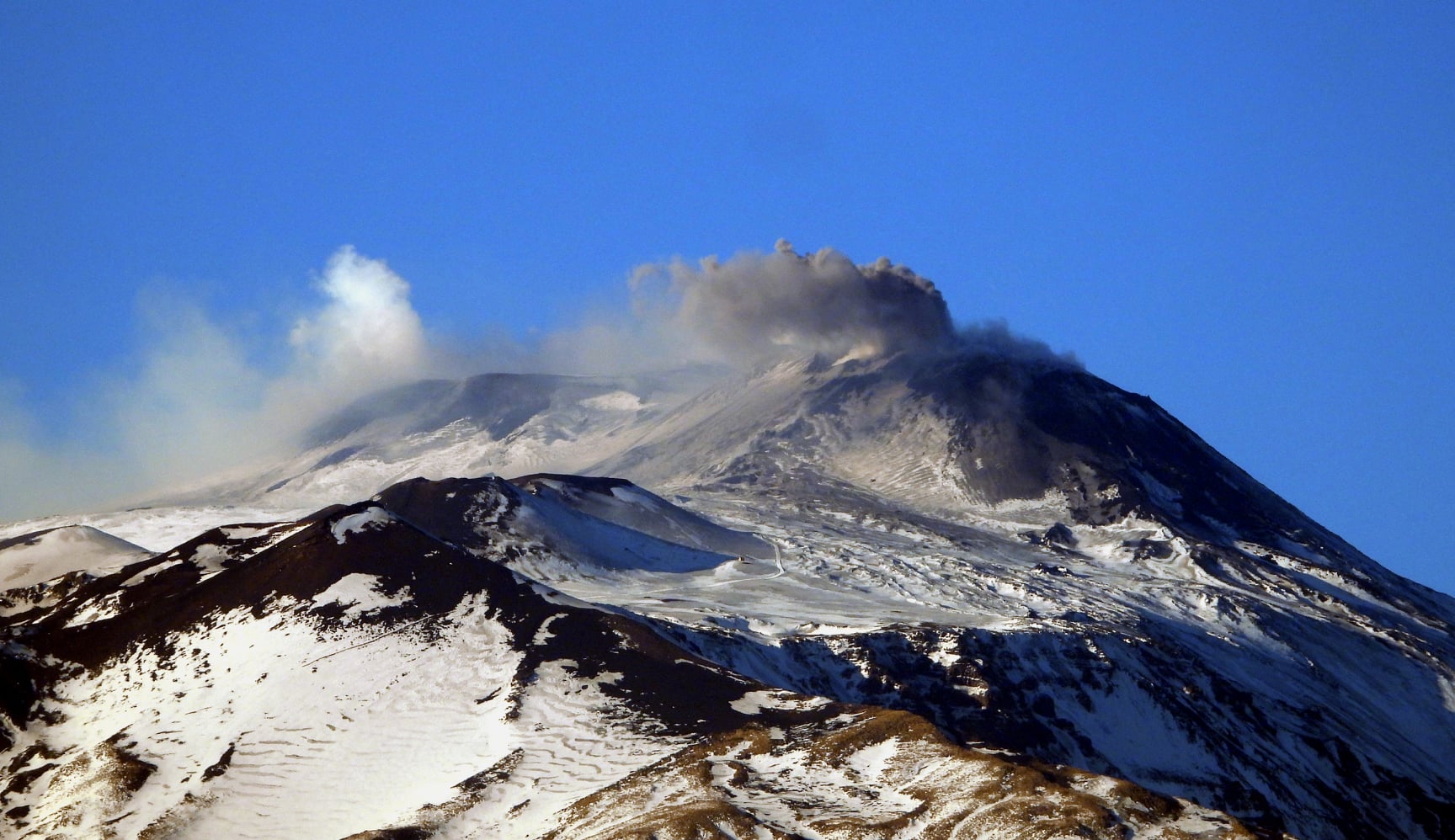
1) VOLCANOLOGICAL OBSERVATIONS: Explosive activity at the New Southeast Crater and at the Bocca Nuova with low ash emissions which disperse rapidly in the summit area.
2) SEISMOLOGY: Low seismic activity, no Ml = 2 or higher event. Amplitude of volcanic tremor at medium – high levels.
3) INFRASOUND: Low infrasound activity, except January 04, 2020
4) DEFORMATIONS: No significant variation to report.
5) GEOCHEMISTRY: the fluxes of SO2 and HCl are at a medium-low level. The flow of CO2 to the soil shows a moderate increase compared to the previous week, but it remains on average values. The partial pressure of CO2 in the aquifer does not show significant variations. The isotopic ratio of helium is at medium-high values (last data available on December 12).
VOLCANOLOGICAL OBSERVATIONS
The volcanic activity of the summit craters of Etna was monitored during the week by analyzing images from the INGV surveillance camera network – Catania Section, Etneo Observatory (INGV -o) . Adverse weather conditions only permitted limited observations.
The New Southeast Crater and Bocca Nuova were affected by very dilute ash emissions which dispersed rapidly in the summit area. The Northeast crater and the Voragine crater were mainly affected by a degassing activity … / …
Seismology:
Seismicity: in the week from 31.12.2019 to 5.1. The seismic activity of 2020 was weak. No event with Ml = 2 or higher has been recorded.
Volcanic tremor: The amplitude of volcanic tremor remained at average levels, with a slight increase towards medium-high levels at the end of the week. The locations of the springs are located northeast of the central craters, with depths between 1.5 and 2.5 km above sea level.
Read the article: file:///C:/Users/Utilisateur/AppData/Local/Packages/Microsoft.MicrosoftEdge_8wekyb3d8bbwe/TempState/Downloads/BollettinoEtna20200107%20(1).pdf
Source : INGV
Alaska , Shishaldin :
AVO/USGS Volcanic Activity Notice
Current Volcano Alert Level: WATCH
Current Aviation Color Code: ORANGE
Issued: Tuesday, January 7, 2020, 9:39 AM AKST
Source: Alaska Volcano Observatory
Notice Number: 2020/A6
Location: N 54 deg 45 min W 163 deg 58 min
Elevation: 9373 ft (2857 m)
Area: Aleutians
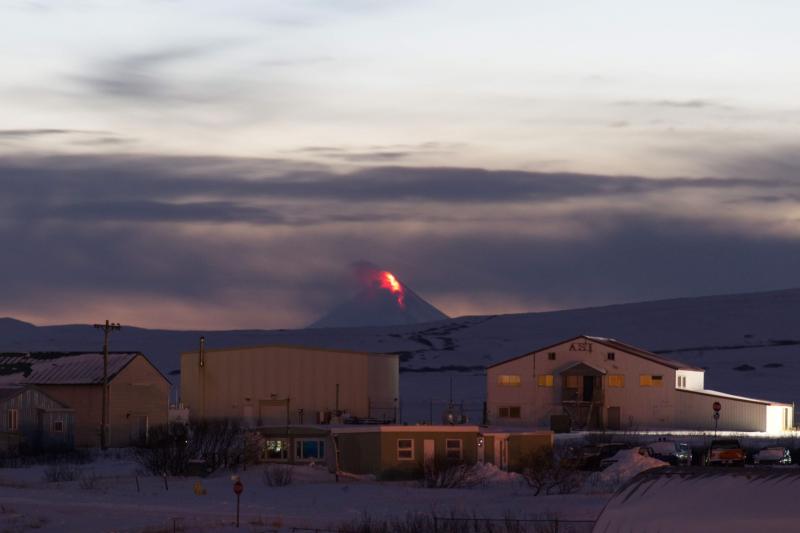
Shishaldin Volcano in eruption, January 6, 2020, as seen from Cold Bay, about 58 mi NE of Shishaldin.
Volcanic Activity Summary:
Elevated seismicity since a little after 5:00 AM AKST today is continuing and likely accompanied by ash emissions. A volcanic cloud is visible in satellite data as high as about 23,000 ft asl drifting to the east-northeast of the volcano. Strongly elevated and saturated surface temperatures in satellite imagery are indicative of active lava effusion at the summit vent. Shishaldin remains at Aviation Color Code ORANGE and Alert Level WATCH.
The National Weather Service has issued a SIGMET to 23,000 ft above sea level (https://www.weather.gov/aawu/).
It is possible for the current activity to intensify or decrease with little warning. AVO will issue further information as warranted.
Shishaldin is monitored by local seismic and infrasound sensors, satellite data, a web camera, a telemetered geodetic network, and distant infrasound and lightning networks.
Recent Observations:
[Volcanic cloud height] Up to 23,000 ft asl
[Other volcanic cloud information] Drifting ENE
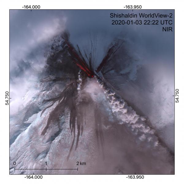
WorldView-2 multispectral satellite image of Shishaldin Volcano acquired on January 3, 2020 at 22:22 UTC. This image was taken a few hours after an explosion, which deposited ash on the southern flanks of the volcano. Lava flows are visible in the near-infrared to the northwest (active, extending >1.6 km from vent) and northeast (inactive flow from yesterday, 1.2 km long). An ash plume is visible erupting from the summit. Dark pyroclastic flows can be seen on the western and southern flanks reaching lengths of up to 2.6 km.
Issued: Tuesday, January 7, 2020, 12:33 PM AKST
Current Aviation Color Code: RED
Previous Aviation Color Code: ORANGE
Volcanic Activity Summary:
Ash eruption at Shishaldin continues and has intensified as shown in satellite and lightning data. Satellite data suggest the ash cloud is as high as 27,000 ft asl and drifting east-northeast. Aviation Color Code is RED and Alert Level is WARNING.
Issued: Tuesday, January 7, 2020, 7:17 PM AKST
Current Aviation Color Code: ORANGE
Previous Aviation Color Code: RED
Volcanic Activity Summary:
Ash emissions have declined significantly since about 12:00 PM AKST (21:00 UTC). The Aviation Color Code is lowered to ORANGE and Alert Level to WATCH.
Seismicity is currently low. Satellite data from this afternoon suggest continued low-level eruptive activity. It is possible for more explosive activity to resume with little warning.
Remarks:
Shishaldin volcano, located near the center of Unimak Island in the eastern Aleutian Islands, is a spectacular symmetric cone with a base diameter of approximately 16 km (10 mi). A 200-m-wide (660 ft) funnel-shaped summit crater typically emits a steam plume and occasional small amounts of ash. Shishaldin is one of the most active volcanoes in the Aleutian volcanic arc, with at least 54 episodes of unrest including over 24 confirmed eruptions since 1775. Most eruptions are relatively small, although the April-May 1999 event generated an ash column that reached 45,000 ft above sea level.
Source : AVO.
Photos : Aaron Merculief , Dietterich, Hannah .
Colombia , Nevado del Huila :
Weekly activity report of the volcano Nevado del Huila
The activity level of the volcano continues at the level: Activity level Yellow or (III): changes in the behavior of volcanic activity.
From the analysis and evaluation of information obtained through the Nevado del Huila volcano monitoring network during the week of 31 December 2019 to 6 January 2020, the GEOLOGICAL SERVICE COLOMBIAN – vulcanologique Seismological Observatory and Popayan reports that :
• During the evaluation period, 429 seismic events were recorded, of which 192 were related to rock fracturing process (type VT) and 237 to fluid dynamics in volcanic conduits. Of these, 230 were classified as long period type events (LP type), four (4) as hybrid types (HB type) and three (3) as low energy tremor pulses (TR type).
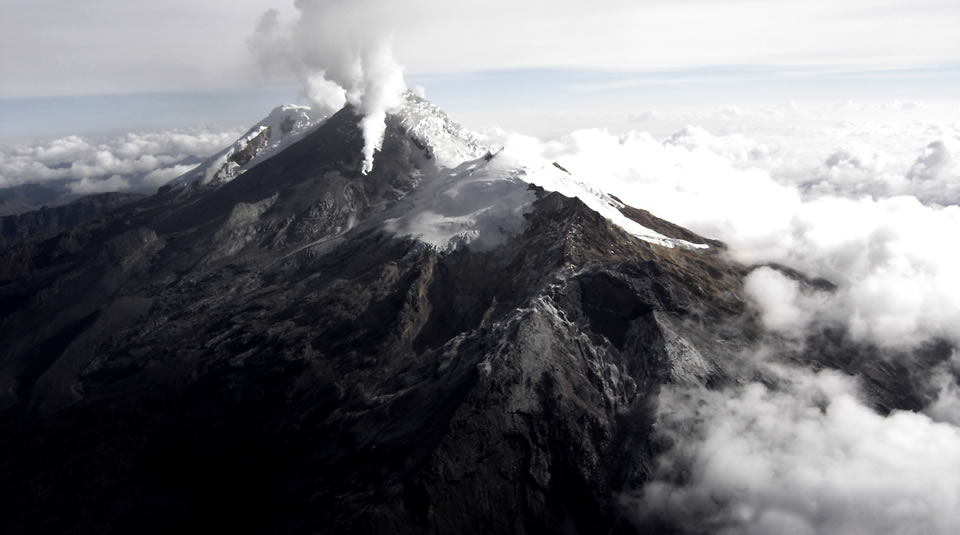
• The images obtained during the week via the webcams of Caloto, Tafxnú, Maravillas and La Palma showed little degassing of the volcanic system.
• The sensors for monitoring soil deformation, magnetic fields and infrasonic waves did not record variations associated with changes in volcanic activity.
Therefore, it is concluded that during the evaluated period, the volcano continued to exhibit stable behavior. The Colombian Geological Survey remains attentive to the evolution of the volcanic phenomenon and will inform in a timely manner any changes that may occur.
Source : Ingeominas.
Photo : Parque Nacional .
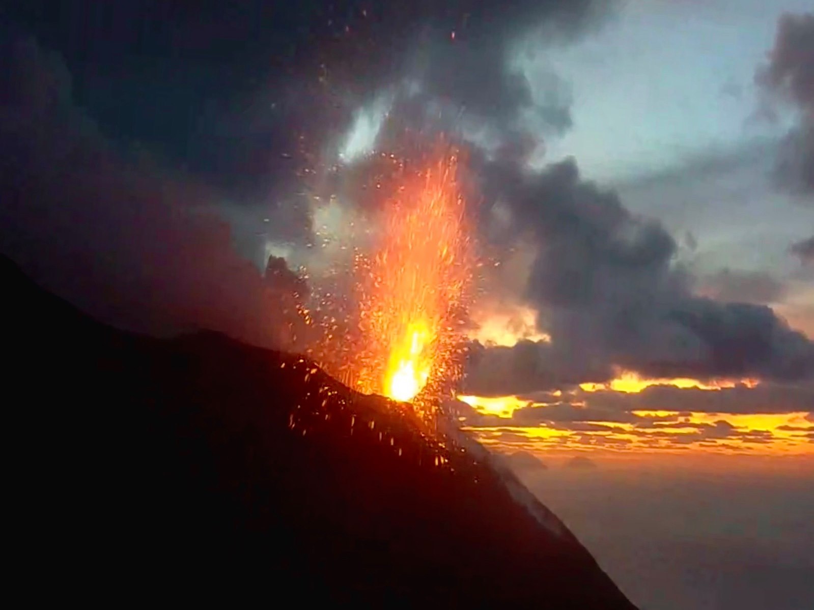
Italy , Stromboli :
Weekly Bulletin from December 30, 2019 – January 05, 2020 (issue date January 07, 2020)
SUMMARY OF THE STATUS OF THE ACTIVITY
In light of the monitoring data, it is underlined:
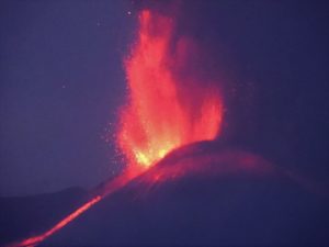
1) VOLCANOLOGICAL OBSERVATIONS: During this period, normal Strombolian type explosive activity was observed, accompanied by degassing and splashing activities. The hourly frequency of explosions fluctuated between medium-high values (16 events / h on January 5) and very high values (26 events / h on January 1). The intensity of the explosions was mainly medium-low in the area of the North crater and medium in the area of the Center-South crater.
2) SEISMOLOGY: The seismological parameters do not present significant variations.
4) DEFORMATIONS: no change to report
5) GEOCHEMISTRY: the flow of SO2 is at a medium-high level. No update is available on the isotopic ratio of helium in the aquifer. The last values (sampling of 12/19/2019) are medium-low. The CO2 / SO2 ratio in the plume, since the last update of 05/01/2020, is at a medium-high value.
VOLCANOLOGICAL OBSERVATIONS:
The analysis of the images recorded by the cameras placed at an altitude of 400m, at an altitude of 190m and at Punta dei Corvi made it possible to characterize the eruptive activity of Stromboli. During the reporting period, the explosive activity was mainly produced by at least three eruptive vents located in the area of the North crater and by at least three eruptive vents located in the area of the Center-South crater. All the vents are located inside the depression which occupies the crater terrace.
In the northern zone, the explosions were mainly low (less than 80 m high) and medium (less than 150 m high), sometimes high (greater than 150 m high), emitting coarse materials (lapilli and bombs). In numerous explosions, the fallout covered the outer slopes of the area overlooking the Sciara del Fuoco and a few blocks rolled for a few hundred meters before the mesa in place along the Sciara. Splashes were observed in the mouths located in the southern part of the North zone, which were intense from December 31 to January 3, 2020. The average frequency of explosions in the North zone varied between 8 and 15 events / h.
The explosive activity of the Center-South zone produced explosions of coarse matter mixed with fine ash, of medium intensity (less than 150 m high), during certain explosions the products fell in the upper part of the Sciara . The frequency of explosions of South Central area varied between 7 and 12 events / h with the exception of January 5 when the average rate was less than 1 event / h … / …
The amplitude of the volcanic tremor showed generally medium-low values.
Source : INGV.
Lire l’article : file:///C:/Users/Utilisateur/AppData/Local/Packages/Microsoft.MicrosoftEdge_8wekyb3d8bbwe/TempState/Downloads/BollettinoStromboli20200107%20(1).pdf