April 13 , 2025.
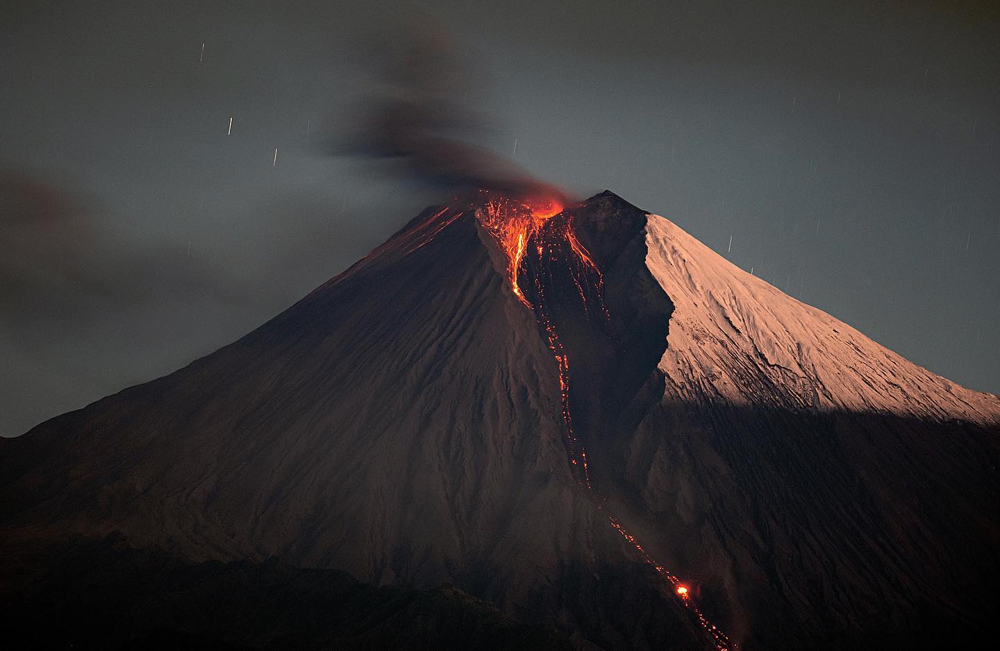
Italy / Sicily , Etna :
Etna Activity Statement, April 12, 2025, 8:47 AM (6:47 UTC).
The National Institute of Geophysics and Volcanology, Osservatorio Etneo, reports that surveillance cameras show that Strombolian activity has ended and that the lava flow reported in the previous press release has exhausted itself and is cooling.
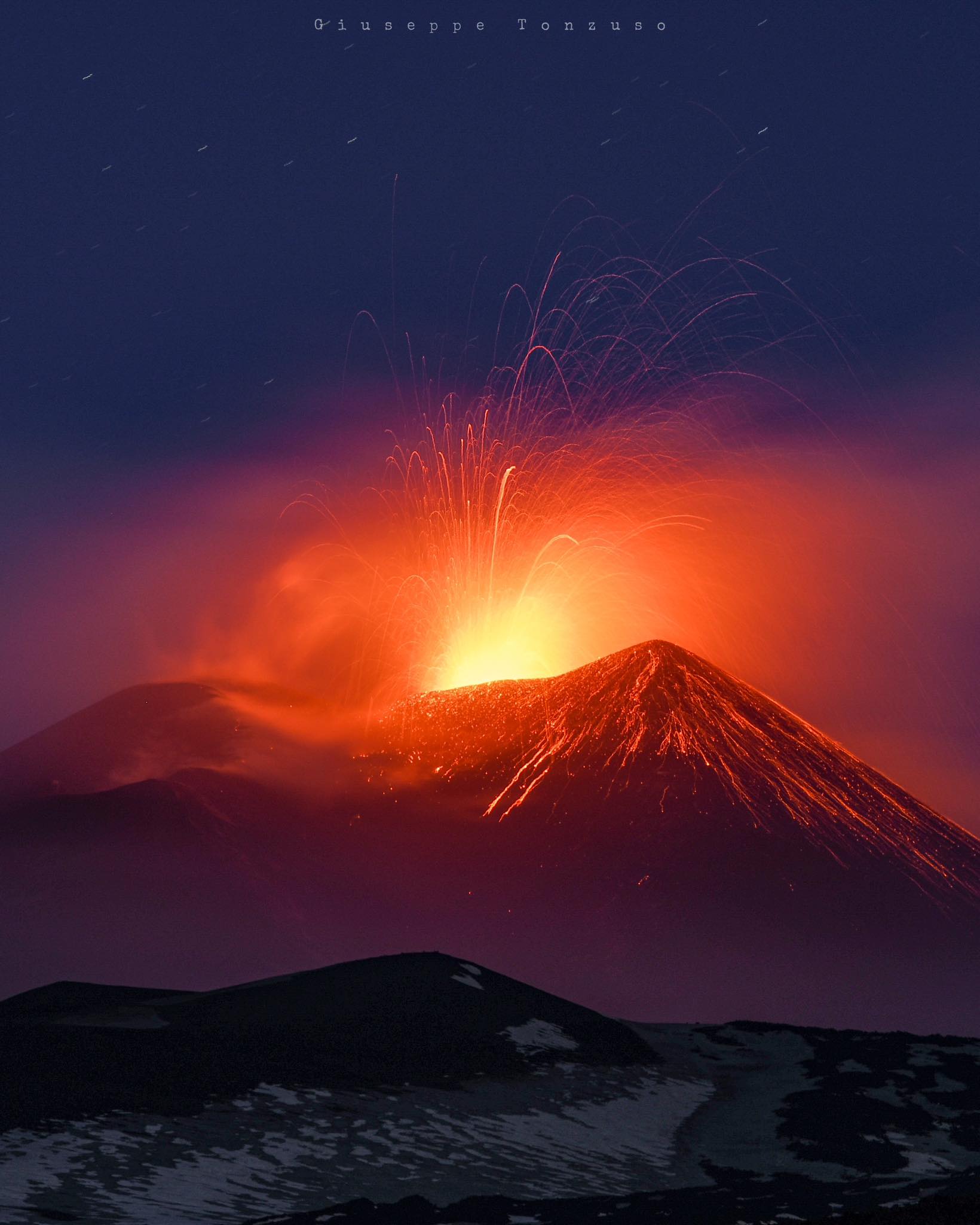
The tremor amplitude has returned to a low level since the early hours of today.
The centroid of the tremor sources is located in the central crater area. Low infrasound activity. Signals recorded by deformation monitoring networks show no significant variations.
Further updates will be provided shortly.
Source : INGV.
Photo : Giuseppe Tonzuso.
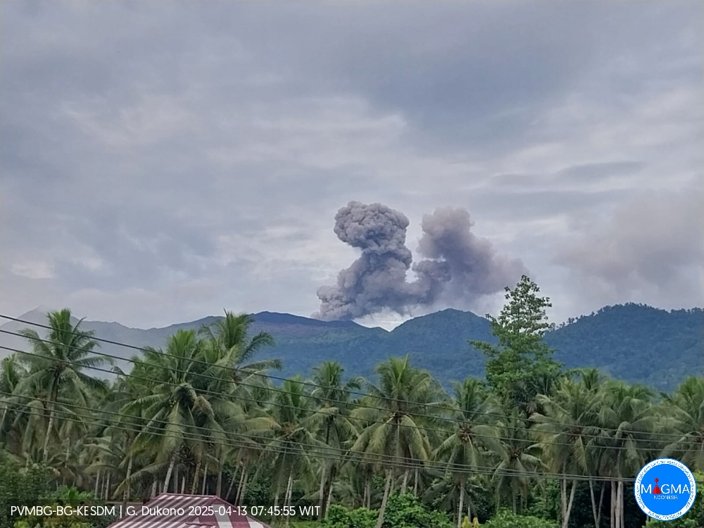
Indonesia , Dukono :
An eruption of Mount Dukono occurred on Sunday, April 13, 2025, at 07:33 WIT with an observed ash column height of ± 900 m above the peak (± 1987 m above sea level). The ash column was observed to be white to gray in color with a thick intensity, oriented northwest. This eruption was recorded on a seismograph with a maximum amplitude of 28 mm and a duration of 46.31 seconds.
Seismicity Observation:
222 eruption earthquakes with an amplitude of 5 to 34 mm and a duration of 32.98 to 57.35 seconds.
1 Continuous Tremor earthquake with an amplitude of 2-5 mm, with a dominant value of 3 mm.
Recommendation
Communities around Mount Dukono and visitors/tourists are advised not to carry out activities, climb, or approach the Malupang Warirang crater within a 4 km radius.
Considering that volcanic ash eruptions occur periodically and that the ash distribution follows the direction and speed of the wind, so that the ash area is not fixed, it is recommended that people around Mount Dukono always wear masks/nose and mouth coverings to use when needed to avoid the threat of volcanic ash to the respiratory system.
Source et photo : Dukono .
Colombia , Nevado del Ruiz :
Manizales, April 8, 2025, 5:15 p.m.
Monitoring the activity of the Nevado del Ruiz volcano, the Colombian Geological Survey (SGC), an entity affiliated with the Ministry of Mines and Energy, reports that:
During the week of April 1-7, 2025, the volcano continued to exhibit unstable behavior. Compared to the previous week, the main variations in the monitored parameters were:
– Seismicity related to fluid dynamics in volcanic conduits increased in the number of recorded earthquakes and decreased in the seismic energy released, with the exception of seismic signals associated with the continuous emission of ash, which showed an increase in energy during April 4. The energy levels of the seismic signals ranged from low to moderate. Using cameras (conventional or thermographic) used to monitor the volcano, it was possible to confirm some continuous and pulsed ash emissions associated with this seismic activity. Changes in the apparent temperature of the emitted material were also observed in relation to several ash emissions.
– Seismic activity associated with rock fracturing processes within the volcanic edifice increased the number of recorded earthquakes and slightly decreased the released seismic energy. Seismic activity was mainly located in the Arenas crater and on the northeast and southeast flanks, at distances less than 6 km from the crater, and to a lesser extent, in the southwest and west sectors of the volcano, at distances up to 11 km from the crater. The depth of the earthquakes ranged from less than 1 km to 7 km from the volcano’s summit. The largest earthquake of the week was recorded on April 5 at 7:49 a.m., with a magnitude of 1.2, located 5 km northeast of the crater and at a depth of 5 km. Additionally, low-energy seismic activity was recorded, linked to the activity of the lava dome (protuberance or mound) located at the crater floor.
– From the Arenas crater, the emission of water vapor and gases, mainly sulfur dioxide (SO₂), into the atmosphere was variable. Estimated daily SO₂ outgassing flux values remained similar to the previous week, due to persistent atmospheric conditions in the region, with high cloud cover and wind direction, which do not favor data collection. Satellite monitoring, which is carried out to complement the assessment of this parameter, continues to show significant SO₂ releases.
– The height of the gas or ash column was 1,700 m vertically and 2,000 m dispersed. These values, measured at the volcano’s summit, were estimated during the gas and ash emission on April 5 at 1:53 a.m. The dispersion direction showed a preferential trend toward the west-southwest and west-northwest of the volcano.
– During monitoring of thermal anomalies at the floor of Arenas Crater using satellite monitoring platforms, some reports of low energy levels were obtained. The heavily cloudy atmospheric conditions in the area did not facilitate their detection.
Source : SGC
Photo : COLOMBIAN AIR FORCE
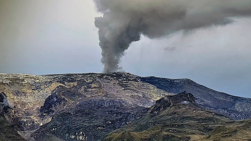
Ecuador , Sangay :
SANGAY VOLCANO DAILY STATUS REPORT, Saturday, April 12, 2025.
Information Geophysical Institute – EPN.
Surface Activity Level: Moderate, Surface Trend: No change
Internal Activity Level: Moderate, Internal Trend: No change
Seismicity: From April 11, 2025, 11:00 a.m. to April 12, 2025, 11:00 a.m.:
Seismicity:
Below is the count of seismic events recorded at the reference station.
Explosion (EXP): 87
Rainfall/Lahars:
No rainfall has been recorded in the volcano area. **Heavy rainfall could re-mobilize accumulated material, generating mud and debris flows that would cascade down the volcano’s flanks and flow into adjacent rivers.
Emission/Ash Column:
Since yesterday afternoon, several gas and ash emissions have been recorded through the surveillance camera network at heights between 800 and 2000 meters above the crater level in southwest, east, and southeast directions. Associated with this activity, the Washington-based VAAC agency has released five ash emission reports with heights of 900, 1200, 1500, and 1800 meters above the crater level in southwest and west directions.
Other monitoring parameters:
The FIRMS satellite system recorded 15 thermal anomalies, and the MIROVAMODIS satellite system recorded one thermal anomaly over the past 24 hours.
Observation:
In the early morning, several episodes of incandescence were recorded at the crater. Similarly, ECU-911 surveillance cameras observed the expulsion of incandescent ballistic projections toward the southeast ravine. At the time of writing, the volcano was cloudy.
Alert level: Yellow
Source : IGEPN
Photo : Eqphos_fotografía
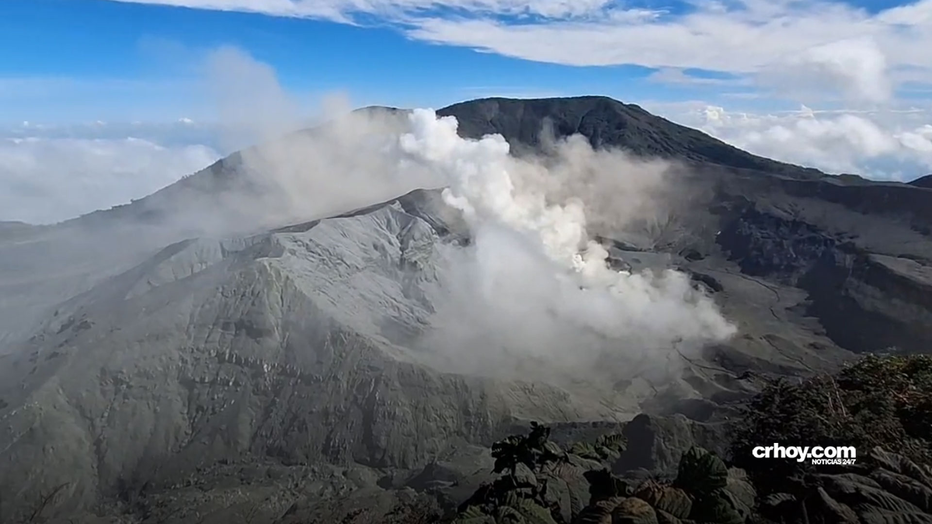
Costa Rica , Poas :
Daily Volcano Status Report. OVSICORI-UNA
Date: April 12, 2025, Updated at: 1:06:00 PM.
Latitude: 10.2
Longitude: -84.233
Altitude: 2,687 meters
Observed Activity:
Eruptive activity at Poás continues continuously, with plumes rich in gas, water vapor, ash, and rock rising to heights between 100 and 400 meters from the crater floor. Seismographs and infrasound sensors record volcanic tremor and acoustic signals continuously, with variations in signal amplitudes related to periods of partial conduit blockage and periods of partial conduit opening. Today, April 12, at approximately 2:28 a.m. local time, a tremor signal and acoustic infrasound were recorded, indicating a short-lived eruptive pulse, slightly more energetic than the numerous eruptive pulses that the volcano already displays continuously. The plume height of this pulse cannot be estimated due to cloudy conditions at the volcano’s summit. The SENTINEL satellite detected significant masses of SO2 gas emitted by Poás between March 30 and 31 (2,200 tons of SO2) and April 8 (1,300 tons). The OVSICORI-UNA air quality reference station located in Coronado San José detected SO2 gas from Poás Volcano between 4 and 19 parts per billion (ppb) between April 7 and 8. On the other hand, the LAQAT-UNA gas and particle analyzer located on the roof of the Poás Volcano National Park visitor building detected ambient air SO2 concentrations between April 7 and 8, between 3,000 and 6,000 ppb, two orders of magnitude higher than the SO2 gas concentrations detected in Coronado.
Residents of Poás, Grecia, and Zarcero report a sulfur odor and symptoms such as headaches, nausea, sore throat, watery eyes, runny nose, and allergies related to the emissions of volcanic gases and particles from the Poás volcano.
Environmental Conditions:
Winds at the summit of Poás blow from the west-southwest.
Environmental Conditions:
The prevailing wind at the summit of Poás is east-northeast at 37 km/h at the time of this report (IMN). Residents west of the volcano report illnesses in humans and animals (sore throat, headache, watery eyes, runny nose, allergies). To protect yourself from the ash, keep pets indoors. Adults without respiratory problems can use N95 or FFP2 masks. Protect water and food intended for human and animal consumption from ash, as it contains fluoride, which is very harmful to the bones and teeth of animals and humans.
Activity Level: Caution (3)
Source : Ovsicori.
Photo : Crhoy . Com