February 19 , 2025.
Italy / Sicily , Etna :
WEEKLY BULLETIN, from February 10, 2025 to February 16, 2025. (issue date February 18, 2025)
SUMMARY OF ACTIVITY STATUS
In light of monitoring data, it is highlighted:
1) VOLCANOLOGICAL OBSERVATIONS: Effusive activity from an eruptive fissure at the base of the Bocca Nuova crater, Strombolian activity and volcanic ash emission at the Southeast crater and degassing at the Bocca Nuova, Voragine and Northeast crater.
2) SEISMOLOGY: Increased rate of occurrence of fracturing earthquakes and energy releases. Average amplitude of volcanic tremor at a high level.
3) INFRASOUND: Moderate infrasound activity with sources located in the area of the Southeast Crater (SEC).
4) GROUND DEFORMATIONS: Over the past week, the ground deformation monitoring networks have recorded a progressive deflation at the summit inclinometer station of the Piano Crater (CDP) and the Monte Ruvolo stress detector (DRUV), during the ongoing subterminal eruption.
5) GEOCHEMISTRY: SO2 flux at medium-high level
Soil CO2 flux (EtnaGas Network) on average values.
The partial pressure of dissolved CO2 in the aquifer (Ponteferro) shows values within seasonal variability.
Isotopic ratio of peripheral sites: no updates. Latest data (31/01/2025) on medium-high values.
6) SATELLITE OBSERVATIONS: Thermal activity observed by satellite in the summit area was generally high to very high, consistent with ongoing effusive activity.
7) OTHER COMMENTS: Hazard analysis indicates that if eruptive activity were to continue, the flow could reach an altitude of approximately 1,600 m above sea level.
Ash analyses indicate that the current explosive activity is being fueled by relatively cooled and degassed magma.
Magma composition analysis indicates that there is no influx of deep, primitive magma into the magma “reservoir” that is feeding the eruption.
VOLCANOLOGICAL OBSERVATIONS
During the observation period, the volcanic activity of Etna was monitored through the analysis of images provided by the surveillance camera network of the National Institute of Geophysics and Volcanology, Osservatorio Etneo (INGV-OE), and through several inspections carried out daily by INGV-OE staff on 10, 11, 12, 13, 14, 15 and 16 February.
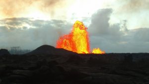
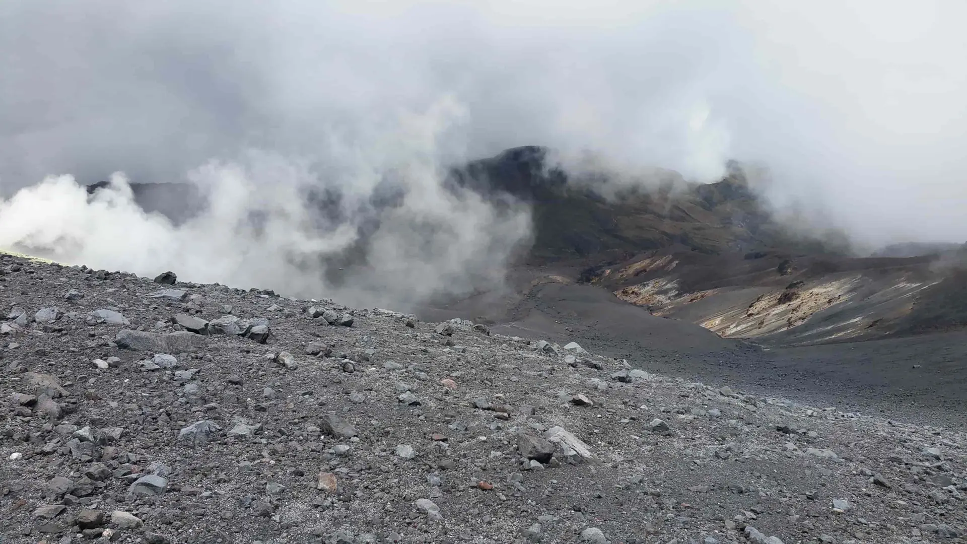
During the week, the effusive activity produced by the fissure opened on 8 February continued. The South-East Crater (CSE) showed Strombolian activity of varying intensity accompanied by volcanic ash emissions, while the Bocca Nuova (BN), Voragine (VOR) and North-East (CNE) craters were characterized by a variable rate of degassing activity.
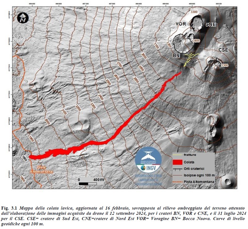
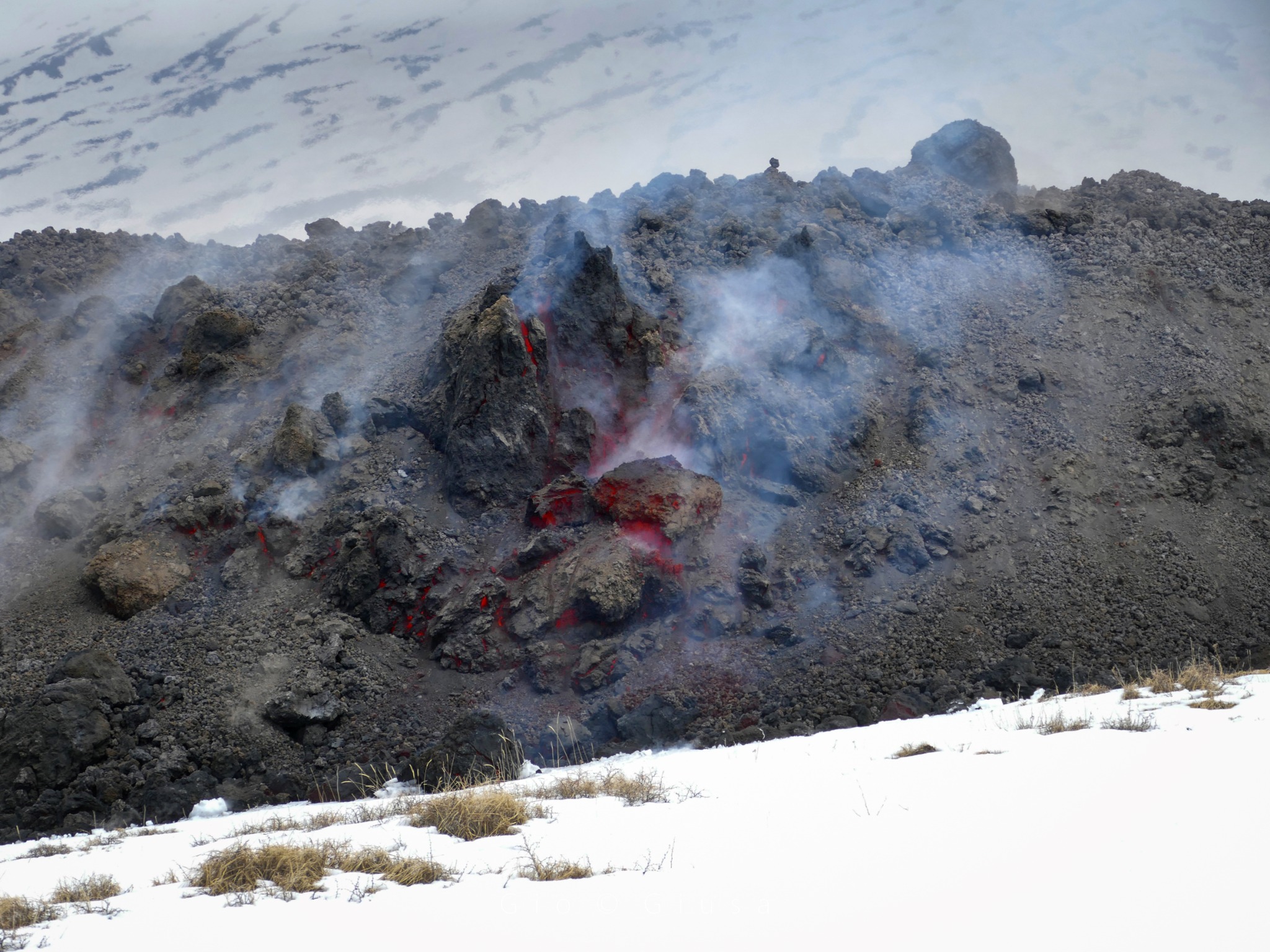
During the week, effusive activity continued, fueled by the eruptive fissure that opened at the base of the BN crater, at an altitude of about 3,050 meters above sea level, as already described in the bulletin Rep. N. 07/2025 ETNA. The lava flow, clearly visible from the southwest side, was fed throughout the week of 10 February. On 11 February, the most advanced front had reached an altitude of about 2,150 meters; on 13 February, the front was at about 1,960 m with a thickness of between 6 and 8 meters. During inspections carried out by INGV-OE staff on Sunday 16 February, it was found that the most advanced front had overtaken the slope of the pista altomontana. The lava flow map was developed by analyzing photogrammetric products obtained from two drone overflights on February 14 and 16, and from Skysat and Sentinel 2 satellite images. In the 48 hours between the two surveys, the lava flow covered 380 m. In addition, the flow is 4.2 km long and covered an area from the start of the eruption to February 16 equal to 0.3 × 10^6 m^2. The volume is 2.1 × 10^6 m^3 and the error in the volume calculation is 40%.
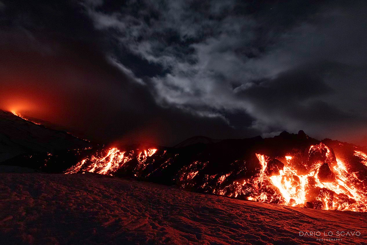
During the week, the interaction between the lava and the snowpack caused sudden phreatic explosions. In fact, the advancing lava flow can interact with pockets of snow that, once vaporized due to the high temperatures (up to several hundred degrees centigrade), can give rise to such explosions, projecting incandescent fragments of lava up to several hundred meters away. These explosions were reported by volcanological guides present in the field.
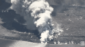
At the CSE, explosive activity produced by at least two active vents was also observed, as shown both by INGV-OE CCTV camera images and by field observations by INGV-OE staff on 12 February. During this study, low explosive activity was also detected from a vent opening between the CSE and the BN crater. The CSE was also characterized by slight volcanic ash emissions, which were rapidly dispersed by winds and deposited in the immediate vicinity of the volcano summit. However, on 12, 14 and 16 February, analysis of INGV-OE CCTV images, as well as field observations, highlighted an increase in volcanic ash emissions. In particular, although often hampered by the presence of cloud cover, the analysis of images from the INGV-OE surveillance cameras, suitably calibrated, allowed us to estimate that the eruptive column did not exceed 5500 meters above sea level. During inspections carried out by INGV-OE staff, fine ash was collected at Zafferana (12 February), along the Mareneve road (14 February) and in the Milia district near Ragalna (16 February). Finally, the other summit craters were characterized by variable rate degassing activity.
Source : INGV.
Photos : INGV , Dario Lo Scavo , Gio Giusa .
Italy , Stromboli :
WEEKLY BULLETIN, from February 10, 2025 to February 16, 2025. (issue date February 18, 2025)
SUMMARY OF ACTIVITY STATUS
In light of the monitoring data, it is highlighted:
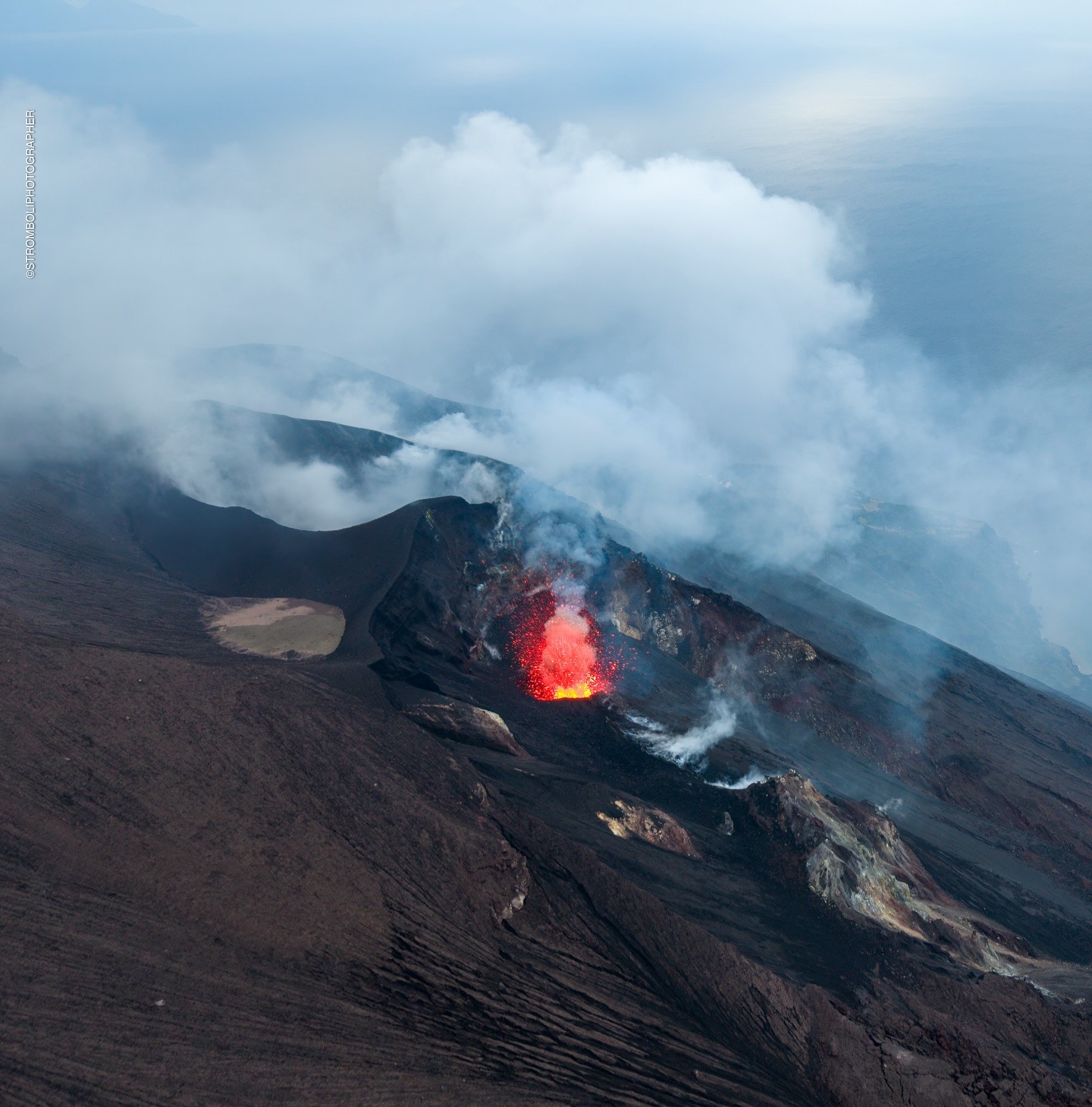
1) VOLCANOLOGICAL OBSERVATIONS: During this period, intense eruptive activity was observed with splashes coming from the North crater area and the production of a lava accumulation.
The total hourly frequency varied between average values (8-13 events/h). The intensity of the explosions was low and medium in the N and CS crater areas.
2) SEISMOLOGY: The monitored seismic parameters do not show significant variations.
3) GROUND DEFORMATIONS: The ground deformation monitoring networks did not show significant variations during the last week.
4) GEOCHEMISTRY: SO2 flux at medium level.
Soil CO2 flux from the Pizzo area (STR02): remains at very high values, decreasing.
CO2/SO2 ratio in the plume (Stromboli Plume Network) at high values
Helium isotope ratio (R/Ra) dissolved in the thermal aquifer: last updated on 31 January 2025 at high values.
Soil CO2 flux in the San Bartolo area at medium values.
Soil CO2 flux in the Scari area at medium values.
5) SATELLITE OBSERVATIONS: The thermal activity observed by satellite in the summit area was generally at low level.
VOLCANOLOGICAL OBSERVATIONS
During the observation period, the eruptive activity of Stromboli was characterized by the analysis of the images recorded by the INGV-OE surveillance cameras located at an altitude of 190 m (SCT-SCV) and at Punta dei Corvi (SPCT). The explosive activity was produced, mainly, by 4 (four) eruptive vents located in the North crater area and by 2 (two) vents located in the Centre-South area.
In the North (N) crater area, four active vents were observed that produced explosive activity of low intensity (less than 80 m in height) and sometimes of medium intensity (less than 150 m in height). In addition, at the mouth of sector N2, a splashing activity was observed that was intense at times during the day of 10 February. The emitted products consisted mainly of coarse materials (bombs and lapilli). The average explosion frequency varied between 8 and 13 events/h.
In the South-Central (CS) area, explosive activity was produced by at least two vents, the explosions were of low and medium intensity and consisted mainly of coarse materials (lapilli and bombs). The average explosion frequency varied between 1 and 2 events/h.
On 10 February, starting at 13:08 UTC, an intense spattering activity began from the mouth facing the Sciara del Fuoco in sector N2, which intensified in a few minutes.
producing an accumulation of lava fragments that extended below the emission mouth for a few tens of meters. Starting at 18:00 UTC, the accumulation appears to be cooling and poorly fed.
Source : INGV.
Photo : Stromboli stati d’animo / Sebastiano Cannavo.
Indonesia , Ibu :
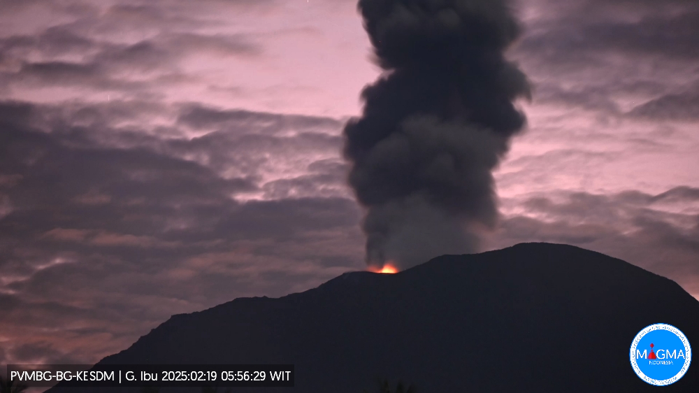
An eruption of Mount Ibu occurred on Wednesday, 19 February 2025, at 05:53 WIT with an observed ash column height of ± 800 m above the peak (± 2125 m above sea level). The ash column was observed to be white to grey in colour with a thick intensity, oriented towards the East. This eruption was recorded on a seismograph with a maximum amplitude of 28 mm and a duration of 59 seconds.
The volcano continues to erupt.
VOLCANO OBSERVATORY NOTICE FOR AVIATION – VONA
Issued : February 19 , 2025
Volcano : Ibu (268030)
Current Aviation Colour Code : ORANGE
Previous Aviation Colour Code : orange
Source : Ibu Volcano Observatory
Notice Number : 2025IBU355
Volcano Location : N 01 deg 29 min 17 sec E 127 deg 37 min 48 sec
Area : North Maluku, Indonesia
Summit Elevation : 4240 FT (1325 M)
Volcanic Activity Summary :
Eruption with volcanic ash cloud at 21h53 UTC (05h53 local).
Volcanic Cloud Height :
Best estimate of ash-cloud top is around 6800 FT (2125 M) above sea level or 2560 FT (800 M) above summit. May be higher than what can be observed clearly. Source of height data: ground observer.
Other Volcanic Cloud Information :
Ash cloud moving to southeast. Volcanic ash is observed to be gray. The intensity of volcanic ash is observed to be thick.
Remarks :
Eruption recorded on seismogram with maximum amplitude 28 mm and maximum duration 59 second.
Source et photo : Magma Indonésie .
Colombia , Puracé – Los Coconucos volcanic chain :
Popayan, February 17, 2025, 4:00 p.m. .
Following the monitoring of the activity in the Los Coconucos volcanic chain, the Colombian Geological Survey (SGC), an entity attached to the Ministry of Mines and Energy, reports that:
Since 2:51 p.m. today, a continuous seismic signal (tremor) has been recorded. Given the characteristics of the signal, it is possible that it is associated with an ash emission, which cannot be confirmed at this time due to the cloudy conditions at the top of the volcanic chain. As soon as we have more information, we will keep you informed.
In Yellow Alert status, the volcano may exhibit phenomena such as sporadic ash emissions (minor eruptions) whose scope and effects are limited and the dispersion of ash depends on the wind direction, presence of some incandescences, small explosions in the crater, low-energy thermal anomalies, noises, felt earthquakes, odors, precipitation of elemental sulfur near the crater and in hot springs and fumaroles, degassing in areas other than the crater, formation of fissures and appearance of minor lahars.
Based on the above, the SGC recommends closely monitoring the evolution through the extraordinary bulletins and other information published through our official channels, as well as the instructions of the local and departmental authorities and the National Disaster Risk Management Unit (UNGRD).
The status of volcanic activity remains on yellow alert: Active volcano with changes in the behavior of the base level of the monitored parameters and other manifestations.
Images captured by visible spectrum and infrared webcams showed degassing processes in the lateral fumarole of the Puracé volcano crater and in the system of fissures and cavities that extends between the Curiquinga and Piocollo volcanoes. Since yesterday, reports have been received from residents of the sector regarding changes in the color of the water and odors of sulfur compounds in the tributaries located towards the Puracé sector (Cocuy, San Francisco and Vinagre rivers) and Paletará (Río Blanco), these changes may be associated with the entrainment of ash deposited on the flanks of the Puracé, Piocollo and Curiquinga volcanoes during the emission of January 20, favored by the appearance of rain in the region.
Source : SGC
Photo : Angel on travel ( 2024)
Costa Rica , Rincon de la Vieja :
Latitude: 10.83°N;
Longitude: 85.34°W;
Elevation: 1916 m
Current Activity Level: Warning
This week, one eruption and four expirations were recorded. None of these events generated ash or mudflows. Background tremor remains of moderate amplitude with a frequency range of 1 to 6.5 Hz. Occasionally, background tremor fragments.
« Tornillo » type signals also persist. The dominant frequency of « tornillos » shows a slight increasing trend in recent weeks. Distal volcano-tectonic earthquakes are recorded (South flank of the volcano). Geodetic observations show stability at the base and summit.
During the last week, the average SO2 flux was 213 ± 81 t/d, higher than the previous week (126 ± 24 t/d). The OMI instruments on the SENTINEL satellite have not detected SO2 in the atmosphere since 26 December 2024.
Source : Ovsicori
Photo : Auteur inconnu.