February 14 , 2025.
Italy / Sicily , Etna :
VOLCANO OBSERVATORY NOTICE FOR AVIATION (VONA)
Issued: 20250213/0945Z
Volcano: Etna 211060
Current Color Code: ORANGE
Previous Color Code: red
Source: Etna Volcano Observatory
Notice Number: 2025/0008/01F01
Volcano Location: 3744N 01500E
Area: Italy
Summit Elevation: 3300 m
Volcanic Activity Summary:
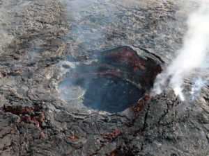
Explosive activity decreases. Low ash emission still ongoing.
Volcanic cloud height: N/A
Other volcanic cloud information:
VOLCANIC ASH IS CONFINED TO THE SUMMIT AREA
Remarks:
THE PHENOMENON IS OBSERVED BY INGV’S PERSONNEL ON THE FIELD AND BY VISIBLE AND THERMAL SURVEILLANCE CAMERAS
Next Notice:
A new VONA will be issued if conditions change significantly or color code changes.
Sources : INGV , Boris Behncke via FB.
Photo : Dario Lo Scavo .
Chile , Lascar :
Special Report on Volcanic Activity (REAV), Antofagasta Region, Láscar Volcano, February 12, 2025, 16:00 local time (Chilean continent)
The National Geology and Mining Service of Chile (Sernageomin) announces the following information obtained through the monitoring equipment of the National Volcanic Monitoring Network (RNVV), processed and analyzed at the Southern Andean Volcanological Observatory (OVDAS):
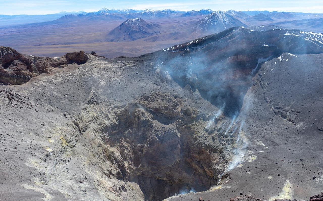
Since the first days of February 2025, changes in the monitoring parameters have been identified, showing an evolution in the dynamics of the volcanic system. The mentioned changes refer to an increase in degassing exceeding 2 km above the crater level, an increase in SO2 anomalies in the atmosphere reaching 752 tons on February 11 and an increase in thermal radiation inside the crater subsequently linked to the recording of a thermal anomaly according to the 1 MW VIIRS sensor (mirovaweb.it).
Volcanic seismicity does not yet show clear variations related to this phenomenon; However, some earthquakes have been recorded after the start of the aforementioned increase. On February 7, an LP-type earthquake was recorded associated with a low-energy fluid movement (4 cm2) with harmonic characteristics in its shape; On February 9, a volcano-tectonic earthquake of ML 2.2 located 1.2 km from the active crater and an LP evaluated with a Reduced Displacement DR of 10 cm2, being higher than the average of the last months (5 cm2). This seismicity could be related to the dynamic evolution of the surface system where a transient overpressure would cause its opening.
Due to an evident increase in the levels of volcanic activity detected, and considering the possibility of the appearance of minor eruptive pulses, the technical volcanic alert has been modified, considering a possible area of 1 km of impact around the active crater of the volcano.
The technical volcanic alert is modified to: YELLOW.
Observation:
A potential impact zone of 1 km from the center of the active crater is envisaged, without excluding that possible particles could exceed this zone.
Source : Sernageomin .
Photo : Vulcanopro. ( Archive).
Indonesia , Ibu :
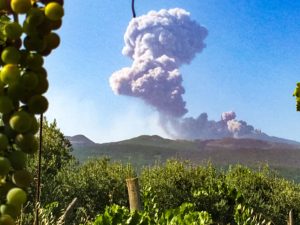
An eruption of Mount Ibu occurred on Thursday, 13 February 2025 at 11:32 WIT with an observed ash column height of ± 1500 m above the peak (± 2825 m above sea level). The ash column was observed to be grey in colour with a thick intensity, oriented towards the South-East. This eruption was recorded on a seismograph with a maximum amplitude of 28 mm and a duration of 149 seconds. The volcano continues to erupt.

VOLCANO OBSERVATORY NOTICE FOR AVIATION – VONA
Issued : February 13 , 2025
Volcano : Ibu (268030)
Current Aviation Colour Code : ORANGE
Previous Aviation Colour Code : orange
Source : Ibu Volcano Observatory
Notice Number : 2025IBU301
Volcano Location : N 01 deg 29 min 17 sec E 127 deg 37 min 48 sec
Area : North Maluku, Indonesia
Summit Elevation : 4240 FT (1325 M)
Volcanic Activity Summary :
Eruption with volcanic ash cloud at 02h32 UTC (11h32 local).
Volcanic Cloud Height :
Best estimate of ash-cloud top is around 9040 FT (2825 M) above sea level or 4800 FT (1500 M) above summit. May be higher than what can be observed clearly. Source of height data: ground observer.
Other Volcanic Cloud Information :
Ash cloud moving to southeast. Volcanic ash is observed to be gray. The intensity of volcanic ash is observed to be thick.
Remarks :
Eruption recorded on seismogram with maximum amplitude 28 mm and maximum duration 149 second.
Source et photo : Magma Indonésie.
Hawaii , Kilauea :
Thursday, February 13, 2025, 9:14 AM HST (Thursday, February 13, 2025, 19:14 UTC)
19°25’16 » N 155°17’13 » W,
Summit Elevation 4091 ft (1247 m)
Current Volcano Alert Level: WATCH
Current Aviation Color Code: ORANGE
Summit Observations:
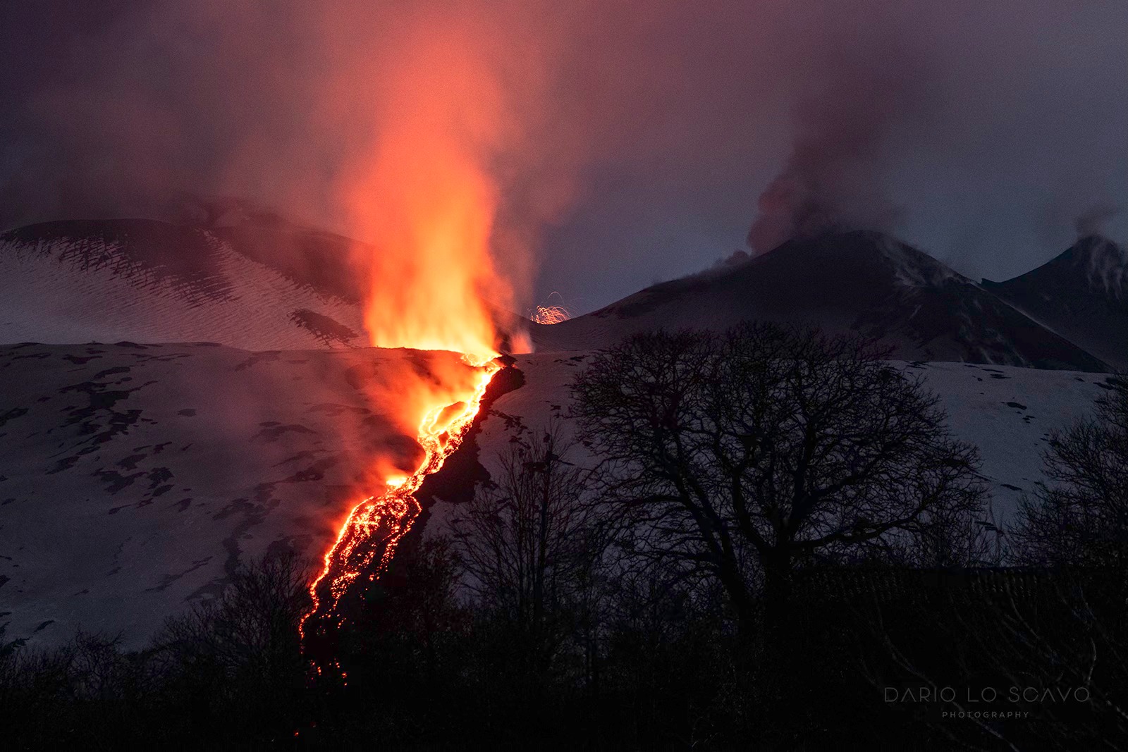
Episode 9 ended at 8:43 a.m. HST yesterday morning, February 12, after 22.5 hours of lava fountaining at the north and south vents in the western part of Halemaʻumaʻu at the summit of Kīlauea. Episode 9 lava flows covered approximately 50-60% of Halemaʻuʻmaʻu floor. Last night, several lava flows continued to slowly flow on the floor of Halemaʻumaʻu and other incandescent areas remained visible on the crater floor as recently erupted lava continues to cool. The north vent continues to degas and glow faintly at night, indicating magma remains at relatively shallow levels in the vent.

Over the course of ten minutes, USGS Hawaiian Volcano Observatory field crews observed the south vent activity cease until lava could no longer be seen or heard from the south vent. At 8:43 a.m. HST on February 12, 2025, episode 9 of the 2024-2025 Halema‘uma‘u eruption was over.
The Uēkahuna tiltmeter (UWD) switched from deflation to inflation at about the same time that episode 9 ended at 8:43 a.m. HST yesterday, February 12. UWD has recorded nearly 3 microradians of inflationary tilt since then. Seismic tremor remains elevated but decreased with the end of episode 9. No significant earthquakes were recorded in the summit region over the past 24 hours.
Wind conditions and the timing of episode 9 prevented accurate measurements of the sulfur dioxide (SO2) emission rate. SO2 emission rates during episode 9 are estimated to have been 10,000 t/d or higher based on emissions measured during earlier episodes. During eruptive pauses, SO2 emission rates are lower and typically around 1,000 t/d.
Rift Zone Observations:
Rates of seismicity and ground deformation remain very low in the East Rift Zone and Southwest Rift Zone with no significant earthquake activity in the past 24 hours. Sulfur dioxide (SO2) from the East Rift Zone remains below detection limit.
Source : HVO
Photo : USGS / K. Lynn.
Colombia , Galeras :
San Juan de Pasto, February 11, 2025, 5:45 p.m. .
Following the monitoring of the activity of the Galeras volcano, the Colombian Geological Survey (SGC), an entity attached to the Ministry of Mines and Energy, reports that:
Between February 4 and 10, 2025, volcanic activity remained at low levels, similar to those recorded in the previous period. Compared to the previous week, the main variations in the monitored parameters were:
• An increase in the frequency and released seismic energy was observed, with a predominance of seismicity associated with rock fracture processes within the volcano.
• Rock fracture earthquakes were located scattered throughout the volcanic region, at distances of up to 16 km, with depths of up to 15 km and a maximum magnitude of 1.3. A group of low-energy earthquakes located close to the volcanic cone, with depths less than 2 km from the summit (4,200 m a.s.l.), stands out as a source that has been recorded recurrently in recent months.
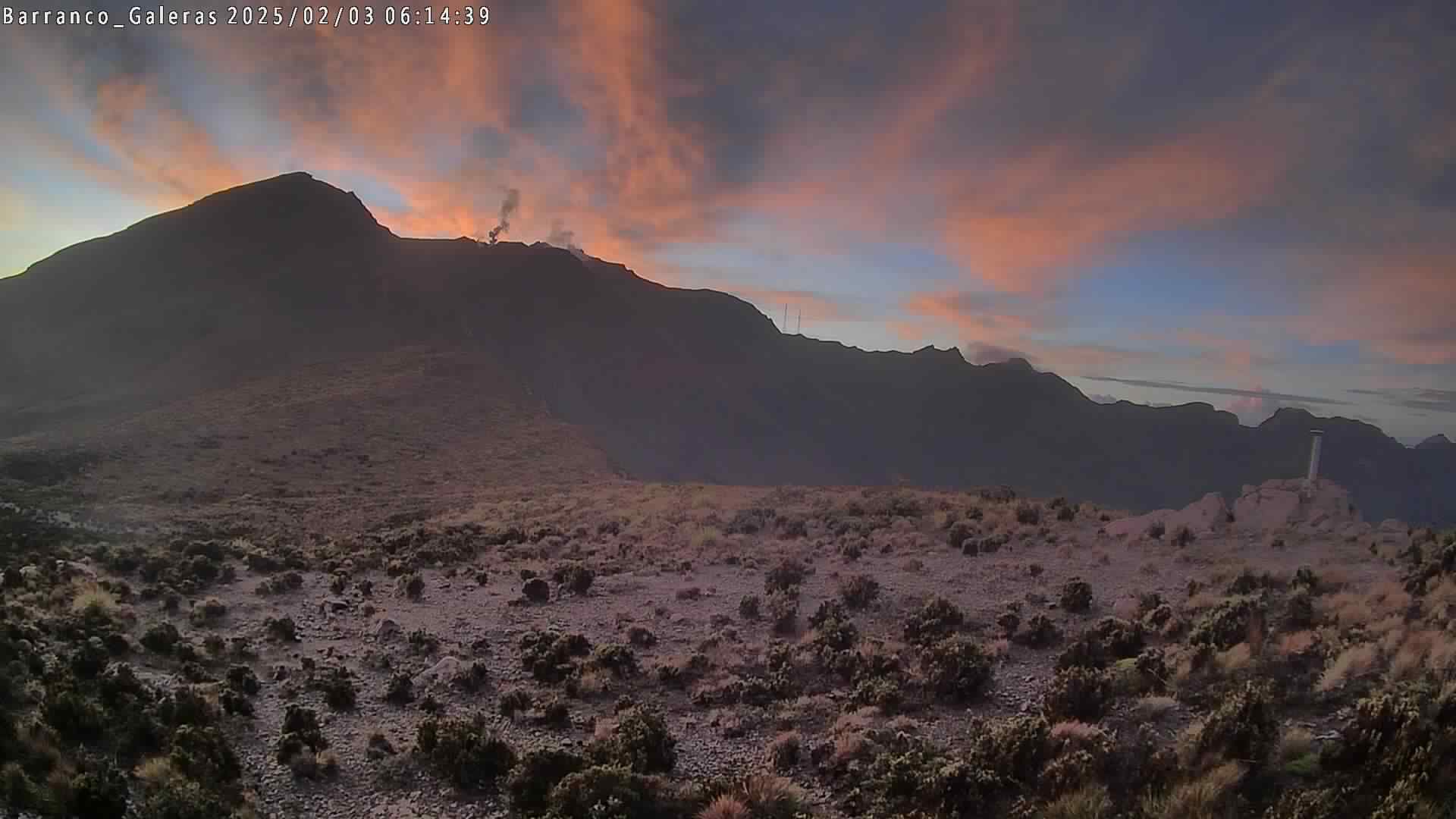
• Low-altitude white gas emissions, with variable dispersion depending on the wind direction, were observed, coming from the main crater and the fumarole fields of Las Chavas, to the west, and El Paisita, to the north of the active cone.
• The other parameters of the volcanic monitoring showed stability.
Based on the above, the SGC recommends closely monitoring the evolution through the weekly bulletins and other information published through our official channels, as well as the instructions of the local and departmental authorities and the National Disaster Risk Management Unit (UNGRD).
The volcanic activity remains in yellow alert status: active volcano with changes in the behavior of the base level of the monitored parameters and other manifestations.
Source et photo : SGC