February 13 , 2025.
Italy / Sicily , Etna :
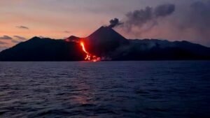
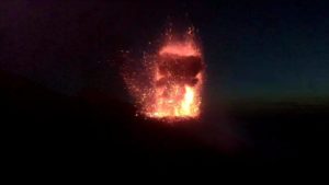
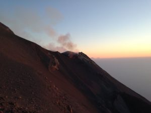
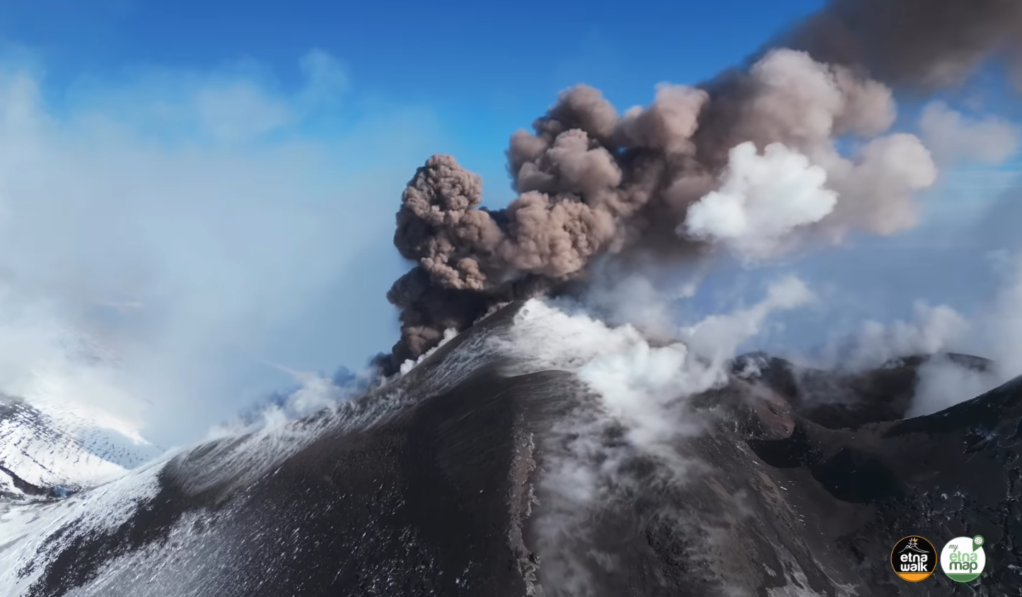
Sezione di Catania – Osservatorio Etneo (INGV) reported that a new eruption began at Etna on 6 February. Explosive Strombolian activity began at a vent located in the W part of SE Crater. On 8 February a fissure opened at the base of Bocca Nuova Crater at an elevation of around 3,050 m and produced a lava flow that traveled SW towards Mt. Frumento Supino. The first observations through the webcam occurred at 18h35, though weather conditions obscured views before that time so there was a possibility that effusion started a few hours earlier. Strombolian activity persisted at SE Crater. The Aviation Color Code was raised to Yellow (the second lowest level on a four-color scale) at 20h04 and then to Orange at 20h19. By 11 February the lava flow was about 2.6 km long and had reached an elevation of 2,600 m. The Aviation Color Code was raised to Red, the highest level, at 10h30 on 12 February because of strong explosive activity at the summit craters.
VOLCANO OBSERVATORY NOTICE FOR AVIATION (VONA)
Issued: february 12 , 2025
Volcano: Etna 211060
Current Color Code: RED
Previous Color Code: orange
Source: Etna Volcano Observatory
Notice Number: 2025/0007/01E01
Volcano Location: 3744N 01500E
Area: Italy
Summit Elevation: 3300 m
Volcanic Activity Summary:
STRONG EXPLOSIVE ACTIVITY IS OBSERVED AT SUMMIT CRATERS
Volcanic cloud height:
VOLCANIC CLOUD HEIGHT IS NOT ESTIMABLE
Other volcanic cloud information: N/A
Remarks:
THE PHENOMENON IS OBSERVED BY OBSERVED BY INGV’S PERSONNEL ON THE FIELD AND BY VISIBLE AND THERMAL SURVEILLANCE CAMERAS
Next Notice:
A new VONA will be issued if conditions change significantly
or color code changes.
Source : GVP , INGV.
Photo : Giuseppe Distfano / Etna Walk , Capture d’écran 12 / 02 / 2025 .
Hawaii , Kilauea :
Wednesday, February 12, 2025, 9:19 AM HST (Wednesday, February 12, 2025, 19:19 UTC)
19°25’16 » N 155°17’13 » W,
Summit Elevation 4091 ft (1247 m)
Current Volcano Alert Level: WATCH
Current Aviation Color Code: ORANGE
Activity Summary:
Kīlauea stopped erupting this morning in Hawaiʻi Volcanoes National Park. Episode 9 of the ongoing summit eruption paused at 8:43 a.m. HST, February 12.
The was the ninth episode of Kīlauea’s ongoing eruption in Halemaʻumaʻu crater within Kaluapele (the summit caldera) that began on December 23, 2024. Fountain-fed lava flows from the north and south vents erupted onto the crater floor for over 22 hours. There have been 9 episodes of lava fountaining separated by pauses in activity. All recent eruptive activity has occurred in Hawaiʻi Volcanoes National Park. No significant changes have been noted along Kīlauea’s East Rift Zone or Southwest Rift Zone.

The Kīlauea Halema‘uma‘u eruption resumed with the start of episode 9 the morning of February 11, 2025. Both the north and south vent were active the evening of February 11, with the north vent lava fountain reaching heights of 50-60 meters (160-200 feet) and a max height of 75 meters (250 feet) at 7:40 p.m. HST. The south vent ranges between 25-30 meters (80-100 feet). This picture is taken from the west crater rim looking southeast.
Ongoing hazards include volcanic gas emissions and windblown volcanic glass (Pele’s Hair) that may impact Hawaiʻi Volcanoes National Park and nearby communities.
Summit Observations:
Episode 9 ended at 8:43 a.m. HST this morning, February 12, after 22 and a half hours of lava fountaining.
Fountains began erupting from the north vent at 10:16 a.m. HST yesterday, February 11, and slow effusion of lava began from the south vent shortly afterward, at around 10:50 a.m. HST. Vigorous, sustained fountains from the north vent reached heights of up to 330 feet (100 meters) during the initial hours of episode 9 and were averaging heights of up to 160-200 feet (50-60 meters) last night, while bifurcated south vent fountains were lower, reaching 80-100 feet (25-30 meters) high last night, February 11. This morning, February 12, effusion rates were decreased compared to yesterday. Fountains observed before 8:30 a.m. HST this morning were lower than yesterday and variable in height, reaching 100-150 feet (30-50 meters). Fountains continued to slowly drop until the vents started shutting down around 8:30 a.m. HST. Lava fountaining stopped from the north vent at 8:30 a.m. HST followed by large decrease in vigor of fountains from the south vent a few minutes later. A small amount of lava continued to erupt from the south vent until at 8:43 a.m. HST, when episode 9 ended.

New lava flows erupted during episode 9 traveled approximately half a mile (about a kilometer) across the floor of Halemaʻumaʻu and covered approximately 50-60% of Halemaʻuʻmaʻu floor.
The Uēkahuna tiltmeter (UWD) switched from inflation to deflation, and seismic tremor increased, at about the same time lava flows began erupting onto the crater floor yesterday morning, February 11, at 10:16 a.m. HST. UWD recorded nearly 13 microradians of deflationary tilt during the episode 9 eruption but switched to inflation as the vents shut down around 8:30 a.m. HST. Seismic tremor remains elevated but decreased with the end of episode 9. No significant earthquakes were recorded in the summit region over the past 24 hours.
Wind conditions and the timing of episode 9 prevented accurate measurements of the sulfur dioxide (SO2) emission rate. SO2 emission rates during episode 9 are estimated to have been 10,000 t/d or higher based on emissions measured during earlier episodes. During eruptive pauses, SO2 emission rates are lower and typically around 1,000 t/d.
Source : HVO.
Photos : USGS / H Winslow. Epic Lava / 11/02/2025.
Philippines , Kanlaon :
The Philippine Institute of Volcanology and Seismology (PHIVOLCS) reported continuing eruptive activity at Kanlaon during 4-11 February. The seismic network recorded 7-23 daily volcanic earthquakes, though during 5-6 February there was a total of 35 events. Average daily sulfur dioxide emissions ranged from 1,611 to 4,186 tonnes per day (t/d); emissions since 3 June 2024 averaged 4,484 t/d. Gas-and-steam emissions rose as high as 100 m above the summit and drifted W, WSW, and SW; plumes occasionally contained ash on 8 February.
A minor explosive eruption began at 15h11 on 6 February and lasted for two minutes based on seismic and infrasound data. An ash plume rose 600 m above the summit and drifted SW, causing minor ashfall in Mercedes and San Luis in the Sag-ang barangay (neighborhood) to the SW. The plume was partly obscured by rainy weather. The explosion was detected by instruments 5 km E and produced a booming sound reported in the barangays of Yubo (WSW) and Sag-ang. A sulfur odor was noted in several barangays in La Castellana to the S. Lahars descended the Buhangin River which flows through La Castellana and Moises Padilla.
The National Disaster Risk Reduction and Management Council (NDRRMC) report issued at 08h00 on 8 February stated that 9,835 people (3,106 families) were spread across 23 evacuation centers and another 8,383 people (2,651 families) were staying elsewhere. The Alert Level remained at 3 (on a scale of 0-5); the public was warned to stay 6 km away from the summit and pilots were warned not to fly close to the volcano.
Sources: Philippine Institute of Volcanology and Seismology (PHIVOLCS), The National Disaster Risk Reduction and Management Council (NDRRMC) , GVP.
Photo : Norbert Gallosa , 18/10/224
Indonesia , Lewotobi Laki-Laki :
Lewotobi Laki-laki activity level increased from level III (SIAGA) to level IV (AWAS) on 13 February at 03:00 WITA
Mount (G.) Lewotobi Laki-laki is one of the twin volcanoes located in the southeastern part of Flores Island, East Nusa Tenggara Province. This mountain has a height of 1,584 meters above sea level and is an active stratovolcano.
Visual and seismic observations of Mount Lewotobi Laki-laki from 3 January to 13 February at 00:00 WITA are as follows:
An eruption occurred at a height of 500 to 800 meters from the summit, the ash column from the eruption was white to gray.
Seismicity showed:
43 eruption earthquakes
987 emission earthquakes,
388 harmonic tremors,
59 low-frequency earthquakes,
17 shallow volcanic earthquakes,
267 deep volcanic earthquakes,
57 local tectonic earth tremors,
247 distant tectonic earthquakes,
8 flood earthquakes,
3 Continuous Tremor type earthquake with an amplitude of 4 to 7.4 mm, dominant value of 4.4 mm.
Visual observations during the period from January 3 to February 13, 2025 at 00:00 WITA, showed that the volcanic activity of Lewotobi Laki-laki increased, the average height of the eruption column was 500 to 800 meters and was no longer observed often due to fog. There is still a faint glow around the summit indicating that there is lava being pushed towards the surface, so at night a red glow can be observed in the peak area.
During this period, emissions increased, indicating that internal pressure was beginning to increase.

The smoke emitted in the area around the peak on the northwest side, which forms like cracks, tends to be thin-thick . The presence of crater smoke (solfatara) is due to the existence of an alteration zone (weak zone), so that the solfatara smoke is visible at the outlet of the area. This area has the potential for a « directed explosion » (direct eruption in one direction) that can occur in a northwest/northeast direction from Mount Lewotobi Laki-laki.
The eruption earthquakes of this period are still fluctuating as in the previous period, indicating that there is still a supply of magma .
The increasing number of harmonic earthquakes indicates that the movement of fluids or the release of gas from the magma filling the fractures tends to increase.
The increase in the number of low-frequency earthquakes indicates the activity of magmatic fluid flow from the conduit to the surface, propagating upward to the surface.
Shallow volcanic earthquakes were recorded with an increase in their number compared to the previous period, which indicates that the intensity of magmatic activity in the magma chamber of Lewotobi Laki-laki volcano is increasing.
The number of local tectonic earthquakes remains stable as in the previous period.
During this period, flood vibrations decreased, as well as the decreasing intensity of rainfall around Lewotobi Laki-laki Mountain. The materials released by the eruption and deposited around Lewotobi Laki-laki Mountain have the potential to transform into lahars in case of heavy rainfall.
There was an increase in volcanic earthquakes on February 11, 2025 from 22:00 WITA to February 13, 2025 at 00:00 WITA and it is still ongoing until this report is written.
The results of visual and seismic monitoring show an increasing trend in volcanic activity on Lewotobi Laki-laki and a sudden increase in volcanic earthquakes. It is possible that an eruption will occur in the future.
Based on the results of a comprehensive analysis and evaluation of visual and instrumental monitoring, it shows that the visual and seismic activity on Mount Lewotobi Laki-laki has increased, so that the activity level of Mount Lewotobi Laki-laki has increased from level III (SIAGA) to level IV (AWAS) at 03:00 WITA.
Source : PVMBG
Photo : Magma Indonésie ( 9/2024)
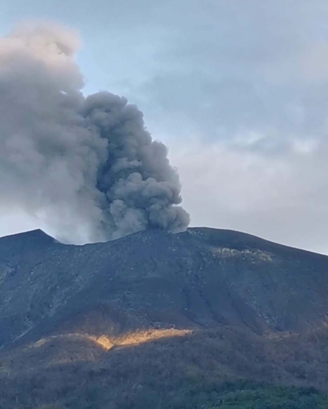
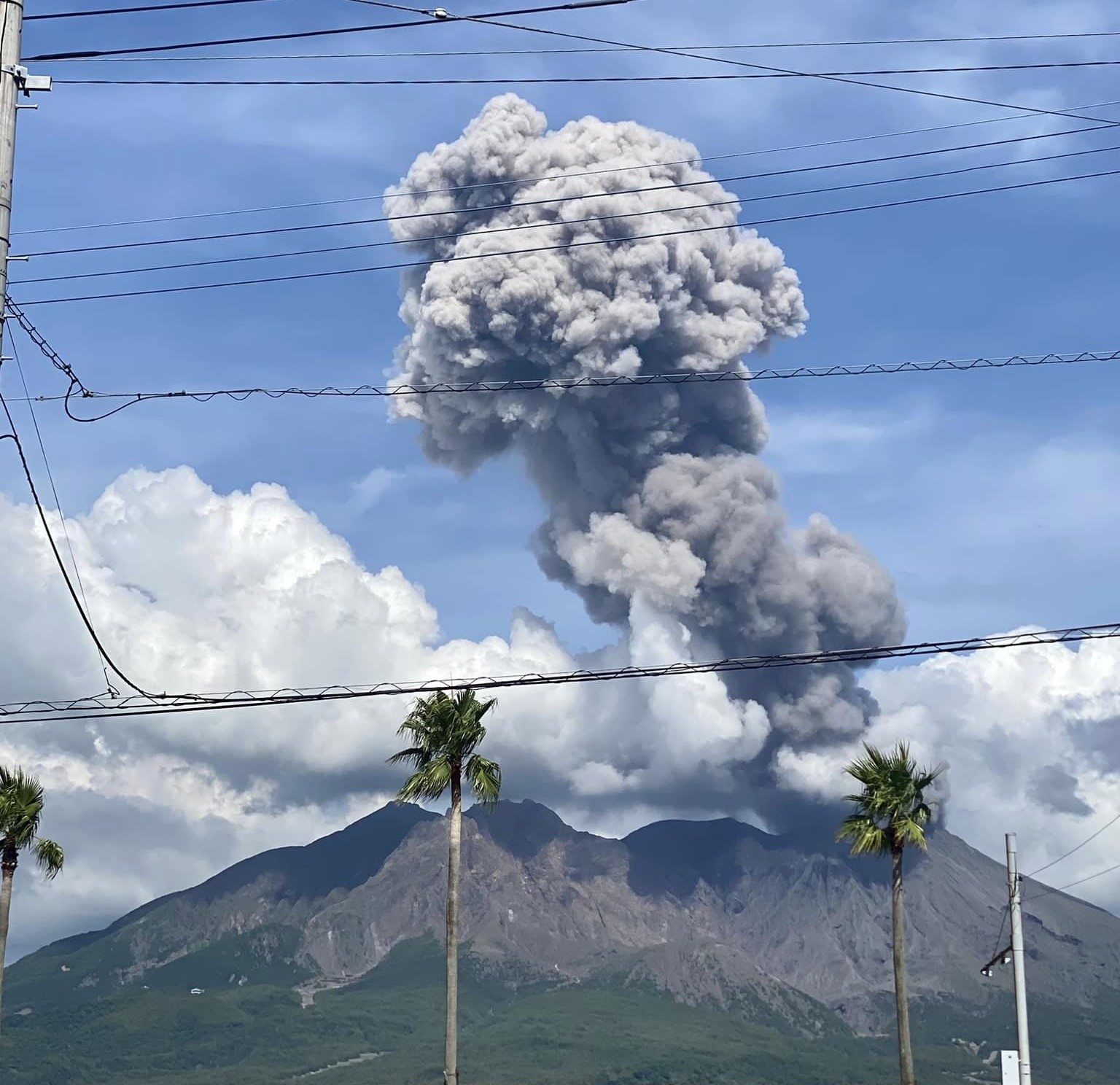
Japan , Sakurajima :
The Japan Meteorological Agency (JMA) reported ongoing eruptive activity at Minamidake Crater (Aira Caldera’s Sakurajima volcano) during 3-10 February. Nightly crater incandescence was visible in webcam images. An explosion at 17h19 on 4 February was recorded by the seismic network, though details of any emissions were unknown. Explosions at 07h02 on 6 February, at 07h02, 14h12, and 19h46 on 8 February, and at 05h56, 07h37, and 20h03 on 9 February generated ash plumes that rose 0.4-2 km above the crater rim and drifted SE. A few of the emissions rose into the weather clouds. Each of the explosions, except the one at 14h12 on 8 February, ejected large blocks 400-1,200 m from the crater rim. The Alert Level remained at 3 (on a 5-level scale), and the public was warned to stay 1 km away from both craters.
The Aira caldera in the northern half of Kagoshima Bay contains the post-caldera Sakurajima volcano, one of Japan’s most active. Eruption of the voluminous Ito pyroclastic flow accompanied formation of the 17 x 23 km caldera about 22,000 years ago. The smaller Wakamiko caldera was formed during the early Holocene in the NE corner of the caldera, along with several post-caldera cones. The construction of Sakurajima began about 13,000 years ago on the southern rim and built an island that was joined to the Osumi Peninsula during the major explosive and effusive eruption of 1914. Activity at the Kitadake summit cone ended about 4,850 years ago, after which eruptions took place at Minamidake. Frequent eruptions since the 8th century have deposited ash on the city of Kagoshima, located across Kagoshima Bay only 8 km from the summit. The largest recorded eruption took place during 1471-76.
Source: Japan Meteorological Agency (JMA) , GVP .
Photo : Kumiko Nagai (08/2024)