October 21 , 2024.
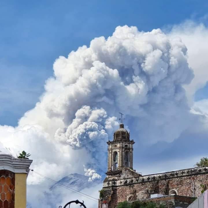
Mexico , Popocatepetl :
October 20, 11:00 (October 20, 17:00 GMT)
Activity in the last 24 hours
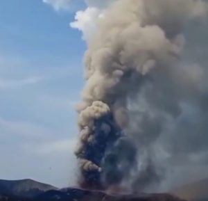
42 exhalations were detected, accompanied by water vapor, volcanic gases, and ash. In addition, 763 minutes of high-frequency tremor segments of low to medium amplitude were counted, for a total of 12.72 hours. The most significant tremor episode began at 11:47 and was accompanied by the emission of volcanic gases, ash, and some incandescent fragments a short distance from the crater. The plume reached a maximum height of 2 km above the crater.
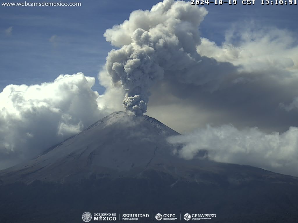
The National Communications Center (Cenacom) reported ash falls in the municipalities of Ozumba, Tlalmanalco and Ecatzingo, in the State of Mexico; and in the municipalities of Tlalnepantla, Tlayacapan and Totolapan in the State of Morelos.
A volcano-tectonic earthquake was also recorded today at 06:30, with a calculated magnitude of 1.8.
During the morning and at the time of this report, a continuous emission of water vapor and volcanic gases was observed, with dispersion towards the West-Southwest (WSO).
The Popocatépetl volcanic alert fire is in yellow phase 2.
The scenarios anticipated for this phase are:
A few small to moderate explosions
Occurrence of tremors of varying amplitude
Light to moderate ash rains in the surrounding towns and in some more distant towns
Ejection of incandescent fragments within the 12-kilometer exclusion radius
The occurrence of lahars can be expected to descend into the ravines, due to the accumulation of ash on the slopes and their interaction with the rains expected in the coming weeks.
Possibility of pyroclastic flows not reaching the populations
Source : Cenapred.
Photo : Cenapred , Rocio Galan.
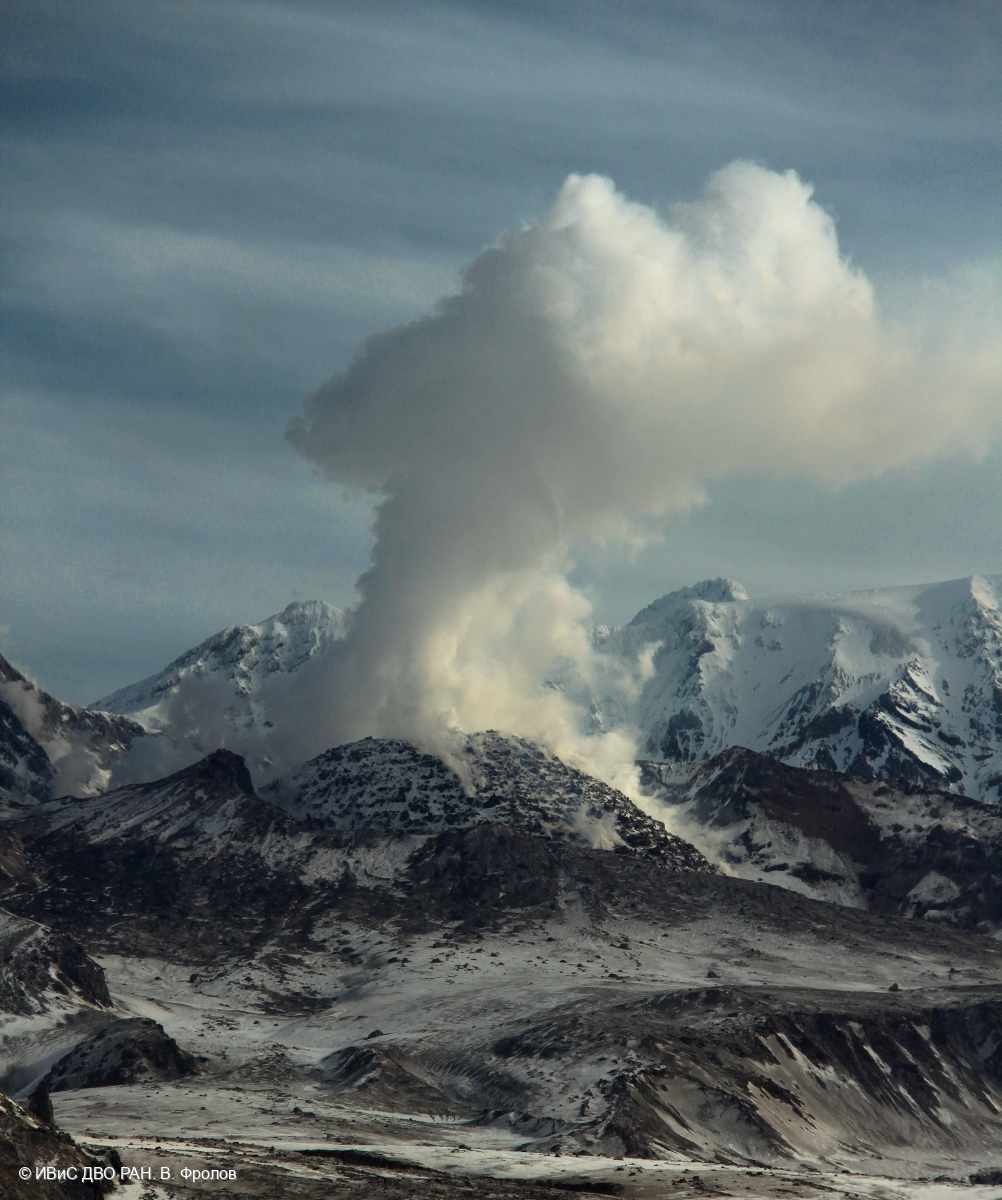
Kamchatka , Sheveluch :
VOLCANO OBSERVATORY NOTICE FOR AVIATION (VONA)
Issued: October 20 , 2024
Volcano: Sheveluch (CAVW #300270)
Current aviation colour code: ORANGE
Previous aviation colour code: orange
Source: KVERT
Notice Number: 2024-87
Volcano Location: N 56 deg 38 min E 161 deg 18 min
Area: Kamchatka, Russia
Summit Elevation: 3283 m (10768.24 ft), the dome elevation ~2500 m (8200 ft)
Volcanic Activity Summary:
Satellite data by KVERT shows a strong wind lifts ash from the southern slopes of Sheveluch volcano, and a plume of resuspended ash is extending about 380 km to the east-northeast of the volcano.
An extrusive-effusive eruption of the Sheveluch volcano continues. The danger of ash explosions up to 10 km (32,800 ft) a.s.l. remains. Ongoing activity could affect international and low-flying aircraft.
Volcanic cloud height:
3000 m (9840 ft) AMSL Time and method of ash plume/cloud height determination: 20241020/2120Z – Himawari-9 14m15
Other volcanic cloud information:
Distance of ash plume/cloud of the volcano: 380 km (236 mi)
Direction of drift of ash plume/cloud of the volcano: E / azimuth 82 deg
Time and method of ash plume/cloud determination: 20241020/2120Z – Himawari-9 14m15
Source : KVERT
Photo : V. Frolov. IVS FEB RAS ( 04/2024)
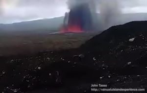
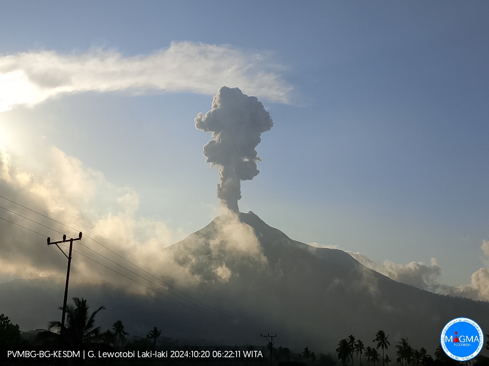
Indonesia , Lewotobi Laki-laki :
An eruption of Lewotobi Laki-laki occurred on Sunday, 20 October 2024 at 21:44 UTC (05:44 local time), with the height of the ash column observed at ±1000 m above the summit (±2584 m above sea level). The ash column was observed to be gray in color with a thick intensity, oriented towards the northwest. This eruption was recorded on a seismograph with a maximum amplitude of 10.5 mm and a maximum duration of 108 seconds.
VOLCANO OBSERVATORY NOTICE FOR AVIATION – VONA
Issued : October 20 , 2024
Volcano : Lewotobi Laki-laki (264180)
Current Aviation Colour Code : ORANGE
Previous Aviation Colour Code : orange
Source : Lewotobi Laki-laki Volcano Observatory
Notice Number : 2024LWK657
Volcano Location : S 08 deg 32 min 20 sec E 122 deg 46 min 06 sec
Area : East Nusa Tenggara, Indonesia
Summit Elevation : 5069 FT (1584 M)
Volcanic Activity Summary :
Eruption with volcanic ash cloud at 21h44 UTC (05h44 local).
Volcanic Cloud Height :
Best estimate of ash-cloud top is around 8269 FT (2584 M) above sea level or 3200 FT (1000 M) above summit. May be higher than what can be observed clearly. Source of height data: ground observer.
Other Volcanic Cloud Information :
Ash cloud moving from west to northwest. Volcanic ash is observed to be gray. The intensity of volcanic ash is observed to be thick.
Remarks :
Eruption recorded on seismogram with maximum amplitude 10.5 mm and maximum duration 108 second.
Source et photo : Magma Indonésie .
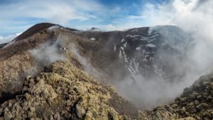
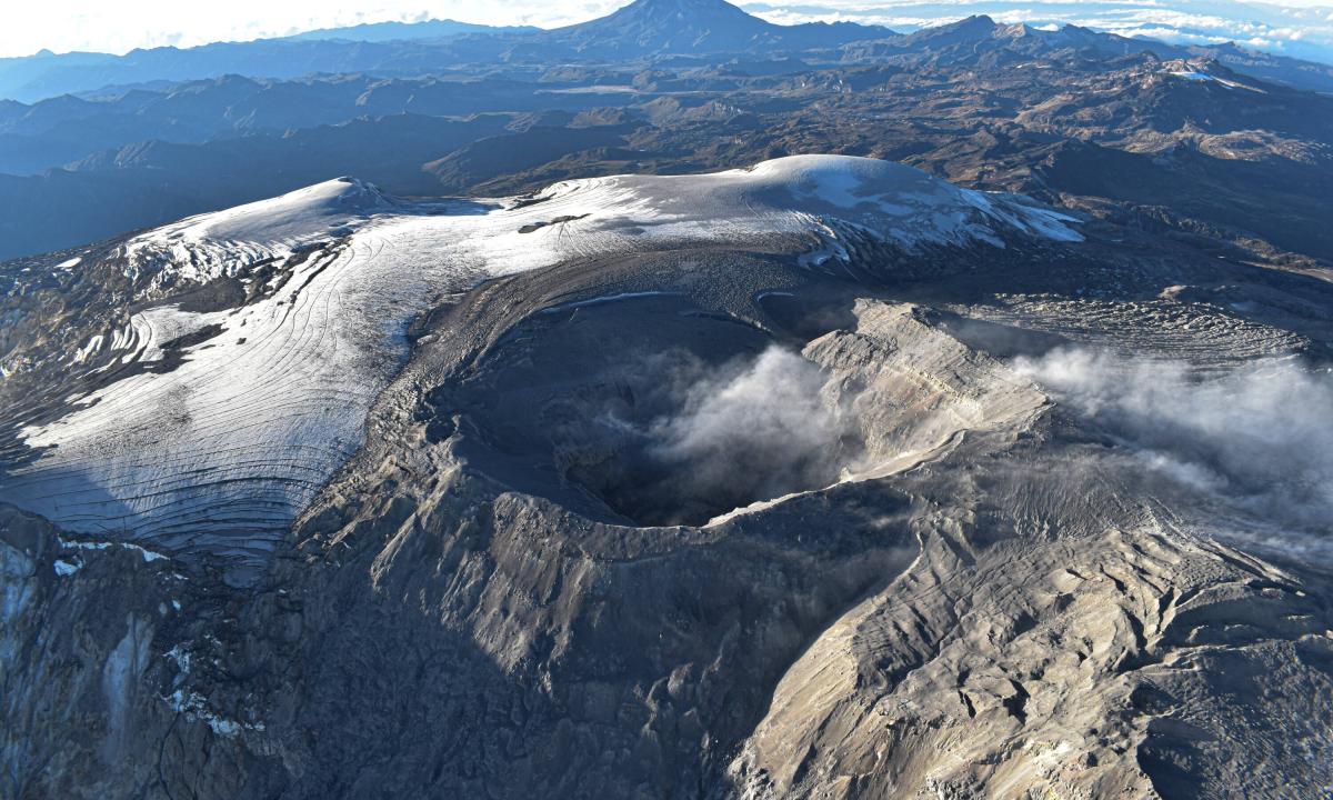
Colombia , Nevado del Ruiz :
Manizales, October 15, 2024, 7:30 p.m.
From the monitoring of the activity of the Nevado del Ruiz volcano, the Colombian Geological Survey (SGC), an entity attached to the Ministry of Mines and Energy, reports that:
During the week of October 8 to 14, 2024, the volcano continued with unstable behavior. Compared to the previous week, the main variations in the monitored parameters were:
– Seismicity related to the activity of fluids inside volcanic conduits showed an increase in the number of earthquakes recorded and the seismic energy released by seismic signals related to pulsatile ash emissions, as well as a decrease in long-period signals. The energy levels of the signals ranged from low to moderate (to sometimes high) for signals associated with pulsatile ash emissions and from low to very low for long-period events. Thanks to the cameras used to monitor the volcano and the reports received from the officials of the Los Nevados National Natural Park (PNNN), the personnel of the Colombian Geological Service on a field mission and the inhabitants of the area of influence, it was possible to confirm some ash emissions. Thanks to the FLIR (thermographic) cameras, several changes in the temperature of the emitted material were detected, highlighting the one recorded with the ash emission on October 11 at 02:03, to be the highest value observed so far this year. This change was also associated with a seismic signal with a high energy level, a value that had not been recorded since July 2024.
– Seismic activity associated with rock fracturing within the volcanic edifice increased in the number of recorded earthquakes and in the seismic energy released. The earthquakes were located mainly in the Arenas crater, on the northeastern flank and scattered on the other flanks, at distances generally less than 6 km from the crater. The depths of the events varied between less than 1 km and 7 km from the summit of the volcano. The strongest magnitude of the week was 1.4, corresponding to the earthquake recorded on October 12 at 08:33, located 1 km east-northeast of the Arenas crater, at a depth of 4 km, which occurred during a slight increase in seismicity. On 9 and 14 October, seismicity was recorded related to the activity of the lava dome (protuberance or mound) located at the bottom of the crater with low energy levels.
– The emission of water vapor and gas into the atmosphere from the Arenas crater continued. Sulfur dioxide (SO2) degassing rates were variable and similar to those of the previous week.
– The maximum height of the vertical gas column was 700 m (measured above the volcanic summit) on 13 October, and in dispersion it reached 1500 m on 11 October, associated with the ash emission at 02:03 mentioned above. The direction of dispersion of the column showed a marked trend towards the northwest of the volcano. This preferential direction and the high wind speeds caused ash falls in the sectors of Bruma and Valle de las Tumbas (in the PNNN area) and in the municipalities of Manizales and Villamaría (Caldas department), located in the indicated directions. – By monitoring the thermal anomalies at the bottom of the Arenas crater, from satellite monitoring platforms, some reports of low energy level anomalies were obtained.
Source et photo : SGC
Guatemala , Fuego :
Altitude: 3,763 meters
Atmospheric conditions: Clear weather.
Wind: Northeast, East, Southeast.
Precipitation: 37.6 mm.
Activity:
Due to the atmospheric conditions, the wind is variable in the volcanic area, the crater has been observed with weak, moderate and some strong explosions, in ranges of 6 to 9 per hour, accompanied by ash columns between 4,500 and 4,800 meters above sea level (14,763 – 15,748 feet) dispersing towards the Northwest, West, Southwest, for about 30 km. Ash falls in the villages of Panimaché, Morelia, Santa Sofía, Yucales, El Porvenir, Yepocápa, La Soledad, with probability of propagation to Parramos and Chimaltenango and others in this area. Some explosions generate airplane turbine and train locomotive sounds for up to 2 minutes.
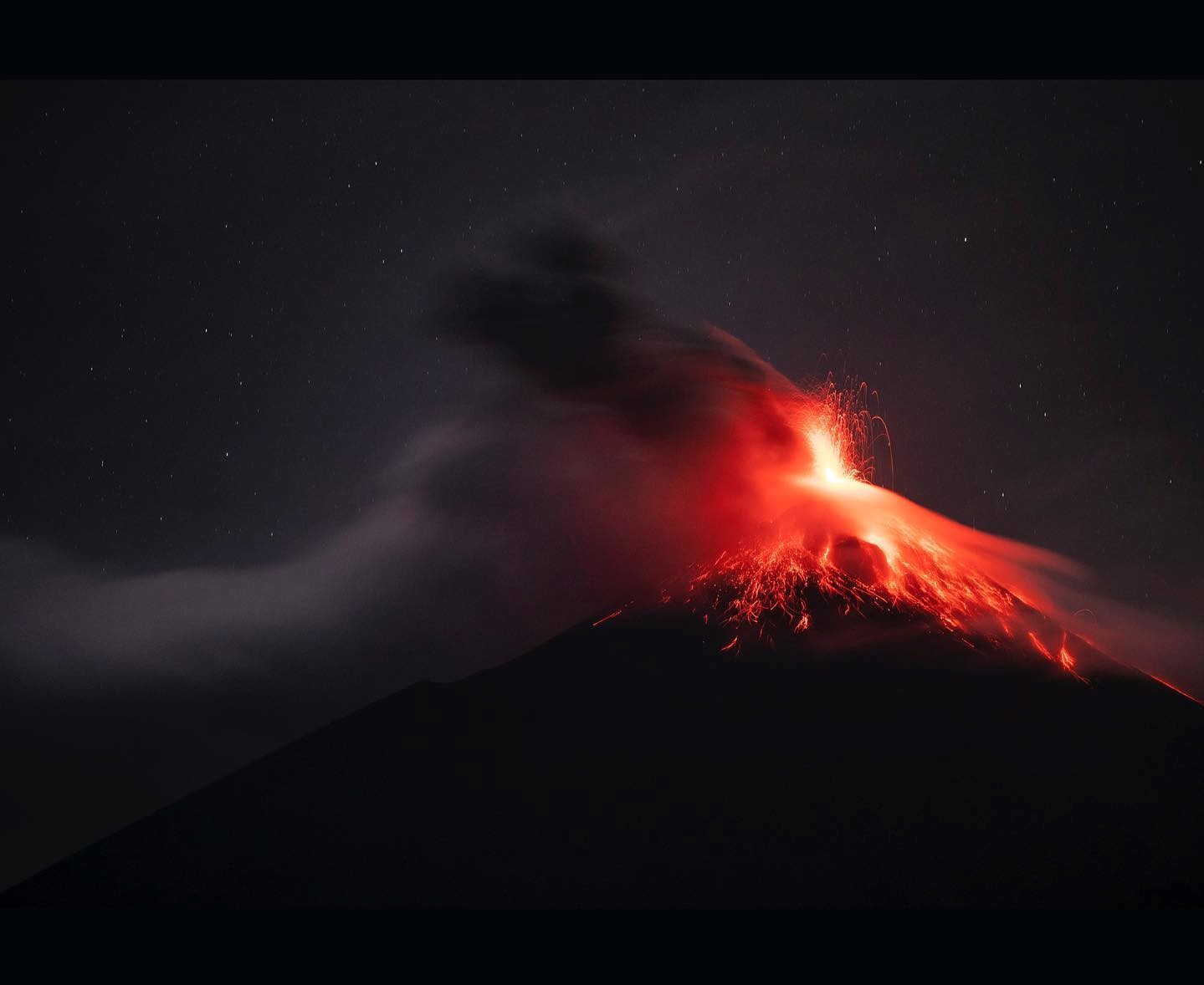
Strong explosions can eject ballistic elements on the plateau, making it dangerous to climb and/or stay in this place. Take into account that in the afternoon and at night, moderate and heavy rains will continue in the volcanic area, so lahars can be generated by any of the ravines around the volcano. It is recommended to take precautions when passing vehicles through the rivers and ravines around the volcano.
Source : Insivumeh.
Photo : Diego Rizzo ( 2022).