September 20 , 2024 .
Hawaii , Kilauea :
Thursday, September 19, 2024, 10:24 AM HST (Thursday, September 19, 2024, 20:24 UTC)
19°25’16 » N 155°17’13 » W,
Summit Elevation 4091 ft (1247 m)
Current Volcano Alert Level: WATCH
Current Aviation Color Code: ORANGE
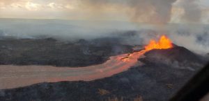
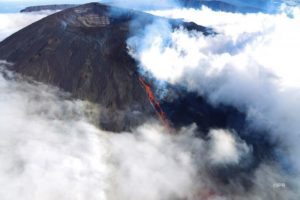
The 150-m-long (nearly 500 feet) fissure erupting west of Nāpau Crater within Hawaʻi Volcanoes National Park began erupting yesterday, September 18, around 3:15 p.m. It’s part of an eruptive sequence that began in this area the night of September 15, 2024. Overnight, this fissure fed a lava flow that cascaded into the crater via a channel more than 50 meters (about 164 feet) wide.
Activity Summary:
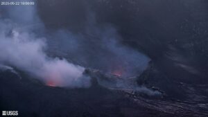
Kīlauea volcano continues to erupt in Hawai’i Volcanoes National Park from the new fissure vent that opened just west of Nāpau Crater yesterday, September 18, afternoon around 3:15 PM HST. This is the fourth vent system of this eruption and it began rapidly creating lava cascades or lava falls that poured over the western cliffs of Nāpau Crater. The activity continued over night and the lava falls were visible on the S2 webcam this morning. The eruption is occurring within a closed and remote area of Hawaiʻi Volcanoes National Park. There is no immediate threat to life or infrastructure. Residents of nearby subdivisions may experience volcanic gas emissions related to this activity which may increase and decrease over the coming hours and days. The Volcano Alert Level/Aviation Color Code remains at WATCH/ORANGE. No changes have been detected in the lower East Rift Zone or Southwest Rift Zone.
Summit Observations:
Only 1 small, shallow earthquake was detected beneath the Kīlauea summit region over the past 24 hours. The summit tiltmeter at Sandhill continues to record strong deflation, while weaker deflation is being recorded by the tiltmeter at Uēkahuna. This pattern indicates that the summit magma body continues to supply magma to the middle East Rift Zone. The most recent measurement of SO2 emission rate at the summit was 60 tonnes per day on September 17, 2024.
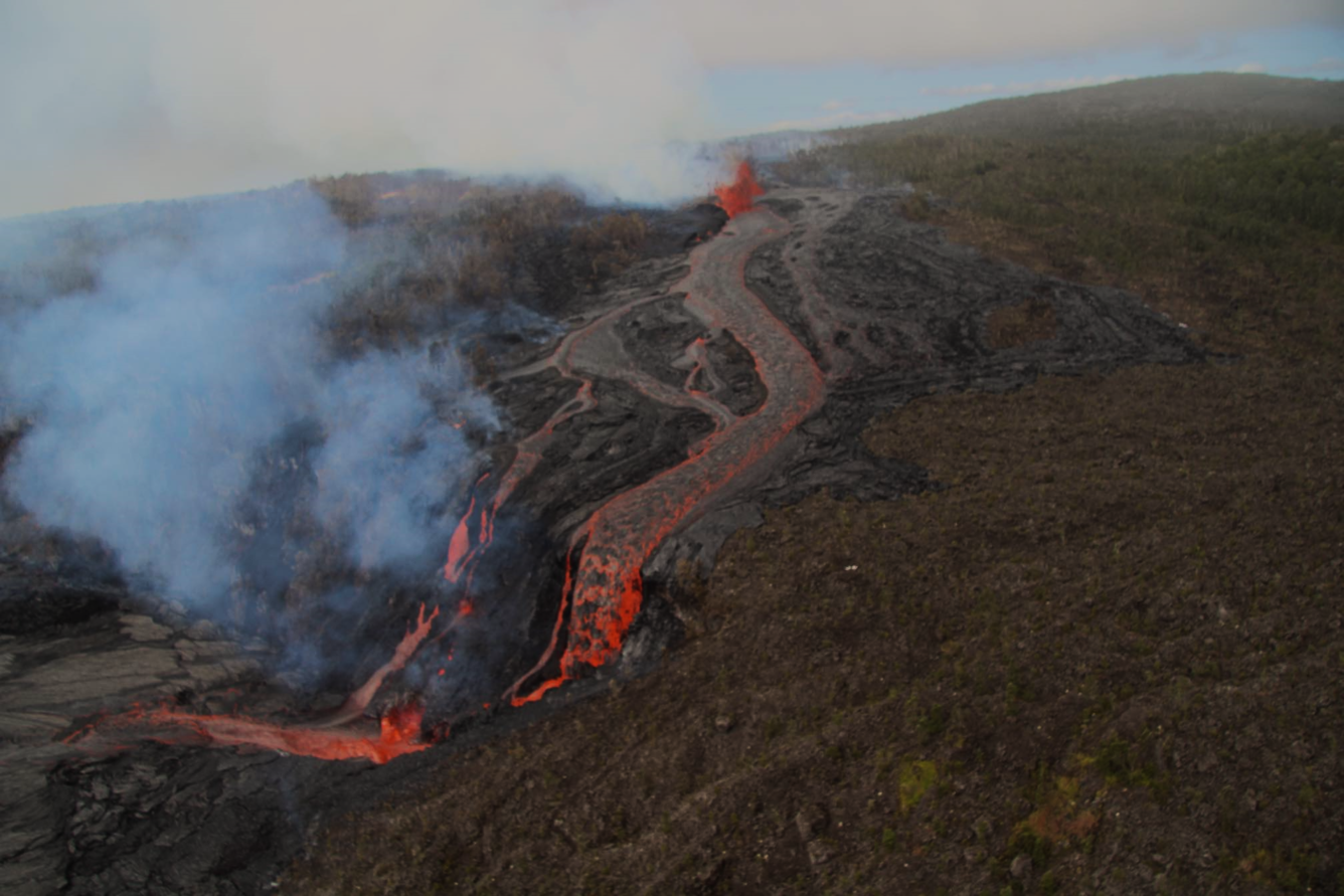
USGS Hawaiian Volcano Observatory geologists conducted a reconnaissance overflight of the eruption near Nāpau Crater on the middle East Rift Zone of Kīlauea. They observed lava cascading over the rim of the crater from a channel more than 50 meters (about 164 feet) wide. Lava is contained within Nāpau Crater and now covers about two thirds of the crater floor.
Rift Zone Observations:
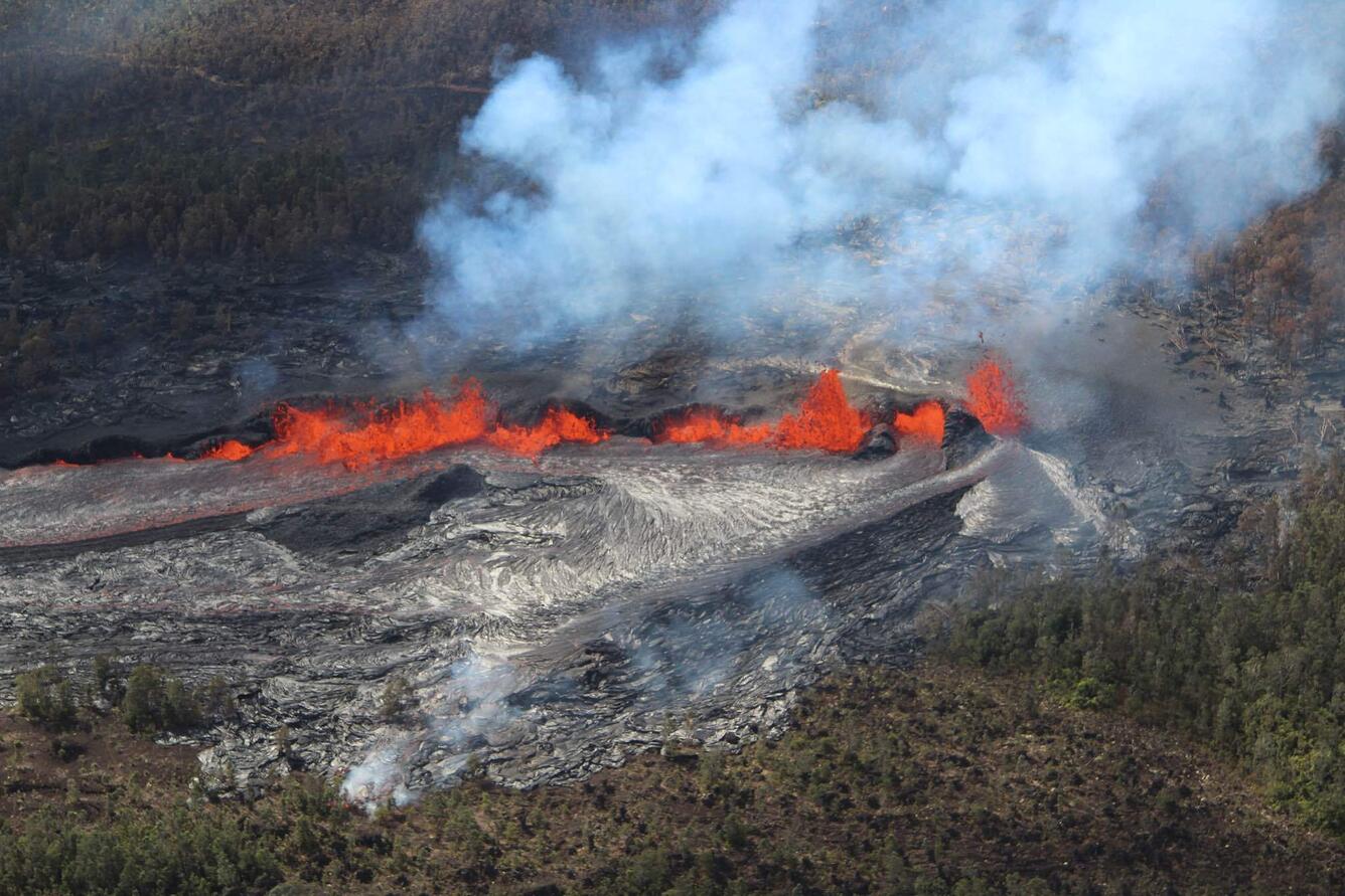
The eruptive fissure west of Nāpau Crater remained active overnight and continues to feed lava cascades into the crater that have covered approximately 250,000 square meters (300,000 square yards) or a third of the crater floor since the new eruption began yesterday afternoon. The rate of coverage indicates lava is erupting at roughly 5-15 cubic meters per second (6-16 cubic yards). At the time of this notice, fountaining remained strong as observed on the S2cam (see link below). In total, approximately two thirds of Nāpau Crater floor (500,000 square meters or about 125 acres) has been covered during this eruption since Sunday night.
Shallow earthquakes remain very low in the MERZ with about 20 in the past 24 hours. Most of these were to the west and northwest of Nāpau Crater. Tremor remains strong on the MERZ seismometers close to the eruption site and increased significantly with the onset of the new vent yesterday.
Tiltmeters in the MERZ continue to show no significant changes. Recent position solutions from GPS instruments have shown displacements of over 20 cm (8 inches) for several stations in the MERZ. The largest displacement is for station MKAI, just downslope of Makaopuhi Crater, which has experienced 54 cm (1.8 feet) of south-southwest motion since September 14. The combination of large GPS displacements and modest tilt rates suggests that much of the deformation is the result of magma entering a storage region several kilometers (1-2 miles) below the surface.
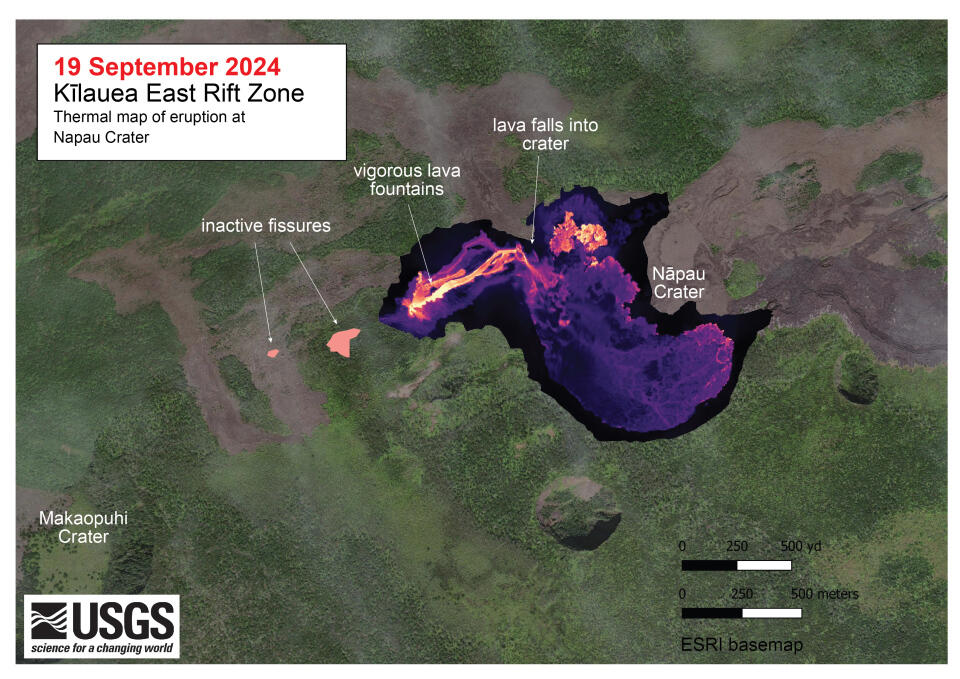
A helicopter overflight on September 19, 2024, allowed for aerial visual and thermal imagery to be collected at the middle East Rift Zone eruption site on Kīlauea. The eruptive activity continues with a fissure vent active west of Nāpau Crater generating lava flows northeast into the crater. The scale of the thermal map ranges from blue to red, with blue colors indicative of cooler temperatures and red colors indicative of warmer temperatures.
Sulfur Dioxide (SO2) emission rates measured yesterday, September 18, were 10,000 tonnes per day for the new vent that opened in the afternoon.
All activity is currently confined to the middle East Rift Zone between Makaopuhi Crater and Puʻuʻōʻō and there are no indications of any changes further downrift in the MERZ or in the LERZ.
Source : HVO
Photos : USGS/ M. Zoeller, USGS.
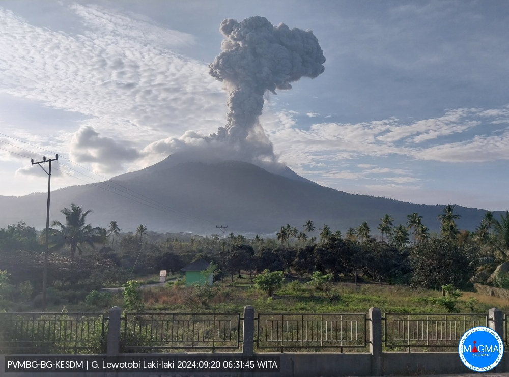
Indonesia , Lewotobi Laki-laki :
An eruption of Lewotobi Laki-laki occurred on Friday, September 20, 2024 at 06:27 WITA with the height of the ash column observed at ± 900 m above the summit (± 2484 m above sea level). The ash column was observed to be gray with a thick intensity, oriented towards the southwest and west. This eruption was recorded on a seismograph with a maximum amplitude of 11.84 mm and a duration of 227 seconds.
VOLCANO OBSERVATORY NOTICE FOR AVIATION – VONA
Issued : September 20 , 2024
Volcano : Lewotobi Laki-laki (264180)
Current Aviation Colour Code : ORANGE
Previous Aviation Colour Code : orange
Source : Lewotobi Laki-laki Volcano Observatory
Notice Number : 2024LWK526
Volcano Location : S 08 deg 32 min 20 sec E 122 deg 46 min 06 sec
Area : East Nusa Tenggara, Indonesia
Summit Elevation : 5069 FT (1584 M)
Volcanic Activity Summary :
Eruption with volcanic ash cloud at 22h27 UTC (06h27 local).
Volcanic Cloud Height :
Best estimate of ash-cloud top is around 7949 FT (2484 M) above sea level or 2880 FT (900 M) above summit. May be higher than what can be observed clearly. Source of height data: ground observer.
Other Volcanic Cloud Information :
Ash cloud moving from southwest to west. Volcanic ash is observed to be gray. The intensity of volcanic ash is observed to be thick.
Remarks :
Eruption recorded on seismogram with maximum amplitude 11.84 mm and maximum duration 227 second.
Source et photo : Magma Indonésie.
Colombia , Nevado del Ruiz :
Manizales, September 17, 2024, 7:00 p.m.
From the monitoring of the activity of the Nevado del Ruiz volcano, the Colombian Geological Survey (SGC), an entity attached to the Ministry of Mines and Energy, reports that:
For the week of September 10 to 16, 2024, the volcano continued with unstable behavior. Compared to the previous week, the main variations in the monitored parameters were:
– The seismic activity associated with the fracturing of rocks inside the volcanic edifice decreased in the number of earthquakes recorded and maintained similar levels in the seismic energy released. The earthquakes were of low energy level, with magnitudes less than 1, and were located in the Arenas crater and, dispersedly, on the different flanks of the volcano, at distances generally less than 3 km from the crater. To a lesser extent, some events were located to the east-southeast and northwest, at distances of up to 10 km from the crater. The depths of the events varied from less than 1 km to 6 km from the summit of the volcano.
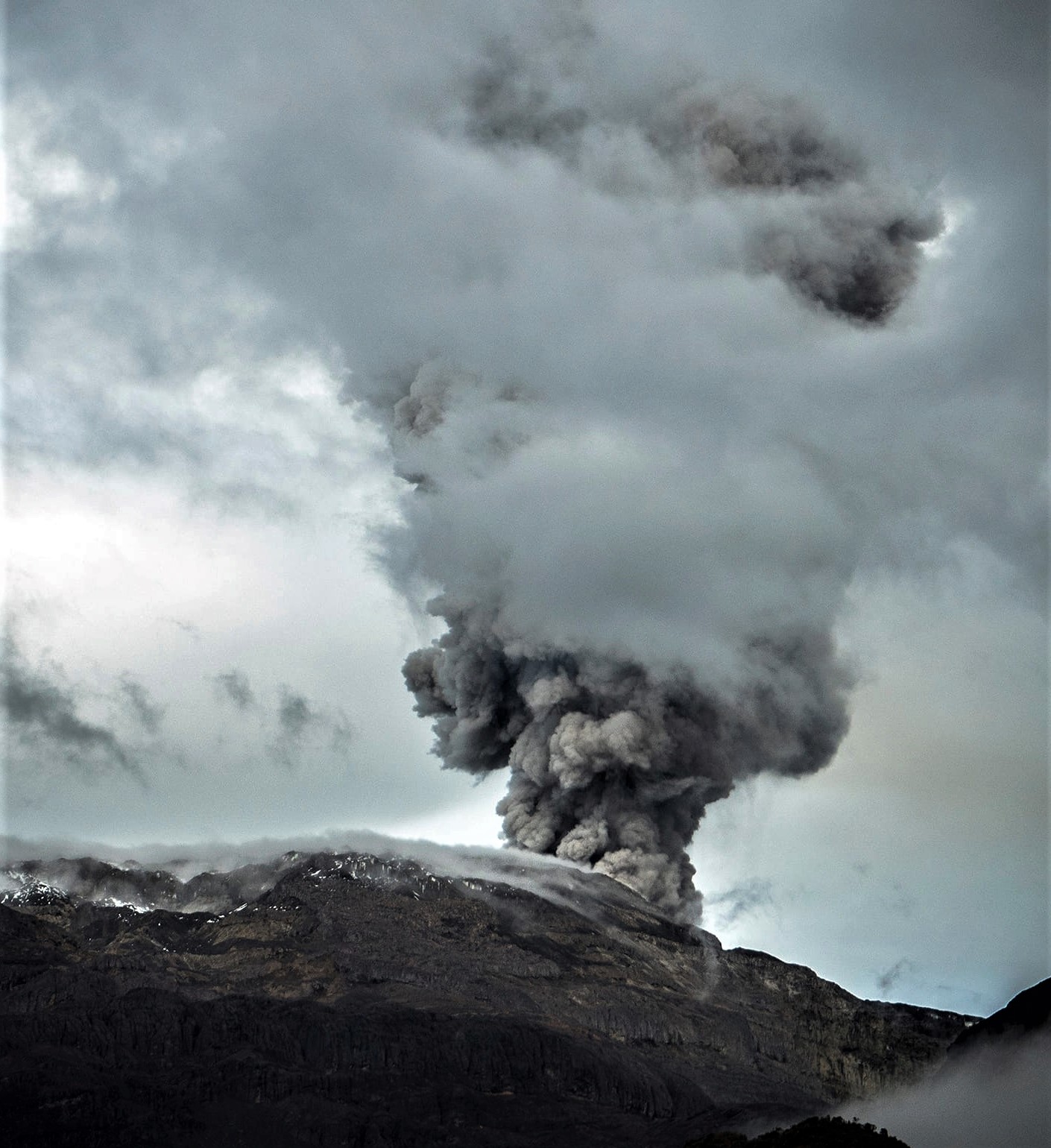
– Seismicity related to the activity of fluids inside volcanic conduits decreased in the number of earthquakes recorded and in the seismic energy released. These seismic signals mostly presented low energy levels and occasionally showed moderate values. Thanks to the cameras used to monitor the volcano, it was possible to confirm some ash emissions and several changes in the temperature of the emitted material, both phenomena being associated with some of these seismic events.
– On the volcano, the emission of water vapor and gases into the atmosphere from the Arenas crater continued. The rates of degassing of sulfur dioxide (SO2) were variable and decreased compared to the previous week. The maximum height of the gas column vertically was 800 m (estimated above the volcanic summit) and in dispersion it reached 300 m on several occasions (September 14, 15 and 17). The direction of dispersion of the gas column maintained a preferential trend towards the northwest and west-northwest of the volcano.
– When monitoring thermal anomalies at the bottom of the Arenas crater, from satellite monitoring platforms, due to the good atmospheric conditions in the area during the week, several anomaly reports were obtained. The energy levels of the anomalies were low and moderate. It is worth noting that since mid-August of the current year, no moderate energy level anomalies have been observed.
Source : SGC
Photo : Álex Palacio( 04/2022 ).
Alaska , Great Sitkin :
Lava continues to erupt slowly at Great Sitkin Volcano. Ongoing activity is adding to a thick lava flow that fills most of the summit crater. The local seismic network continues to detect small earthquakes and other signals associated with the ongoing lava eruption. Satellite and web camera views were clear this morning, but have since become obscured by clouds and fog.
Slightly elevated surface temperatures were observed early this morning; nothing noteworthy was observed in web camera views. A single explosive event occurred in May 2021 and was followed by the ongoing eruption of lava that began in July 2021. No explosive events have occurred since May 2021. Local seismic and infrasound sensors and web cameras are used to monitor Great Sitkin along with regional infrasound and lightning networks and satellite data.
Source : AVO
Photo : Loewen, Matt (10/2023 ).
Guatemala , Santiaguito :
Atmospheric conditions: Partly cloudy.
Wind: Northeast.
Precipitation: 5.0 mm.
Activity:
The Santa María-Santiaguito Volcanic Complex Observatory reports volcanic activity on the Caliente Dome. During the night and early morning, between 2 and 6 weak to moderate explosions were recorded per hour, although the weather was partly cloudy. Among the clouds, some moderate explosions were observed that raised columns of gas and ash up to 800 meters above the dome. , as well as the incandescence of lava extrusion in the dome, block avalanches and pyroclastic flows at short distances towards the west, southwest and south flanks, which generally reach the base of the dome. The stacking of these pyroclastic materials on these flanks forms a promontory above the lava flow of the year 2022 which occupies the channels of Zanjón Seco and San Isidro.
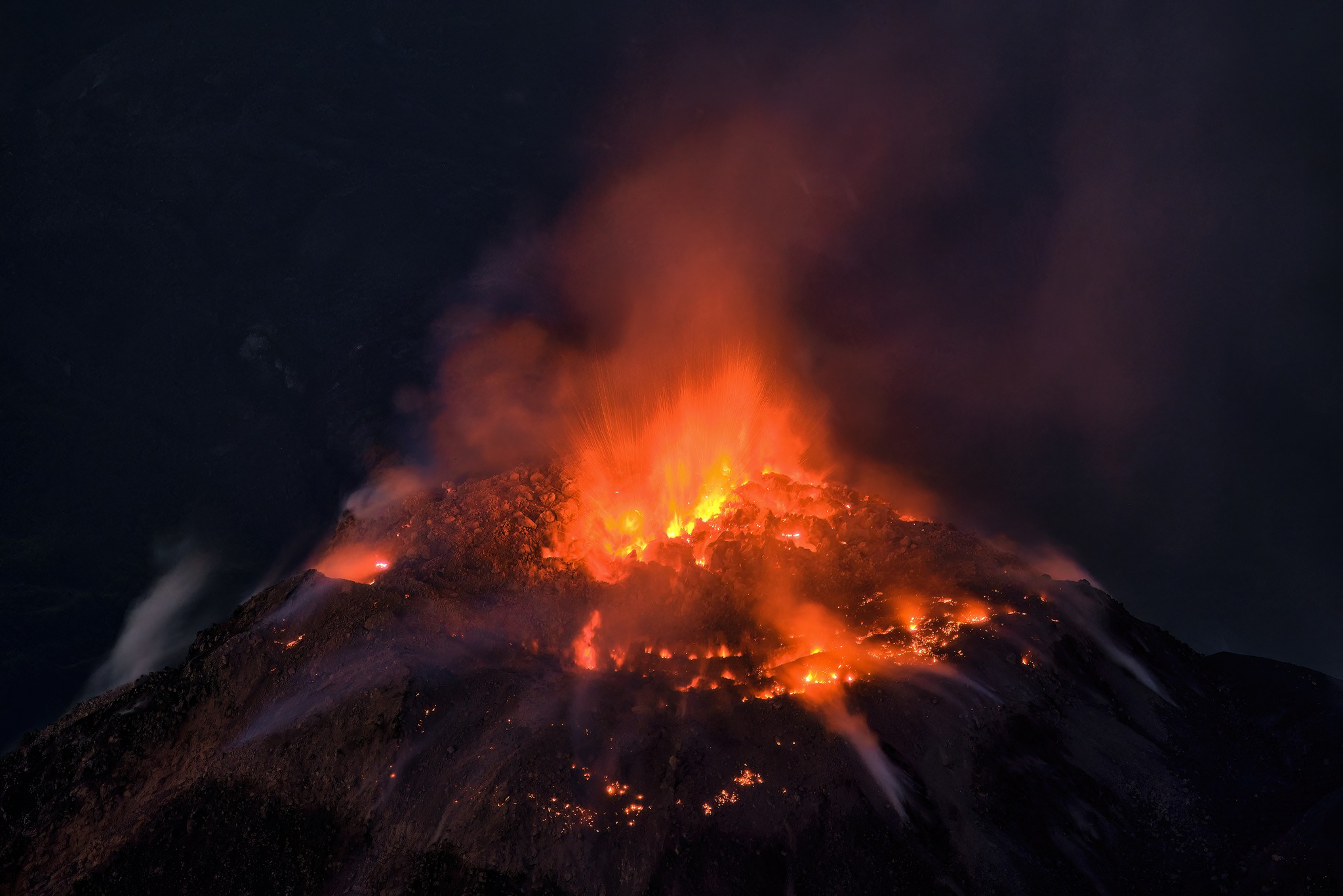
Degassing is constant, with weak to moderate columns of water vapor and other magmatic gases rising 300 meters above the dome, moving toward the west and southwest. Due to the wind direction, weak ash falls may occur on Loma Linda, Montebello and San Marcos Palajunoj. In the afternoon and night, rains could cause lahars to descend into the channels that descend from the Caliente dome. Activity remains at a high level, so it is possible that with the explosions or under the effect of gravity, some of the accumulated material will collapse and that pyroclastic flows over long distances will be generated toward the southwest, south and southeast.
Source : Insivumeh
Photo : Thomas Spinner via FB ( 06/2023) .