September 13 , 2024.
Philippines , Kanlaon :
KANLAON VOLCANO POSSIBLY RAISED TO ALERT LEVEL 3; RESIDENTS PREPARED FOR POSSIBLE FORCED EVACUATION
Due to the continued activity of Kanlaon, residents near the volcano remain on alert whenever the LGU of La Carlota City and La Castellana in Negros Occidental orders a forced evacuation.
In La Castellana, classes are still suspended at all levels.
In La Carlota City, there are still no schools in Barangays Ara-al, Haguimit, San Miguel, and Yubo, which are near the volcano.
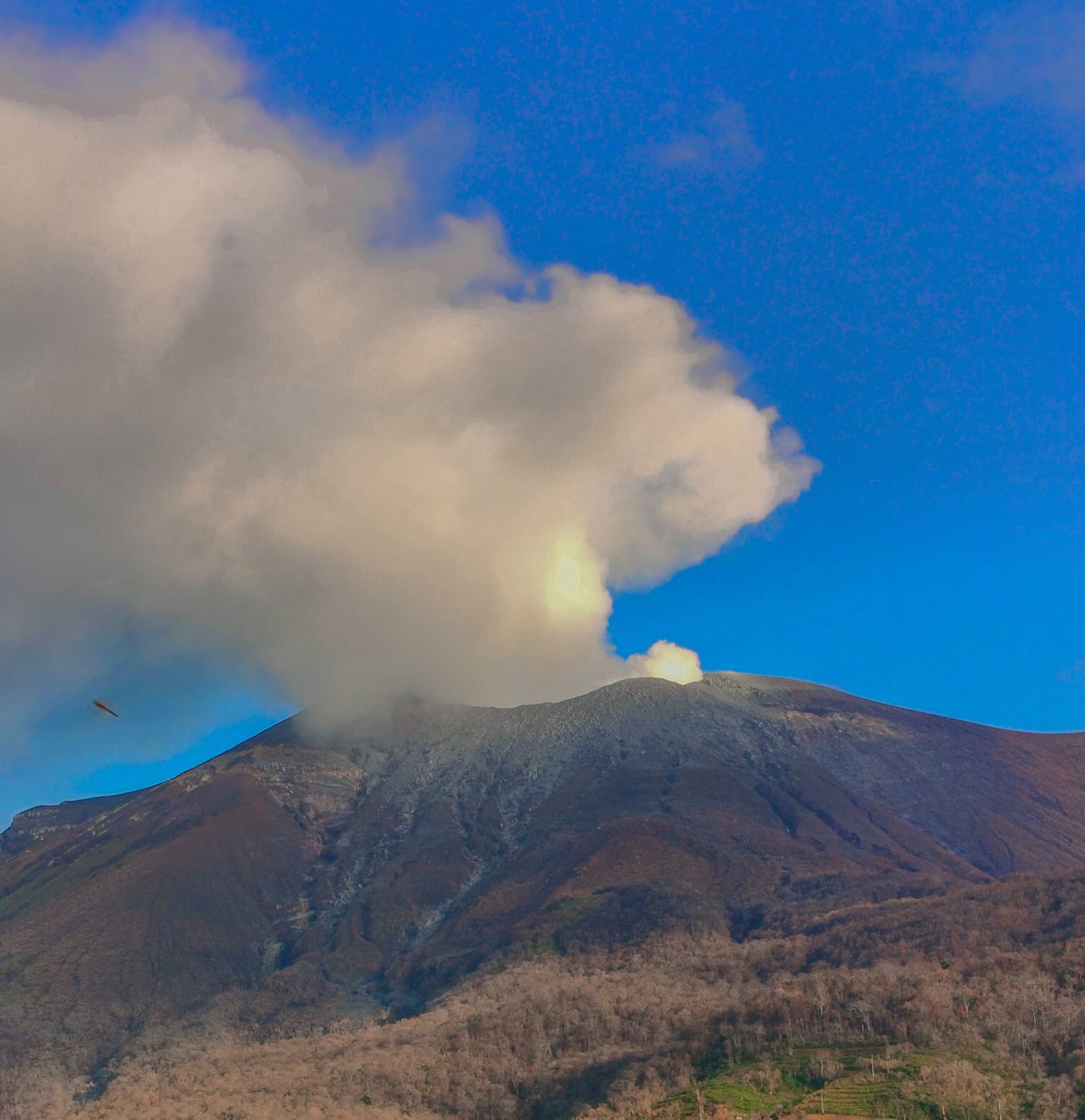
In 24 hours, Mount Kanlaon emitted more than 11,000 tons of sulfur. 79 volcanic earthquakes were also recorded.
Due to the parameters, the possibility of raising the volcano to Alert Level 3 has increased, according to PHIVOLCS.
« Our S02 emission is the highest. We can raise it to Alert Level 3. We can also expect magmatic incursion under the volcano. At any time, we can have an eruption, which is dangerous for people who are near the volcano, » said Eng. Mari Andylene, resident volcanologist of the Kanlaon Volcano Observatory via GMA Regional One Western Visayas.
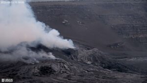
Hundreds of people fled their homes in the Philippines on Wednesday after Kanlaon Volcano spurted harmful gases, an official said, as experts warned of a potential eruption.
About 300 residents of villages within four kilometers (2.5 miles) of the Kanlaon Volcano crater in the center of the country were evacuated on Tuesday as a precaution, the local government of nearby Canlaon City said.
The evacuees have taken temporary shelter at schools and community centres away from the volcano, city information officer Edna Lhou Masicampo told AFP on Wednesday.
« People from villages near the foot of the volcano have been complaining about the strong smell of sulphur, » Masicampo said, adding most of the residents were farmers.
Classes were suspended and some tourist spots in the city of around 60,000 people were closed on Wednesday due to the volcano warning.
Kanlaon’s daily average emission of sulphur dioxide almost tripled to 9,985 tons on Tuesday.
Sources : GMA news , Philstar .
Photos : GMA news via Sherine France , Bebie Sarol .
Indonesia , Lewotobi Laki-laki :
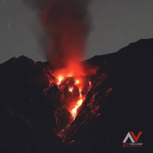
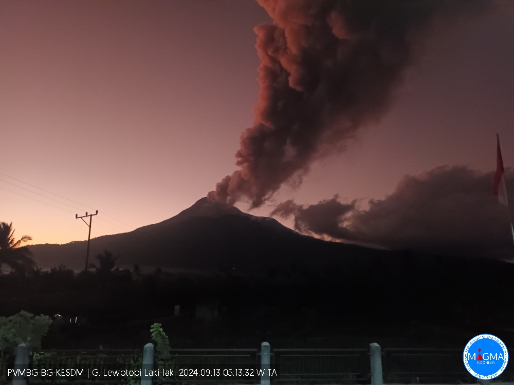
An eruption of Lewotobi Laki Laki occurred on Friday, September 13, 2024 at 05:07 WITA with the height of the ash column observed at ± 900 m above the summit (± 2484 m above sea level). The ash column was observed to be gray with a thick intensity, oriented towards the West. This eruption was recorded on a seismograph with a maximum amplitude of 22.2 mm and a duration of 598 seconds.
VOLCANO OBSERVATORY NOTICE FOR AVIATION – VONA
Issued : September 13 , 2024
Volcano : Lewotobi Laki-laki (264180)
Current Aviation Colour Code : ORANGE
Previous Aviation Colour Code : orange
Source : Lewotobi Laki-laki Volcano Observatory
Notice Number : 2024LWK497
Volcano Location : S 08 deg 32 min 20 sec E 122 deg 46 min 06 sec
Area : East Nusa Tenggara, Indonesia
Summit Elevation : 5069 FT (1584 M)
Volcanic Activity Summary :
Eruption with volcanic ash cloud at 21h07 UTC (05h07 local).
Volcanic Cloud Height :
Best estimate of ash-cloud top is around 7949 FT (2484 M) above sea level or 2880 FT (900 M) above summit. May be higher than what can be observed clearly. Source of height data: ground observer.
Other Volcanic Cloud Information :
Ash cloud moving from west to northwest. Volcanic ash is observed to be gray. The intensity of volcanic ash is observed to be thick.
Remarks :
Eruption recorded on seismogram with maximum amplitude 22.2 mm and maximum duration 598 second.
Source et photo : Magma Indonésie.
Colombia , Nevado del Ruiz :
Manizales, September 10, 2024, 6:30 p.m.
From the monitoring of the activity of the Nevado del Ruiz volcano, the Colombian Geological Survey (SGC), an entity attached to the Ministry of Mines and Energy, reports that:
During the week of September 3 to 9, 2024, the volcano continued with unstable behavior. Compared to the previous week, the main variations in the monitored parameters were:
– The seismic activity associated with the fracturing of rocks inside the volcanic edifice decreased in the number of earthquakes recorded and in the seismic energy released. The earthquakes were of low energy level, with magnitudes less than 1, and were located in the Arenas crater and on the different flanks of the volcano, mainly in the South-Southwest and Northeast sectors, at distances of less than 3 km from the crater. To a lesser extent, the earthquakes were located in the East-Southeast sector, at distances between 6 and 8 km from the crater. The depths of the events varied between less than 1 km and 6 km from the summit of the volcano.

– Seismicity related to the activity of fluids inside volcanic conduits decreased in the number of earthquakes recorded and increased slightly in the seismic energy released. The energy levels of the seismic signals varied between weak and moderate. On September 6, and since noon today, this type of seismic signals stood out for their duration. Thanks to the cameras used to monitor the volcano, it was possible to confirm some ash emissions, as well as several changes in the temperature of the emitted material, two phenomena associated with some of these seismic events.
– The emission of water vapor and gases into the atmosphere from the Arenas crater continued. The degassing rates of sulfur dioxide (SO₂) were variable and increased compared to those recorded the previous week. On September 3 and 6, the gas column reached a maximum vertical height of 1,400 m (estimated above the volcanic summit).
In addition, on September 3, the column dispersion height was 2,000 m, an estimated value during the ash emission recorded at 00:43 . The gas column dispersion direction maintained a preferential trend towards the northwest of the volcano.
– By monitoring thermal anomalies at the bottom of the Arenas crater, from satellite monitoring platforms, several reports of low-energy anomalies were obtained.
Source et photo : SGC.
Chile , Villarica :
Seismology
The seismological activity of the period was characterized by the recording of:
A continuous seismic tremor signal associated with the fluid dynamics inside the volcano, which during the period and evaluated with the RSAM parameter, presented energy values between 0.1 and 0.3 μm/s.
37 VT type seismic events, associated with rock fracturing (Volcano-Tectonic). The most energetic earthquake had a Local Magnitude (ML) value equal to 2.4, located 5.4 km south-southeast of the volcanic edifice, at a depth of 3.5 km from the crater.
843 LP type seismic events, associated with the fluid dynamics inside the volcanic system (Long Period). The size of the largest earthquake evaluated from the Reduced Displacement (DR) parameter was equal to 9 cm2.
35 TR-type seismic events, associated with the dynamics maintained over time of the fluids inside the volcanic system (TRemor). The size of the largest earthquake evaluated from the Reduced Displacement (DR) parameter was equal to 5 cm2.
Fluid Geochemistry
The sulfur dioxide (SO2) emission data obtained by the Differential Optical Absorption Spectroscopy (DOAS) equipment, corresponding to the Los Nevados and Tralco stations, installed respectively 10 km in an East-Northeast direction and 6 km East-Southeast from the active crater, presented an average value of 554 ± 78 t/d, which represents moderate values for this volcanic system. The maximum daily value was 619 t/d on August 20, which corresponds to surface activity.
No anomalies were reported in the emissions of sulfur dioxide (SO2) into the atmosphere in the area near the volcano, according to data published by the Tropospheric Monitoring Instrument (TROPOMI) and the Sulfur Dioxide Group of the Ozone Monitoring Instrument (OMI).
Thermal anomalies by satellites
During the period, 2 thermal alerts were recorded in the area associated with the volcano, according to the analytical processing of Sentinel 2-L2A satellite images, in combination with false color bands, on August 17 and 24.
Geodesy
The analysis of geodetic data, based on data from 5 GNSS stations installed on the volcano, indicates that:
– The horizontal and vertical displacement rates have moderate amplitudes and, in general, they are influenced by cyclical variations of an annual nature, data loss and increased dispersion in the time series. For the current period, vertical variation rates close to zero are generally reported, with a maximum estimated at 0.3 cm/month.
– The variation in distance between the different GNSS stations shows slight variations during this period, while maintaining the trend calculated over the last 3 months.
– Using radar interferometry, no evidence of deformation in the area is determined.
Based on the trends and directions of displacements in the current period, no deformation patterns are observed at the level of the volcanic edifice suggesting changes.
Surveillance cameras
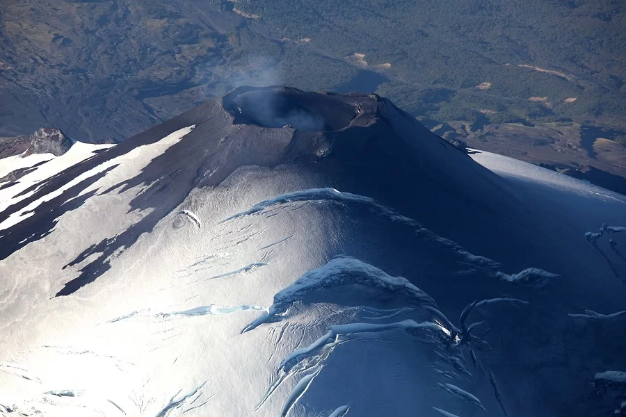
During this fortnight, low-altitude degassing, mostly whitish, was recorded from the crater, with a maximum height of 300 m on August 27. Concerning events with pyroclast emission, there was only one recording on August 29. When weather conditions permitted, incandescence was occasionally observed.
Satellite geomorphological analysis
From the analysis of SkySat Collect satellite images, the deposits associated with the explosion of August 29 are identified, with ranges from the center of the crater of 624 m in the West direction and 183 m East. It is not possible to see exposed melting areas inside the crater.
The volcano remains with a stable seismic behavior and values considered energetically low, in turn, the infrasound sensors do not present notable acoustic signals.
Regarding surface activity, pulsatile degassing at low altitude predominates. The occurrence of at least one minor explosion that propelled pyroclastic material into the area surrounding the crater stands out. Although a decrease in monitoring signals is evident, it is deduced that there is still evidence of the permanence of an active lava lake located at shallow levels.
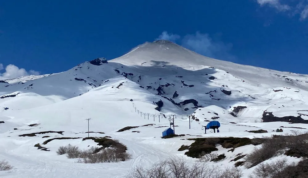
For this reason, its potential impact radius by volcanic products is maintained at 1 km measured from the center of the main crater and the technical volcanic alert is yellow.
YELLOW TECHNICAL ALERT: Changes in the behavior of volcanic activity
Observation: The probable impact zone is considered to be located within a radius of 1 km around the center of the crater.
Source : Sernageomin
Photos : Aton ( 3/2024) , Auracaniadiario ( 11/2023).
Guatemala , Fuego :
Altitude: 3,763 meters .
Atmospheric conditions: Clear.
Wind: Southeast.
Precipitation: 0.0 mm.
Activity:
OVFGO reports weak to moderate explosions at frequencies of 5 to 9 per hour, observing ash columns between 4,500 and 4,800 meters (14,763 to 15,748 feet) dispersing west, northwest, about 30 km. Ashfall is recorded in the villages of Sangre de Cristo, Palo Verde, San Pedro Yepocapa, La Soledad, Parramos, with the probability of spreading to Chimaltenango and others in this area.

Some explosions generate rumblings, shock waves and noises similar to those of a locomotive. Strong explosions expel ballistic projectiles onto the plateau, making it dangerous to climb and/or stay there. Take into account that in the afternoon and at night, moderate and heavy rains are generated in the volcanic area, so lahars may continue to be generated. It is recommended to take precautions when passing vehicles through rivers and ravines around the volcano.
Source : Insivumeh
Photo : Conred (2021).