August 15 , 2024.
Italy / Sicily , Etna :
August 14, 2024 7:15 p.m. (5:15 p.m. UTC), Press release on the activity of Etna.
The National Institute of Geophysics and Volcanology, Osservatorio Etneo, communicates that from images from surveillance cameras, we observe an intensification of Strombolian activity at the level of the Voragine crater. The predicted dispersion model of the possible volcanic cloud indicates an East-South-East direction.
Over the past week, the volcanic tremor showed a gradual increase from low to medium values until 15:00 UTC today, when a sudden increase to high values was recorded.
The locations of the sources of the tremor are located in the east of Voragine at an altitude of approximately 3000 meters.
Infrasound activity is concentrated at the Voragine crater; the number of hourly events and amplitude have not changed significantly over the past few hours. The GNSS network and the DRUV dilatometric station do not show significant variations. The inclinometer network today presents variations at the CBD station, with an oscillating trend.
August 15, 2024 01:02 (23:02 UTC), Press release on the activity of Etna.
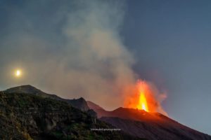
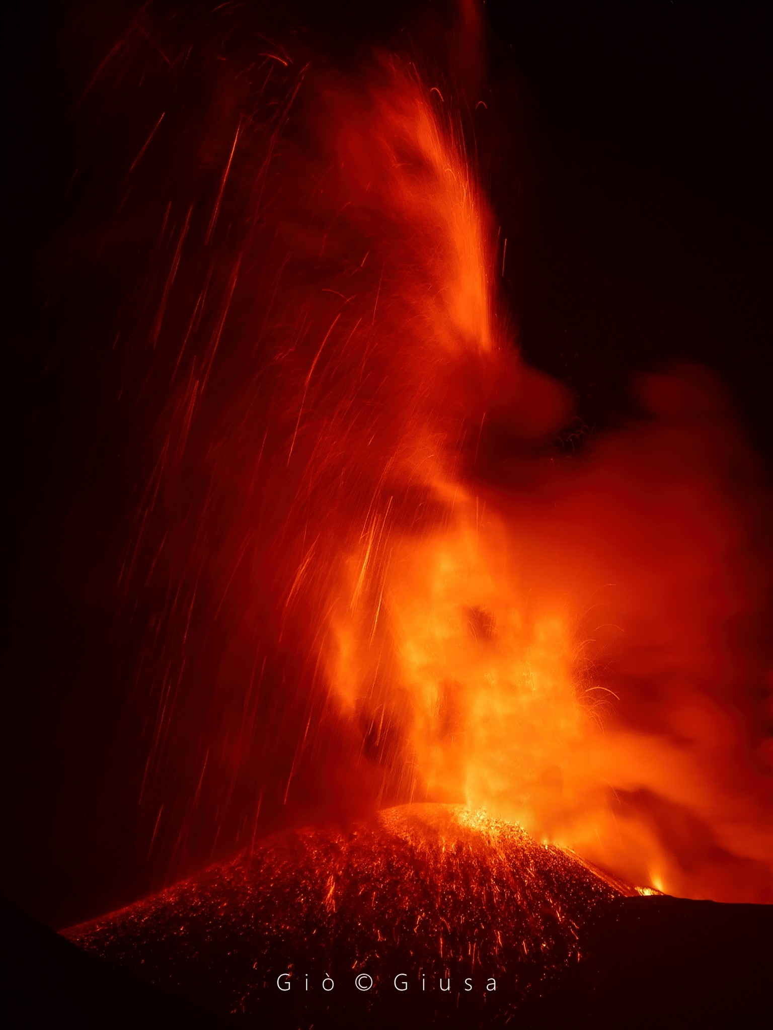
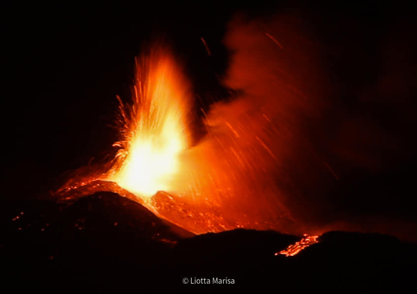
The National Institute of Geophysics and Volcanology, Osservatorio Etneo, communicates that according to images from surveillance cameras, we observe that the Strombolian activity of the Voragine crater, which had previously intensified (see updated press release at 17:15 UTC), gradually evolved into a lava fountain. This activity is currently underway and produces an ash cloud which, in accordance with the forecast model, disperses in the East-South-East direction with, for the moment, ash fallout in the area of Piano Vetore, Nicolosi and Ragalna. Light ash fall was also reported in Catania. We also observe that this activity feeds an overflow of lava from the western edge of the Bocca Nuova crater.
The volcanic tremor has been increasing steadily and does not appear to have reached its maximum value at the moment. The locations of the sources of the tremor correspond to Voragine at an altitude of approximately 3000 meters.
The infrasound activity increased significantly both in number of events and in amplitude and is located in correspondence with the Voragine crater.
The GNSS network data does not show significant variations. The inclinometer network shows variations at the summit stations of the CPN and the PDN, of the order of 1.5 and 0.4 mrad respectively.
August 15, 2024 04:28 (02:28 UTC), Press release on the activity of Etna.
The National Institute of Geophysics and Volcanology, Osservatorio Etneo, communicates that from the images of the surveillance cameras it can be observed that the lava fountain, described in the previous update statement, has gradually been exhausted from from around 00:30 UTC and ceased around 00:30 UTC. 01:20 UTC. The lava fountain produced an eruptive cloud which, in its most intense phase, reached a height of approximately 9.5 km above sea level and was mainly dispersed in the South-Southwest sectors. and East-Southeast. Fallout of pyroclastic material was reported in the Piano Vetore area and in Nicolosi, Ragalna and Pedara. Light ash fall was also reported in Catania. During the lava fountain, lava overflows were also produced from the western rim of the Bocca Nuova crater.
Currently, weak explosive activity persists at the Voragine crater.
The volcanic tremor, after reaching the maximum value at 22:50 UTC, began a rapid decrease until currently reaching average values. The sources of the earthquake, located in Voragine during the phase of maximum amplitude of the earthquake, have been located slightly further east since 01:00 UTC.
Infrasound activity has decreased considerably and currently only a few events are located between Voragine and the Northeast crater.
During the lava fountain, the GNSS network did not show significant variations. The inclinometer network measured variations of the order of 1.0 and 3.5 mstrain at the PDN and CPN summit stations, respectively. The DRUV dilatometric station measured a total decompression of around 300 nstrain, from 18:40 UTC until 00:50 UTC.
Further updates will be communicated shortly.
Source : INGV
Photos : Gio Giusa , Marisa Liotta . (14/08/2024)
Philippines , Kanlaon :
PHIVOLCS issued a special notice for Kanlaon at 2330 on 10 August noting increased sulfur dioxide emissions. Earlier in the day a Flyspec instrument measured an average of 4,839 tonnes per day (t/d) of sulfur dioxide emissions at the summit crater, the third highest value recorded in 2024. Gas emissions rose 400-600 m above the carter rim and drifted SE and NE during 10-13 August. Another special notice was issued at 1830 on 13 August noting that the Flyspec instrument measured an average of 7,307 t/d, the highest sulfur dioxide emissions ever recorded at the volcano.
Higher sulfur dioxide gas fluxes had been recorded in 2024 with an average of 1,273 t/d prior to the 3 June eruption; afterward the eruption emissions were elevated, averaging 3,102 t/d. An average of nine volcanic earthquakes per day also persisted after the 3 June eruption. Ground deformation data from continuous GPS and electronic tilt data indicated inflation of the volcano since March 2022 and specifically at the E flank starting in 2023. The Alert Level remained at 1 (on a scale of 0-5) and PHIVOLCS reminded the public to remain outside of the 4-km-radius Permanent Danger Zone.
Sources : Institut philippin de volcanologie et de sismologie (PHIVOLCS) , GVP.
Photo : Sunstar
Japan , Suwanosejima :
JMA reported that eruptive activity at Suwanosejima’s Ontake Crater continued during 5-12 August. Crater incandescence was observed nightly in webcam images. Eruptive events were recorded at 21h09 on 6 August, at 00h56, 01h24, 02h36, 03h13, 03h49, 065h7, and 09h55 on 7 August, and at 02h07, 11h56, 12h25, and 14h40 on 8 August. Ash plumes rose 1-1.4 km above the crater rim and drifted mainly SW, S, and SE. Explosions were recorded at 14h57, 16h25, and 17h17 on 10 August, though emissions were not visually observed. Explosions at 21h03 on 10 August, at 10h11 and 12h13 on 11 August, and at 00h54 and 02h07 on 12 August generated ash plumes that rose 200-600 m above the crater rim and drifted SE; sometimes the plumes rose into weather clouds. The Alert Level remained at 2 (on a 5-level scale) and the public was warned to stay at least 1.5 km away from the crater.
The 8-km-long island of Suwanosejima in the northern Ryukyu Islands consists of an andesitic stratovolcano with two active summit craters. The summit is truncated by a large breached crater extending to the sea on the E flank that was formed by edifice collapse. One of Japan’s most frequently active volcanoes, it was in a state of intermittent Strombolian activity from Otake, the NE summit crater, between 1949 and 1996, after which periods of inactivity lengthened. The largest recorded eruption took place in 1813-14, when thick scoria deposits covered residential areas, and the SW crater produced two lava flows that reached the western coast. At the end of the eruption the summit of Otake collapsed, forming a large debris avalanche and creating an open collapse scarp extending to the eastern coast. The island remained uninhabited for about 70 years after the 1813-1814 eruption. Lava flows reached the eastern coast of the island in 1884. Only about 50 people live on the island.
Sources : Agence météorologique japonaise (JMA) , GVP.
Photo : eri .u tokyo.ac ( archive)
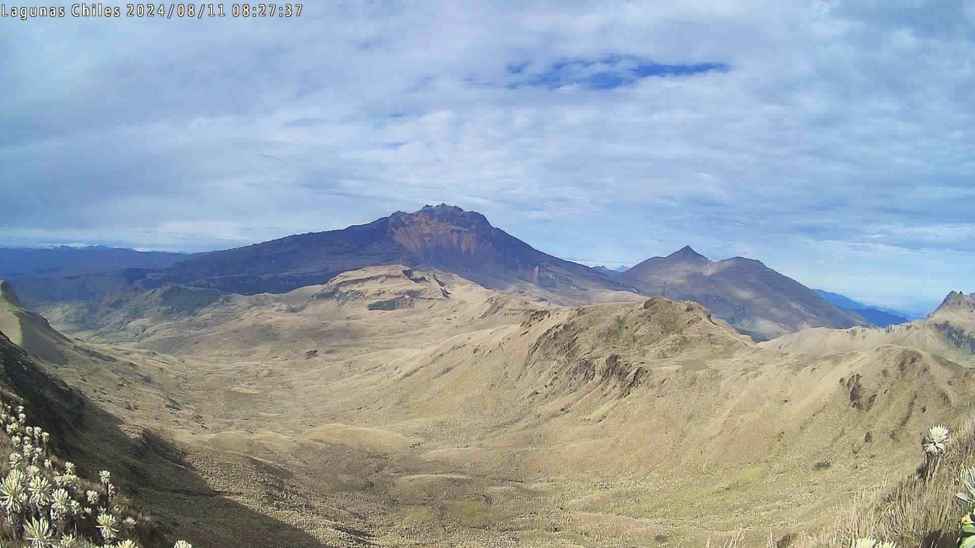
Colombia , Chiles / Cerro Negro :
Pasto, August 13, 2024, 4:25 p.m. Chiles and Cerro Negro Volcanoes
From monitoring the activity of the Chiles and Cerro Negro volcanoes, the Colombian Geological Service (SGC), an entity attached to the Ministry of Mines and Energy, reports that:
In the week of August 6 to 12, 2024, the activity of these volcanoes maintained stable behavior. Compared to the previous week, the main variations in the parameters monitored were:
• Increased frequency of earthquakes and seismic energy released.
• The predominance of seismicity associated with fracturing of rock materials continues.
• The recording of seismicity linked to the movement of fluids inside these volcanoes persists, with some of these events having very low frequency content.
• Earthquakes linked to fracture processes were located, for the most part, north of the summit of the Chiles volcano, in the collapse zone, at distances less than 2 km and at depths between 2 and 5 km relative to the summit. (4700m). Other events took place to the south and southeast of Chiles Volcano, at distances of up to 9 km and depths of up to 8 km from its summit.
• Highlighted are earthquakes of magnitude 2.8, maximum magnitude of the week evaluated, occurring on August 9 and 11 at 5:43 p.m. and 2:09 p.m., respectively, with no reports of felt earthquakes.
• Field strain sensors and remote satellite sensors continue to record changes associated with an inflationary process in the volcanic area.
Based on the above, the SGC recommends carefully monitoring developments through weekly bulletins and other information published through our official channels, as well as instructions from local and departmental authorities and the National Risk Management Unit of Disasters (UNGRD).
Volcanic activity remains on yellow alert: active volcano with changes in the behavior of the base level of monitored parameters and other manifestations.
Source et photo : SGC.
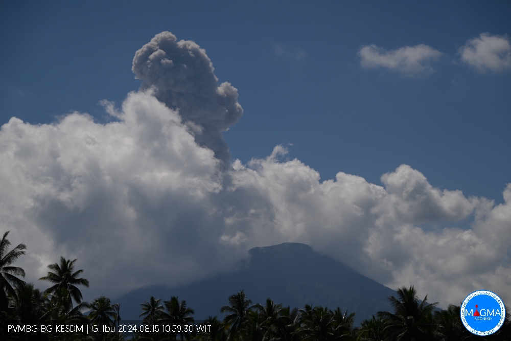
Indonesia , Ibu :
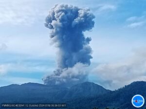
An eruption of Mount Ibu occurred on Thursday, August 15, 2024 at 11:57 a.m. WIT with the height of the ash column observed at ±1,500 m above the summit (±2,825 m above the level of the sea). The ash column was observed to be gray with thick intensity, oriented towards the West. This eruption was recorded on a seismograph with a maximum amplitude of 28 mm and a duration of 85 seconds.
VOLCANO OBSERVATORY NOTICE FOR AVIATION – VONA
Issued : August 15 , 2024
Volcano : Ibu (268030)
Current Aviation Colour Code : ORANGE
Previous Aviation Colour Code : orange
Source : Ibu Volcano Observatory
Notice Number : 2024IBU456
Volcano Location : N 01 deg 29 min 17 sec E 127 deg 37 min 48 sec
Area : North Maluku, Indonesia
Summit Elevation : 4240 FT (1325 M)
Volcanic Activity Summary :
Eruption with volcanic ash cloud at 02h57 UTC (11h57 local).
Volcanic Cloud Height :
Best estimate of ash-cloud top is around 9040 FT (2825 M) above sea level or 4800 FT (1500 M) above summit. May be higher than what can be observed clearly. Source of height data: ground observer.
Other Volcanic Cloud Information :
Ash cloud moving to west. Volcanic ash is observed to be gray. The intensity of volcanic ash is observed to be thick.
Remarks :
Eruption recorded on seismogram with maximum amplitude 28 mm and maximum duration 85 second.
Source et photo : Magma Indonésie .