July 27 , 2024.
Italy , Stromboli :
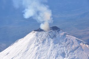
Press release on Stromboli activity, July 26, 2024, 9:17 p.m. (7:17 p.m. UTC).
The National Institute of Geophysics and Volcanology, Osservatorio Etneo, reports significant explosions.
Press release on Stromboli activity, July 26, 2024, 9:48 p.m. (7:48 p.m. UTC).
The National Institute of Geophysics and Volcanology, Osservatorio Etneo, communicates that at 7:16 p.m. UTC, a major explosion was observed thanks to surveillance cameras.
From a seismic point of view, the analysis of the seismograms highlights the presence of a seismic transient lasting approximately 3 minutes at 7:15 p.m. UTC which can be correlated to the major explosion. The average amplitude of the volcanic tremor showed a sudden increase from 19:00 UTC, which brought the values from average to very high. Around 19:30 UTC the amplitude returned to average values.
The signals from the ground deformation monitoring networks (GNSS-HF and inclinometer) do not show significant variations.
Further updates will be communicated shortly.
Source : INGV
Photo : Stromboli stati d’animo / Sebastiano Cannavo.
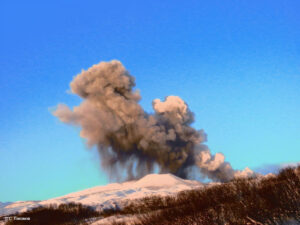
Iceland , Reykjanes Peninsula :
The chances of a magma flow and even an eruption increase
A magma flow without eruption can create danger and cause damage
Updated July 26 at 10:30 a.m.
Seismic activity in recent days has increased slightly, but still remains quite low
Magma accumulation and land elevation continue at a steady pace
We must continue to expect new magma flows and even eruptions in the next two weeks
A magma flow without eruption can create danger and damage in Grindavík
Seismic activity in recent days has increased slightly, but still remains quite low. More than 30 earthquakes have been recorded near the magma tunnel in the Sundhnjúk crater series in the past 24 hours and almost 130 in the past week. Most of them are smaller than M1 and are in similar locations to previous events. For comparison, on the eve of the last eruption, more than 50 earthquakes were recorded daily.
Magma accumulation and land elevation continue at a steady pace
The latest GPS data and satellite images confirm that land elevation and magma accumulation are continuing at a fairly sustained pace over the past few weeks. If the pace remains the same, we can expect a new magma flow and even an eruption in the next two weeks.
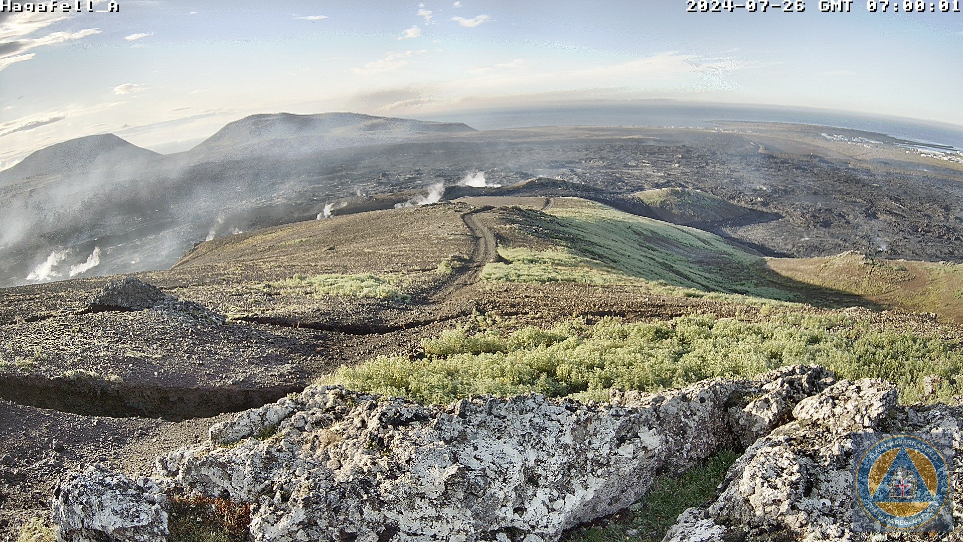
Screenshot from a surveillance camera in Hagafell taken at 7:00 a.m. on July 26. The camera is oriented towards the South-East. Steam rises from the fissure outside Hagafell.
A magma flow without eruption can create danger and cause damage
In a press release earlier this week, the Norwegian Meteorological Agency published two scenarios in the event of an eruption. In the second scenario, there was discussion of the possibility that lava could erupt in Grindavík, creating a danger and causing damage. However, a magma flow without eruption can also create danger and cause damage.
« In the 7 times that magma flowed from Svartsengi to the Sundhnúks crater series, we had eruptions 5 times. So we have to reckon with the possibility of a magma flow without an eruption, » explains Benedikt G. Ófeigsson, head of deformation measurements at the Icelandic Meteorological Office. So far, magma has worked its way from the magma chamber beneath Svartsengi to the Sundhnúks series of craters just east of Sýlingarfell and from there south towards Hagafell. « It is important to realize that if we get a powerful flow of magma from Svartsengi, it is possible that the resulting magma tunnel will reach south of Hagafell and this will likely cause significant fissure movements in Grindavík, even if it there is no eruption. The greatest damage to infrastructure and property in Grindavík was precisely due to the crack movements during the events of November 10, 2023 and January 14, 2024,” explains Benedikt.
Source et photo : Vedur is
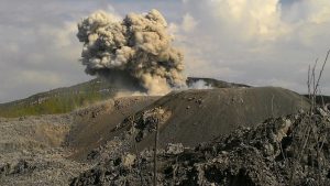
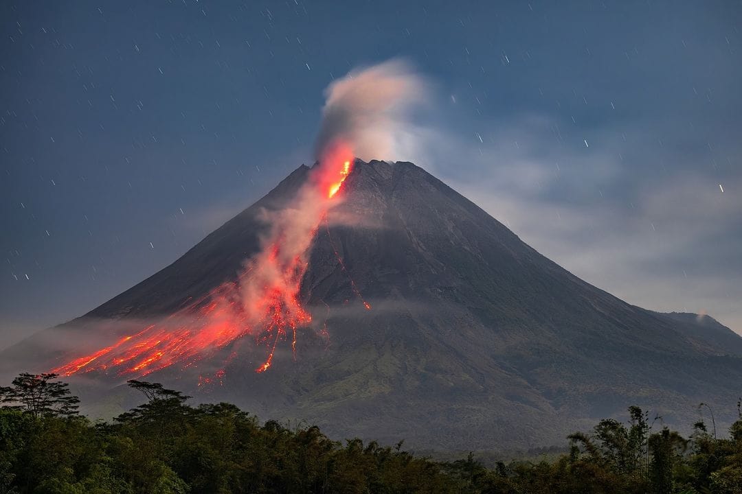
Indonesia , Merapi :
MOUNT MERAPI ACTIVITY REPORT, July 19 to 25, 2024
Published on July 26, 2024
OBSERVATION RESULT
Visual
The weather around Mount Merapi is generally clear in the morning and night, while it is foggy from noon to evening. White smoke, thin to thick, low to moderate pressure and 200 m high was observed from the observation post of Mount Merapi Babadan on July 24, 2024 at 09:52 WIB. This week, 5 warm clouds fell towards the southwest (upstream of the Bebeng River) with a maximum sliding distance of 1,200 m. Lava avalanches were observed 126 times upstream of the Bebeng River over a maximum distance of 1,900 m. The sound of avalanches was heard 5 times from Kaliurang post and Babadan post with low to moderate intensity. It was observed that the morphology of the southwest dome had changed due to dome growth activities and lava avalanches. The highest hot spot was observed at 243°C, lower than the previous measurement temperature. For the morphology of the median dome, a slight morphological change was observed but it is not significant. The highest hot spot was observed at 218.6°C, relatively the same as the previous measurement temperature. Based on the analysis of aerial photos, the volume of the southwest dome was measured at 2,538,700 m3 and that of the central dome at 2,360,700 m3.
Seismicity
This week, the seismicity of Mount Merapi recorded
5 warm cloud avalanche (APG) earthquakes,
34 superficial volcanic earthquakes (VTB),
165 multiple phase (MP) earthquakes,
10 low frequency (LF) earthquakes,
532 avalanche earthquakes (RF),
7 tectonic earthquakes (TT).
The intensity of earthquakes this week is higher than last week.
Deformation
The deformation of Mount Merapi monitored by EDM this week shows an average shortening rate of 0.4 cm/day, lower than last week.
Rain and lahars
This week there was no rain at the Mount Merapi lookout and no additional flow or lava was reported in the rivers that originate on Merapi.
Conclusion
Based on the results of visual and instrumental observations, it was concluded that:
Volcanic activity at Mount Merapi is still quite high in the form of effusive eruptive activity.
The activity status is set to the “SIAGA” level.
Source : BPPTG
Photo : Merapi news FB ( 26/07/2024).
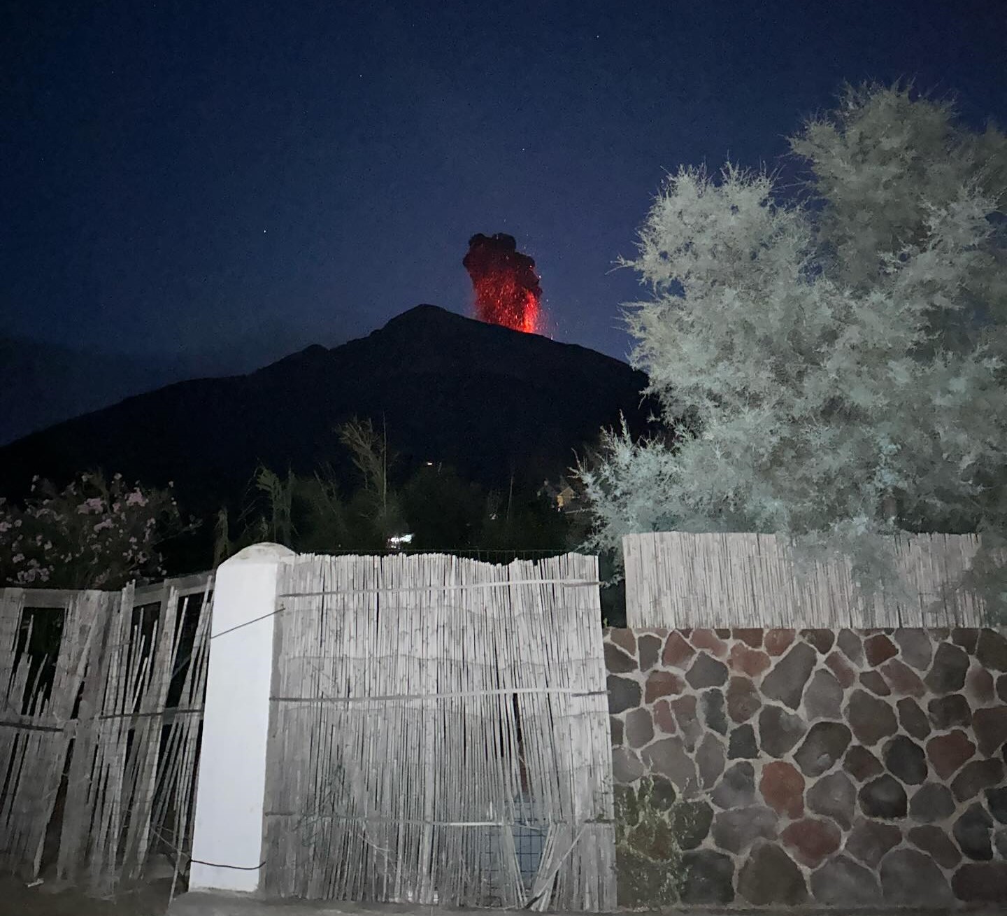
Hawaii , Kilauea :
Friday, July 26, 2024, 8:35 AM HST (Friday, July 26, 2024, 18:35 UTC)
19°25’16 » N 155°17’13 » W,
Summit Elevation 4091 ft (1247 m)
Current Volcano Alert Level: ADVISORY
Current Aviation Color Code: YELLOW
Activity Summary:
Kīlauea is not erupting. The Upper East Rift Zone unrest which began on July 22 has ended. The fourth pulse of increased seismicity was over by midday yesterday, and overall seismicity rapidly decreased afterwards and has now returned to ordinary levels. Additional seismic pulses or swarms may occur with little or no warning and result in either intrusion of magma or eruption of lava.
Summit and Upper East Rift Zone Observations:
Over the past 24 hours, there were approximately 18 earthquakes detected beneath Kīlauea’s summit, and approximately 300 earthquakes detected beneath the upper East Rift Zone (UERZ), mostly at depths of 0–4 km (0.0–2.5 mi) below the ground surface. Most of these earthquakes are associated with the fourth pulse of intense seismic activity that occurred yesterday morning, related to the UERZ intrusion which started on July 22; only approximately 60 earthquakes occurred within the last 8 hours. The fourth pulse ended by midday yesterday. Most events were smaller than magnitude-2, but there were 4 earthquakes magnitude-3 or higher in the UERZ. Tiltmeters in Kīlauea summit region (instruments SDH, southwest of the summit, and UWE, northwest of the summit) started recording inflating this morning around 3 a.m. H.S.T, suggesting magma is no longer moving into the UERZ. Field crews returned to Chain of Crater Road yesterday afternoon observed new cracks near the intrusion, and more deformation of cracks first observed on July 23. The most recent measurement of the summit’s SO2 emission rate was approximately 65 tonnes per day on July 23, 2024.
Source : HVO
Photo : USGS / N. Deligne ( archive 02/2024)
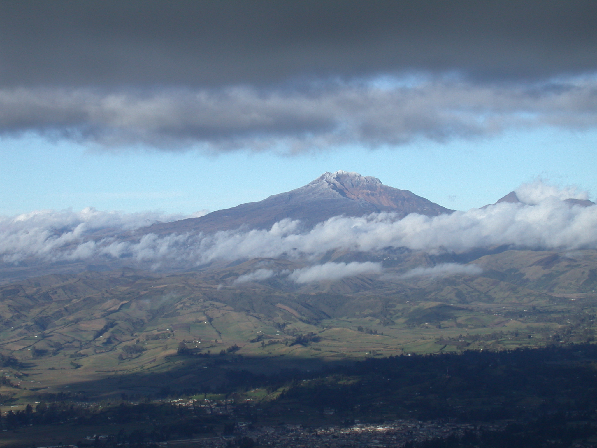
Colombia , Chiles / Cerro Negro :
San Juan de Pasto, July 23, 2024, 3:40 p.m.
Chiles and Cerro Negro Volcanoes
From monitoring the activity of the Chiles and Cerro Negro volcanoes, the Colombian Geological Service (SGC), an entity attached to the Ministry of Mines and Energy, reports that:
In the week of July 16 to 22, 2024, the activity of these volcanoes maintained unstable behavior. Compared to the previous week, the main variations in the parameters monitored were:
● In levels considered low, the seismic occurrence and the energy released increased their values.
● The predominance of seismicity associated with fracturing of cortical material remains.
● Fracture earthquakes were mainly located north of the summit of Chiles volcano, in the collapse zone, at distances less than 2 km, with depths between 3 and 5 km from the summit (4,700 m) and with a maximum magnitude of 2.7, with no reports of felt earthquakes.
● Other earthquakes were located scatteredly in the zone of influence of the two volcanoes, at distances of up to 10 km, with depths between 2 and 9 km and with a maximum magnitude of 1, 5.
● Field strain sensors and satellite sensors continue to record changes associated with inflation in the volcanic area.
Based on the above, the SGC recommends carefully monitoring developments through weekly bulletins and other information published through our official channels, as well as instructions from local and departmental authorities and the National Risk Management Unit of Disasters (UNGRD).
Volcanic activity remains on yellow alert: active volcano with changes in the behavior of the base level of monitored parameters and other manifestations.
Source et photo : SGC