July 24 , 2024.
Italy / Sicily , Etna :
Press release on the activity of Etna, July 23, 2024, 4:01 p.m. (2:01 p.m. UTC).
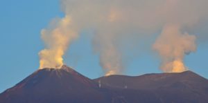
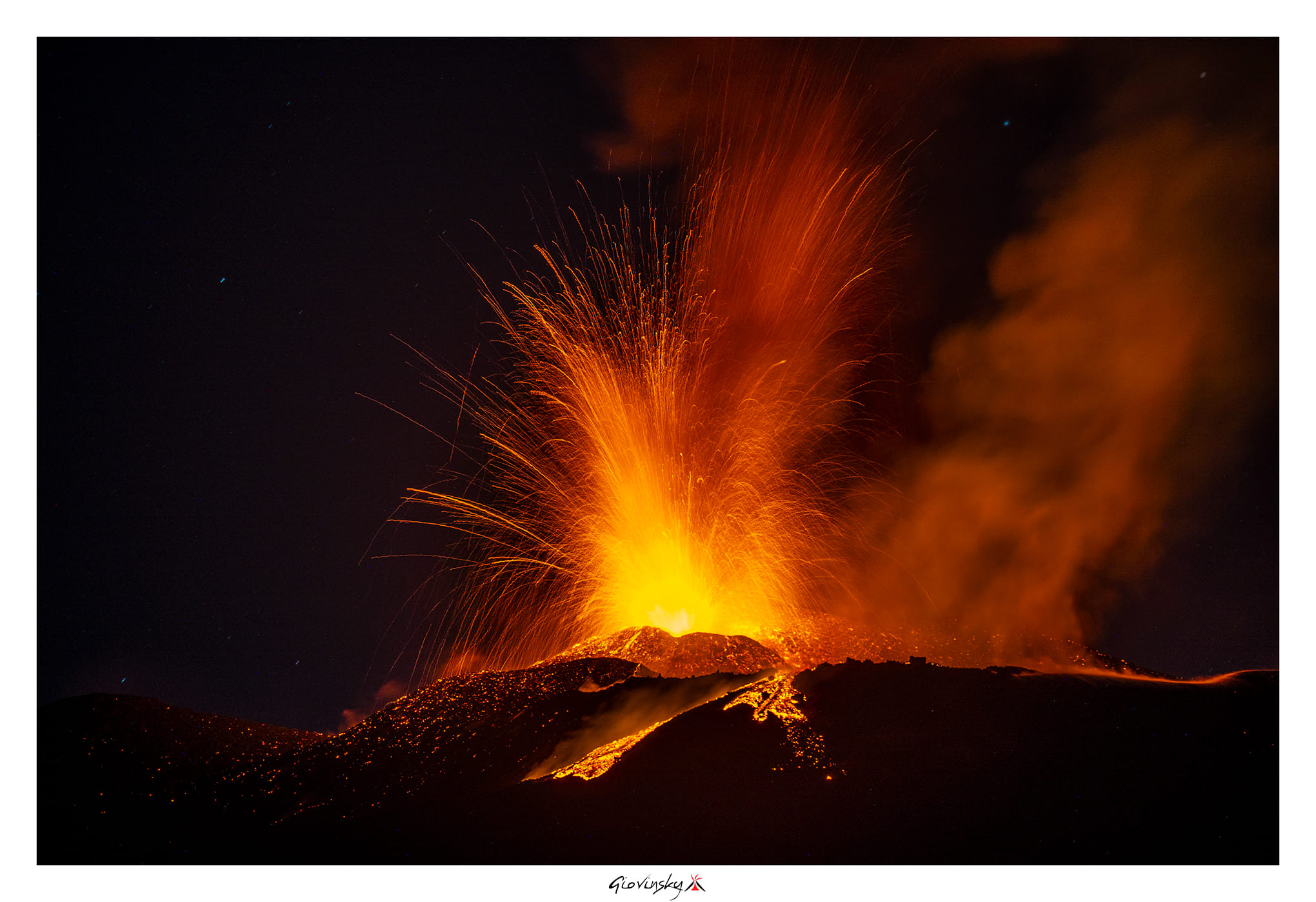
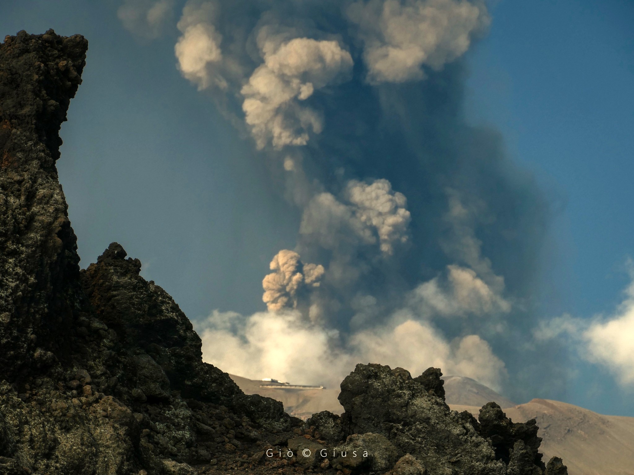
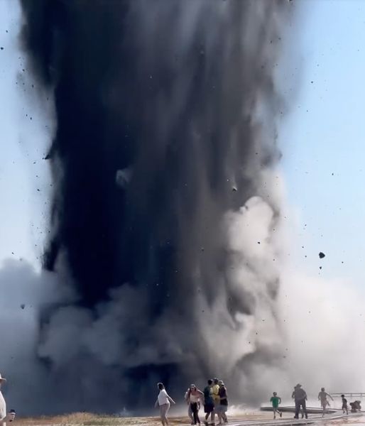
The National Institute of Geophysics and Volcanology, Osservatorio Etneo, communicates that, from the images of the video surveillance network, it can be observed that the lava fountain previously described in the press release updated at 3:08 UTC continued in the hours following. This activity produced jets of lava which, around 06:30 UTC, reached a height of several hundred meters and an eruptive column which reached a height of approximately 8 km above sea level, initially dispersing towards East-South-East, then turning towards South-South-East. Fallout of fine materials has been reported in the localities of Rifugio Sapienza, Piano Vetore, C.da Milia, Nicolosi, Tremestieri Etneo and Catania.
The activity of the fountain gradually decreased until stopping around 8:15 UTC. The activity produced a small overflow of lava from the western rim of the Bocca Nuova crater, the length of which cannot currently be estimated due to the presence of cloud cover.
From a seismic point of view, the average amplitude of the volcanic tremor reached its maximum values between 02:30 and 08:00 UTC today. Subsequently, a decrease in values was observed which, after some fluctuations, reached the base of the high level around 11:30 UTC, where they are currently maintained with a downward trend. The sources of the tremor are located in the area of the Voragine crater, at an altitude of about 2,400 m above sea level. At the same time, infrasound activity also suffered a rapid decrease, both in number of events and in amplitude. Weak infrasound activity is currently observed at the Southeast crater.
Ground deformation analyzes reveal a cumulative decompression of approximately 150 nano-strains, measured by the Monte Ruvolo dilatometer from approximately 22:00 UTC on July 22 to 7:55 UTC on July 23. In particular, the dilatometer showed progressive decompression until around 06:00 UTC, accumulating 50 nano-strains. Starting at 06:00 UTC, the signal showed a rapid change accumulating the remaining 100 nano-strains. From around 7:55 UTC, the DRUV dilatometer indicated a progressive reversal of trend, showing the beginning of a compression phase, accumulating, until the current state, a few dozen nano-strains. The inclinometer network also showed a similar trend. The largest variations are observed at the three summit stations (ECP, PDN, PLC) while some mid-altitude stations (e.g. MDZ, CBD, CIT) show minimal variations of the order of a tenth of a microradian. In particular, ECP accumulated approximately 1.0 microradians between approximately 00:00 and 06:00 UTC. From 06:00 UTC to 07:55 UTC, the ECP showed faster variations, additionally accumulating about 1.8 microradians. From around 07:55 UTC, the ECP showed, on both components, a gradual trend reversal, accumulating around 0.5 microradians. At present, ECP is beginning to record its usual performance. PDN and PLC recorded complex and fluctuating variations of less than 1 microradian.
The high-frequency processed GNSS network did not show significant variations in data variability.
Further updates will be communicated shortly
Source : INGV
Photos : Giovinsky Aetnensis , Gio Giusa.
Hawaii , Kilauea :
HVO/USGS Volcanic Activity Notice
Current Volcano Alert Level: WATCH
Previous Volcano Alert Level: ADVISORY
Current Aviation Color Code: ORANGE
Previous Aviation Color Code: YELLOW
Issued: Tuesday, July 23, 2024, 4:06 AM HST
Source: Hawaiian Volcano Observatory
Notice Number: 2024/H178
Location: N 19 deg 25 min W 155 deg 17 min
Elevation: 4091 ft (1247 m)
Area: Hawaii
Volcanic Activity Summary:
Kīlauea is not erupting. Increased earthquake activity and ground deformation at Kīlauea’s upper East Rift Zone began at approximately 3:30 a.m. HST on July 23, 2024, indicating the likely movement of magma in the subsurface. Accordingly, the USGS Hawaiian Volcano Observatory (HVO) is raising the Volcano Alert Level for ground-based hazards from ADVISORY to WATCH and the Aviation Color Code from YELLOW to ORANGE.

Map shows earthquake activity recorded along the upper East Rift Zone over the past two days
Earthquake activity is centered near Pauahi Crater. The situation is rapidly evolving, and, at this time, it is not possible to say with certainty if this activity will lead to an eruption; the activity may remain below ground. An eruption in Kīlauea’s upper East Rift Zone within Hawai‘i Volcanoes National Park is one potential outcome. It is not possible to say where such an outbreak may occur, but the area between Hiʻiaka crater and Maunaulu in Hawai‘i Volcanoes National Park, is potentially at risk for a new lava outbreak based on past patterns of eruptive activity in this area. Past eruptions in this region of Kīlauea’s upper East Rift Zone, between Hiʻiaka crater and Maunaulu, occurred over hours to about a month. The location of any future outbreak will determine what areas could be in the path of new lava flows.
Tuesday, July 23, 2024, 9:43 AM HST (Tuesday, July 23, 2024, 19:43 UTC)
Current Volcano Alert Level: ADVISORY
Current Aviation Color Code: YELLOW
Activity Summary:
Kīlauea is not erupting. Localized earthquake and ground deformation rates in Kīlauea’s upper East Rift Zone increased significantly twice in the past 24 hours, prompting a Status Report and brief alert level change. As of this morning, seismicity and ground deformation rates have decreased but remain elevated. The pulsing nature of this activity may represent stages in intrusive activity beneath the upper East Rift Zone region. Additional seismic pulses or swarms may occur with little or no warning and result in either continued intrusion of magma or eruption of lava.
HVO continues to closely monitor Kīlauea. Should volcanic activity change significantly, a new Volcanic Activity Notice will be issued.
Source : HVO
Italy , Stromboli :
WEEKLY BULLETIN, from July 15, 2024 to July 21, 2024. (issue date July 23, 2024)
SUMMARY STATEMENT OF ACTIVITY
In light of the monitoring data, it appears:
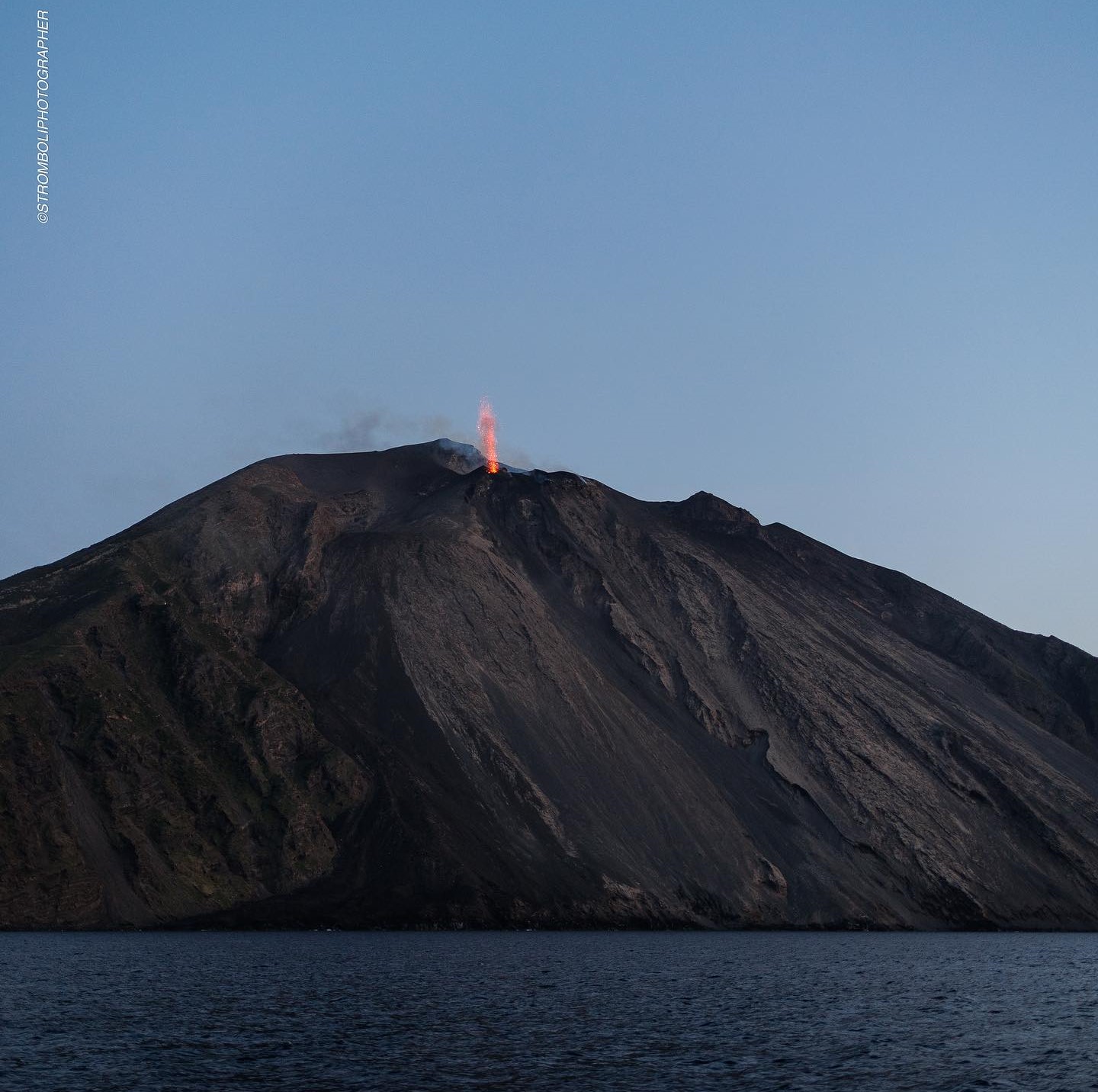
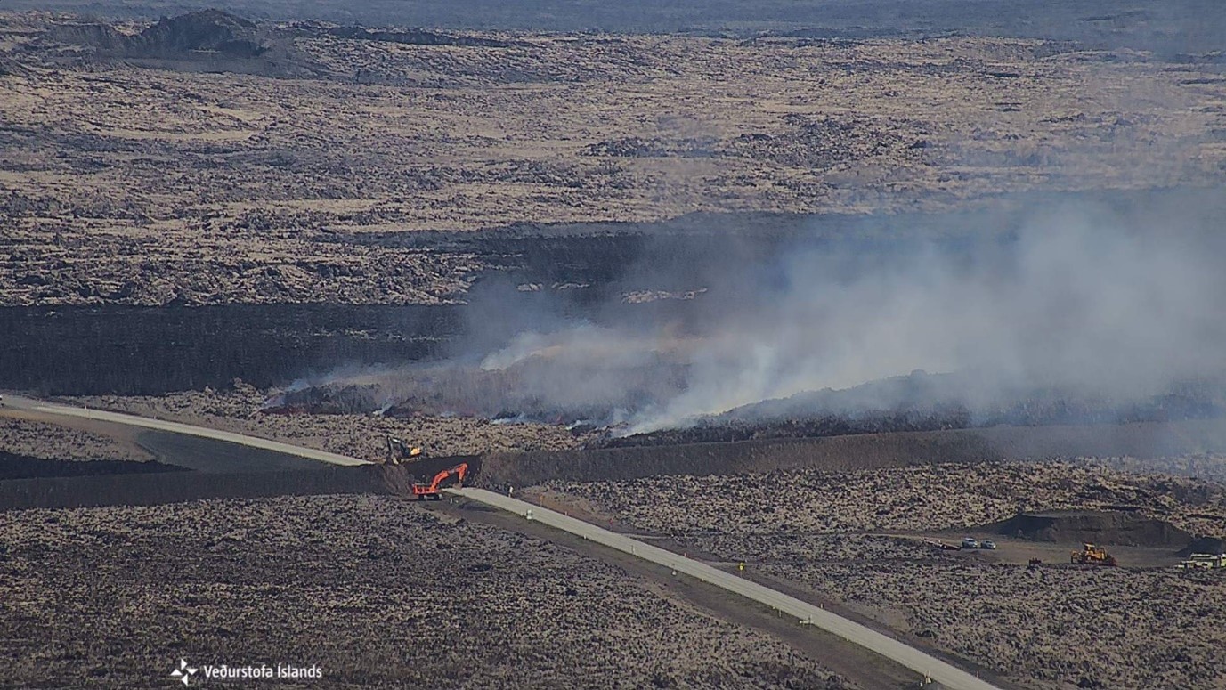
1) VOLCANOLOGICAL OBSERVATIONS: Conclusion of effusive activity on July 11 and episodic ordinary explosive activity from July 17.
2) SISMOLOGY: The monitored seismological parameters do not show significant variations.
3) GROUND DEFORMATIONS: Contraction trend of the STDF-SVIN distance. There is no variation in the trend of the radial component of TDF inclination.
4) GEOCHEMISTRY: SO2 flux at medium level
CO2 flow from the ground to the Pizzo (STR02): due to technical problems there are no updates.
The isotopic ratio of dissolved Helium in the wells shows high values.
The C/S ratio is at average values.
CO2 flow in Mofeta in the San Bartolo area: slightly decreasing, but still remaining at high values.
CO2 flux in Scari: stable values at medium-high levels.
5) SATELLITE OBSERVATIONS: Thermal activity observed by satellite was generally low level with some isolated thermal anomalies of moderate level.
VOLCANOLOGICAL OBSERVATIONS
During the week, the activity of Stromboli was observed thanks to INGV surveillance cameras and through different inspections and data acquisitions in the field and via drones by INGV staff. As reported in the weekly Rep. newsletter. N. 29/2024 STROMBOLI, in the period following the paroxysmal explosion of July 11, the interruption of the effusive activity and the continued absence of the ordinary explosive activity which ceased on July 4 were observed. From July 14, rare impulsive episodes were observed with ash emission without thermal anomalies and associated with degassing. On July 17, 20 and 22, the characteristics of these explosions changed and 3 ordinary category explosive episodes were recorded in the North zone and one in the Center-South zone.
Source : INGV
Photo : Stromboli stati d’animo / SebastianO Cannavo.
United – States , Yellowstone :
Tuesday, July 23, 2024, 1:24 PM MDT (Tuesday, July 23, 2024, 19:24 UTC)
44°25’48 » N 110°40’12 » W,
Summit Elevation 9203 ft (2805 m)
Current Volcano Alert Level: NORMAL
Current Aviation Color Code: GREEN
At around 10:00 AM MST on July 23, 2024, a small hydrothermal explosion occurred in Yellowstone National Park in the Biscuit Basin thermal area, about 2.1 miles (3.5 km) northwest of Old Faithful. Numerous videos of the event were recorded by visitors. The boardwalk was damaged, but there were no reports of injury. The explosion appears to have originated near Black Diamond Pool.
Biscuit Basin, including the parking lot and boardwalks, are temporary closed for visitor safety. The Grand Loop road remains open. Yellowstone National Park geologists are investigating the event.
Hydrothermal explosions occur when water suddenly flashes to steam underground, and they are relatively common in Yellowstone. For example, Porkchop Geyser, in Norris Geyser Basin, experienced an explosion in 1989, and a small event in Norris Geyser Basin was recorded by monitoring equipment on April 15, 2024. An explosion similar to that of today also occurred in Biscuit Basin on May 17, 2009.
Monitoring data show no changes in the Yellowstone region. Today’s explosion does not reflect activity within volcanic system, which remains at normal background levels of activity. Hydrothermal explosions like that of today are not a sign of impending volcanic eruptions, and they are not caused by magma rising towards the surface.
Additional information will be provided as it becomes available.
Source : YVO
Photo : Vlada March ( 23/07/2024)
Iceland , Reykjanes Peninsula :
Magma accumulation under the Svartsengi region continues at a steady rate
Increased likelihood of a new dike intrusion and an eruption in the coming weeks. Updated scenarios released alongside a revised hazard assessment.
Updated 23 July at 18:00
Based on the volume loss observed during diking on 29 May, and continued subsidence during the first week of the May-June eruption, it is estimated that a volume between 13 to 19 million cubic meters needs to be recharged before the next event is triggered
According to model calculations, the total recharge volume is likely to approach 16 million cubic meters in the coming days
A new magma intrusion and an eruption is considered highly probable within the next two to three weeks
Hazard map have been updated
In recent days, seismicity in the Sundhnúks crater row has been relatively low, although slowly increasing. Ten micro-earthquakes have been detected in the crater row in the last 24 hours, and about 90 in the past week. Most of the earthquakes are below magnitude one and are distributed along the crater row. By comparison, over 50 earthquakes were recorded daily in the lead-up to the last eruption. Over the past few weeks, seismic activity is slowly increasing day by day, in line with the continued accumulation of magma within the Svartsengi reservoir.
There is some uncertainty in these calculations, but a new magma intrusion and an eruption is considered highly probable within the next two to three weeks, provided the magma inflow rate to the Svartsengi reservoir remains stable.
« All our geodetic measurements and modelling results indicate that magma accumulation under Svartsengi is continuing at a steady pace, » says Michelle Maree Parks, a volcano deformation expert at the Icelandic Meteorological Office. « It is not unusual to see fluctuations in uplift between daily measurements. It is important to look at the overall picture based on both vertical and horizontal GNSS measurements, satellite images, and models spanning a longer period. In recent weeks, there are no indications in our data or models that suggest any significant changes to magma inflow to the Svartsengi reservoir. Provided the inflow rate remains stable we can expect a new dike intrusion and an eruption in the next two to three weeks, » says Michelle.
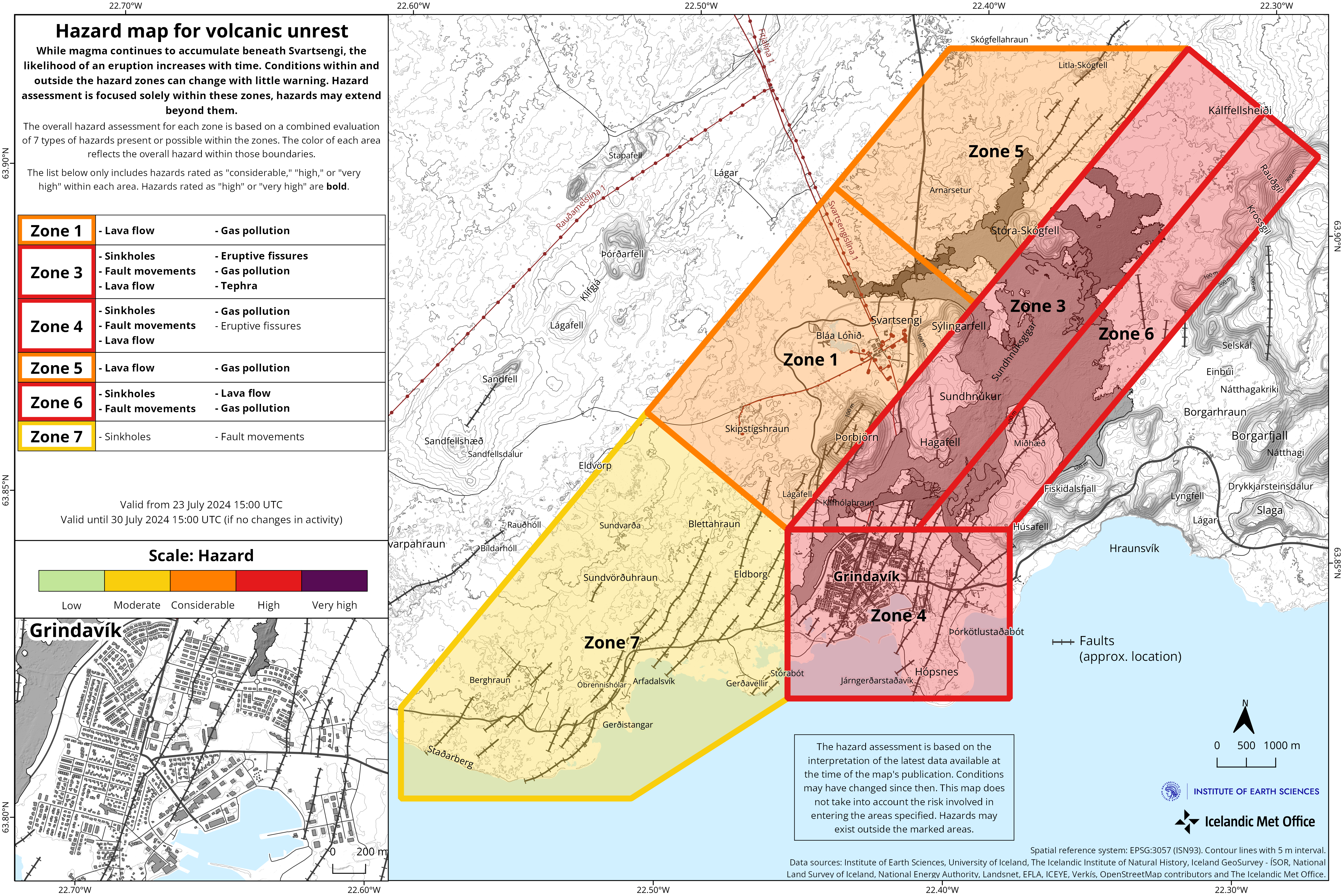
Updated hazard assessment
The Icelandic Meteorological Office has updated the hazard assessment considering the likelihood of a new magma intrusion and an eruption in the coming weeks. The hazard level has been raised in all areas except in zone 7. The hazard assessment is valid until 30 July, unless conditions change.
Source : IMO
Photos : IMO (06/2024) , IMO.