July 6 , 2024.
Italy , Stromboli :
Press release on Stromboli activity, July 5, 2024, 10:59 (08:59 UTC).
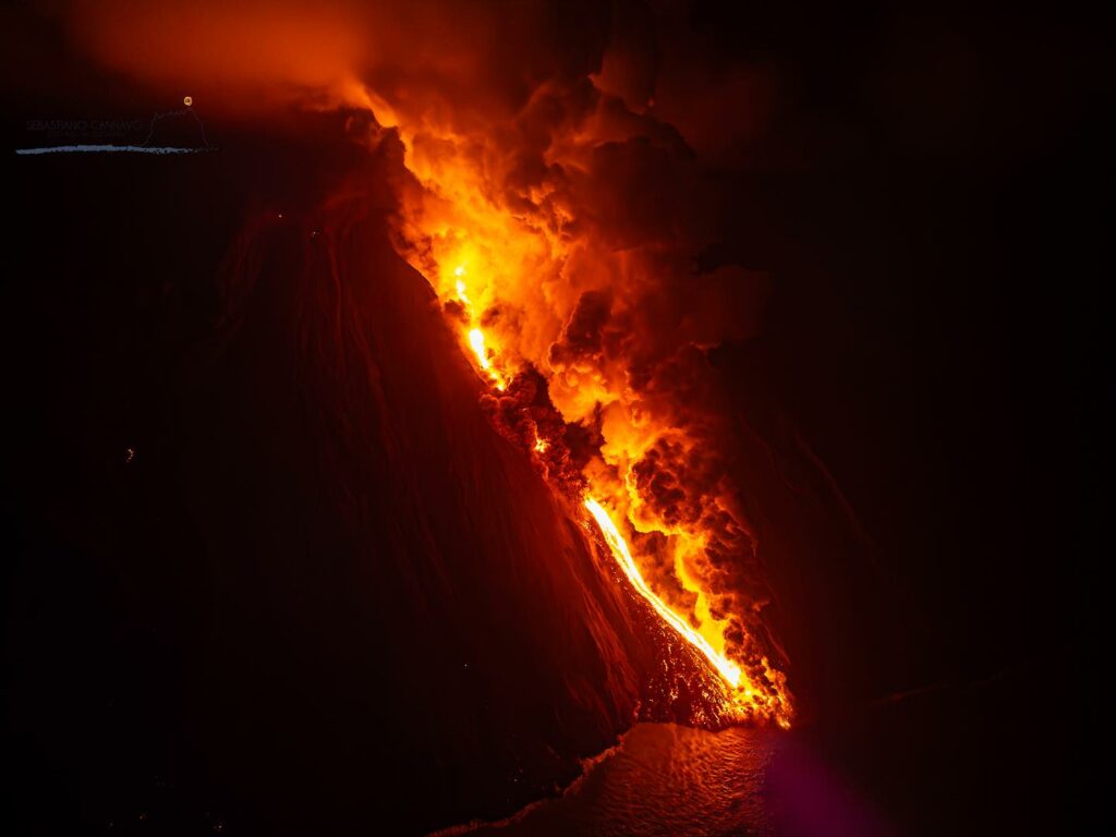
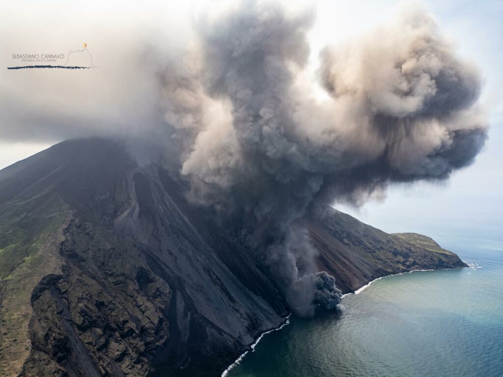
The National Institute of Geophysics and Volcanology, Osservatorio Etneo, communicates that from the analysis of the images from the cameras of the video surveillance network and the INGV staff in the field, we observe that a lava flow emitted by a vent approximately 600 m is currently active above sea level, reaching the coastline causing a cloud of steam and ash to form. The phenomenon produces episodic low-energy pyroclastic flows and rolling materials that propagate along the Sciara del Fuoco, quickly reaching the sea.
The average amplitude of the volcanic tremor remained at high or very high values until about 01:00 UTC, then moved, with some oscillations, into the average value range around 04:00 UTC, where it is currently.
Ground deformation monitoring networks showed higher noise at the Timpone del Fuoco Inclinometer (TDF) between 4:20 p.m. UTC and 6:20 p.m. UTC on July 4, coinciding with the highest amplitude phase of the volcanic tremor, therefore potentially attributable to vibrations induced on the inclinometer sensor. .
After this phase, the sensor shows general stability of the signal and does not indicate the deformations that occurred during the last hours. Even the stations of the high frequency GNSS network, having overcome the phase of disturbance probably linked to volcanic ash, do not show significant variations.
Press release on Stromboli activity, July 5, 2024, 1:21 p.m. (11:21 UTC).
The National Institute of Geophysics and Volcanology, Osservatorio Etneo, communicates that, thanks to surveillance cameras, it was possible to observe a sequence of pyroclastic flows at 10:19 a.m.; 10:27 a.m.; 10:30 a.m.; and 10:33 UTC which, propagating along the Sciara del Fuoco, quickly reached the sea. The lava flow emitted by a vent at 510 m altitude remained well fed, reaching the coast, producing the formation of a cloud of steam and ashes. The average amplitude of the seismic signal, since the last press release, has remained at an average value with the appearance of a peak at high values at 10:20 UTC. The latter, as revealed by the analysis of the seismograms, is linked to the amplitude transients of the seismic signal generated by the pyroclastic flows along the Sciara del Fuoco. Subsequently, the amplitude of the seismic signal returned to average values.
Analysis of inclinometer and GNSS data shows no significant change over the past few hours.
Press release on Stromboli activity, July 5, 2024, 10:28 p.m. (8:28 p.m. UTC).
The National Institute of Geophysics and Volcanology, Osservatorio Etneo, communicates that from the analysis of the cameras of the surveillance network and the INGV personnel in the field, a resumption of effusive activity was observed on the Sciara del Fuoco from 18:55 UTC. The average amplitude of the seismic signal, after what was reported in the last press release, continued to show a downward trend and has currently reached values that are at a low level. Analysis of seismograms highlights a very low level of activity and no evidence of an explosion earthquake. The analysis of ground deformation data does not highlight significant changes at the monitoring network stations.
Further updates will be communicated shortly.
Source : INGV.
Photos : Stromboli stati d’animo / Sebastiano Cannavo.
Iceland , Reykjanes Peninsula :
No recent reduction in magma inflow rate into the Svartsengi reservoir
Magma inflow continues into the Svartsengi reservoir and the likely timeframe for the next diking event and/or eruption is the coming weeks/months
Updated 5. July at 17:15 UTC
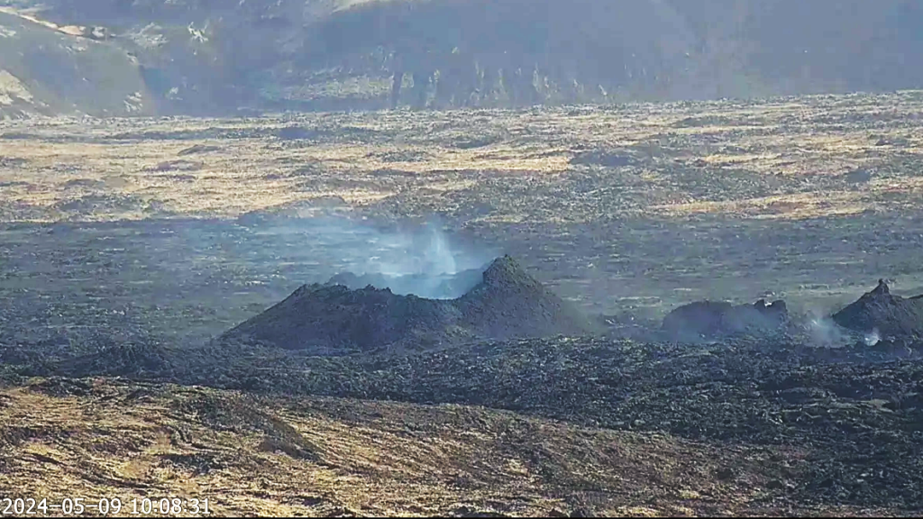
Since the end of the eruption in Sundhnúks crater row on 22 June, the level of seismicity in the Svartsengi region is still very low with only a few small earthquakes detected daily.
.
Ground deformation data show that the uplift in the region continues. This is interpreted as continued magma inflow into the Svartsengi reservoir.
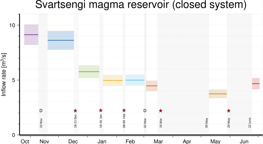
Geodetic modelling has been used to estimate the magma inflow rate into the Svartsengi reservoir during periods with no eruptions. In these periods the system is considered “closed” and, as such, the analysis does not account for additional magma inflow that occurs when the system is open during eruptive periods (e.g. the volume of magma that flows through the system and is extruded as lava during eruptions). Therefore, the graph does not reflect the total inflow into the system since November 2023, but only the inflow feeding the reservoir when the system is closed.
The graph shows the estimated inflow rate of magma into the Svartsengi reservoir during periods with no eruptions. The grey areas correspond to eruptive periods or diking events. The model calculates magma inflow rate for those periods outside the grey areas (colored horizontal lines). The red line with associated uncertainty (red area) corresponds to the current estimate of magma inflow rate. The letter D stands for Dike intrusion and the star for eruption.
Data shows inflow rates between 8 and 10 m3/s until the first eruption in December 2023. Following this, the model indicates that the magma inflow rate at depth has typically been in the region of 4 to 6 m3/s, when accounting for the uncertainties in the results. Considering the uncertainty in the model, the inflow rates since mid-January have been relatively stable. As of today, the inflow rate is assessed to be in line with what has been observed since mid-January with no evidence of a declining trend. Combined analysis of erupted volumes and volume changes within the Svartsengi volcanic system indicates that the overall magma availability is in fact higher.
Source : IMO
Photos : RÚV – Webcam à Orbirn , IMO.
Alaska , Cleveland :
AVO/USGS Volcanic Activity Notice
Current Volcano Alert Level: ADVISORY
Previous Volcano Alert Level: NORMAL
Current Aviation Color Code: YELLOW
Previous Aviation Color Code: GREEN
Issued: Friday, July 5, 2024, 2:54 PM AKDT
Source: Alaska Volcano Observatory
Notice Number: 2024/A507
Location: N 52 deg 49 min W 169 deg 56 min
Elevation: 5676 ft (1730 m)
Area: Aleutians
Volcanic Activity Summary:
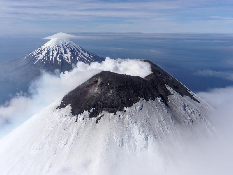
Sulfur dioxide gas emissions were detected on local gas monitoring sensors at Mount Cleveland starting June 21 with an increase in emission rate June 24–30. Although sulfur dioxide emissions declined to background levels on July 1, moderately elevated surface temperatures and vigorous steaming at the summit of the volcano observed over the past couple of days, suggest that Cleveland is in a state of volcanic unrest prompting the Alaska Volcano Observatory to upgrade the aviation Color Code to YELLOW and Volcano Alert Level to ADVISORY.
The last eruptive activity at Mount Cleveland was a short-lived explosion during the evening (local time) of June 1, 2020. Despite the current pause, the eruptive period at Mount Cleveland, dating back to 2001, remains ongoing and future explosions are likely. These have occurred without warning and typically generate small clouds of volcanic ash that are a hazard in the immediate vicinity of the volcano, though more significant ash emissions are possible.
Mount Cleveland is currently monitored with a five-station real-time seismic network. Based on past events, explosive eruptions of Cleveland may occur with little or no warning. Rapid detection of an ash-producing eruption may be possible using a combination of seismic, infrasound, lightning, and satellite data.
Recent Observations:
[Other volcanic cloud information] Sulfur dioxide gas emissions detected on local gas monitoring sensors.
Hazard Analysis:
[Volcanic gas] Sulfur dioxide gas emissions detected on local gas monitoring sensors.
Remarks:
Cleveland volcano forms the western portion of Chuginadak Island, a remote and uninhabited island in the east central Aleutians. The volcano is located about 45 miles (75 km) west of the community of Nikolski, and 940 miles (1500 km) southwest of Anchorage. The most recent significant period of eruption began in February 2001 and produced 3 explosive events that generated ash clouds as high as 39,000 ft (11.8 km) above sea level. The 2001 eruption also produced a lava flow and hot avalanche that reached the sea. Since then, Cleveland has been intermittently active producing small lava flows, often followed by explosions that generate small ash clouds generally below 20,000 ft (6 km) above sea level. These explosions also launch debris onto the slopes of the cone producing hot pyroclastic avalanches and lahars that sometimes reach the coastline.
Source : AVO
Photo : Herstand, Malcolm / Alaska Volcano Observatory / Alaska Division of Geological & Geophysical Surveys
Indonesia , Lewotobi Laki-laki :
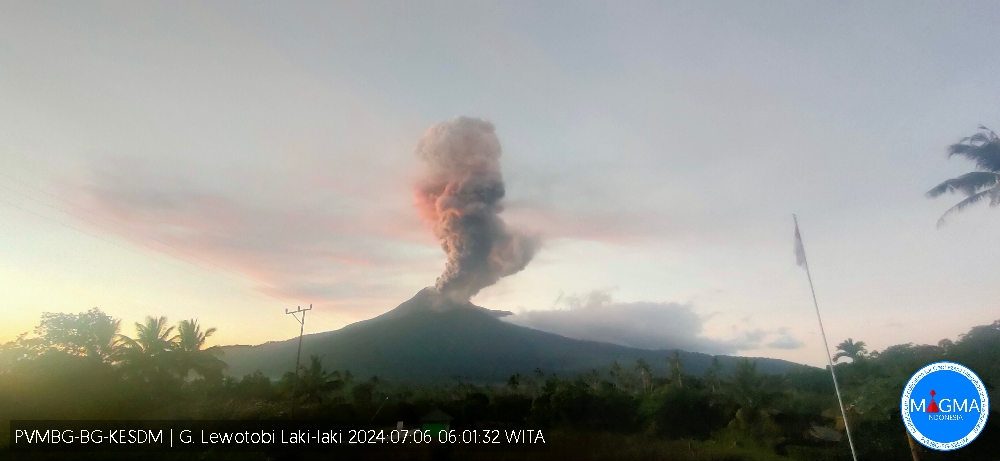
An eruption of Lewotobi Laki-Laki occurred on Saturday July 6, 2024 at 05:55 WITA with the height of the ash column observed at ± 900 m above the summit (± 2484 m above sea level) . The ash column was observed to be gray with thick intensity oriented towards the West. This eruption was recorded on a seismograph with a maximum amplitude of 47.3 mm and a duration of 313 seconds.
VOLCANO OBSERVATORY NOTICE FOR AVIATION – VONA
Issued : July 05 , 2024
Volcano : Lewotobi Laki-laki (264180)
Current Aviation Colour Code : ORANGE
Previous Aviation Colour Code : orange
Source : Lewotobi Laki-laki Volcano Observatory
Notice Number : 2024LWK172
Volcano Location : S 08 deg 32 min 20 sec E 122 deg 46 min 06 sec
Area : East Nusa Tenggara, Indonesia
Summit Elevation : 5069 FT (1584 M)
Volcanic Activity Summary :
Eruption with volcanic ash cloud at 21h55 UTC (05h55 local).
Volcanic Cloud Height :
Best estimate of ash-cloud top is around 7949 FT (2484 M) above sea level or 2880 FT (900 M) above summit. May be higher than what can be observed clearly. Source of height data: ground observer.
Other Volcanic Cloud Information :
Ash cloud moving to west. Volcanic ash is observed to be gray. The intensity of volcanic ash is observed to be thick.
Remarks :
Eruption recorded on seismogram with maximum amplitude 47.3 mm and maximum duration 313 second.
Source et photo : Magma Indonésie.
Colombia , Puracé :
Popayan, July 5, 2024, 7:00 a.m.
Regarding the monitoring of the activity of the PURACE VOLCANO – LOS COCONUCOS VOLCANIC RANGE, the COLOMBIAN GEOLOGICAL SERVICE (SGC), an entity attached to the MINISTRY OF MINES AND ENERGY, reports that:
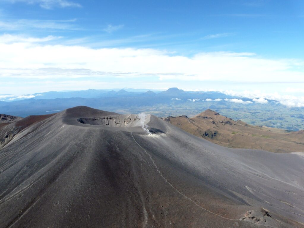
The alert status of the Puracé volcano changes to YELLOW: ACTIVE VOLCANO WITH CHANGES IN THE BEHAVIOR OF THE BASIC LEVEL OF MONITORED PARAMETERS AND OTHER MANIFESTATIONS.
Over the past few weeks, the volcano’s activity has shown a gradual decrease in several of the monitored parameters following the increase that led to the alert status change from Yellow to Orange on May 3. Since the behavior of the volcano has shown a trend towards stabilization, the SGC determines that the Puracé volcano – Los Coconucos Volcanic Range is moving from Orange to Yellow alert status.
This change is based on the results of the observation, analysis and overall evaluation of the parameters permanently monitored on the volcano, which include the following:
● A progressive decrease in seismicity within the volcanic structure. After reaching the highest daily rates in the number of earthquakes since instrumental monitoring was available, between May 30 and June 6, 2024, seismicity has returned in recent weeks to levels similar to those before the May 24. Furthermore, the magnitudes obtained are less than 1 ML (local magnitude), which reflects low values of released energy.
● Seismicity associated with the ascent or placement of magma in the surface portion of the volcano has not been recorded again, which may indicate that magma that may have previously moved is currently stable.
● The outgassing processes of sulfur dioxide (SO2) into the atmosphere have shown a downward trend in recent weeks.
● Volcanic surface deformation continues to exhibit rates similar to those recorded before the change in alert status.
It is important to clarify that, although the alert state changes to Yellow, the Puracé volcano – Los Coconucos Volcanic Range is still unstable and could quickly destabilize, which would lead to a return to the Orange alert state or even Red, and it is necessary for the community in general to be attentive to the evolution of volcanic activity.
Source et photo : SGC

