16 Mai 2024.
Alaska , Spurr :
The Alaska Volcano Observatory (AVO) has detected a small increase in volcano seismic activity at Mount Spurr, which may indicate an intrusion of new magma deep beneath the volcano. An extended recent outage of the local seismic network from February to April 2024 limits precise determination of the onset of this activity, but elevated seismicity has been seen since the network returned on April 3. Since then, AVO has located an average of four earthquakes per day, with a peak of 33 recorded on April 26. These have typically been smaller than magnitude 1.0, and range in depth from near the summit of the volcano to as much as 18 miles (30 km) below sea level. This activity represents an increase in earthquake rate and occurrence of deeper (>12.4 miles or 20 km) low frequency earthquakes compared to recent years. These low frequency earthquakes are likely related to the migration of fluids. Minor uplift of the ground surface at the volcano of ~0.4 inches (~1 cm) has also been observed in local GPS data since November 2023, which is a deviation from the long-term trend and may be related to the seismicity. No significant changes to the ice and snow cover or gas and steam emissions have been observed in association with these geophysical observations. In clear viewing conditions, minor steaming is commonly visible from fumaroles in the summit crater region.
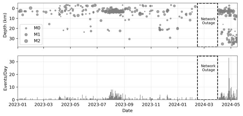
Earthquakes located under Mount Spurr, Alaska from January 1, 2023 to May 14, 2024. The top panel shows earthquake depths through time and the bottom panel shows earthquakes per day. The size of the circles in the top panel reflects the magnitude of the earthquakes as shown in the legend. An increase in the amount and occurrence of deep low frequency earthquakes began in April 2024. A seismic network outage in early 2024 limited AVO’s ability to locate earthquakes. The increase in earthquakes in summer 2023 is related to nearby glaciers and not associated with volcanic activity.
Mount Spurr is monitored by an eleven-station seismic network, four continuous GPS receivers, four infrasound sensors, and web cameras. Data from five of the eleven stations are currently coming into AVO in real time, but the other six stations in the network are only recording data locally. AVO plans to restore real-time feeds from those stations and recover the stored data during maintenance visits this summer, beginning on May 20, 2024. Additional regional seismic stations and infrasound sensors located throughout south-central Alaska provide supporting data. AVO also monitors the volcano using satellite monitoring, lightning data, pilot reports, and airborne and ground observations to detect changes in the snow and ice surfaces, thermal emissions, and volcanic ash, steam, and gas emissions. AVO conducted a short observational overflight on May 14, 2024, and another to measure gas emissions and make observations is planned for June.
The activity that we have observed at Mount Spurr over the past six weeks is consistent with the intrusion of magma deep beneath the volcano. Such an intrusion can cause subtle inflation or swelling of the volcano and generate earthquakes through the release magmatic gasses.
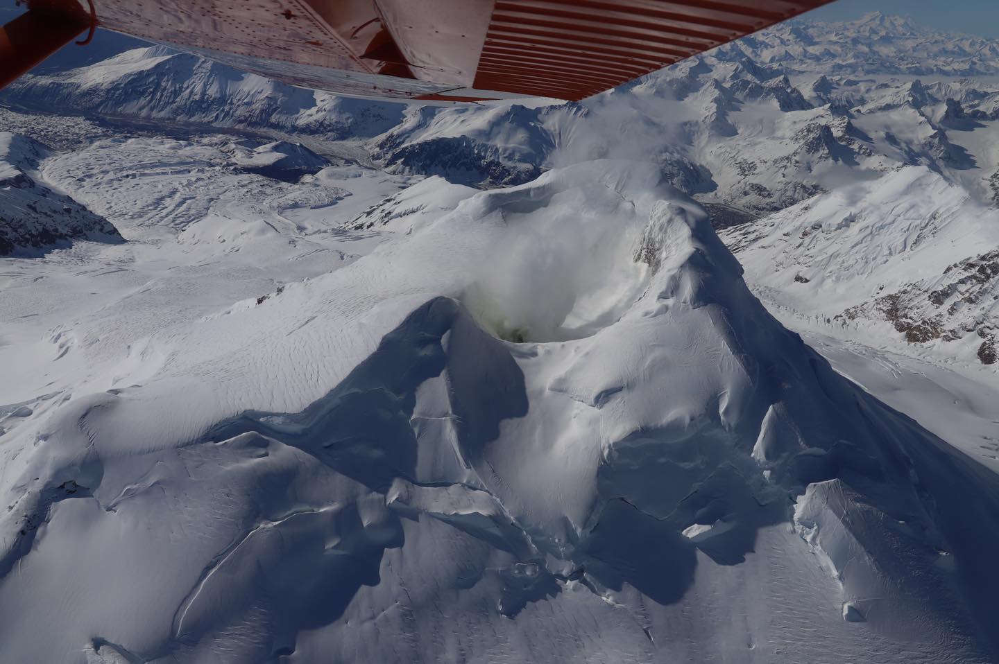
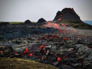
Steaming from the summit crater at Mount Spurr is visible during an overflight on May 14, 2024. The steam source is a fumarole (steam vent) inside of the summit crater, which is snow-free and yellowish, due to sulfur precipitating from the plume. Photograph is taken looking toward the south.
While these observations suggest that increased activity may be occurring deep beneath Mount Spurr, there is no indication that an eruption may occur soon, if at all. Intrusions of new magma under volcanoes do not always result in volcanic eruptions and activity may decline without an eruption occurring, such as during the previous intrusion under Mount Spurr that occurred in 2004. Prior to a significant eruption, AVO would expect months of volcanic unrest that would allow advanced warning. This would likely consist of a greater increase and shallowing of earthquakes, increased uplift of the ground surface as magma rises to shallower levels in the Earth’s crust, and signs of increased heat and magmatic gas emissions, such as localized melting of summit glaciers and debris flows.
If Mount Spurr were to erupt, the primary hazard would be airborne ash and ashfall on down-wind communities. The slopes of the volcano would also be affected by pyroclastic flows, and lahars, or mudflows formed from the melting of ice and snow due to volcanic activity, could inundate drainages on all sides of the volcano, particularly on the south and east flanks.
Source : AVO
Photos : AVO , Haney Matthew / AVO/USGS.
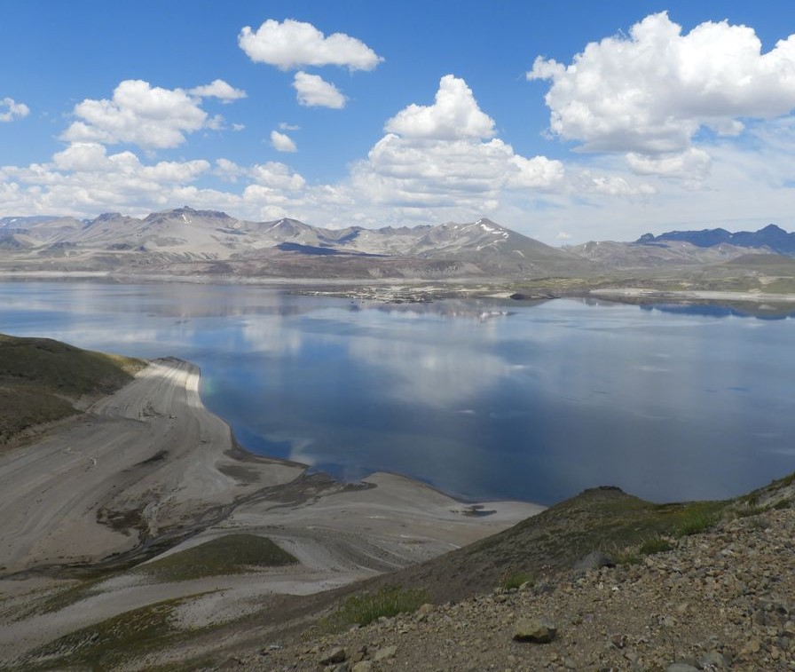
Chile , Laguna del Maule :
Special Report on Volcanic Activity (REAV), del Maule regions, Laguna del Maule volcanic complex, May 15, 2024, 10:45 a.m. local time (mainland Chile)
The National Geology and Mining Service of Chile (Sernageomin) announces the following PRELIMINARY information, obtained through the monitoring equipment of the National Volcanic Monitoring Network (RNVV), processed and analyzed at the Southern Andean Volcano Observatory (Ovdas):
On Wednesday May 15, 2024, at 10:45 a.m. local time (2:45 p.m. UTC), monitoring stations installed near the Laguna del Maule volcanic complex recorded a seismic swarm associated with the fracturing of rocks (volcano-tectonic). At the time of issuing this report, more than 100 events have been recorded.
The characteristics of the largest earthquake after its analysis are as follows:
ORIGINAL TIME: 10:15 a.m. local time (2:15 a.m. UTC)
LATITUDE: 36.086° S
LONGITUDE: 70.488°E
DEPTH: 4.2 km
LOCAL MAGNITUDE: 1.7 (ML)
Observation :
At the time of issuing this report, we continue to record volcano-tectonic seismicity but of lower energy (low to moderate).
The technical volcanic alert is maintained at YELLOW level.
Seismology
The seismological activity of the period was characterized by the recording of:
338 seismic events of type VT, associated with the fracturing of rocks (Volcano-Tectonics). The most energetic earthquakes had a Local Magnitude (ML) value, both equal to 1.4 located 3.8 km South-South-East of the center of the lagoon and an average depth of 7.5 km.
Fluid Geochemistry
No anomalies have been reported in the emissions of sulfur dioxide (SO2) into the atmosphere in the area near the volcanic complex, according to data published by the Tropospheric Monitoring Instrument (TROPOMI) and the Ozone Monitoring Instrument (OMI) Sulfur Dioxide Group.

Geodesy
The geodetic activity of the period was characterized by:
-Changes in magnitudes in the horizontal and vertical components, highlighting the vertical components of all stations which are decreasing their magnitudes.
-Changes in line lengths, where magnitudes also decrease, but trend direction is maintained.
-Analysis with the InSAR technique shows a loss of coherence due to snowfall in the area.
The changes observed during the period are attributed to adverse meteorological processes that affect the instrumental response of the stations; however, inflation continues, but with a decrease in the magnitude of the deformation;
Surveillance cameras
The images provided by the fixed camera, installed near the volcanic complex, did not record degassing columns or variations linked to surface activity.
Activity remained at levels considered low, suggesting stability of the volcanic complex. The technical volcanic alert is maintained in:
YELLOW TECHNICAL ALERT: Changes in the behavior of volcanic activity
Source : Sernageomin
Photos : Sernageomin , RudiR/ commons.wikimedia.org .
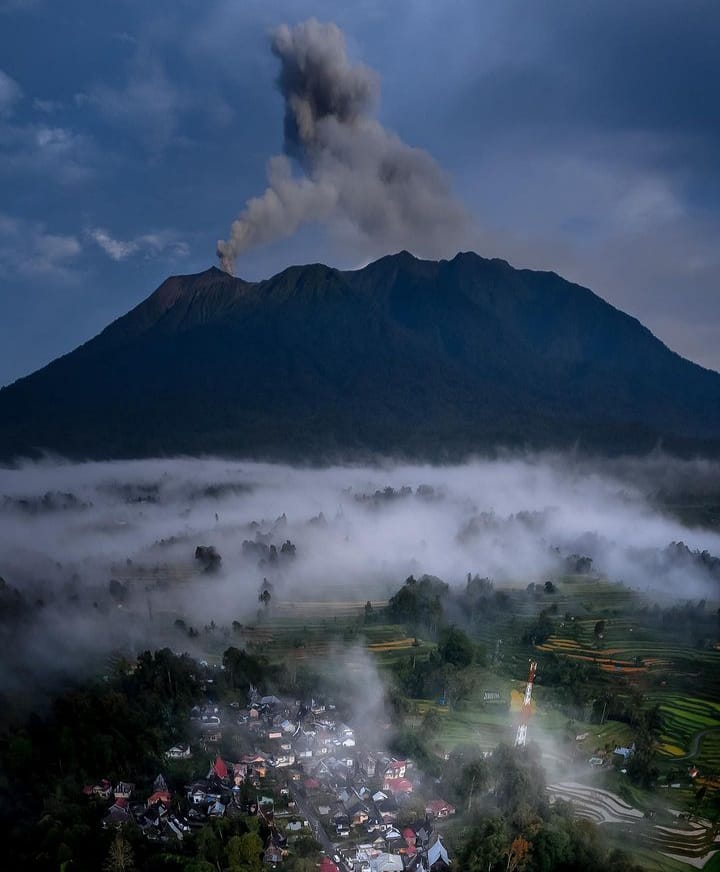
Indonesia , Marapi :
PVMBG reported that unrest at Marapi (on Sumatra) was ongoing during 8-14 May. White gas-and-steam plumes rose 200-300 m above the summit and drifted in multiple directions on most days; no emissions were visible on 10 May. An eruptive event was recorded on 10 May, though plumes were not visible.
Lahars generated by intense rainfall occurred around 2100 on 11 May and caused several fatalities, evacuations, and widespread damage in the Agam Regency. The lahars originated in the Malana or Lona drainage on Marapi’s flank and significantly impacted several areas including in the Agam, Tanah Datar, Padang Panjang, and Padang Pariaman districts. Aid efforts were delayed by damage to bridges and several sections of roads between villages.
Close to 200 homes were damaged or missing, around 72 hectares of fields were affected, and mosques were damaged. Search-and-rescue efforts were suspended overnight during 11-12 May due to lack of light and continuing flooding in upstream areas. As of 1300 on 13 May there were 15 people that remained missing. The number of evacuees totaled 1,159 in the Agam Regency and 2,039 in the Tanah Datar Regency. Accordion to a news report the death toll reached 43 people on 15 May. The Alert Level remained at 3 (on a scale of 1-4), and the public was warned to stay 4.5 km away from the active crater
Seismicity observation:
4 emission earthquakes with an amplitude of 1.6 to 6.1 mm and earthquake duration of 10 to 18 seconds.
1 Distant tectonic earthquake with an amplitude of 3.1 mm, and duration of the earthquake of 62 seconds.
1 Continuous tremor with an amplitude of 0.5 to 2 mm, dominant value of 0.5 mm.
Sources : Pusat Vulkanologi et Mitigasi Bencana Geologi (PVMBG), Badan Nacional Penanggulangan Bencana (BNPB), Antara News, GVP.
Photo : Sumatera Barat Indonesia.
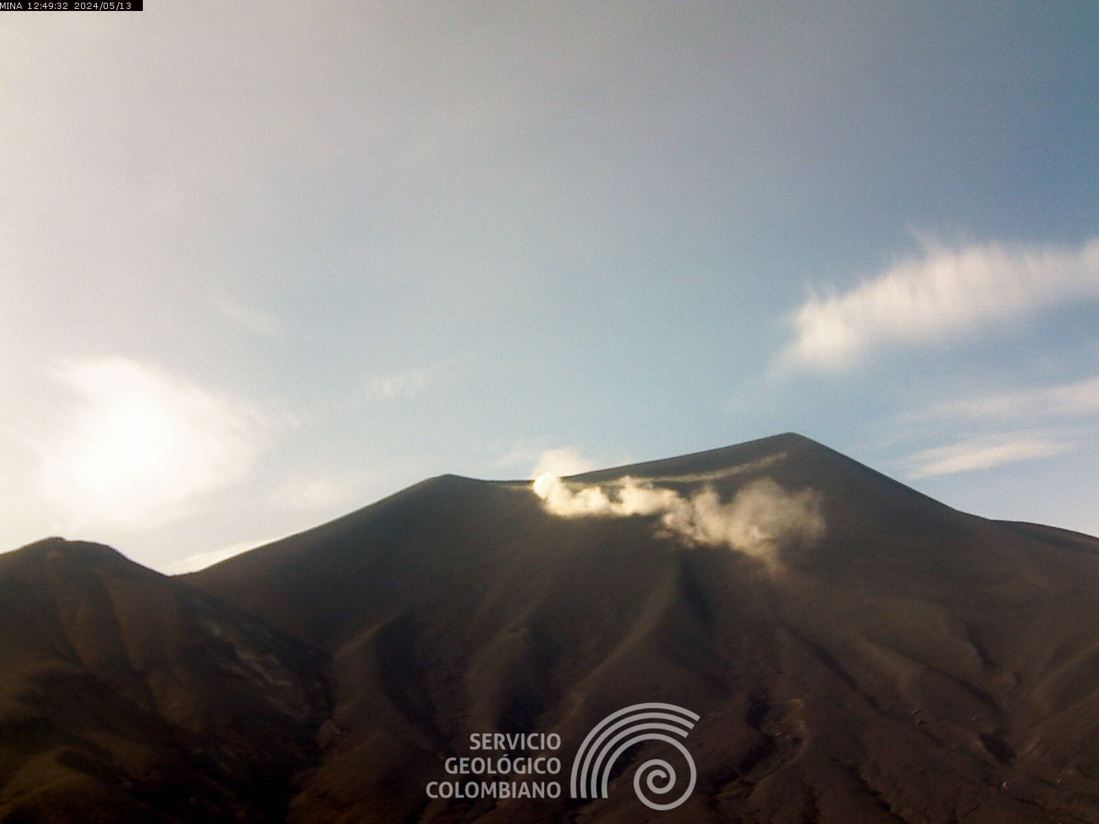
Colombia , Puracé :
Popayan, May 15, 2024, 3:30 p.m.
Regarding the monitoring of the activity of the PURACE VOLCANO – LOS COCONUCOS VOLCANIC CHAIN, the COLOMBIAN GEOLOGICAL SERVICE (SGC), an entity attached to the MINISTRY OF MINES AND ENERGY, reports that:
From yesterday until the time of publication of this bulletin, the seismic activity associated with fracture processes, as well as that linked to the movement of fluids, maintained a behavior similar to that observed in previous days, with a downward trend the number of earthquakes. The fracture events were located mainly under the crater of the Puracé volcano and, to a lesser extent, on the eastern flank. Depths were between 0.5 and 2.4 km. The maximum magnitude calculated was 1.5 ML, corresponding to an earthquake recorded yesterday at 6:21 p.m.
Seismicity linked to the movement of fluids continues to be concentrated in the crater sector and on its northern flank, at depths less than 2.0 km.
In the images obtained this morning, it was not possible to have a clear view of the crater. Ground deformation processes and the concentrations of carbon dioxide (CO2) and sulfur dioxide (SO2) gases maintain the observed trend, with values that remain above the known baselines for this volcano.
The SGC confirms that the alert state of the PURACE VOLCANO continues at ORANGE: volcano with significant changes in the monitored parameters.
Observatorio Vulcanológico y Sismológico de Popayán, Servicio Geologico Colombiano (SGC) reported that the number of both volcanic tremor (VT) and long-period (LP) seismic events at Puracé were stable during 7-13 May with only a slight increase in both the number and intensity of LP events on 9 May. The VT events had low magnitudes and were located at depths up to 4 km beneath the volcano and its E flank. The largest VT events were a M 1.8 recorded at 23h51 on 7 May and at 22h02 on 10 May. LP earthquakes were located in similar areas as the VT events, at depths less than 2 km. Earthquakes indicating magma movement were recorded during 7-9 May. Inclement weather sometimes prevented visual observations of emissions, though during the second part of the week diffuse fumarolic emissions from the crater and the crater rim were visible. Both carbon dioxide and sulfur dioxide emissions remained above baseline levels. The Alert Level remained at Orange (the second highest level on a four-color scale).
Source : SGC, GVP.
Photo : SGC.
Japan , Sakurajima :
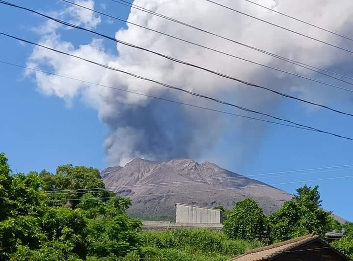
JMA reported ongoing eruptive activity at Minamidake Crater (Aira Caldera’s Sakurajima volcano) during 6-13 May with nighttime crater incandescence. Very small eruptive events were recorded. Sulfur dioxide emissions were high, averaging 2,000 tons per day on 7 May. The Alert Level remained at 3 (on a 5-level scale), and the public was warned to stay 1 km away from both craters.
The Aira caldera in the northern half of Kagoshima Bay contains the post-caldera Sakurajima volcano, one of Japan’s most active. Eruption of the voluminous Ito pyroclastic flow accompanied formation of the 17 x 23 km caldera about 22,000 years ago. The smaller Wakamiko caldera was formed during the early Holocene in the NE corner of the caldera, along with several post-caldera cones. The construction of Sakurajima began about 13,000 years ago on the southern rim and built an island that was joined to the Osumi Peninsula during the major explosive and effusive eruption of 1914. Activity at the Kitadake summit cone ended about 4,850 years ago, after which eruptions took place at Minamidake. Frequent eruptions since the 8th century have deposited ash on the city of Kagoshima, located across Kagoshima Bay only 8 km from the summit. The largest recorded eruption took place during 1471-76.
Source: Japan Meteorological Agency (JMA), GVP.
Photo : Wulkany świata