April 22 , 2024.
Indonesia , Ili Lewotolok :
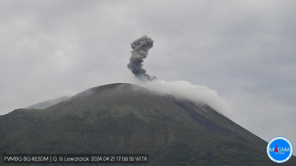
An eruption of Mount Ili Lewotolok occurred on Sunday, April 21, 2024 at 5:02 p.m. WITA with the height of the ash column observed at ±400 m above the summit (±1823 m above sea level). The ash column was gray in color with moderate to thick intensity, oriented to the West and Northwest. This eruption was recorded on a seismograph with a maximum amplitude of 19.9 mm and a duration of 52 seconds.
Observation of seismicity:
3 eruption earthquakes with an amplitude of 27.9 to 30.8 mm and earthquake duration of 32 to 38 seconds.
79 emission earthquakes with an amplitude of 2.2 to 27.1 mm and earthquake duration of 28 to 333 seconds.
1 Non-harmonic tremor with an amplitude of 3.6 mm and an earthquake duration of 682 seconds.
2 deep tectonic earthquakes with an amplitude of 4.3 to 5.4 mm, and the duration of the earthquake was 70 to 122 seconds.
At activity level Level III (SIAGA), it is recommended:
Communities around Mount Ili Lewotolok as well as visitors/climbers/tourists should not enter or conduct activities within a 2 km radius of the Mount Activity Center. Ili Lewotolok, and residents of Lamatokan Village and Jontona should always be aware of potential threats from lahars and hot cloud avalanches from the eastern summit/crater of Mt. Ili Lewotolok.
To avoid respiratory problems (ARI) and other health problems caused by volcanic ash, residents living around Mt. Ili Lewotolok may use masks to protect their mouth and nose and other equipment to protect their eyes and skin.
Source et photo : Magma Indonésie
Ecuador , Sangay :
DAILY REPORT ON THE STATE OF THE SANGAY VOLCANO, Sunday April 21, 2024.
Information Geophysical Institute – EPN.
Surface activity level: High, Surface trend: Descending
Internal Activity Level: High, Internal Trend: Descending
Seismicity: From April 12, 2024, 11:00 a.m. to April 13, 2024, 11:00 a.m.:
The number of seismic events recorded at the reference station over the past 24 hours is shown below. The level of seismic activity of the volcano remains high.
Explosion Event (EXP): 429
Precipitation/Lahars:
Yesterday afternoon, at the time of writing this report, thanks to the surveillance camera system, rains were recorded in the volcano area without generating mudflows and debris. *In the event of heavy rains, these could remobilize the accumulated materials, generating mud and debris flows which would flow down the sides of the volcano and flow into adjacent rivers.*
Emissions/ash column:
Since yesterday afternoon, at the time of writing this report, thanks to the surveillance camera system, it has not been possible to record gas or ash emissions due to the climatic conditions in the area.
Observation:
From yesterday afternoon until today morning, according to the surveillance camera system and satellite images, the volcano remained completely cloudy, without presenting any major news.
Alert level: yellow
Source : IGEPN.
Photo : Eqphos_fotografía
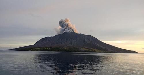
Indonesia , Ruang :
Reduction of the activity level of G. RUANG from level IV (AWAS) to level III (alert).
Visual observation
On April 16, 2024 at 1:37 p.m. WITA, a low-intensity eruption was observed, with thick white smoke. An explosive eruption occurred on April 16, 2024 at 9:45 p.m. WITA with an estimated height of the eruptive column reaching 2,000 m above the summit. Then the eruption occurred again on April 17, 2024 at 01:08 WITA with the height of the eruptive column estimated at 2,500 m and accompanied by sounds of roaring and explosions.
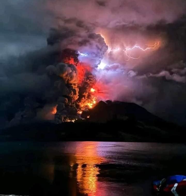
An eruption occurred again on April 17, 2024 at 05:05 WITA with the height of the eruptive column estimated at 1,800 m above the summit. On April 17, 2024, at 6:00 p.m. WITA, an eruption occurred at a height of 2,500 m above the summit, then at 8:15 p.m. WITA, another explosive eruption occurred with the height of the eruption column observed as being gray to black in color with a height of approximately 3,000 m above the summit, accompanied by a roar and earthquake that was felt at the PGA Room Post. The eruption occurred again on April 20, 2024 at 01:09 WITA, producing a gray-black eruption column approximately 1,200 m above the summit.
Visual observations from April 22, 2024 between 00:00 and 06:00. WITA observed a thick emission column of white gas with a maximum height of 250 m. Based on the column color of the emission, dominated by gas/water vapor, no ash/rock material rising to the surface was detected.
Instrumental observation
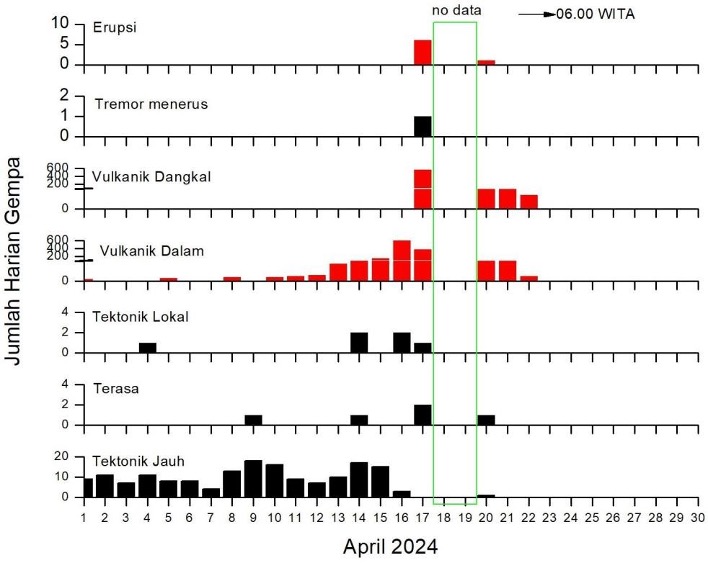
Between April 1 and 22, 2024, the earthquakes recorded on G. Ruang were:
1352 deep volcanic earthquakes (VTA),
658 shallow volcanic earthquake (VTB)
7 eruptions, 6 local tectonic earthquakes,
167 times distant tectonic earthquakes.
Earthquakes were recorded 5 times on the MMI I scale. The number of earthquakes, especially deep volcanic earthquakes occurring between April 1 and 21, 2024, showed a significant increase compared to March 2024.
The earthquakes from April 17 to 21, 2024 are as follows:
April 17, 2024 earthquake: the number of deep volcanic earthquakes (VTA) recorded was 373 events, shallow volcanic earthquakes (VTB): 564 events, 2 felt earthquakes and 1 tectonic earthquake local.
Earthquake of April 18, 2024: Damaged equipment
Earthquake of April 19, 2024: Damaged equipment
Earthquake of April 20, 2024: the number of deep volcanic earthquakes (VTA) was recorded at 50. Shallow volcanic earthquakes (VTB) 48, 1 eruption, 1 deep tectonic earthquake and 1 felt earthquake.
Earthquake of April 21, 2024: the number of deep volcanic earthquakes (VTA) recorded was 28 events and that of shallow volcanic earthquakes (VTB) was 43 events,
April 22, 2024 Earthquake: 00:00 – 00:06 WITA, the number of deep volcanic earthquakes (VTA) was recorded at 5 events and shallow volcanic earthquakes (VTB) 14 events.
Assessment
In general, the volcanic seismicity of Mount Ruang tends to be low, dominated by tectonic earthquakes, thought to be the influence of North Sulawesi subduction and double subduction in the Molucca Sea. However, the volcanic activity of Mount Ruang between April 1 and 17, 2024 saw an escalation with the emergence of deep volcanic earthquakes (VTA) after the tectonic earthquake of April 9, 2024 and April 14, 2024. According to BMKG, the tectonic earthquake of April 9, 2024 had a magnitude of 6.4, a depth of 27 km and was located 94 km northwest of the island of Doi, in the North Moluccas.
Meanwhile, the April 14 tectonic earthquake had a magnitude of 5.1, a depth of 10 km and was located 122 km southwest of the island of Doi, in the North Moluccas.
Both tectonic earthquakes were felt on the I MMI scale and are believed to be related to double subduction activity in the Molucca Sea. The occurrence of deep volcanic earthquakes (VTA) is generally linked to the migration of magma from the depths to the surface. Meanwhile, the potential danger from G. Ruang that could arise is in the form of an explosive eruption producing hot clouds, in the southwest – south – southeast direction.
After the eruption of April 17, 2024, the frequency of deep volcanic earthquakes (VTA) and shallow volcanic earthquakes (VTB) tends to decrease.
Recommendation
Based on the results of visual and instrumental monitoring which show a decrease in volcanic activity on Mount Ruang, the activity level of Mount Ruang was lowered from level IV (AWAS) to level III (SIAGA) from from April 22, 2024 at 09:00 WITA.
Source : PVMBG
Photos : Vian Apeles Togas , PVMBG.
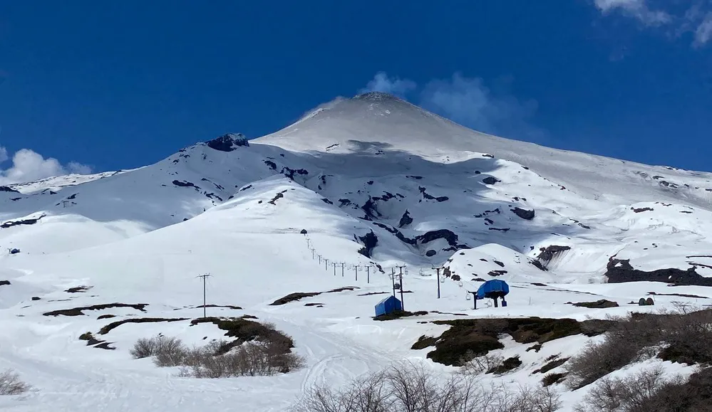
Chile , Villarica :
Special Report on Volcanic Activity (REAV), Auracania region, Villarica volcano, April 22, 2024, 01:45 a.m. local time (mainland Chile).
The National Service of Geology and Mines of Chile (Sernageomin) publishes the following PRELIMINARY information, obtained using the monitoring equipment of the National Volcanic Monitoring Network (RNVV), processed and analyzed at the Southern Andean Volcanological Observatory ( Ovdas):
On Monday, April 22, at 01:25 local time (05:25 UTC), monitoring stations installed near the Villarica volcano recorded an earthquake associated with fluid dynamics inside the volcanic system (long period).
The characteristics of earthquakes after their analysis are as follows:
ORIGINAL TIME: 01:25 local time (05:25 UTC)
REDUCED TRAVEL: 75.5 (cm*cm)
ACOUSTIC SIGNAL: 8.8 Pascals (Pa) reduced to 1 km
OBSERVATIONS:
The poor weather conditions present in the area made it impossible to observe whether the activity was associated with a surface event.
The technical volcanic alert remains at the Yellow level.
Source Sernageomin.
Photo : Auracaniadiario
Guatemala , Fuego :
Weather conditions: Clear weather.
Wind: North-East.
Precipitation: 0.0 mm.
Activity:
The Fuego Volcano Observatory reports volcanic activity, with weak explosions and occasional moderate or strong ones, occurring at a rate of 4 to 7 per hour, raising columns of gas and gray ash, to heights between 4,500 and 4,800 meters above sea level (14,764 to 15,748 feet).
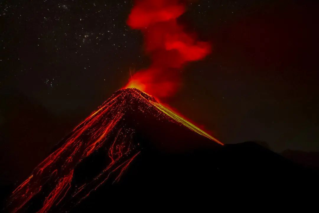
The wind disperses them towards the Southwest, and a weak fall of ash particles can occur on Sangre de Cristo, Palo Verde, El Porvenir, Santa Sofía, Los Yucales, Morelia, Panimaché I and Panimaché II. The explosions produce weak to moderate avalanches around the crater towards the Ceniza, Taniluyá, Seca and Las Lajas ravines, some reaching the vegetation limit. The activity is accompanied by low to moderate rumbles and shock waves as well as train engine noises sometimes lasting up to 4 minutes. In the afternoon and evening, the forecast rains could cause lahars to descend in different ravines of the volcano.
Source : Insivumeh
Photo : Desnivel Tour