April 17 , 2024.
Indonesia , Ruang :
Increase in the activity level of G. Ruang from level II (WASPADA) to level III (SIAGA).
The evaluation report on the activities of G. Ruang, North Sulawesi is hereby submitted as follows:
Visual observation
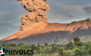
Visual observations of G. Ruang for the period April 1 to 16, 2024: generally the weather is sunny to rainy. The volcano is clearly visible until it is covered in fog. Smoke from the crater began to be observed on the morning of April 16 at a height of 200 to 500 m. A thick, white, smoky color is observed. At 1:37 p.m. WITA, an eruption was observed with thick, low-intensity white smoke. The air temperature is around 26-32°C.
Instrumental observation
Between April 1 and 15, 2024, the earthquakes recorded on Mount Ruang were 210 deep volcanic earthquakes (VTAs), 3 local tectonic earthquakes, and 163 deep tectonic earthquakes. Felt earthquakes were recorded twice on the MMI I scale. The number of earthquakes, especially deep volcanic earthquakes occurring between April 1 and 15, showed a significant increase compared to March 2024. Over a 12-hour period, from 00:00 to 12:00 WITA, the number of deep volcanic earthquakes amounted to 198 events and 2 distant tectonic earthquakes were recorded.
G. Ruang volcanic activity increased after the tectonic earthquake and was felt in the G. Ruang region. Number of deep volcanic earthquakes (VTA) recorded: April 10, 2024 (occurred 4 times), April 11, 2024 (5 times), April 12, 2024 (6 times), April 13, 2024 (17 times), April 14, 2024 (23 times), April 15, 2024 (146 times) and April 16, 2024 – until 12:00 p.m. (198 times).
Assessment
In general, the volcanic seismicity of Mount Ruang tends to be low, dominated by tectonic earthquakes, thought to be the influence of North Sulawesi subduction and double subduction in the Molucca Sea. However, the volcanic activity of Mount Ruang between April 1 and 16, 2024 saw an escalation in the emergence of deep volcanic earthquakes (VTA) after the tectonic earthquake of April 9, 2024 and April 14, 2024. According to BMKG, the tectonic earthquake of April 9, 2024 had a magnitude of 6.4, a depth of 27 km and was located 94 km northwest of the island of Doi, in the North Moluccas. Meanwhile, the April 14 tectonic earthquake had a magnitude of 5.1, a depth of 10 km and was located 122 km southwest of the island of Doi, in the North Moluccas. Both earthquakes were felt on the I MMI scale. The occurrence of deep volcanic earthquakes (VTA) is generally linked to the migration of magma from the depths to the surface.
The potential dangers of G. Ruang that may arise are in the form of an explosive eruption producing hot clouds, in the southwest, south – southeast direction.
Recommendation
Based on the results of visual and instrumental monitoring that show an increase in volcanic activity on Mount Ruang, the activity level of Mount Ruang was increased from level II (WASPADA) to level III (SIAGA) from from April 16, 2024 at 4:00 p.m. WITA. .
Communities around Mount Ruang and visitors/tourists should remain vigilant and not enter the area within a 4 km radius from the center of the active crater of Mount Ruang.
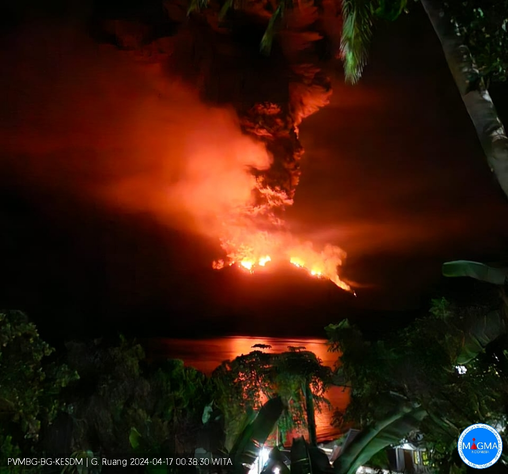
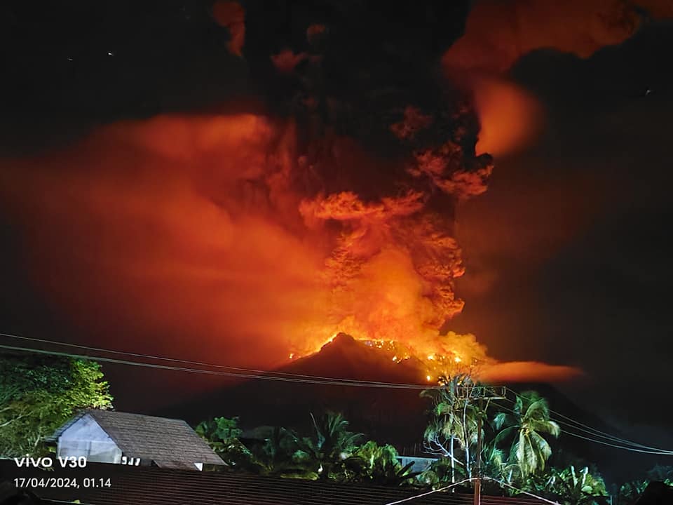
An eruption of Mount Ruang occurred on Wednesday, April 17, 2024, at 01:08 WITA. The height of the eruptive column was not observed. At the time of writing, the eruption was still ongoing.
VOLCANO OBSERVATORY NOTICE FOR AVIATION – VONA
Issued : April 16 , 2024
Volcano : Ruang (267010)
Current Aviation Colour Code : ORANGE
Previous Aviation Colour Code : YELLOW
Source : Ruang Volcano Observatory
Notice Number : 2024RUA001
Volcano Location : N 02 deg 18 min 11 sec E 125 deg 22 min 00 sec
Area : North Sulawesi, Indonesia
Summit Elevation : 2320 FT (725 M)
Volcanic Activity Summary :
Increasing in volcanic activity.
Volcanic Cloud Height :
Best estimate of ash-cloud top is around 3920 FT (1225 M) above sea level or 1600 FT (500 M) above summit. May be higher than what can be observed clearly. Source of height data: ground observer.
Other Volcanic Cloud Information :
Ash cloud moving from south to west. Volcanic ash is observed to be white to gray. The intensity of volcanic ash is observed to be medium.
Remarks :
Eruption and ash emission is continuing. Eruption recorded on seismogram with maximum amplitude 55 mm. Rumbling sound heard from Ruang Volcano Observatory
Source : PVMBG
Photos : Vivo V30 , PVMBG.
Italy , Stromboli :
WEEKLY BULLETIN, from April 8, 2024 to April 14, 2024. (issue date April 16, 2024)
SUMMARY STATEMENT OF ACTIVITY
In light of the monitoring data, it appears:
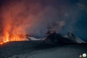
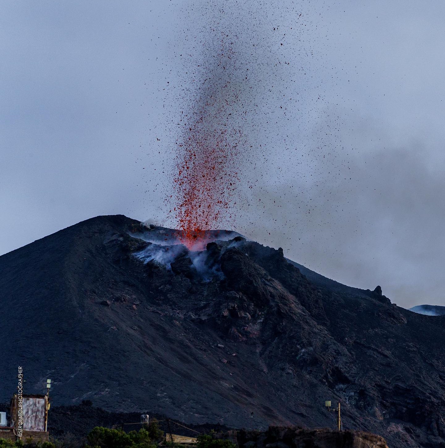
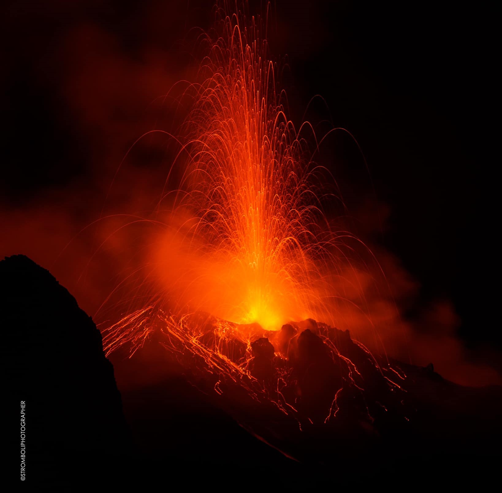
1) VOLCANOLOGICAL OBSERVATIONS: Normal Strombolian activity was observed during this period. The total hourly frequency fluctuated between medium values (8 events/h) and high values (17 events/h). The intensity of the explosions was low and sometimes medium in the areas of the North and South-Central craters.
2) SISMOLOGY: The monitored seismological parameters do not show significant variations.
3) GROUND DEFORMATIONS: The ground deformation monitoring networks did not show significant variations.
4) GEOCHEMISTRY: SO2 flux at medium level
The CO2 flux in the summit zone is at medium-high values.
C/S ratio in the plume: transmission restored, average values.
Helium Isotope Ratio in Thermal Aquifer: There are no updates.
CO2 flux in Mofeta in the San Bartolo area: medium-low values.
CO2 flux in Scari: stable values at average levels.
5) SATELLITE OBSERVATIONS: Thermal activity observed by satellite was generally low level with some rare and isolated thermal anomalies of moderate level.
VOLCANOLOGICAL OBSERVATIONS
In the observed period, the eruptive activity of Stromboli was characterized through the analysis of images recorded by the INGV-OE surveillance cameras located at Pizzo (SPT), at altitude 190 (SCT-SCV) and at Punta dei Corvi (SPCT). The explosive activity was mainly produced by 2 (two) eruptive vents located in the northern area of the crater and by 3 (three) vents located in the south central area.
Observations of explosive activity captured by surveillance cameras
In the area of the North crater (N), with a mouth located in sector N1 and a mouth located in sector N2, explosive activity was observed which was constant in sector N1 and sporadic in sector N2. In sector N1 the intensity was low (less than 80 m in height) and sometimes medium (less than 150 m in height) while in sector S2 the explosions were of low intensity (a few tens of meters). The products emitted in the eruption were mainly coarse materials (bombs and lapilli). The average frequency of explosions oscillated between 2 and 7 events/h.
In the South-Central (CS) zone, sector C did not show significant activity while in sector S1, sporadic and low gas emissions were observed. In sector S2, with two emission points, the explosions were mainly of low intensity (less than 80 m in height) and sometimes of medium intensity (less than 150 m in height) emitting fine materials mixed with large ones. The average frequency of explosions varied from 2 to 10 events/h.
Field observations of explosive activity.
On the morning of April 9, researchers from the I.N.G.V. within the framework of Annex A and the UN departmental project, carried out an inspection in the summit area to carry out the maintenance of the monitoring stations, sampling of erupting products and analysis of the morpho-structural changes of the crater terrace.
In the northern zone of the crater (N), the mouth of sector N1 mainly produced ash emissions, while at the mouth of sector N2, only degassing activity was observed.
In the Central South Crater (CS) area, sector S1 is made up of a hornito which produced weak but continuous degassing. In sector S2, at least 2 vents were active, the largest of which, the southern one, produced modest Strombolian explosions with the emission of few coarse materials mixed with ashes, while the adjacent one (further to the North) showed emissions almost mainly of ash. These 2 mouths were often active at the same time.
Sector C is currently occupied by a depression which has shown no evidence of volcanic activity in terms of eruptive vents or fumarolic activity. However, there is a vent on the outer side of sector S2 which faces sector C, with continuous degassing activity.
Source : INGV
Photos : Stromboli stati d’animo / Sebastiano Cannavo.
Indonesia , Awu :
Increase in the activity level of Mount Awu, North Sulawesi from level II (Waspada) to level III (SAIGA).
The results of the assessment of the activities of G. Awu, Sangihe Islands, North Sulawesi, for the period April 1 to 15, 2024, are presented as follows.
Visual observation
The volcano is clearly visible until it is covered in fog. Smoke coming from the main crater was not observed. The weather is sunny to rainy, with light to moderate winds from the South, South-West and West. The air temperature is around 23-32°C.
Instrumental observation
Over the past two weeks, the seismicity of Mount Awu has been dominated by shallow volcanic earthquakes and deep volcanic earthquakes. Complete earthquake details were recorded as 1 low frequency earthquake, 284 shallow volcanic earthquakes, 71 deep volcanic earthquakes, 14 local tectonic earthquakes and 252 distant tectonic earthquakes.
Assessment
No visual observation of the height of the emissions column was observed during this period. This is believed to be because magmatic gas from deep below was unable to penetrate to the surface, so no smoke was observed on the surface of G. Awu crater. Even if surface activity has not experienced significant changes, visual changes can occur rapidly at any time.
The number of volcanic earthquakes (deep volcanic and shallow volcanic) fluctuates depending on how many are above normal conditions. A series of volcanic earthquakes were recorded on March 22, 2024 at 5:00 p.m. WITA (3 deep volcanic, 12 shallow volcanic) and 7:15 p.m. WITA (7 shallow volcanic). On March 18 and 19, 2024, non-harmonic tremor vibrations with a seismic duration of 45 to 57 seconds were recorded, indicating the presence of surface seismic activity.
This series of volcanic earthquakes was recorded again on:
April 10, 2024 at 6:12 p.m. WITA and 6:54 p.m. WITA (5 Deep Volcanics, 46 Shallow Volcanics).
April 11, 2024 from 10:46 p.m. to 10:53 p.m. WITA (1 deep volcanic, 5 shallow volcanic). On April 11, 2022, 1 low-frequency earthquake was recorded with an amplitude of 4 mm and an earthquake duration of 26 seconds.
April 12, 2024 from 09:42 to 09:57 WITA (1 deep volcanic, 14 shallow volcanic).
April 12, 2024 from 12:11 p.m. to 12:21 p.m. WITA (3 deep volcanics, 11 shallow volcanics). After a series of volcanic earthquakes on April 12, 2022, 2 local tectonic earthquakes were recorded.
April 13, 2024 at 02:43 WITA (8 Shallow Volcanics) and 04:23 WITA (6 Shallow Volcanics, 1 Local Tectonics).
April 15, 2024 at 2:42 p.m. WITA (2 Deep Volcanics, 7 Shallow Volcanics).
The tremor energy increased, on the RSAM graph.
Monitoring the deformation of Mount Awu using an inclinometer between March 1, 2024 and April 16, 2024 at Kolongan Station and Puncak Station shows that there is inflation (increasing pressure).
From the results of visual observations, seismicity and deformation, the intrusion of magma at depth towards the surface is still recorded instrumentally. This is indicated by the emergence of deep volcanic and shallow volcanic seismicity. The emergence of local high-intensity tectonic earthquakes can also trigger increased volcanic activity on Mount Awu. Apart from this, one should be wary of large and continuous energy earthquakes which have the potential to break the lava dome and cause explosive eruptions.
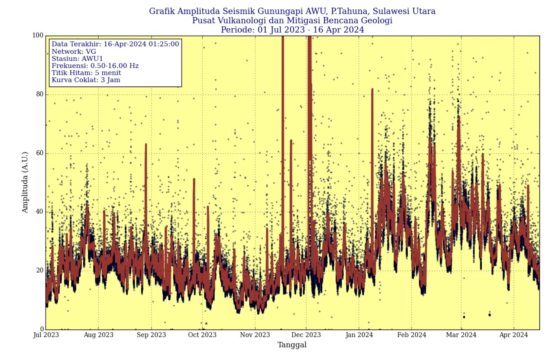
The increase in shallow earthquakes on Mount Awu has been going on for quite a long time, showing that there is a process of pressure buildup at shallow depths that can trigger large-scale explosive eruptions. This increase in seismicity can also be seen from the reference seismic energy (RSAM) for the period from July 2023 to April 16, 2024, which is higher than the reference seismic energy (RSAM) for the period from 1 December 2021 to September 9, 2022, namely during the G. Awu crisis period of 2022.
Recommendation
Based on the results of visual and instrumental monitoring of Mount Awu showing increased activity and potential danger threats, the activity level of Mount Awu was increased from Level II (WASPADA) to Level III (SIAGA ), starting April 16, 2024 at 6:00 p.m. WITA.
Source et photo : PVMBG
Iceland , Reykjanes Peninsula :
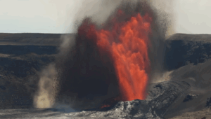
Updated risk assessment. The eruption of the Sundhnúks crater series has been going on for a month. The uprising has continued at a similar pace since early April.
Updated April 16 at 2:45 p.m.
Updated hazard assessment. The overall risk for Grindavík (zone 4) is considered considerable (orange).
A crater continues to erupt a short distance east of Sundhnúk.
The uprising continues. Stable since the beginning of April.
There is always a risk of gas pollution. Residents in the area are advised to monitor air quality.
A gas distribution forecast can be viewed here.
The eruption of the Sundhnúks crater series is continuing and has now been going on for a month, as noted in a press release issued earlier today. A crater continues the eruption a short distance east of Sundhnúk. Lava continues to flow south from the crater but does not go far and the lava bed continues to build up near the crater. An active lava rim is found near Hagafell, as can be seen in a photo from the Met Office webcam located at Þorbirn.
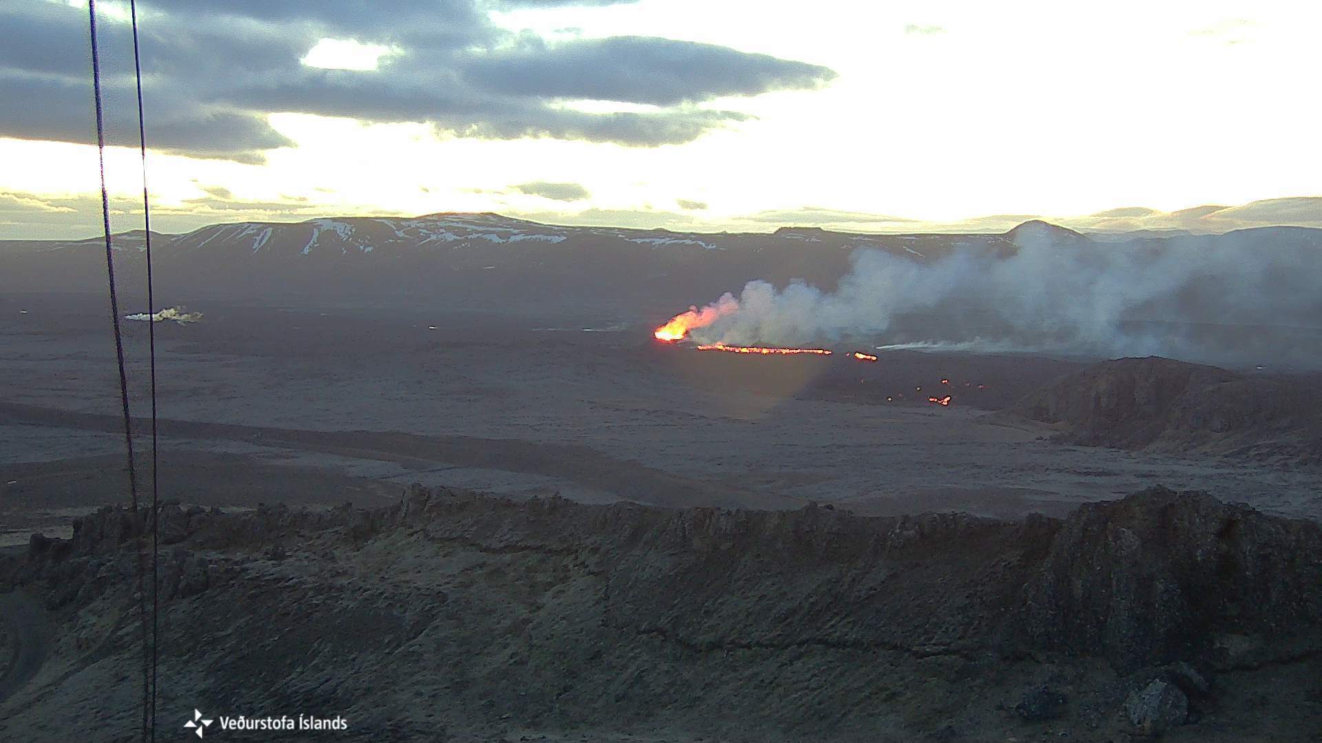
Photo from 5:10 this morning, April 16, taken from the Met Office web camera, located at the summit of Þorbirn and looking east towards the eruption. In the middle of the image is the crater and the lava coming out of it. Opposite is Sundhnúkur and on the right side of the photo you can see Hagafell where you can see the active lava rim.
Seismic activity was rather quiet in the eruption zone from the start of the eruption, until the start of small earthquakes on the afternoon of April 14 in Lágafell. This swarm lasted over 4 hours and was linked to stress changes in the crust due to landslides at Svartsengi. There is still a small amount of persistent seismic activity in the western part of Fagradalsfjall at a depth of about 6 to 8 km, which has accompanied the upheavals of the last 4 months.
Updated risk assessment
The risk assessment has been updated and is valid today at 3:00 p.m. until April 23. The changes concern the assessment of the risk due to the cessation of the lava flow which has been stopped in all zones, with the exception of zone 3 (Sundhnúks crater series) and zone 6. This change is brought because there has been no active lava flow in other areas of the region over the past two weeks. Based on the activity of the current eruption, there is less chance of lava flowing away from the crater and into other dangerous areas.
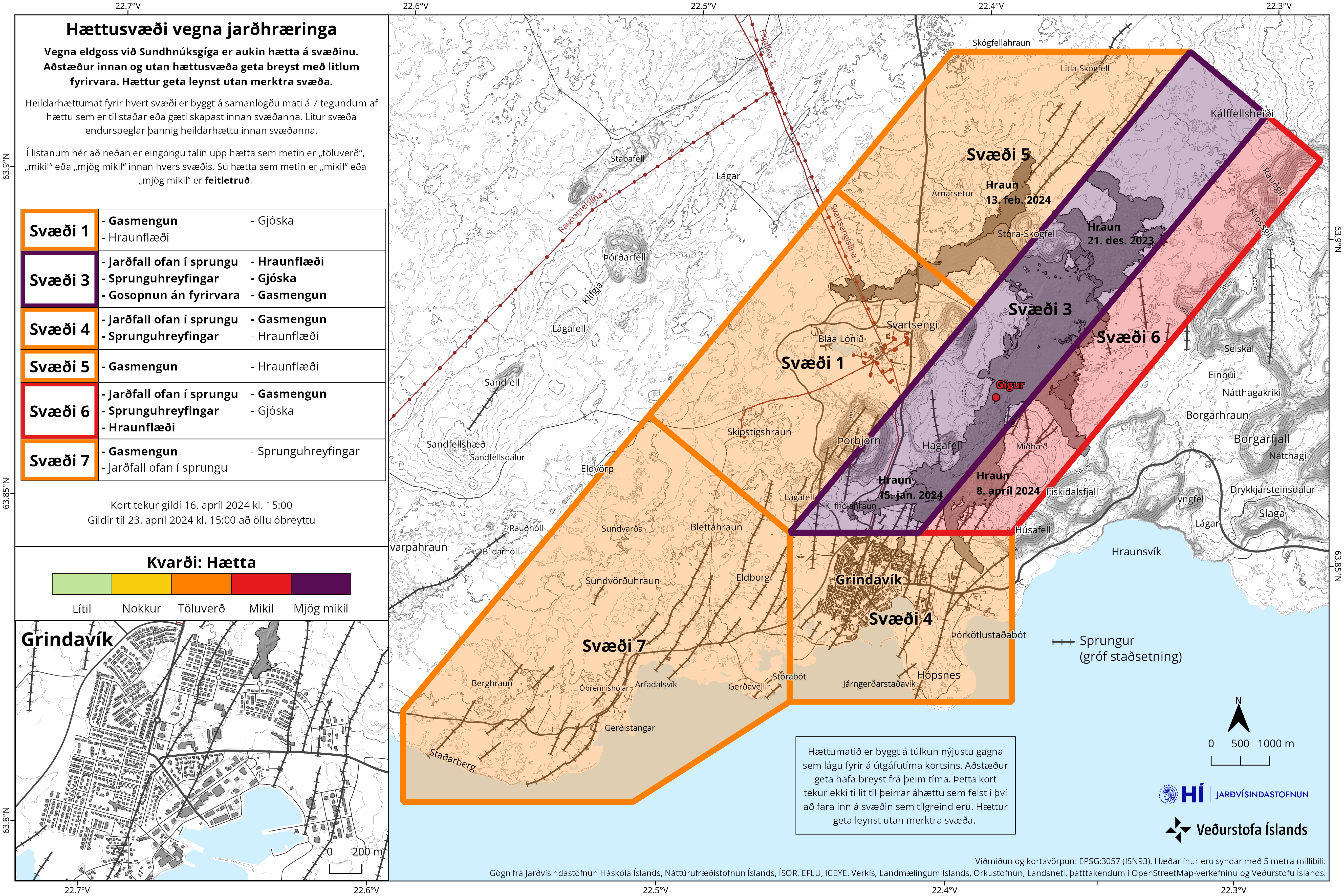
This change means that the total risk in Zone 4 (Grindavík) is now estimated to be considerable (orange), whereas it was previously high (red). The overall risk in other areas remains unchanged. The risk caused by gas pollution remains high in all areas, with the exception of the Sundhnúks crater series (zone 3), where it is assessed as very high. The risk in zone 4 (Grindavík) and zone 6 is still assessed as high due to crack movements.
Source et photos : IMO
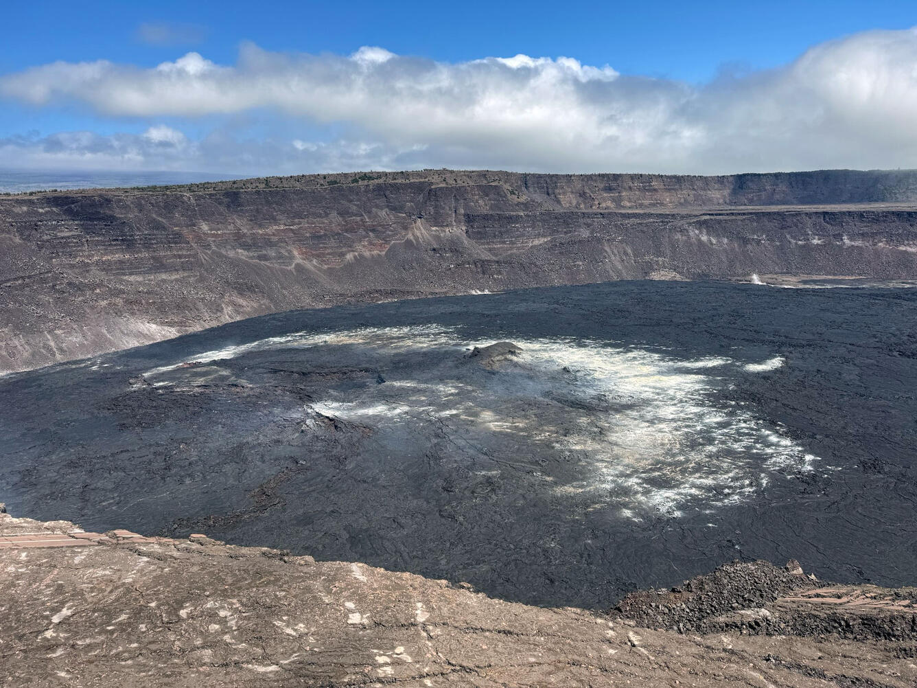
Hawaii , Kilauea :
HAWAIIAN VOLCANO OBSERVATORY WEEKLY UPDATE
Tuesday, April 16, 2024, 11:13 AM HST (Tuesday, April 16, 2024, 21:13 UTC)
19°25’16 » N 155°17’13 » W,
Summit Elevation 4091 ft (1247 m)
Current Volcano Alert Level: ADVISORY
Current Aviation Color Code: YELLOW
Activity Summary:
Kīlauea volcano is not erupting. Rates of seismic activity increased beneath the summit over the past week. Seismicity coupled with low rates of deformation indicate some magma continues to accumulate beneath the summit and south caldera region and also beneath the lower Southwest Rift Zone. There are currently no signs of imminent eruption, but HVO continues to monitor activity at Kilauea volcano closely.
Summit Observations:
Rates of seismic activity beneath Kīlauea summit doubled over the past week. While the total number of detected events remains relatively low, brief sequences of elevated activity have occurred several times over the past week. Regions of elevated activity beneath Kīlauea summit include a sequence of deeper earthquakes (~8 mi below surface) beneath Kīlauea’s summit, and shallow earthquake activity (~1.5 mi below surface) within the volcano’s south caldera region. Magnitudes for these events are typically low (at or below M1+, sometimes too small to detect). Ground deformation continues to indicate low rates of long-term inflation across Kīlauea’s summit.
Sulfur dioxide (SO2) gas emissions have remained at low, noneruptive levels since October 2023. An SO2 emission rate of approximately 96 tonnes per day was recorded on April 8.
Rift Zone Observations:
Low levels of seismicity continue beneath Koa’e fault zone and into the lower Southwest Rift Zone. Ground deformation, recorded by GPS instruments, shows on-going deformation across this region, a sign that magma continues to migrate downrift. No unusual activity has been noted along the East Rift Zone. We continue to closely monitor both rift zones.
Source : HVO
Photo : USGS / M. Patrick