March 23 , 2024.
Iceland : Reykjanes Peninsula :
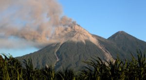
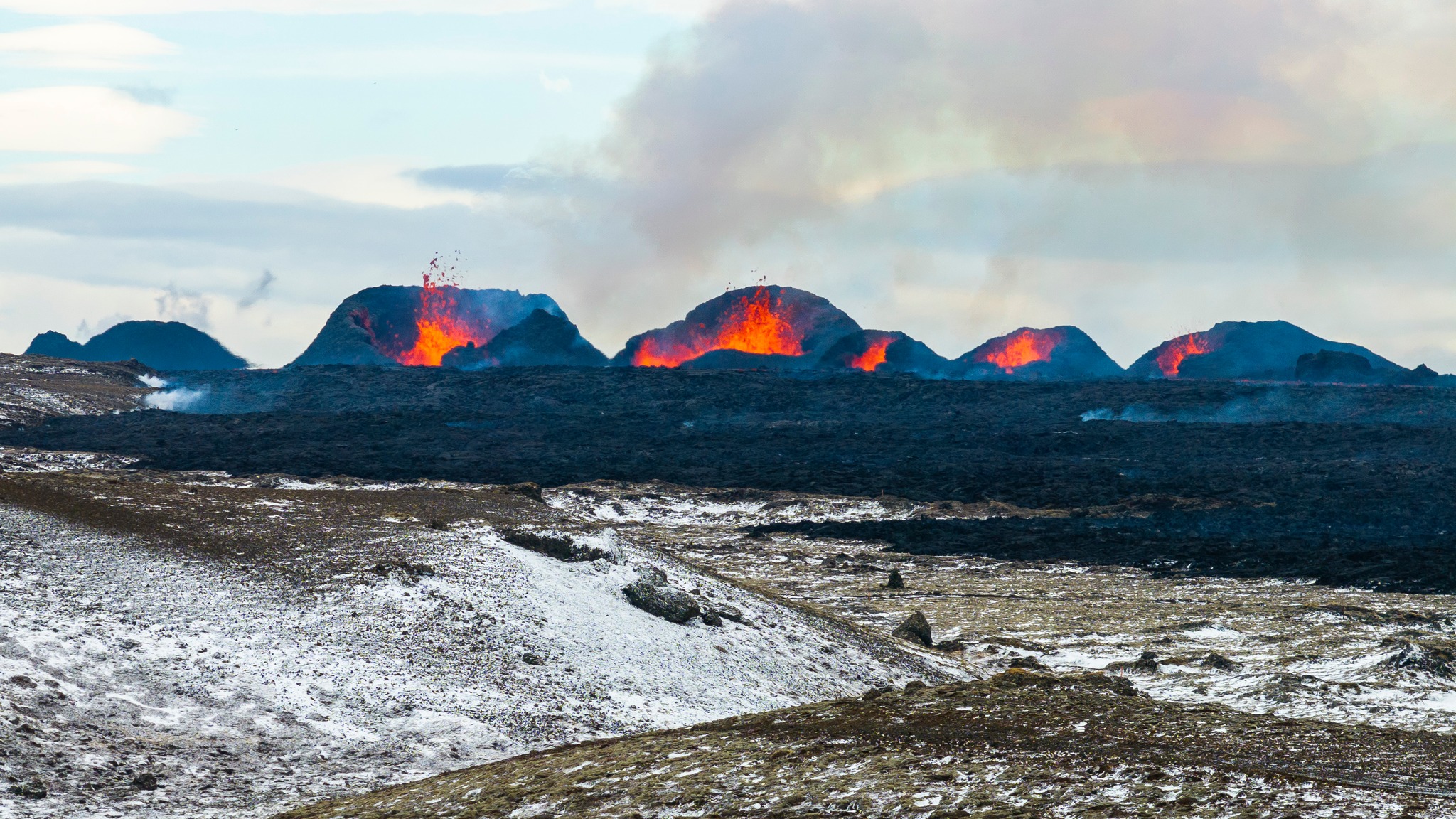
Stable eruptive activity . Lava flows south from the craters in an active stream .
Updated 21. March at 11:40 UTC
Average discharge rate for 17 – 20 March is 14.5 m3/s
The new lava now covers an area of 5.58 km2 and has a volume of 20.9 million cubic meters.
Accumulation of magma below Svartsengi seems to have stopped and instead magma flows directly to the surface and feeds the eruption.
Minor deformation has been measured in the Svartsengi area and in the proximity of the dyke intrusion.
The eruptive activity appears to have been relatively stable the last 24 hours. The same vents seem to be active, and craters continue to build up around the vents. Lava flows towards the south from the craters in an active lava stream, both on the surface and below the solidified surface of the lava.
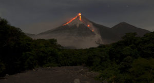
Overview of the eruption site taken on a flight yesterday morning 20 March at 9am. It shows all the active volcanic vents.
Yesterday morning experts from the National Land Survey of Iceland and the Institute of Natural History conducted aerial photography flights over the eruption site. From these images it is estimated that over the period from 17-20 March the average discharge rate of the eruption is 14.5 m3/s. This is similar discharge rate as observed during the eruptions in Fagradalsfjall 2021-2023. However, the discharge rate during the first 24 hours of the eruption was significantly higher. The area of the new lava field was measured 5.58 km2 and the volume 20.9 million cubic meters. The map below shows the extent and thickness of the new lava as measured yesterday morning, 20 March. The lava is 16 m thick where its thickest by the craters.
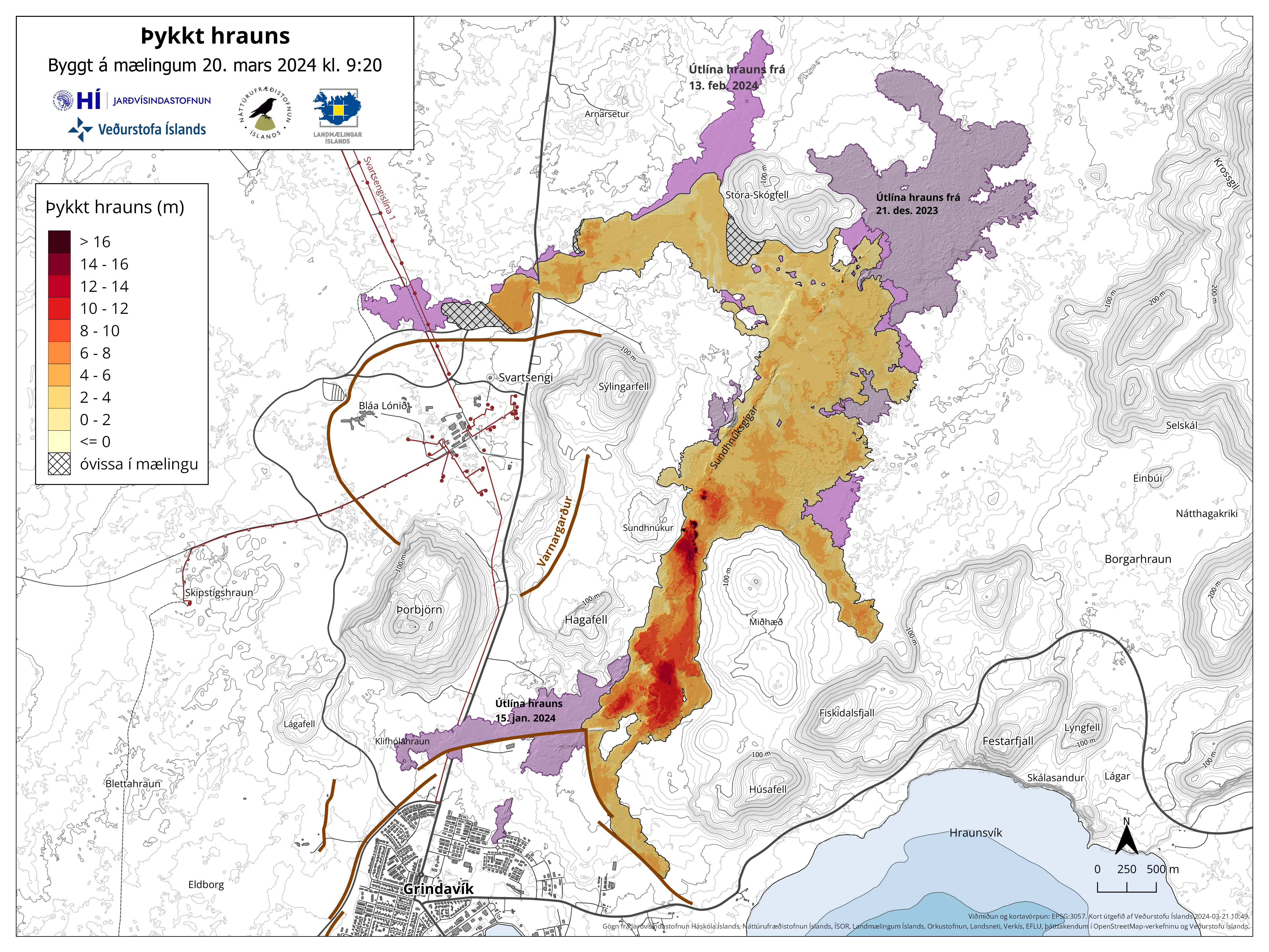
Map showing the extent of the newly erupted lava. Violet layers show the older lava that erupted in December 2023, January 2024 and February 2024.
Very little deformation has been measured in the Svartsengi area and in proximity of the dyke formation. Any measured deformation is so small that variability between days is inconsiderable. Several more datapoints are needed to infer if any uplift continues in the area. It can though be determined that magma flows now directly to the surface, feeding the eruption.
The weather forecast today for the area is north and north-westerly winds, 8-15 m/s, gas pollution is dispersed to the east and south-east and could be felt in South Iceland, for example in Þorlákshöfn and in Vestmannaeyjar. A more northerly wind tomorrow (Friday), causing gas pollution to be dispersed to the south and south-east and could be felt in and around Grindavík.
Updated 22. March at 17:20 UTC
Updated hazard assessment. Increased risk due to gas emission.
Volcanis activity at the eruption site stable
Volcanic activity at the eruption sites near Sundhnúkur remains stable. There is little to no earthquake activity in the dike or its vicinity. Land uplift in the area around Svartsengi has been very slight since the dike intrusion and subsequent eruption began on March 16. This suggests that less magma is accumulating beneath Svartsengi and is instead flowing more directly out of the reservoir through the eruptive fissures. However, there may be indications that uplift has increased in Svartsengi since then, but it cannot be confirmed at this point. Measurements in the coming days will shed more light on this development.
Today’s (Friday’s) weather forecast includes north to northwesterly winds at around 8-15 m/s, shifting to a more northeasterly direction in the evening with somewhat lower speeds, and gentler northeasterly winds tomorrow morning. Gas emissions will mostly be directed south of the eruption sites towards Grindavík.
Source : IMO.
Photos : IMO , RÚV’s Ragnar Visage
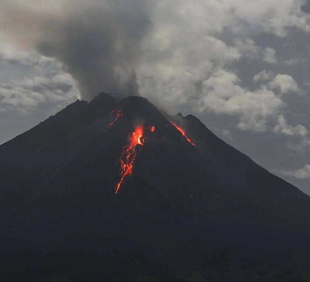
Indonesia , Merapi :
MOUNT MERAPI ACTIVITY REPORT, March 15 – 21, 2024
OBSERVATION RESULT
Visual
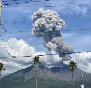
The weather around Mount Merapi is generally clear in the morning and night, while it is foggy from noon to evening. White smoke, fine to thick, low to moderate pressure and 50 m high was observed from the observation post of Mount Merapi in Kaliurang on January 17, 2024 at 05:40 WIB.
This week, lava avalanches were observed 59 times towards the South-West (upstream of the Bebeng River) up to a maximum of 1,800 m. The sound of an avalanche was heard once from the Babadan post with little intensity.
It was observed that the morphology of the southwest dome had changed due to lava avalanche activity. The highest hot spot was observed at 247.4°C, lower than the previous measurement temperature. The morphology of the median dome is relatively constant. The hot spot was observed at 207.3°C, lower than the previous measurement temperature. Based on the analysis of aerial photos dated March 21, 2024, the volume of the southwest dome was measured at 2,066,400 m3 and that of the central dome at 2,358,000 m3.
Seismicity
This week, the seismicity of Mount Merapi recorded
2 shallow volcanic earthquakes (VTB),
14 multi-phase (MP) earthquakes,
1 low frequency earthquake (LF),
335 avalanche earthquakes (RF),
6 tectonic earthquakes (TT).
The intensity of earthquakes this week is still quite high.
Deformation
The deformation of Mount Merapi monitored by EDM this week showed a shortening rate of 0.3 cm/day.
Rain and lahars
This week there was rain at Mount Merapi lookout post with a rain intensity of 19 mm/hour for 60 minutes at Babadan lookout post on March 17, 2024. No additional flow or lahar was reported in the rivers that have their source on Mount Merapi.
Conclusion
Based on the results of visual and instrumental observations, it was concluded that:
1. Mount Merapi’s volcanic activity is still quite high in the form of effusive eruptive activity. The activity status is set to the “SIAGA” level.
Source : BPPTKG
Photo : Andi Volcanist
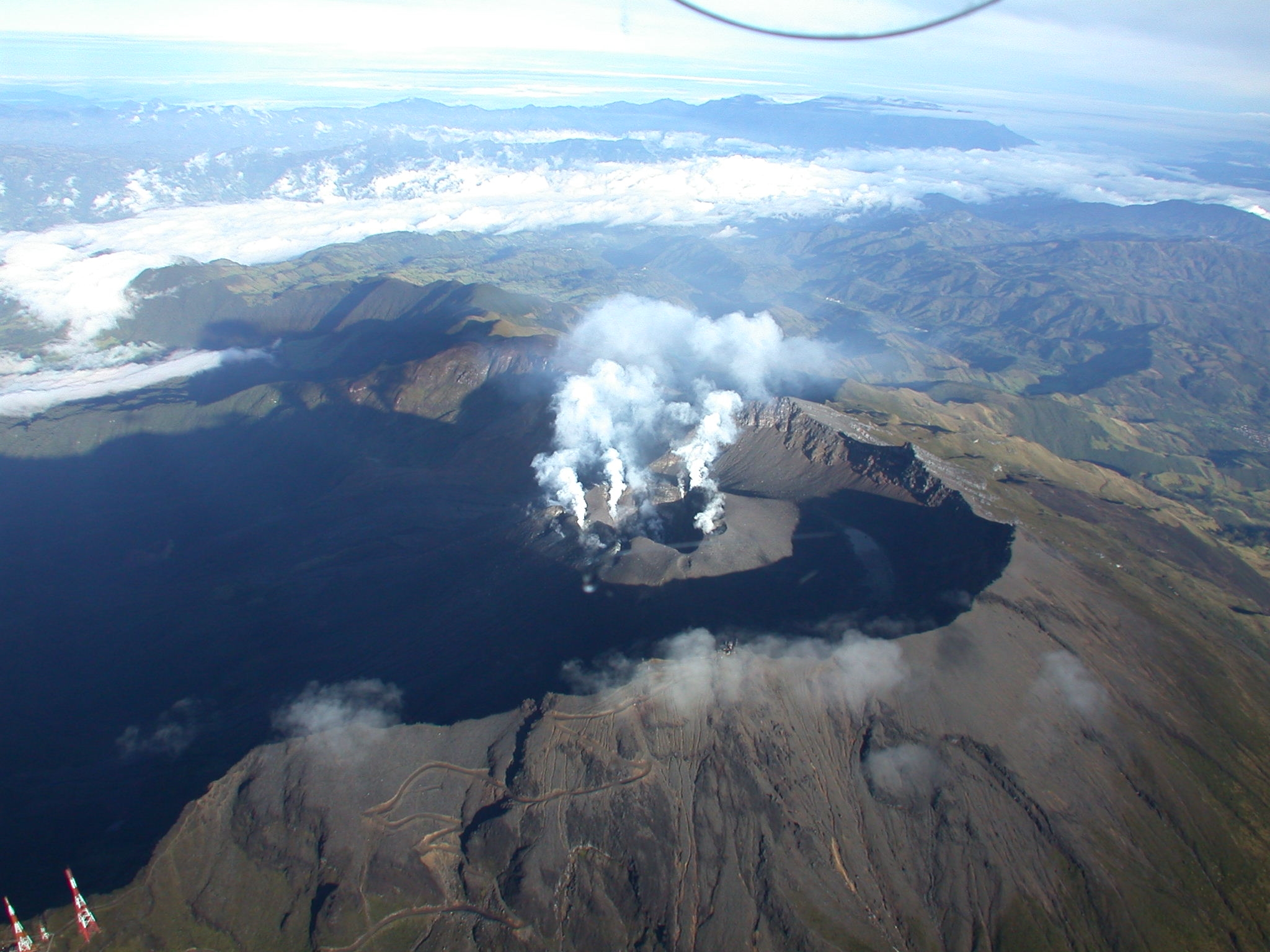
Alaska , Great Sitkin :
The eruption of lava within the summit crater of Great Sitkin Volcano continues. Partly cloudy satellite imagery showed steaming and elevated surface temperatures from the active lava flow. The active northwestern lava flow lobe that started in January 2024 is warm and mostly snow-free. Satellite radar data through March 19 showed growth of the northwest lava flow, as well as uplift of the lava flow surface above the vent region. Seismic activity remains relatively low with occasional small volcanic earthquakes.
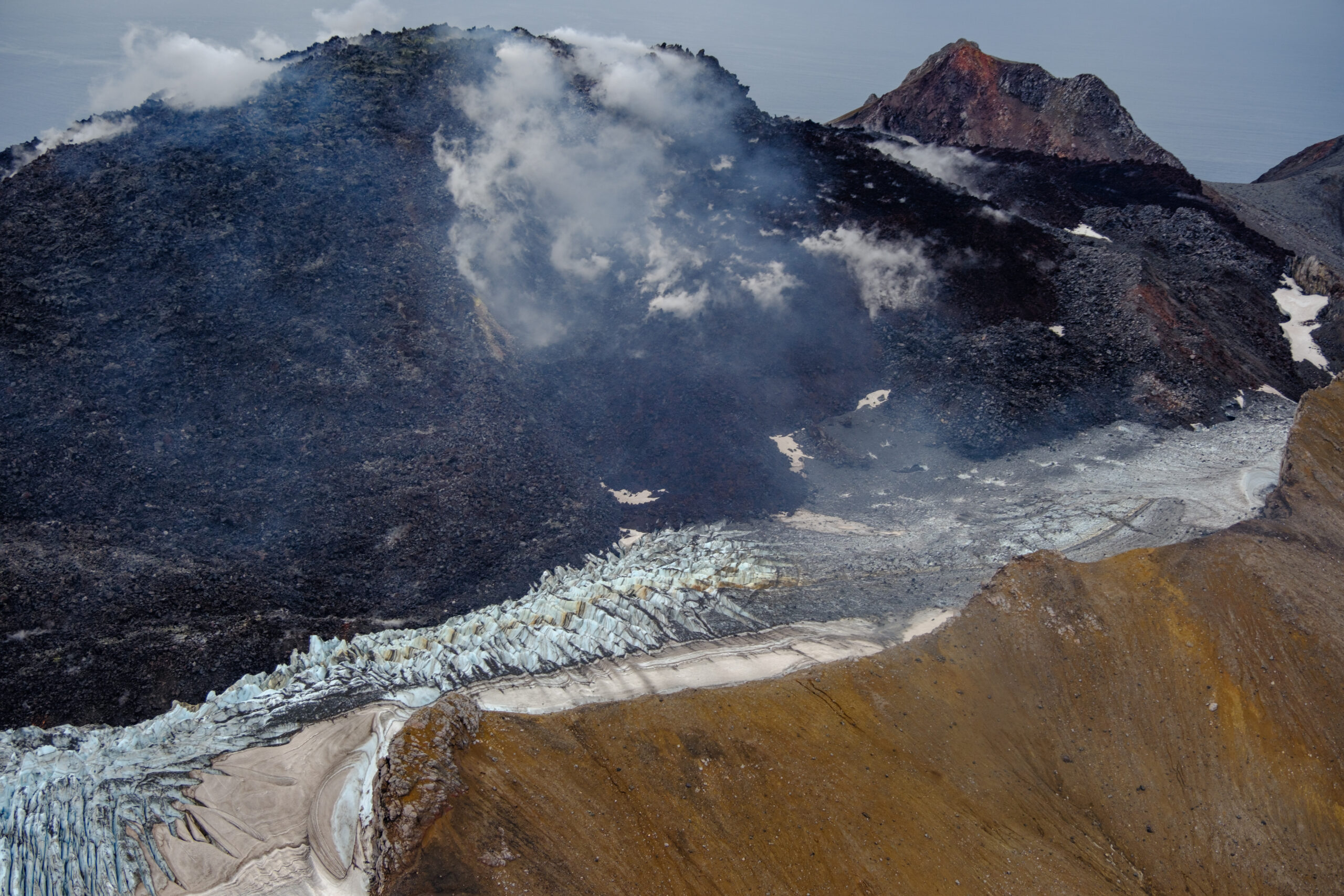
Great Sitkin Volcano on September 3, 2023, during helicopter approach for sampling efforts by AVO geologists. Image is looking west at the east margin of the summit flow field.
The current prolonged period of lava eruption at Great Sitkin Volcano began in July 2021. No explosive events have occurred since a single event in May 2021.
The volcano is monitored by local seismic, geodetic, and infrasound sensors and web cameras, as well as regional infrasound and lightning networks and satellite data.
Source : AVO
Photo : Loewen, Matt
Chile , Laguna del Maule :
Seismology
The seismological activity of the period was characterized by the recording of:
681 seismic events of type VT, associated with the fracture of rocks (Volcano-Tectonics). The most energetic earthquake had a Local Magnitude (ML) value equal to 2.6, located 3.2 km to the East-South-East relative to the center of the lagoon, at a depth of 7.6 km .
Fluid geochemistry
No anomalies have been reported in the emissions of sulfur dioxide (SO2) into the atmosphere in the area near the volcanic complex, according to data published by the Tropospheric Monitoring Instrument (TROPOMI) and the Ozone Monitoring Instrument (OMI) Sulfur Dioxide Group.
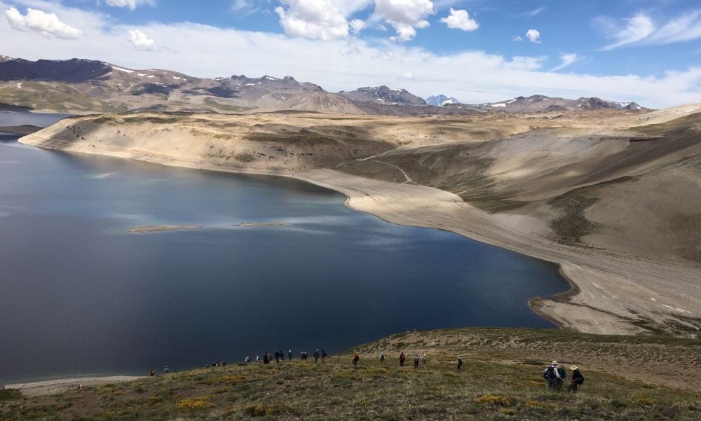
Geodesy
From data provided by 7 GNSS stations, which monitor deformation in the volcanic complex, we observe that the inflationary process recorded since 2012 continues,
particularly during the period evaluated, we note that:
– The distances between stations maintain the trends and magnitudes compared to the previous period, with lengthening or shortening rates which reach a maximum magnitude of 1.4 cm/month.
– The maximum vertical rise remains in the central sector of the lagoon, with a speed of 2.0 cm/month for this period, recorded at station MAU2.
– Through the use of the InSAR technique, using Sentinel 1A satellite images, signals associated with deformation of a magnitude and pattern similar to those previously recorded in the complex are observed, with an area maximum inflation near the center of the lagoon. In particular, for this period, a decrease in subsidence is observed east of Laguna Fea, in accordance with GNSS data.
The recording of VT type seismic activity continues recurrently, preferentially located to the South-West, East and South-East of the center of the lagoon. The process of cortical deformation continues to evolve at rates similar to those observed historically. On the surface, there are no apparent changes linked to volcanic dynamics. From the above, we conclude that the volcanic system always records internal activity with energy levels above its basic threshold. The technical alert is maintained in:
YELLOW TECHNICAL ALERT: Changes in the behavior of volcanic activity.
Source : Sernageomin
Photo : auteur inconnu
Colombia , Galeras :
Galeras Volcano Weekly Activity Bulletin
From the monitoring of the activity of the GALERAS VOLCANO, the MINISTRY OF MINES AND ENERGY through the COLOMBIAN GEOLOGICAL SERVICE (SGC) reports that:
For the period between March 12 and 18, 2024 and compared to previous weeks, a decrease in the number of events was observed, but with an increase in seismic energy. Earthquakes associated with fluid transit showed similar occurrence to events associated with rock fracture. The fracture earthquakes were located in a scattered manner in the volcanic region, at distances between 0.5 and 18 km, with depths between 0.5 and 13 km from its summit (4,200 m above sea level). ).
It is worth highlighting the earthquake that occurred on March 18 at 11:12 p.m., located 18 km northeast of Galeras, with a depth of 10 km and a magnitude of 2.4, which was reported as felt by the residents of different areas of the city of Pasto and other cities near the epicenter.
Gas emissions were recorded in the fumarole fields of Las Chavas, to the west, and El Paisita, to the north of the active cone, with white gas columns, of low height and variable dispersion due to the action of the winds.
Other volcanic monitoring areas showed stability in their recordings.
Volcanic activity remains on YELLOW ALERT Status: Active volcano with changes in baseline behavior of monitored parameters and other manifestations
Source et photo : SGC