March 20 , 2024.
Italy , Stromboli :
WEEKLY BULLETIN, from March 11, 2024 to March 17, 2024. (issue date March 19, 2024)
SUMMARY STATEMENT OF ACTIVITY
In light of the monitoring data, it appears:
1) VOLCANOLOGICAL OBSERVATIONS: Normal Strombolian activity was observed during this period. The total hourly frequency fluctuates between low (4 events/h) and medium (11 events/h) values. The intensity of the explosions was low and medium in the areas of the North and South Central craters.
2) SISMOLOGY: The monitored seismological parameters do not show significant variations.
3) GROUND DEFORMATIONS: The soil deformation monitoring networks do not show significant variations. A slight transient of approximately one microradian is reported between March 14 and 16 at the N185°E component.
4) GEOCHEMISTRY: SO2 flux at an average and decreasing level.
There are no updates for the CO2 flux in the summit area.
C/S ratio in the plume: there are no updates.
Helium Isotope Ratio in Thermal Aquifer: There are no updates.
CO2 flux in Scari: stable values at average levels.
5) SATELLITE OBSERVATIONS: Thermal activity observed by satellite was generally weak.
VOLCANOLOGICAL OBSERVATIONS
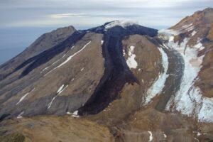
In the observed period, the eruptive activity of Stromboli was characterized through the analysis of images recorded by the INGV-OE surveillance cameras located at Pizzo (SPT), at altitude 190 m (SCT-SCV) and at Punta dei Corvi (SPCT). The explosive activity was mainly produced by 2 (two) eruptive vents located in the northern area of the crater and by 2 (two) vents located in the south central area. Due to unfavorable weather conditions on March 17, visibility of the crater terrace was insufficient for a correct description of the eruptive activity.
Observations of explosive activity captured by surveillance cameras
In the area of the North crater (N), with a mouth located in sector N1 and a mouth located in sector N2, explosive activity was observed mainly of low intensity (less than 80 m height) in sector N2 and low and medium intensity (less than 150 m height) in sector N1. The products emitted in the eruption were mainly coarse materials (bombs and lapilli). The average frequency of explosions fluctuated between 1 and 5 events/h.
In the South-Central (CS) zone, sectors C and S1 did not show significant activity. In sector S2 the explosions were of varying intensity ranging from low (less than 80 m in height) to medium (less than 150 m in height) emitting fine materials sometimes mixed with coarse materials. The average frequency of explosions varied between 2 and 6 events/h.
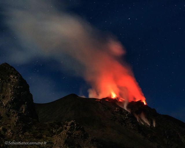
Source : INGV.
Photo : Stromboli stati d’animo / Sebastiano Cannavo. ( archive).
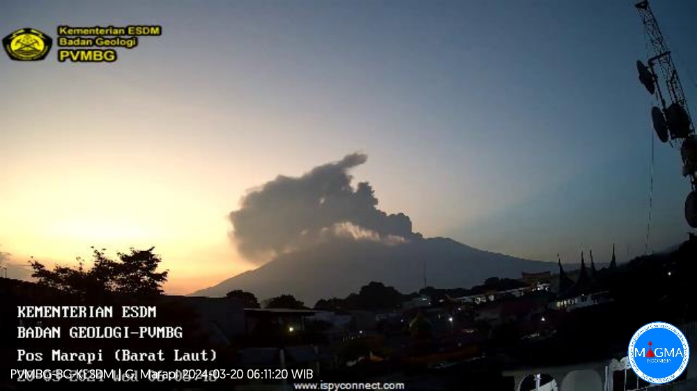
Indonesia , Marapi :
An eruption of Mount Marapi occurred on Wednesday, March 20, 2024 at 05:54 WIB with the height of the ash column observed at ±500 m above the summit (±3391 m above sea level). The ash column was observed to be gray with thick intensity, oriented towards the North. At the time of writing, the eruption was still ongoing.
SEISMICITY OBSERVATIONS:
69 emission earthquakes with an amplitude of 3.2 to 12.5 mm and earthquake duration of 25 to 318 seconds.
1 Low frequency earthquake with an amplitude of 1.7 mm and an earthquake duration of 18 seconds.
5 hybrid/multi-phase earthquakes with an amplitude of 3.5 to 8.1 mm, and the duration of the earthquake was 22 to 30 seconds.
2 Shallow volcanic earthquakes with an amplitude of 4.2 to 9.2 mm and an earthquake duration of 10 to 17 seconds.
7 deep volcanic earthquakes with an amplitude of 3.2 to 10.5 mm, and an earthquake duration of 8 to 21 seconds.
1 Distant tectonic earthquake with an amplitude of 8.2 mm, the duration of the earthquake was 96 seconds.
1 Continuous tremor with an amplitude of 0.5 to 3 mm, dominant value of 2 mm.
RECOMMENDATION
1. Communities around Mount Marapi and climbers/visitors/tourists should not enter and conduct activities within a 4.5 km radius of the eruption center (Verbeek crater) of Mount Marapi.
2. Communities living around the valleys/streams/river banks that originate at the summit of Mount Marapi should always be aware of the potential threat of lahar that may occur, especially during the rainy season.
Source et photo : Magma Indonésie.
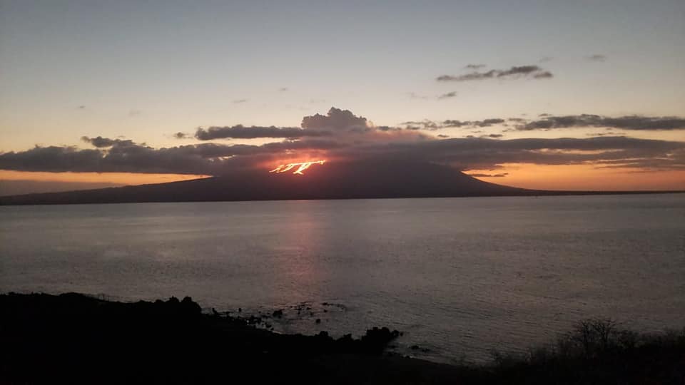
Colombia , Nevado del Ruiz :
Weekly activity bulletin: Nevado del Ruiz Volcano.
Regarding the monitoring of the activity of the NEVADO DEL RUIZ VOLCANO, the MINISTRY OF MINES AND ENERGY, through the COLOMBIAN GEOLOGICAL SERVICE (SGC), reports that:
In the week of March 12 to 18, 2024, the volcano continued with unstable behavior. Compared to the previous week, the main variations in parameters
monitored were:
– Seismicity linked to fluid dynamics within volcanic conduits has increased in the number of earthquakes recorded and maintained similar levels in seismic energy released. Most seismic signals were associated with pulsatile emissions of ash and gas into the atmosphere. Energy levels were low to moderate at times. Thanks to the cameras used to monitor the volcano, several ash emissions and some temperature changes of the emitted material associated with some of these seismic signals have been confirmed.
– Seismic activity associated with the fracturing of rocks within the volcanic edifice has maintained similar levels in the number of earthquakes recorded and decreased in the seismic energy released. The earthquakes were located mainly on the northeastern flank of the volcano, less than 4 km from the Arenas crater, and in the crater itself. To a lesser extent, certain earthquakes were located scatteredly on the other flanks of the volcano, up to maximum distances of 9 km from the crater. The depths of the events varied between less than 1 and 8 km from the volcano summit. The highest magnitude of the week was 1.3, corresponding to the earthquake of March 12 at 1:00 a.m., located 2 km northeast of the crater, with a depth of 4 km. During this week, the recording of seismicity linked to the activity of the lava dome (protuberance or mound) located at the bottom of the crater increased. Energy levels were low.
– The emission of water vapor and gas into the atmosphere continued at the volcano. Sulfur dioxide (SO2) outgassing rates were variable and maintained similar values to the previous week.

The maximum height of the gas or ash column was 1,200 m vertically and 1,500 m dispersed.
These values were measured at the summit of the volcano on March 17 during the emission of ash recorded at 3:09 a.m. mr. The predominant direction of dispersion of the column was towards the west-southwest and north-west flanks of the volcano.
– When monitoring surface activity from satellite monitoring platforms, several thermal anomalies were detected at the bottom of Arenas Crater with low to moderate energy levels. For this week, the cloudy conditions in the area did not favor its detection.
Source : SGC
Photos : SGC , Carlos Ortega.
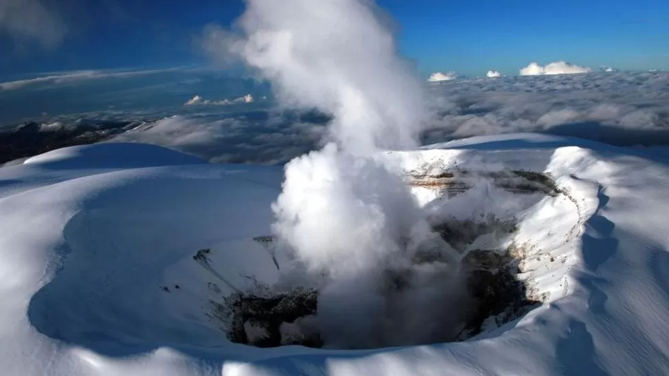
Ecuador / Galapagos Islands , Fernandina :
DAILY REPORT ON THE ACTIVITY OF THE FERNANDINA VOLCANO. Quito, Tuesday March 19, 2024.
From March 18, 2024 11:00:00 to March 19, 2024 11:00:00
Activity level:
Surface: Moderate; Surface trend: No changes
Internal: Moderate; Internal trend: No changes
Gas:
The Mounts satellite system detected 930.2 tons of sulfur dioxide (SO2) recorded yesterday at 1:42 p.m. TL.
Other monitoring parameters:
In the last 24 hours, the FIRMS satellite system recorded hundreds of thermal anomalies, in turn, the MIROVA-MODIS system recorded 2 moderate and 1 high thermal anomalies, while the MIROVA-VIIRS system recorded 1 anomaly high thermal.
Observation:
Since yesterday afternoon until the closing of this report, thanks to the monitoring of satellite images from the GOES-16 system, it has been observed that the presence of thermal anomalies continues in the volcano area. The volcano’s eruptive activity remains at a moderate level. It is important to note that Fernandina Island has no human settlements, so there is no risk to the population.
Source : IGEPN
Photo : Parque Nacional ( archive).
Mexico , Popocatepetl :
March 19, 11:00 a.m. (March 19, 5:00 p.m. GMT). Activity from the last 24 hours
83 exhalations were detected, accompanied by water vapor, volcanic gases and slight amounts of ash. Additionally, 507 minutes of very low to low amplitude high frequency tremors were identified, for a total of 8.44 hours.
In the early hours of today, light ash falls were recorded in the capital of Puebla, San Pedro Cholula, San Andrés Cholula, San Juan Cuautlancingo, Amozoc de Mota, all places in the state of Puebla.
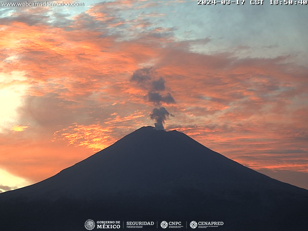
During the morning and at the time of this report, a continuous emission of water vapor and volcanic gases is observed, with dispersion towards the East-North-East (ENE).
The Popocatépetl volcanic warning fire is in yellow phase 2.
The scenarios planned for this phase are:
A few small to moderate explosions
Appearance of tremors of variable amplitude
Light to moderate ash rain in surrounding towns and some more distant towns
Ejection of incandescent fragments within the exclusion radius of 12 kilometers.
Source : Cenapred.