February 16 , 2024.
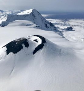
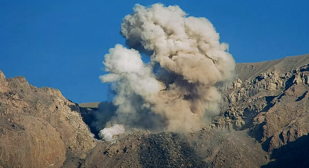
Alaska , Gareloi :
Unrest continues at Mount Gareloi with ongoing seismic tremor. No activity was observed in mostly cloudy satellite and webcam images over the past day
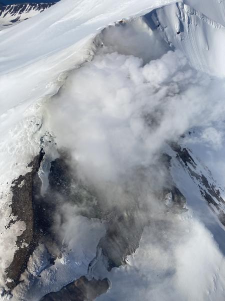
Mount Gareloi persistently emits magmatic gases from a fumarole field on the south crater and commonly exhibits low-level seismic activity. The current increase in seismicity likely reflects a change to the magmatic-hydrothermal system, but it is not clear that the likelihood of a volcanic eruption has increased. AVO will continue to monitor activity to determine if the recent changes are related to influx of new magma or other changes to the magmatic system.
Mount Gareloi is monitored by a local seismic and infrasound network, satellite data, and regional infrasound and lightning-detection networks.
Source : AVO
Photo : Jackson, Robert / Pathfinder Aviation.
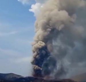
Indonesia , Semeru :
Mount Semeru exhibited an eruption on Thursday, February 15, 2024 at 06:28 WIB with the height of the ash column observed at ± 1000 m above the summit (± 4676 m above sea level). The ash column was observed to be white to gray in color with thick intensity, oriented towards the North-East. This eruption was recorded on a seismograph with a maximum amplitude of 22 mm and a duration of 101 seconds.
SEISMICITY OBSERVATIONS:
19 explosion/eruption earthquakes with an amplitude of 10 to 22 mm and a seismic duration of 83 to 130 seconds.
7 emission earthquakes with an amplitude of 3 to 8 mm and duration of the earthquake from 39 to 51 seconds.
VOLCANO OBSERVATORY NOTICE FOR AVIATION – VONA
Issued : February 15 , 2024
Volcano : Semeru (263300)
Current Aviation Colour Code : ORANGE
Previous Aviation Colour Code : orange
Source : Semeru Volcano Observatory
Notice Number : 2024SMR105
Volcano Location : S 08 deg 06 min 29 sec E 112 deg 55 min 12 sec
Area : East java, Indonesia
Summit Elevation : 11763 FT (3676 M)
Volcanic Activity Summary :
Eruption with volcanic ash cloud at 23h28 UTC (06h28 local).
Volcanic Cloud Height :
Best estimate of ash-cloud top is around 14963 FT (4676 M) above sea level or 3200 FT (1000 M) above summit. May be higher than what can be observed clearly. Source of height data: ground observer.
Other Volcanic Cloud Information :
Ash cloud moving to northeast. Volcanic ash is observed to be white to gray. The intensity of volcanic ash is observed to be thick.
Remarks :
Eruption recorded on seismogram with maximum amplitude 22 mm and maximum duration 101 second.
Source : Magma Indonésie.
Photo : Auteur inconnu
Chile , Villarica :
Special Report on Volcanic Activity (REAV), La Araucanía and Los Ríos regions, Villarrica volcano, February 14, 2024, 04:08 local time (mainland Chile)
The National Geology and Mining Service of Chile (Sernageomin) announces the following PRELIMINARY information, obtained through the monitoring equipment of the National Volcanic Monitoring Network (RNVV), processed and analyzed at the Southern Andean Volcano Observatory (Ovdas):
On Thursday, February 15, 2024, at 7:40 a.m. local time (10:40 UTC), monitoring stations installed near the Villarrica volcano recorded an earthquake associated with fluid dynamics inside the volcanic system (long-period type).
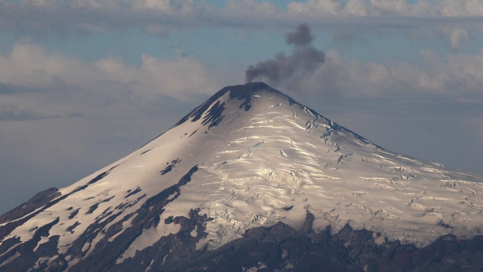
The characteristics of this earthquake after its analysis are as follows:
ORIGINAL TIME: 07:40 local time (10:40 UTC)
REDUCED TRAVEL: 70.2 (cm*cm)
ACOUSTIC SIGNAL: 7.2 Pascals (Pa) reduced to 1 km
Observation :
associated with this earthquake, no changes were recorded in the surface activity associated with this earthquake.
The technical volcanic alert is maintained at YELLOW level.
Source : Sernageomin
Photo : 24 horas
Colombia , Purace / Chaîne volcanique Los Coconucos :
Weekly bulletin of the activity of the Puracé volcano – Los Coconucos volcanic chain
From the monitoring of the activity of the VOLCANIC CHAIN PURACE VOLCANO – LOS COCONUCOS, the MINISTRY OF MINES AND ENERGY, through the COLOMBIAN GEOLOGICAL SERVICE (SGC), reports that:
During the week of February 6 to 12, 2024, seismic activity presented levels comparable to those of the previous week, both in energy and in number of events. The fracturing earthquakes were located mainly under the Puracé volcano, with depths less than 5 km and magnitudes less than 1.7 ML; while the earthquakes associated with the fluids were located in two areas, one under the crater of the volcano with depths less than 1 km and another to the South-East of it at depths between 1.5 and 5 km.
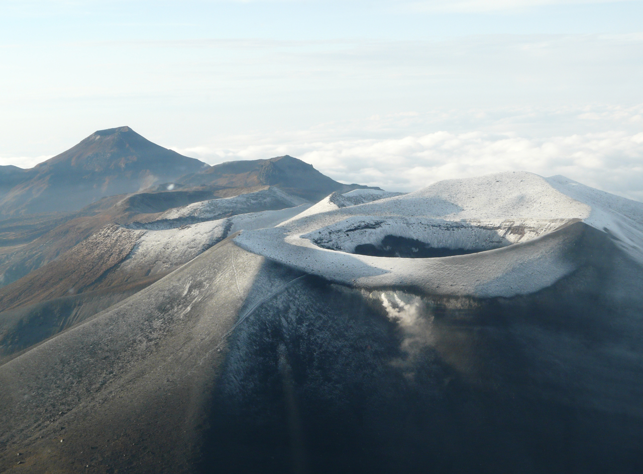
Likewise, localized deformations continued to be recorded between the Puracé and Curiquinga volcanoes. Carbon dioxide (CO2) values continue to oscillate and remain above reference values on this volcano. On the other hand, stable values were recorded in the sulfur dioxide (SO2) flux.
The images obtained using the installed cameras show that high degassing of the volcanic system is maintained, both inside the crater and in the external lateral fumarole (northwest flank of the volcanic edifice).
The other parameters measured and used for the diagnosis of volcanic activity showed no notable changes during the period evaluated.
The alert status for volcanic activity remains at: YELLOW ALERT: ACTIVE VOLCANO WITH CHANGES IN THE BEHAVIOR OF THE BASE LEVEL OF MONITORED PARAMETERS AND OTHER MANIFESTATIONS.
Source et photo : SGC
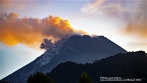
Guatemala , Fuego :
Weather conditions: Clear weather
Wind: South-East
Precipitation: 0.0 mm.
Activity:
The Observatory reports small, moderate and a few strong explosions, which occur at a rate of 1 to 4 per hour, raising columns of gas and gray ash to heights between 4,500 and 4,800 meters above the sea level (14,763 to 15,748 feet), which move variably northwest and west, carrying ash up to 20 kilometers or more. Due to wind direction, light falls of fine ash may occur on Yepocapa, Sangre de Cristo, Santa Emilia and Ojo de agua, among others.
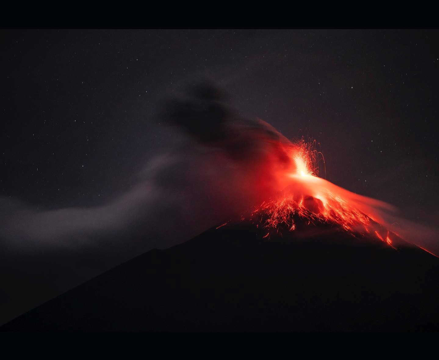
The explosions produce weak avalanches around the crater towards the Seca, Ceniza, Las Lajas, Honda and Taniluyá ravines where part of the ejected material reached the vegetation. A pulse of incandescent material, similar to a torch, was also observed up to 200 meters above the crater continuously during the night. The activity is accompanied by rumbling and weak shock waves. It must be taken into account that strong to moderate explosions expel ballistic projections towards the plateau and the ridge.
Source : Insivumeh.
Photo : Diego Rizzo