February 12 , 2024 .
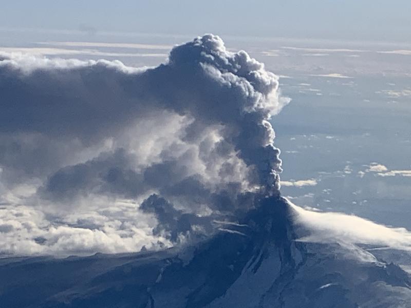
Alaska , Shishaldin :
AVO/USGS Volcanic Activity Notice
Current Volcano Alert Level: WATCH
Previous Volcano Alert Level: ADVISORY
Current Aviation Color Code: ORANGE
Previous Aviation Color Code: YELLOW
Issued: Sunday, February 11, 2024, 12:46 PM AKST
Source: Alaska Volcano Observatory
Notice Number: 2024/A152
Location: N 54 deg 45 min W 163 deg 58 min
Elevation: 9373 ft (2857 m)
Area: Aleutians
Volcanic Activity Summary:
Volcanic activity at Shishaldin Volcano has increased slightly, and minor ash emissions were observed in a web camera image from 18:25 UTC (9:25 AM) this morning. The ash in the web camera image extends from the summit crater and drapes down over the volcano’s north flank. This ash emission episode corresponds with seismic signals typically associated with surficial mass flows. The low-level ash cloud may result from a non-eruptive collapse of previously emplaced ash and pyroclastic debris on the upper part of the Shishaldin cone.
Clouds have obscured summit views in web camera images after the 18:25 UTC image. No ash clouds have been observed in satellite imagery. Thus, the Aviation Color Code and the Volcano Alert Level are being raised to ORANGE/WATCH.
Shishaldin Volcano is monitored by local seismic and infrasound sensors, web cameras, and a telemetered geodetic network. In addition to the local monitoring network, AVO uses nearby geophysical networks, regional infrasound and lighting data, and satellite images to detect eruptions.
Recent Observations:
[Volcanic cloud height] At summit (9375 ft)
[Other volcanic cloud information] Evident in ony 1 web cam image from 18:25 UTC
Hazard Analysis:
[Ashfall] Proximal flanks of the volcano
Remarks:
Shishaldin Volcano, located near the center of Unimak Island in the eastern Aleutian Islands, is a spectacular symmetric cone with a base diameter of approximately 10 miles (16 km). A 660 ft. (200 m) wide funnel-shaped summit crater typically emits a steam plume and occasional small amounts of ash. Shishaldin is one of the most active volcanoes in the Aleutian volcanic arc, with at least 54 episodes of unrest including over 26 confirmed eruptions since 1824. Most eruptions are relatively small, although the April-May 1999 event generated an ash column that reached 45,000 ft. (14 km) above sea level.
Source : AVO
Photo : Woodsen Saunders , avo ( archive)
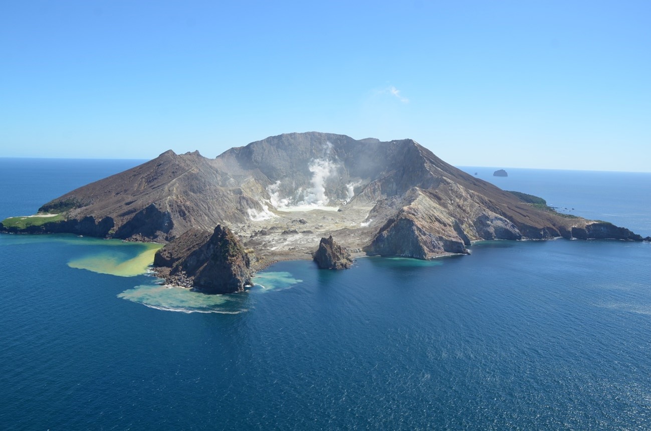
New Zealand , White Island :
Volcanic Activity Bulletin
Volcanic Alert Level remains at 2
Aviation Colour Code remains at Yellow
Recent gas and observation flights over Whakaari/White Island confirm the level of activity remains low. The primary surface activity is steam and gas emissions from the active vents with minor geysering in two craters. There is no evidence of any eruptive activity. The Volcanic Alert Level remains at 2.
Observations from the most recent observation flight on 7 February show that the steam and gas plumes continue to originate from the cluster of active fumaroles on the west-southwest shore of the main lake. Discharge rates are weakly elevated with respect to observations at the end of last year, but this is not considered significant. The main lake body remains a lime green colour, while the water level is slightly lower, still isolating a pool in the former 2019 crater. This pool and one immediately to the north are grey coloured as gas and minor geysering activity disturbs the sediments.
Steam and gas plumes can be seen above the island from the coast when local atmospheric conditions allow, and our Whakatāne web camera continues to record these. Based on these coastal observations and our regular flights, there has been no evidence of eruptive activity over the past few months. Satellite- based ground deformation data show no significant changes.
Measured gas emission rates from the gas flight on 24 January 2024 were elevated with respect to observations on 10 November 2013, but this is not considered significant as they remain within typical low-moderate values. Measurements from regular observation flights have recorded a general decline in the temperatures from the larger steam and gas vents through last year, however a small rise to 120 ºC was measured on the latest observation flight.
We will continue to make regular observation and gas measurement flights to monitor the status of the island. These are complemented by satellite-based ground deformation data approximately every 10 days, allowing us to observe ground deformation trends. We also get daily satellite-based sulphur dioxide (SO2) emission measurements, although this technique is not as sensitive as our gas measurement flights. Neither of these satellite techniques have detected significant changes in the overall activity at the volcano over the past few months.
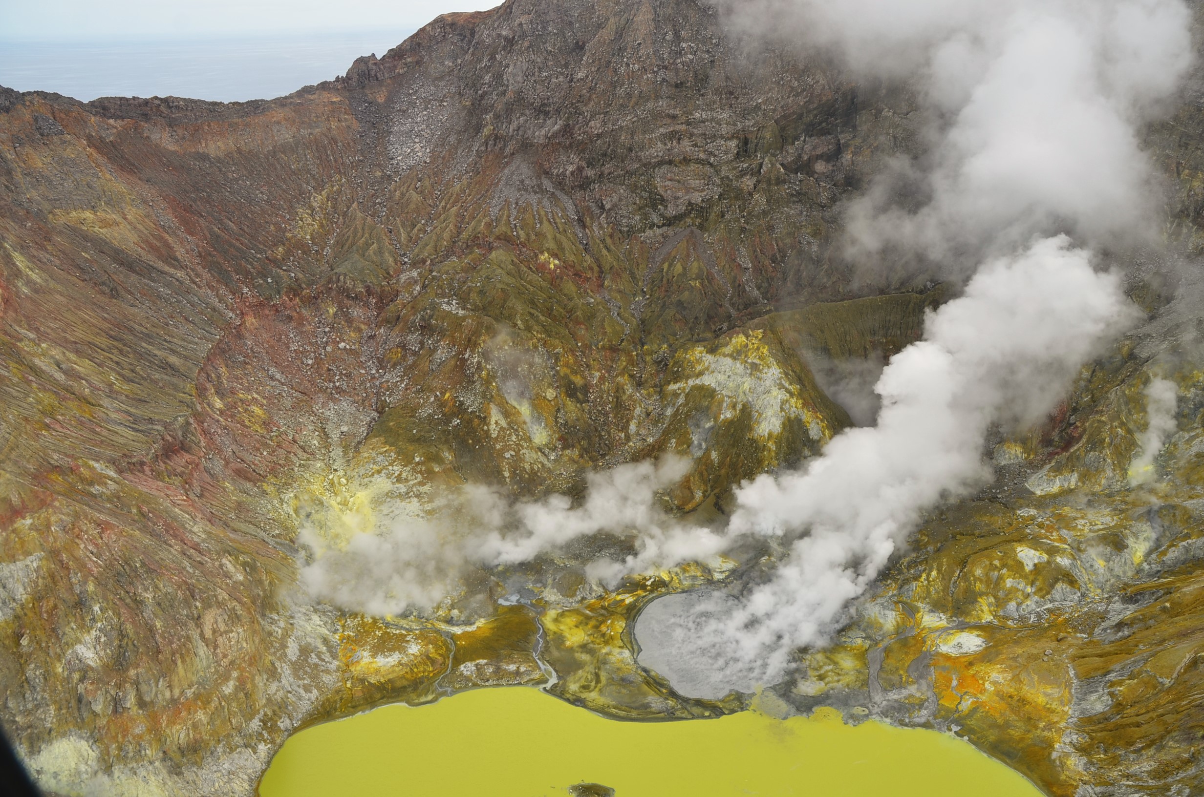
Aerial view of Whakaari/White Island, 7 February 2024 showing grey coloured pool in 2019 Crater (centre) now isolated from the lake and active steam and gas plumes from fumaroles.
The Volcanic Alert Level remains at Level 2 (moderate to heightened unrest) and the Aviation Colour Code remains at Yellow, acknowledging the current level of activity, but also continuing to consider the greater level of uncertainty in our interpretation due to the current lack of consistent, usable real-time data.
Source : Geonet / Duty Volcanologist: Brad Scott
Photos : Brad Scott, GNS Science.
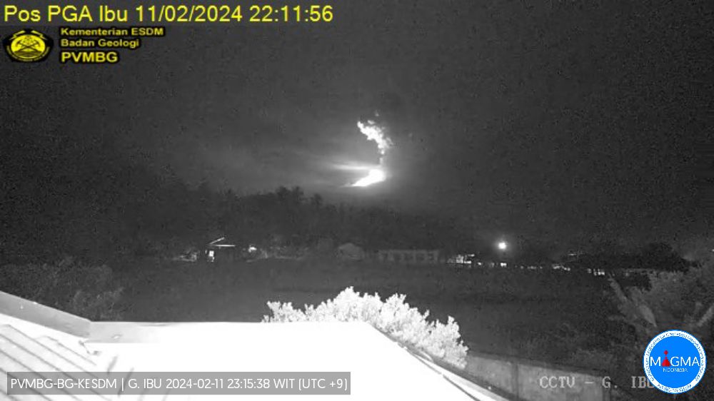
Indonesia , Ibu :
An eruption of Mount Ibu occurred on Sunday, February 11, 2024 at 10:10 p.m. WIT with the height of the ash column observed at ±1,200 m above the summit (±2,525 m above sea level) . The ash column was observed to be gray with thick intensity, oriented towards the South-West and West. This eruption was recorded on a seismograph with a maximum amplitude of 28 mm and a duration of 89 seconds.
SEISMICITY OBSERVATIONS
8 eruption/explosion earthquakes with an amplitude of 15 to 28 mm and a duration of 25 to 100 seconds.
38 emission earthquakes with an amplitude of 2 to 10 mm and duration of the earthquake from 8 to 40 seconds.
54 Shallow volcanic earthquakes with an amplitude of 2 to 12 mm and an earthquake duration of 8 to 12 seconds.
1 Distant tectonic earthquake with an amplitude of 28 mm, and the earthquake lasted 120 seconds.
RECOMMENDATION
Communities around Mount Ibu and visitors/tourists are advised not to carry out activities within a radius of 2.0 km and with a sectoral extension of 3.5 km towards the opening of the crater in the northern part of the active crater of Mount Ibu.
In the event of ash falling, people who practice activities outside the home are advised to wear nasal, oral (mask) and eye (glasses) protection.
Source et photo : Magma Indonésie .
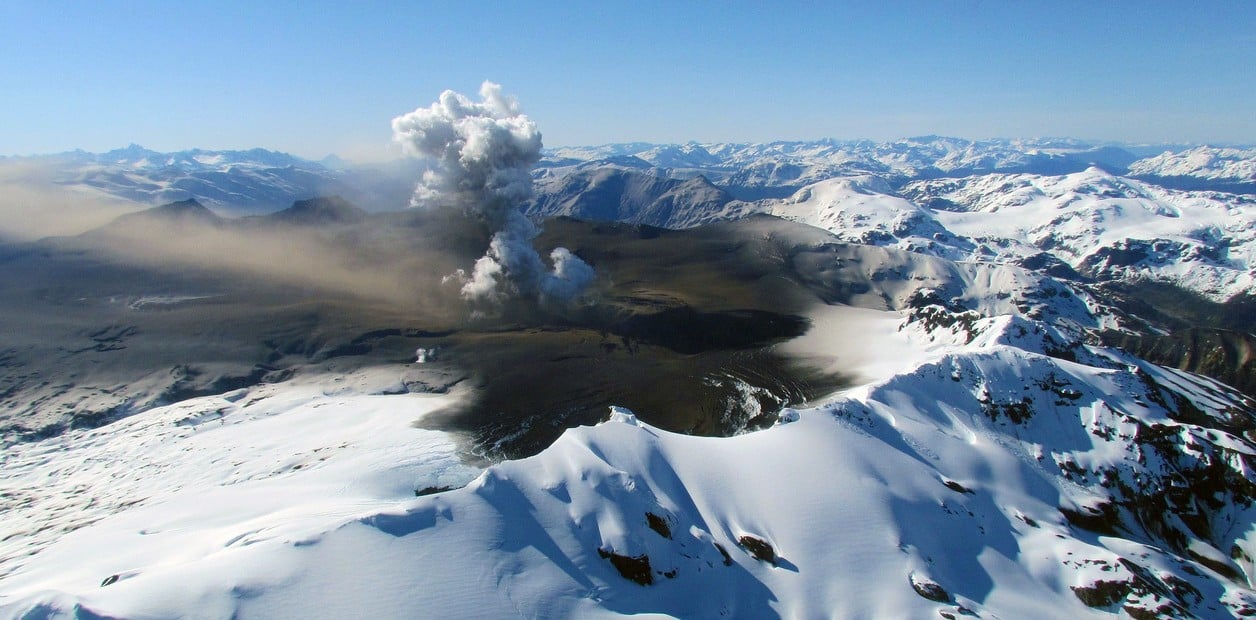
Chili , Hudson :
Seismology
The seismological activity of the period was characterized by the recording of:
41 seismic events of type VT, associated with the fracturing of rocks (Volcano-Tectonics). The most energetic earthquake had a Local Magnitude (ML) value equal to 1.1, located 6.4 km south-southeast of the volcanic building, at a depth of 4.7 km in reference to the crater.
395 LP type seismic events, associated with fluid dynamics inside the volcanic system (Long Period). The size of the largest earthquake evaluated from the Reduced Displacement (RD) parameter was equal to 25 cm2.
4 TR type seismic events, associated with the dynamics maintained over time of fluids inside the volcanic system (TRemor). The size of the largest earthquake evaluated from the Reduced Displacement (RD) parameter was equal to 3 cm2.
6 HB type seismic events, associated with both rock fracturing and fluid dynamics within the volcanic system (Hybrid). The size of the largest earthquake evaluated from the Reduced Displacement (RD) parameter was equal to 16 cm2.
Fluid geochemistry
No anomalies have been reported in the emissions of sulfur dioxide (SO2) into the atmosphere in the area near the volcano, according to data published by the Tropopheric Monitoring Instrument (TROPOMI) and the Ozone Monitoring Instrument (OMI) Sulfur Dioxide Group.
Satellite thermal anomalies
During the period, no thermal alerts were recorded in the area associated with the volcanic system, according to data processed by the Mid-Infrared Observation of Volcanic Activity (MIROVA). In addition, no radiance anomalies were reported thanks to the analytical processing of Sentinel 2-L2A satellite images, in combination of false color bands.
Geodesy
Geodetic activity was characterized by:
– Deformation rates of average magnitude, which do not exceed 0.8 cm/month in its horizontal components and 1.0 cm/month in its vertical components.
In conclusion, there is no evidence of changes following the deformation of the volcanic system.
Surveillance cameras
The images provided by the fixed camera, installed near the volcanic system, did not record degassing columns or variations linked to surface activity.
Activity remained at levels considered usual, suggesting stability of the volcanic system. The technical volcanic alert is maintained in:
GREEN TECHNICAL ALERT: Active volcano with stable behavior – There is no immediate risk
Source : Sernageomin
Photo : Clarin
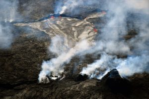
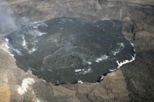
Hawaii , Kilauea :
Sunday, February 11, 2024, 9:32 AM HST (Sunday, February 11, 2024, 19:32 UTC)
19°25’16 » N 155°17’13 » W,
Summit Elevation 4091 ft (1247 m)
Current Volcano Alert Level: ADVISORY
Current Aviation Color Code: YELLOW
Activity Summary:
Kīlauea volcano is not erupting. Seismicity at the summit and along the Koa‘e fault system southwest of the summit continues following an intrusion of magma into the area over a week ago. The M5.7 earthquake near Pāhala on 9 February has not affected volcanic activity at Kīlauea.
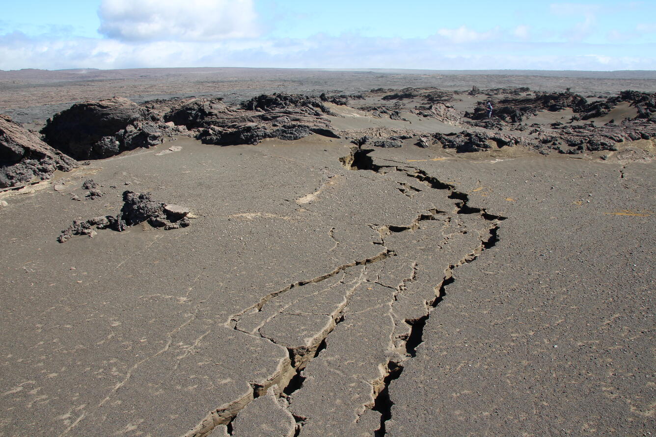
On February 3, 2024, a team of HVO scientists documented new ground cracks in three areas of the Maunaiki Trail in the Ka‘ū Desert, caused by the intrusion at Kīlauea south of the summit caldera. These cracks primarily cut the loose Keanakāko‘i tephra which blanketed the region in 1790 CE. Some cracks were over 100 feet (30 meters) long. Note the person for scale in the right upper portion of the photo.
Summit Observations:
Seismicity beneath the summit and extending 5-7 miles (8-11 km) southwest of the caldera under the Koa‘e fault zone continues. Earthquake counts have been holding steady at 1–10 earthquakes per hour; dispersed widely from the summit to the southwest. There were approximately 42 earthquakes recorded across this region over the past 24 hours. Depths remain consistent, typically 1–5 km (0.6-3 mi) below the surface, and magnitudes have generally decreased to below M1.5.
Ground deformation has slowed with tiltmeters near Sand Hill and Uēkahuna bluff have recording little change (less than 2 microradians) in the past few days.
Sulfur dioxide (SO2) gas emission rates have remained low since October 2023. An SO2 emission rate of approximately 70 tonnes per day was recorded on January 17.
Rift Zone Observations:
Seismicity in Kīlauea’s upper East Rift Zone and Southwest Rift Zone remain low. No unusual activity has been noted along the middle and lower sections of Kīlauea’s East Rift Zone. We continue to closely monitor both rift zones.
Source : HVO
Photo : USGS / N. Deligne.