May 19 , 2022.
Iceland , Reykjanes Peninsula :
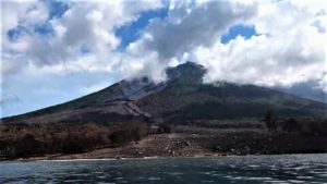
Over 4000 earthquakes were detected by the SIL seismic network this week. Around 1300 of them have been manually located. The largest earthquake of the week was of magnitude M4.8 at 16:56 on May 14th. It was felt widely in the southwestern part of the country. Considerable seismic activity was in the Reykjanes peninsula this week and a few short swarms with quite a few earthqaukes above M3.0 were detected. The largest earthquakes in the peninsula were of magnitude M4.3 and M4.2 in Eldvörp in a swarm that started on May 15th. Deformation data suggest a magma intrusion by Mt. þorbjörn and the seismic activity around it is still ongoing and often intense. On May 10th an earthquake of magnitude M3.2 was detected east of GrÃmsey. Six earthquakes were detected in Bárøarbunga and one in Öræfajökull.
An earthquake swarm started by Eldvörp on Reykjanes on May 15. Around 600 earthquakes were detected in the Reykjanes peninsula yesterday (18.th of May). The largest earthquake was a M3.5 at 04:27.
Landslides can occur in slopes and mountain sides when earthquakes of these magnitudes occur. Caution is advised for people in those areas.
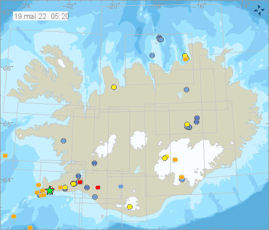
The National Commissioner of the Icelandic Police declared a level of “uncertainty” for the Reykjanes Peninsula on 15 May, noting that the declaration meant that responders and agencies were to review their preparedness plans in response to recent increases in seismicity and deformation. IMO raised the Aviation Color Code for Reykjanes to Yellow on 16 May, stating that more than 3,000 earthquakes had been detected near Eldvörp in the Reykjanes/Svartsengi volcanic system during the past week. Nine earthquakes above M 3 and two earthquakes above M 4 were recorded during 15-16 May; the largest event was a M 4.3 which was recorded at 1738 on 15 May. The earthquakes were located at depths of 4-6 km. GPS and InSAR data detected inflation W of Thorbjörn during the previous two weeks, likely caused by a magmatic intrusion at 4-5 km depth.
Sources : Vedur Is , GVP.
Photos : Arian Zwegers ( Thorbjörn ) , Vedur is .
Italy , Vulcano :
WEEKLY BULLETIN, from May 09, 2022 to May 15, 2022. (issue date May 17, 2022)
ACTIVITY STATUS SUMMARY
In the light of the surveillance data, it is highlighted:
1) Temperature of the crater fumaroles: Maximum stable emission temperatures around 380°C
2) CO2 flux in the crater area: The CO2 flux from the ground in the summit area is not available due to technical problems at the station, which are currently being resolved.
3) SO2 flux in the crater area: SO2 flux at a medium-high level and decreasing
4) Geochemistry of fumarolic gases: The concentration of magmatic species (CO2, He, N2) is slightly decreasing (13 mol% CO2 on 04/27/2022).
5) CO2 fluxes at the base of the La Fossa cone and in the Vulcano Porto area: The CO2 fluxes recorded in the C. Sicilia, Rimessa and P4max sites continue to show a slight downward trend, but remain on medium-high values; in the Faraglione site, there are values close to the background level.
6) Geochemistry of thermal aquifers: The physico-chemical parameters of thermal aquifers present stable or decreasing anomalies.
7) Local Seismicity: Local low level seismic activity.
8) Regional seismicity: There is no regional seismicity.
9) Deformations – GNSS: The network of permanent GNSS stations has not recorded any significant changes.
10) Deformations – Inclinometry: The inclinometric network has not recorded any significant changes.
11) Other observations: Gravimetry: No significant short-medium variation was recorded.
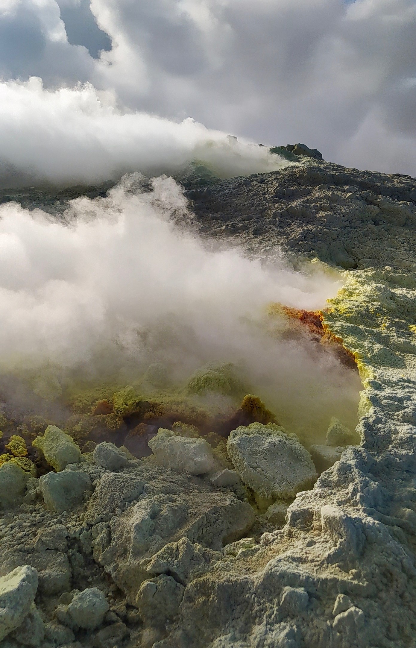
CRATER FUMEROLES TEMPERATURE.
Along the upper edge, the maximum emission temperature has very stable values (T1: 380-383°C), with a weekly average of 381°C (hourly data).
The fumarolic field has equivalent emission temperatures along the entire summit fracture line, confirming a thermal anomaly still maintained by a constant vapor flux.
The thermal signal from the sensor located on the interior side was interrupted on May 5, due to a power supply problem, but the site already showed obvious disturbances of an exogenous nature.
LOCAL SEISMICITY
The frequency of occurrence of micro-tremors with the spectral peak > 1 Hz during the week under consideration showed a variable trend with a low average occurrence rate.
As for low-frequency type events (VLP; spectral peak below 1 Hz), their rate of occurrence is low, and comparable to that of the previous week.
Source : INGV.
Photo : G. De Astis (INGV-Rome1)
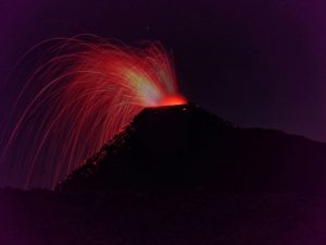
Alaska , Semisopochnoi :
51°55’44 » N 179°35’52 » E,
Summit Elevation 2625 ft (800 m)
Current Volcano Alert Level: WATCH
Current Aviation Color Code: ORANGE
Low-level eruptive activity continues. Seismicity remains elevated with intermittent tremor. Several explosions were detected in seismic and infrasound data over the last day. Clear satellite and web camera images showed low-level ash emissions. Satellite data also detected a sulfur dioxide plume extending 150 miles (240 km) northwest from the volcano.
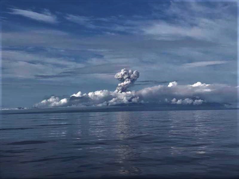
Small eruptions producing minor ash deposits within the vicinity of the active north crater of Mount Cerberus and ash clouds usually under 10,000 ft (3 km) above sea level have characterized the recent activity. Small explosions and associated ash emissions may continue and could be difficult to detect, especially when thick cloud cover obscures the volcano.
Semisopochnoi is monitored by local seismic and infrasound sensors, satellite data, web cameras, and remote infrasound and lightning networks.
Source : AVO
Photo : Rojek, Nora / R/V Tiglax .
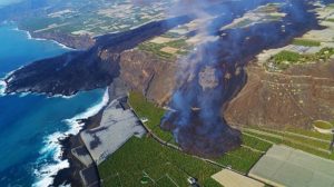
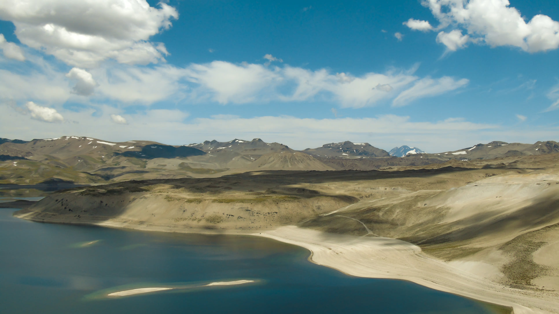
Chile , Laguna del Maule :
Special Report on Volcanic Activity (REAV), Region del Maule, Laguna del Maule Volcanic Complex, May 17, 2022, 8:30 p.m. local time (mainland Chile)
The National Geology and Mining Service of Chile (Sernageomin) publishes the following PRELIMINARY information, obtained through the monitoring equipment of the National Volcanic Monitoring Network (RNVV), processed and analyzed in the Volcanological Observatory of the Southern Andes (Ovdas) :
On Tuesday May 17, at 8:66 p.m. local time (00:06 UTC on May 18), the monitoring stations installed near the Laguna del Maule volcanic complex recorded an earthquake associated with the fracturing of the rock (volcano-tectonic type).
The characteristics of the earthquake after its analysis are as follows:
ORIGINAL TIME: 8:66 p.m. local time (00:06 UTC May 18)
LATITUDE: 36.1118°S
LONGITUDE: 70.5675°W
DEPTH: 6.6 km
LOCAL MAGNITUDE: 3.3 (ML).
Observations:
After the event, low energy volcano-tectonic aftershocks were recorded. There was no surface activity associated with this event.
The volcanic technical alert remains at the GREEN level.
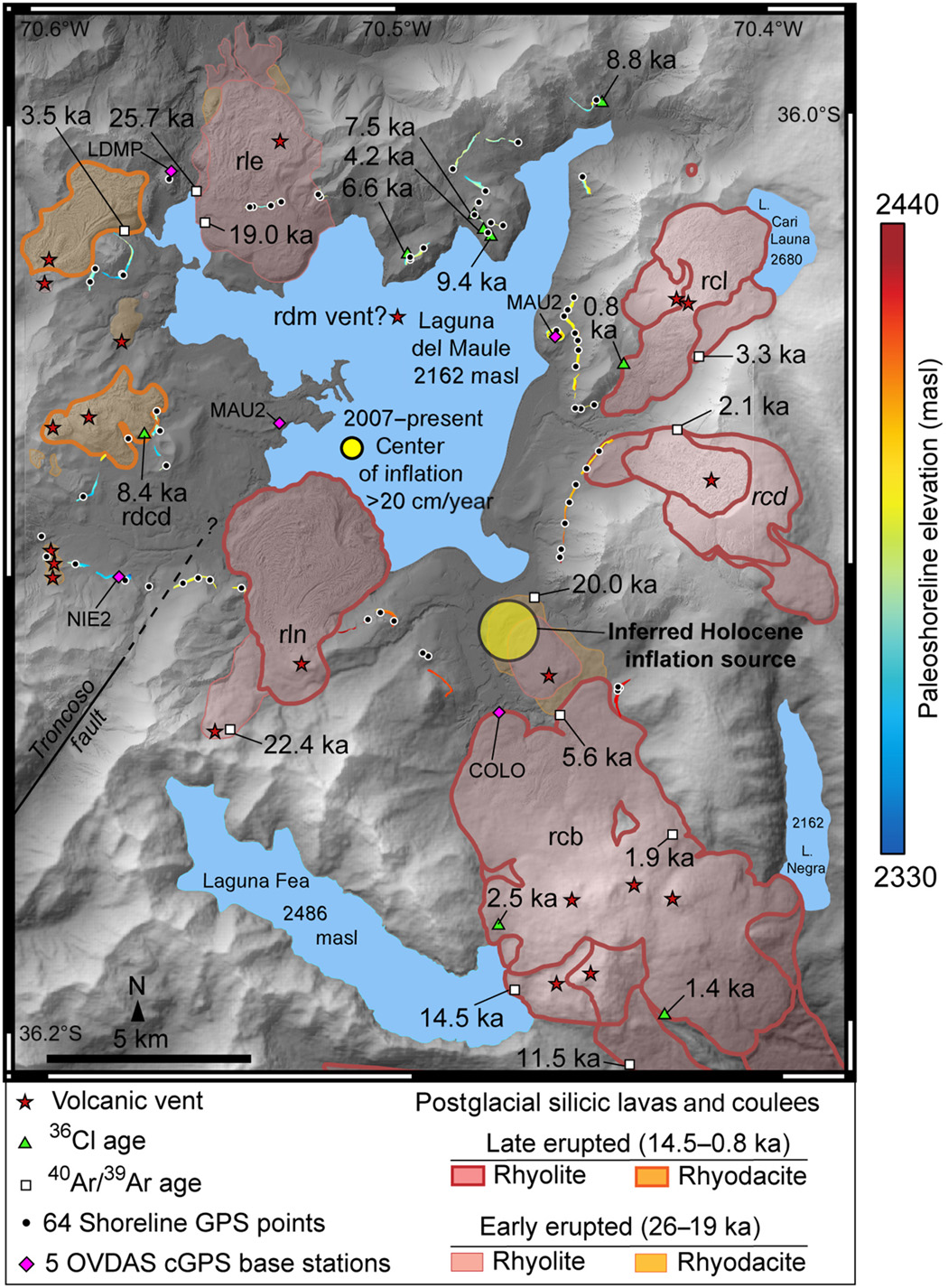
Geodesy
According to data obtained from the geodetic monitoring network installed in the complex (5 GNSS stations and 4 electronic inclinometers, IE), in addition to satellite radar interferometry (InSAR), it has been observed that the inflationary process monitored since 2012 continues , with growth rates slightly lower than the average recorded last year. For 30 days, the maximum uplift has continued to be recorded at the GNSS MAU2 station, in the southwestern sector of the lagoon, with a rate of 1.6 ±0.2 cm/month. The data obtained with the EI show variations without relevant trends. On the other hand, the Sentinel1 radar satellite images, processed using the radar interferometry technique (InSAR), in addition to presenting a very low coherence due to the heavy presence of snow in the sector, did not show significant variations in the deformation pattern.
Source : Sernageomin.
Photo : Franco Vera. science .org.
Japan , Suwanosejima :
JMA reported that eruptive activity continued to be recorded at Suwanosejima’s Ontake Crater during 9-16 May. Eruption plumes rose as high as 1 km above the crater rim and material was ejected 400 m above the vent; no explosions were recorded. Ash fell in Toshima village (3.5 km SSW) during 13-16 May. The Alert Level remained at 3 and the public was warned to stay 2 km away from the crater.
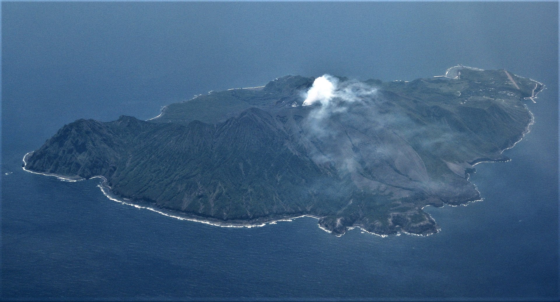
The 8-km-long, spindle-shaped island of Suwanosejima in the northern Ryukyu Islands consists of an andesitic stratovolcano with two historically active summit craters. The summit is truncated by a large breached crater extending to the sea on the east flank that was formed by edifice collapse. Suwanosejima, one of Japan’s most frequently active volcanoes, was in a state of intermittent strombolian activity from Otake, the NE summit crater, that began in 1949 and lasted until 1996, after which periods of inactivity lengthened. The largest historical eruption took place in 1813-14, when thick scoria deposits blanketed residential areas, and the SW crater produced two lava flows that reached the western coast. At the end of the eruption the summit of Otake collapsed forming a large debris avalanche and creating the horseshoe-shaped Sakuchi caldera, which extends to the eastern coast. The island remained uninhabited for about 70 years after the 1813-1814 eruption. Lava flows reached the eastern coast of the island in 1884. Only about 50 people live on the island.
Sources: Japan Meteorological Agency (JMA) , GVP.
Photo : Ray Go.
Hawaii , Kilauea :
19°25’16 » N 155°17’13 » W,
Summit Elevation 4091 ft (1247 m)
Current Volcano Alert Level: WATCH
Current Aviation Color Code: ORANGE
Activity Summary:
The summit eruption of Kīlauea Volcano, within Halemaʻumaʻu crater, continued over the past 24 hours. All recent lava activity has been confined to the crater, and current data indicate that this scenario is likely to continue. No significant changes have been noted in the summit or East Rift Zone.
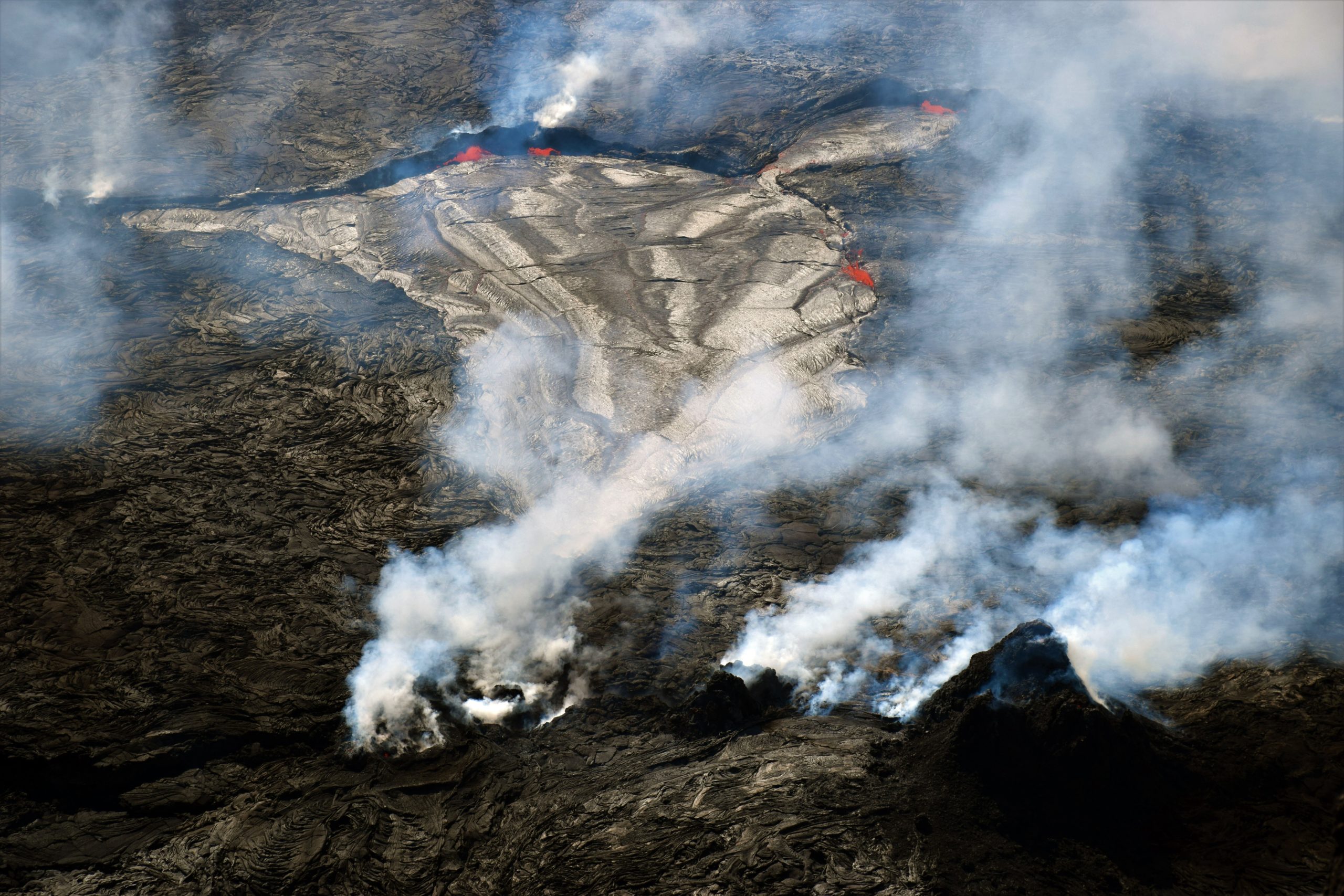
A telephoto image of the west vent (lower right) and active lava lake in Halema‘uma‘u, the crater within Kīlauea volcano’s summit caldera. Spattering lava is visible around the eastern (top) and southern (upper right) lake margins. The lava lake is approximately 168 m (551 ft) east-west (top to bottom), and 60 m (197 ft) north-south (left to right). The height of the tallest west vent cone is about 26 m (85 ft).
Halemaʻumaʻu crater Lava Lake Observations:
Eruption of lava from the Halemaʻumaʻu western vent into the active lava lake and onto the crater floor has continued over the past 24 hours. The active lava lake has shown continuous surface activity, with lake level remaining relatively high, with some minor fluctuations in level. Few to no ooze-outs were observed in the last 24 hours. Overflight measurements on May 10, 2022 indicated that the crater floor had seen a total rise of about 106 meters (348 feet) .
Summit Observations:
Summit tiltmeters showed gradual deflation over the past 24 hours. A sulfur dioxide (SO2) emission rate of approximately 2,800 tonnes per day (t/d) was measured on May 12, 2022.
Source : HVO.
Photo : USGS / L. DeSmither May 11, 2022.