January 04 , 2024 .
United-States , Yellowstone :
Tuesday, January 2, 2024, 11:04 AM MST (Tuesday, January 2, 2024, 18:04 UTC)
44°25’48 » N 110°40’12 » W,
Summit Elevation 9203 ft (2805 m)
Current Volcano Alert Level: NORMAL
Current Aviation Color Code: GREEN
Recent Work and News
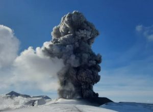
Steamboat Geyser erupted on December 30—its 9th major water eruption of 2023.
Seismicity
During December 2023, the University of Utah Seismograph Stations, responsible for the operation and analysis of the Yellowstone Seismic Network, located 89 earthquakes in the Yellowstone National Park region. The largest event of the month was a minor earthquake of magnitude 2.1 located about 3 miles northeast of West Thumb in Yellowstone National Park on December 16 at 8:19 PM MST.
December seismicity in Yellowstone was marked by three swarms:
1. A swarm of 16 earthquakes, located approximately 4 miles northeast of West Yellowstone, MT, occurred December 8–14. The largest earthquake in the sequence was a magnitude 1.7 event on December 11 at 11:59 PM MST.
2. A swarm of 14 earthquakes occurred approximately 3 miles northeast of West Thumb, in Yellowstone National Park, during December 16–17. The largest earthquake in the sequence was also the largest of the month (described above).
3. An ongoing swarm, approximately 12 miles south of West Thumb, in Yellowstone National Park, began on December 29. 11 earthquakes occurred during December 29–31. The largest earthquake in the sequence was a magnitude 1.9 event on December 29 at 9:37 PM MST.
Earthquake sequences like these are common and account for roughly 50% of the total seismicity in the Yellowstone region.
Yellowstone earthquake activity is currently at background levels.
Ground Deformation
During the month of December, continuous GPS stations in Yellowstone caldera showed subsidence, which has been ongoing since 2015, interrupted in summer months by a pause or slight uplift caused by groundwater accumulation from snowmelt and runoff. Approximately 2 cm (0.8 in) of subsidence has occurred in the caldera since the end of September. No significant deformation has occurred at Norris Geyser Basin since the end of summer.
Source : YVO
Photo : Sara Peek
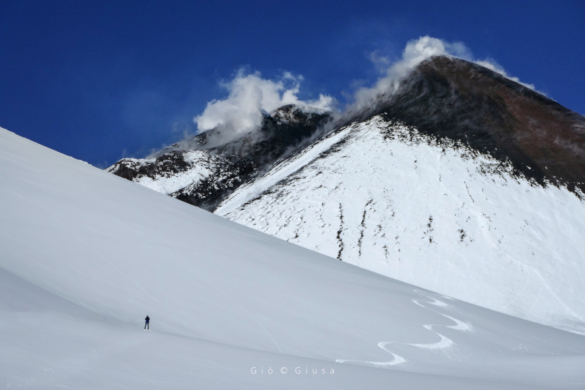
Italy / Sicily , Etna :
WEEKLY BULLETIN, from December 25, 2023 to December 31, 2023. (issue date January 2, 2024)
SUMMARY STATEMENT OF ACTIVITY
In light of the monitoring data, it appears:
1) VOLCANOLOGICAL OBSERVATIONS: Degassing activity at the Bocca Nuova Crater (BN) and the South-East Crater (CSE).
2) SEISMOLOGY: Low seismic activity due to fracturing; stationarity of volcanic tremor parameters.
3) INFRASOUND: Moderate activity, the sources were located in correspondence with the Bocca Nuova crater.
4) GROUND DEFORMATIONS: Over the past week, ground deformation monitoring networks have not recorded any significant changes.
5) GEOCHEMISTRY: The SO2 flux in the plume is at average values
Soil CO2 fluxes are at average values
Partial pressure of CO2 dissolved in groundwater shows values within seasonal variability
There are no updates to the helium isotope ratio
6) SATELLITE OBSERVATIONS: Thermal activity observed by satellite was generally low level with rare and isolated anomalies of moderate level.
VOLCANOLOGICAL OBSERVATIONS
During the week, monitoring of the volcanic activity of Etna was carried out through the analysis of images from the surveillance cameras of the INGV, Osservatorio Etneo (INGV-OE). Adverse weather conditions limited remote observation of volcanic activity only on 12/31. During the remainder of the period, occlusions due to cloud cover were limited
During the period examined, the activity of Etna was characterized by variable degassing activity at the level of the Bocca Nuova crater (BN) and the Southeast crater (CSE), while the crater of the Voragine (VOR) and the North-East East crater (CNE) remain obstructed. presenting limited gas releases produced by small fumaroles.
Source : INGV
Photo : Gio Giusa
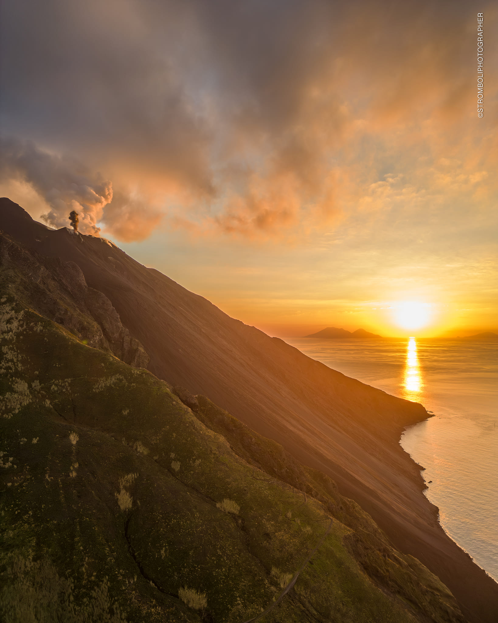
Italy , Stromboli :
WEEKLY BULLETIN, from December 25, 2023 to December 31, 2023. (issue date January 2, 2024)
SUMMARY STATEMENT OF ACTIVITY
In light of the monitoring data, it appears:
1) VOLCANOLOGICAL OBSERVATIONS: Ordinary explosive volcanic activity of the Strombolian type coupled with splashing and a major explosion on December 30. The frequency of total explosive activity was medium level with low to medium intensity in the North Crater area. and between low and high in the Center-South zone.
2) SEISMOLOGY: The monitored seismological parameters do not show significant variations, with the exception of the major explosive sequence recorded on 12/30.
3) GROUND DEFORMATIONS: The ground deformation monitoring networks did not show significant variations over the period under examination.
4) GEOCHEMISTRY: SO2 flux at medium level
CO2 flux in the summit zone, increasing values, high values
C/S ratio in the plume there are no updates: on medium-high values (last measurement of 11/19/2023)
The helium isotope ratio in the thermal aquifer increases to high-very high values. (last collection on December 11, 2023)
CO2 flow in Scari: the data continues to remain at average values, increasing.
5) SATELLITE OBSERVATIONS: Thermal activity observed by satellite was generally weak.
VOLCANOLOGICAL OBSERVATIONS
During the observed period, the eruptive activity of Stromboli was characterized thanks to the analysis of images recorded by the network of INGV-OE surveillance cameras on the visible and thermal (elevations 190m, 400m and Punta Corvi). Overall, the eruptive activity consisted of classic ordinary explosive activity coupled with a major event produced by the South Central Crater area.
Regarding the ordinary explosive activity, this was produced by an eruptive vent located in the area of the N1 crater and by two in the area of the N2 crater, while in the area of the Center-South crater, the activity was produced by two vents located in sector S2; the vents located in sectors S1 and C did not show eruptive activity but only degassing. The average/daily frequency of total explosive activity produced by the two crater areas remained at an average level. The component of erupted products was variable but mainly coarse materials (bombs/lapilli) mixed with fine materials (ashes) in both areas of the crater. The intensity of the explosive activity was between a low and medium level and between low and high, respectively in the North and Central-South zones. The projection activity observed in previous weeks continued with a variable regime over the entire period at the N2 vent of the North zone and between the 27th and the 30th at the S2 vent of the CS zone. .
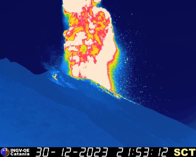
Ordinary explosive activity on December 30 was interrupted by an explosive event classified as the largest produced by the South Central Crater area. The event developed as a sequence of 6 explosions which occurred between 9:52.58 p.m. and 9:57.28 p.m. (GMT) and lasted a total of approximately 4 minutes and 30 seconds. In detail by order of energy associated with the explosions and the eruptive event, the sequence was characterized by the appearance of the major explosion at 9:52.58 p.m., by another non-major event but with energy greater than the regular at 9:54:15 p.m., and finally for a final prolonged explosive transient with fountain characteristics lasting approximately 40 seconds between 9:55:53 and 9:57:28. These main eruptive manifestations of the sequence were interspersed with four other ordinary explosions occurring at 21:53:20, 21:53:40, 21:54:54 and 21:55:44.
The major explosion had a vertical development during which it produced significant fallout of pyroclastic products out of the crater terrace which flowed along the Sciara del Fuoco.
Source : INGV.
Photos : Stromboli Stati d’animo . INGV.
Indonesia , Gamalama :
Press release on the activity of G. GAMALAMA LEVEL II (WASPADA).
Geographically, the Gamalama volcano in the north of the Moluccas is located at 0°48′ N and 127°19′ E with a height of 1715 m above sea level. Administratively, it includes the city area from Ternate, in the province of North Moluccas. Mount Gamalama is an active volcano with a recorded eruption history since 1538 with an eruption interval of between 1 and 50 years. Mount Gamalama is monitored visually and instrumentally from the Volcano Observation Post (PGA) located in Ternate Town, North Moluccas.
The seismicity of Mount Gamalama since January 2023 is dominated by distant tectonic earthquakes, local tectonic earthquakes and deep volcanic earthquakes (VA). Deep volcanic earthquakes (VA) are generally recorded at 2 to 3 events per day. The smoke escaping from the crater is generally observed to be white, weak to thick, at a height of 5 to 300 meters above the summit. The current activity level has been at Level II (WASPADA) since March 10, 2015. The character of the eruption generally occurs in the central crater with relatively short eruption precursors. The last eruption took place on October 4, 2018, beginning with the recording of 7 volcanic earthquakes in the hour before the eruption. The height of the eruptive column reached 250 meters from the summit.

The latest developments on G. Gamalama’s activities until January 4, 2024 at 06:00 WIT are as follows:
There was a significant increase in deep volcanic (VA) earthquakes on January 4, 2024. Earthquake records on January 4, 2024 from 00:00 to 06:00 WIT recorded 45 deep volcanic earthquakes with an amplitude of 4 at 46mm. This increase in deep volcanic earthquakes shows an increase in pressure inside the body of Mount Gamalama due to increased magmatic activity, but so far no surface earthquakes have been recorded.
From December 1, 2023 to January 3, 2024, 34 emissions earthquakes, 57 deep volcanic earthquakes, 55 local tectonic earthquakes, 359 distant tectonic earthquakes and 6 lahar earthquakes were recorded.
Crater degassing activity was observed between December 1, 2023 and January 3, 2024, emitting fine white crater smoke from a height of 10 to 120 meters.
In general, the activity of Mount Gamalama from December 1, 2023 to January 4, 2024 at 06:00 WIT tends to fluctuate and is always dominated by deep volcanic earthquakes, local tectonic earthquakes, and distant tectonic earthquakes that are linked to regional tectonic activity around the Halmahera Islands.
Under conditions like those above, and given the characteristics of the precursors to the Mount Gamalama eruption, the potential hazard most likely to occur is a phreatic eruption with the current hazard in the form of material ejection from the main crater hitting an area. with a radius of 1.5 km around the center of the eruption. Light ash showers may occur with distance and intensity depending on wind direction and speed.
Based on the results of observations and analysis of visual and instrumental data, the activity level of Mount Gamalama is still at level II (WASPADA).
Source : PVMBG
Photo : IST
Japan , Suwanosejima :
JMA reported that the eruption at Suwanosejima’s Ontake Crater continued during 25 December 2023-1 January 2024. No explosions were detected, though large blocks were ejected as far as 300 m from the vent. Eruption plumes rose 1-1.6 km above the crater rim during 27-28 December, 30 December, and 1 January, and drifted SW, S, SE, and E. Ashfall was reported in Toshima village (3.5 km SSW), though dates were not specified. The Alert Level remained at 2 (on a 5-level scale) and the public was warned to stay at least 1 km away from the crater.
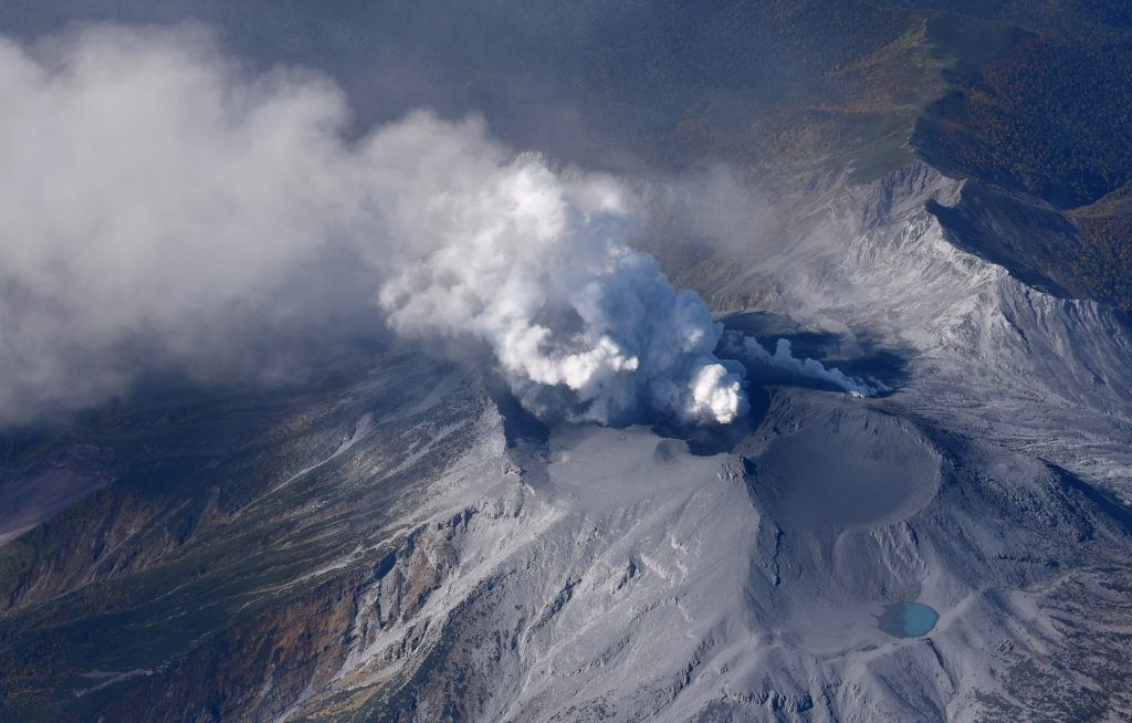
The 8-km-long island of Suwanosejima in the northern Ryukyu Islands consists of an andesitic stratovolcano with two historically active summit craters. The summit is truncated by a large breached crater extending to the sea on the east flank that was formed by edifice collapse. One of Japan’s most frequently active volcanoes, it was in a state of intermittent Strombolian activity from Otake, the NE summit crater, between 1949 and 1996, after which periods of inactivity lengthened. The largest recorded eruption took place in 1813-14, when thick scoria deposits blanketed residential areas, and the SW crater produced two lava flows that reached the western coast. At the end of the eruption the summit of Otake collapsed, forming a large debris avalanche and creating the open Sakuchi caldera, which extends to the eastern coast. The island remained uninhabited for about 70 years after the 1813-1814 eruption. Lava flows reached the eastern coast of the island in 1884. Only about 50 people live on the island.
Source : Agence météorologique japonaise (JMA), GVP.
Photo : Masanori Genko