January 02 , 2024.
Italy , Stromboli :
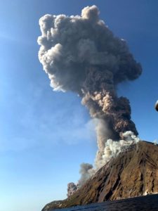
PRESS RELEASE ON THE ACTIVITY OF STROMBOLI. December 30, 2023, 11:16 p.m. (10:16 p.m. UTC).
The National Institute of Geophysics and Volcanology, Osservatorio Etneo, communicates that the monitoring networks recorded, at 9:53 p.m. UTC, a major explosion, immediately followed, at 9:54 p.m. UTC, by a second explosive event of less intensity. The explosions produced a significant emission of coarse pyroclastic material, the fallout of which affected the Sciara del Fuoco, with the hot material rolling down the slope.
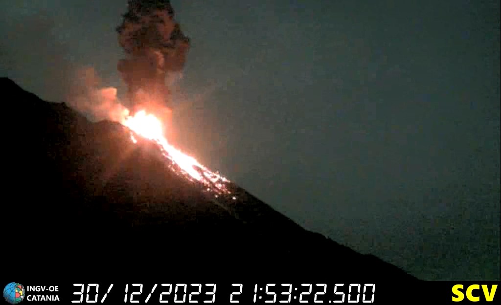
From a seismic point of view, it is worth highlighting that two explosive signals were recorded in rapid sequence, the first at 21:51:40 UTC and the second at 21:53. In the following minutes, until 22:00 UTC, the volcanic tremor remained slightly higher than previous values.
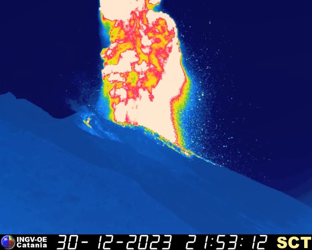
The analysis of ground deformations highlights a transient of approximately 0.4 microradians at the Timpone del Fuoco inclinometer station coinciding with the explosion (between 9:52 p.m. and 9:53 p.m. UTC); the signal immediately returned to its previous values immediately after the explosive event.
Further updates will be communicated shortly.
Source : INGV.
Photos : INGV
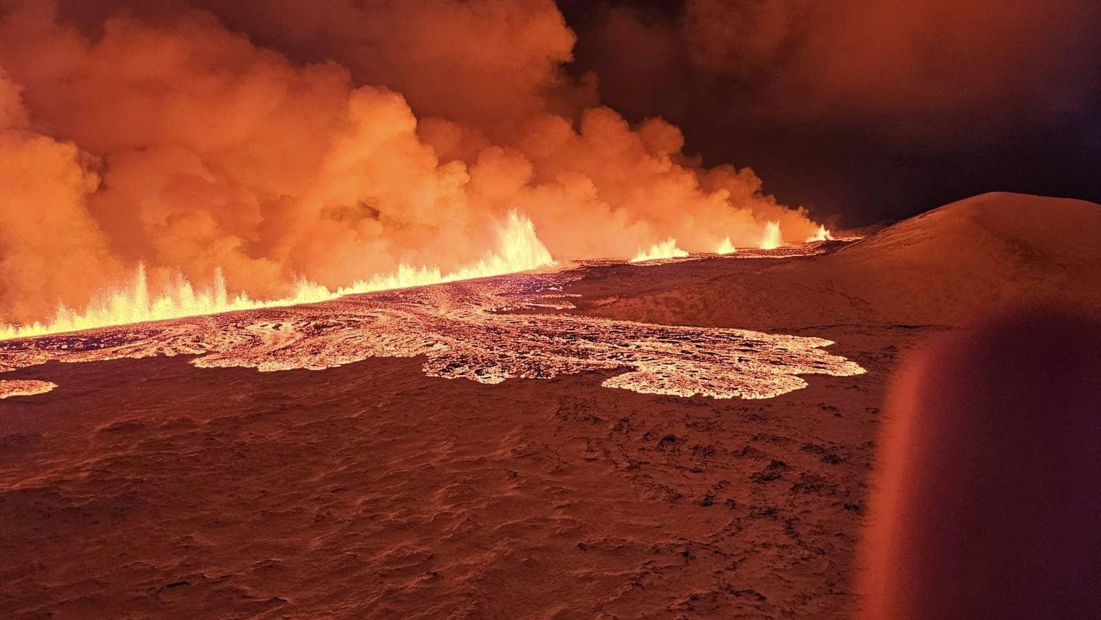
Iceland , Reykjanes Peninsula :
Increased probability of a new eruption .Updated 29 December at 15:15 UTC
The ground continues to inflate at Svartsengi. At the GPS station Svartsengi (SENG), the land has now reached a similar height as measured just before the eruption on 18 December. The rate of uplift since 18 December has remained constant, which is different from the situation before the last eruption, where uplift slowed in the days before the eruption. However, it is difficult to assert that the uplift will slow down before the next eruption, though this has been the case in eruptions on the Reykjanes Peninsula in recent years, and it was also noted during the Krafla Fires. Uncertainty remains about how much magma pressure needs to build up before magma starts moving towards the surface.
The current uplift is not accompanied by as much seismic activity as before. The reason for this is that significant stress in the area was released during the events on 10 November and 18 December. Therefore, considerably more magma needs to accumulate before seismic activity increases from its current level. Before the last eruption, there were several earthquakes over magnitude 3 and one over magnitude 4. Similar seismic activity can be expected in connection with the next magma intrusion.
As magma accumulation continues under Svartsengi, the likelihood of another magma intrusion and an eruption increases with each passing day. It is most likely that the next eruption will occur in the Sundhnúkur, between Stóra-Skógfell and Hagafell. It is important to note that magma intrusions do not always lead to an eruption, as shown by the activity at Fagradalsfjall and in the Krafla Fires.
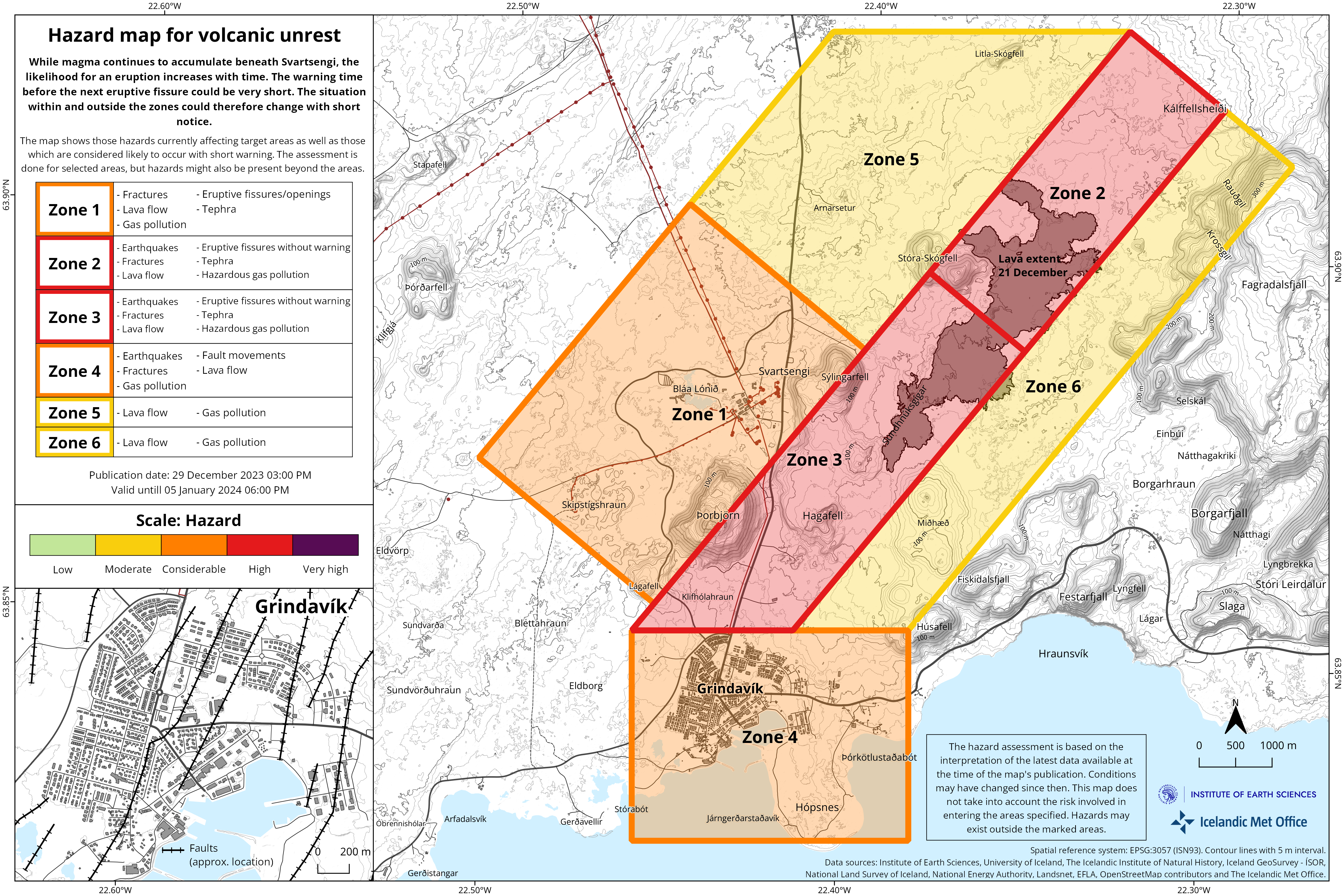
The Icelandic Meteorological Office has issued an updated hazard map, based on the joint interpretation of data at a status meeting held today, 29 December. The overall assessment of hazard levels within the areas remains unchanged from the last update. However, changes have been made to the list of potential hazards within area 4, Grindavík, where risks due to possible lava flow and gas pollution have been added. The changes are due to increased chances of an eruption north of Grindavík. This hazard map will be reviewed on 5 January 2024.
In the meantime, IMO continues to monitor the area and any changes will be communicated directly to civil protection via the usual communication channels.
Source : IMO
Photos : Almannavarnadeild ríkislögreglustjóraI , IMO.
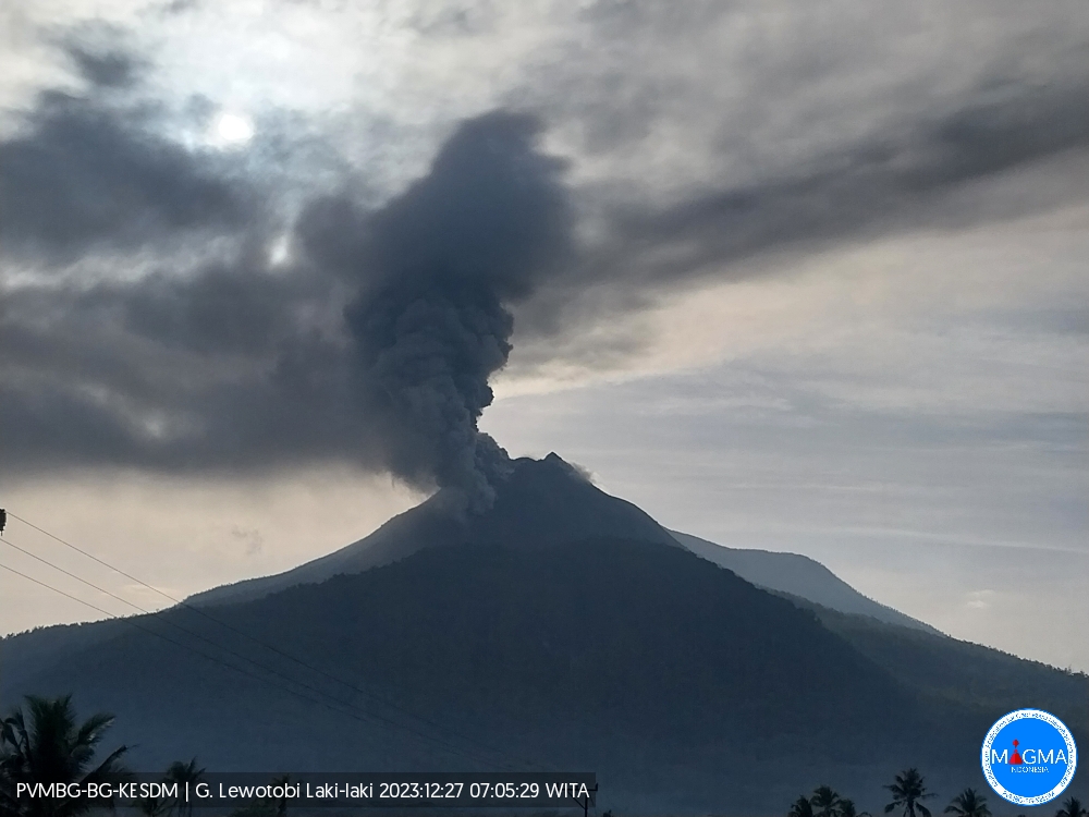
Indonesia , Lewotobi Laki-laki :
Increase in the activity level of G. Lewotobi from level II (WASPADA) to level III (SIAGA).
The results of the assessment of the activity of G. Lewotobi Laki-Laki for the period from December 1, 2023 to January 1, 2024 are presented below as follows:
I. Visual observation
The volcano is clearly visible until it is covered in fog. The smoke observed coming from the crater is white, gray/black of medium to thick intensity approximately 100-800 meters from the summit. After the eruption of December 23, 2023, a fissure was observed northwest of the summit, 160 meters long and emitting thick white smoke 300 meters high. On January 1, 2024, a new eruption center was observed originating from a fracture south-southeast of the summit of Mount Lewotobi Laki. An eruption occurred at 1000-1500 meters altitude above the summit, the ash column from the eruption was white, gray to black.
II. Instrumental observation
Seismicity recorded during the period from December 1 to 31, 2023:
5 explosions/eruptions earthquakes,
44 emissions earthquakes
3 harmonic tremors,
1 non-harmonic tremor,
7 “Tornillo” type earthquakes,
20 shallow volcanic earthquakes
113 deep volcanic earthquakes,
42 times local tectonic earthquakes,
79 times distant tectonic earthquakes
Continuous tremor with a maximum amplitude of 2 to 5.1 mm (dominant value 3.7 mm). On January 1, 2024 at 00:03 WITA, there was an increase in continuous tremors with an amplitude reaching 7 mm.
III. Potential danger
The potential danger that could arise is an explosive eruption at a distance of more than 3 km emitting eruption materials. Stronger eruptive activity may cause landslides in the fracture zone and warm clouds with a sliding distance of up to 4 km to the Northwest, North and Southeast.
IV. Assessment and recommendations
Visual observations during the period from December 1, 2023 to December 31, 2023 showed that the volcanic activity of Mount Lewotobi Laki experienced a significant increase, including observing columns of smoke with a height ranging from 300 to 800 meters from the central crater and from the fractures northwest of the summit. With the appearance of new cracks in the northeast direction on January 1, 2024, this shows that the smoke exhalation activity of the crater is expanding so that the threat level will increase.
Earthquake observations show a significant increase in deep volcanic earthquakes and shallow volcanic earthquakes over the past month. The recording of continuous tremors caused a significant increase in the RSAM value. The emergence of these earthquakes indicates an increase in pressure/stress on the volcanic body which is linked to the supply of magma at depth and at shallow depths.
The increase in seismicity since December 12, 2023 has also been followed by the emergence of Tornillo-type earthquakes linked to fluid movements in the hydrothermal system. This condition was then followed by eruptions and emissions indicating shallow or already surface volcanic activity.
Based on the results of visual and instrumental monitoring, it shows that there has been an increase in visual and seismic activity on Mt. Lewotobi Laki, and being aware of the appearance of warm clouds towards the crater fracture, the activity level of Mount Lewotobi Laki increased from Level II (WASPADA) to Level III (SIAGA), effective from January 1, 2024 at 04:00 WITA:
– Communities around Mount Lewotobi and visitors/tourists do not carry out any activities within a radius of 3 km around the center of the eruption of Mount Lewotobi and within a radius of 4 km in the North-North-West and South directions -Southeast of the eruption center of Mount Lewotobi.
Source et photo : PVMBG.
Kamchatka , Klyuchevskoy :
VOLCANO OBSERVATORY NOTICE FOR AVIATION (VONA)
Issued: December 31 , 2023
Volcano: Klyuchevskoy (CAVW #300260)
Current aviation colour code: ORANGE
Previous aviation colour code: orange
Source: KVERT
Notice Number: 2023-168
Volcano Location: N 56 deg 3 min E 160 deg 38 min
Area: Kamchatka, Russia
Summit Elevation: 4750 m (15580 ft)
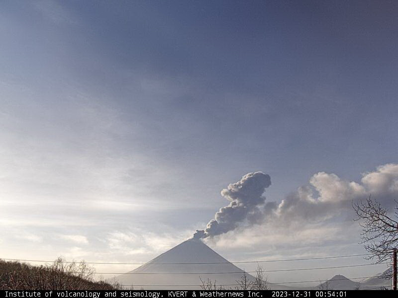
The explosive eruption of Vulcanian type of the Klyuchevskoy volcano on 31 December, 2023. The volcano congratulates Kamchatka on the upcoming New Year!
Volcanic Activity Summary:
The eruptive activity of Klyuchevskoy volcano continues. Satellite and video data by KVERT showed a gas-steam plume containing some amount of ash is extending for 110 km to the west-northwest of the volcano.
The activity of the volcano continues. A danger of ash rising up to 7 km (23,000 ft) a.s.l. remains. Ongoing activity could affect low-flying aircraft.
Volcanic cloud height:
5500-6000 m (18040-19680 ft) AMSL Time and method of ash plume/cloud height determination: 20231231/2335Z – Video data
Other volcanic cloud information:
Distance of ash plume/cloud of the volcano: 110 km (68 mi)
Direction of drift of ash plume/cloud of the volcano: WNW / azimuth 300 deg
Time and method of ash plume/cloud determination: 20231231/2250Z – Himawari-9 14m15
Source : Kvert
Photo : IVS FEB RAS, KVERT
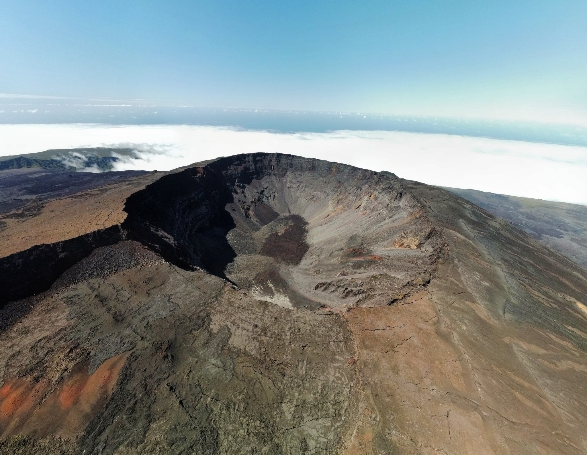
La Réunion , Piton de la Fournaise :
Seismicity
In December 2023, the OVPF-IPGP recorded in total at the Piton de la Fournaise massif:
• 12 superficial volcano-tectonic earthquakes (0 to 2.5 km above sea level) under the summit craters;
• 5 deep earthquakes (below sea level);
• 0 long-period earthquakes;
• 203 landslides.
The month of December 2023 will have been marked by low seismicity under the Piton de la Fournaise with an average of 0.4 superficial volcano-tectonic earthquakes per day. Five deep earthquakes were also recorded.
Only one superficial volcano-tectonic earthquake could be located – under the Dolomieu crater – and four deep earthquakes – under the eastern flank. The others – of lower magnitudes – could not be located.
Numerous (203) landslides in the Dolomieu Crater, at the Cassé de la Rivière de l’Est and at the level of recent lava flows were also recorded.
Deformation
In November 2023, a resumption of peak inflation was recorded. This ended at the end of November. Since then, a weak summit deflation has been recorded.
Balance sheet
A magmatic migration from the depths towards the superficial reservoir, located at 2-2.5 km depth, was highlighted in November 2023 by surface deformations and CO2 fluxes in the soil. But since December 2023, magma replenishment and pressurization of the surface reservoir have ceased.
At the same time, seismicity remained low with an average of 0.4 volcano-tectonic earthquakes per day recorded under the summit craters in December 2023.
Note that since 2016, the replenishment of the superficial magmatic reservoir under the Piton de la Fournaise has taken place in pulses, thus such phases of calm in deformations and seismicity have already been observed on several occasions between 2016 and 2023 over periods ranging from approximately 15 to 80 days.
Source : OVPF
Photo : Tunnels de lave Réunion : Rando-Volcan