December 09 , 2023.
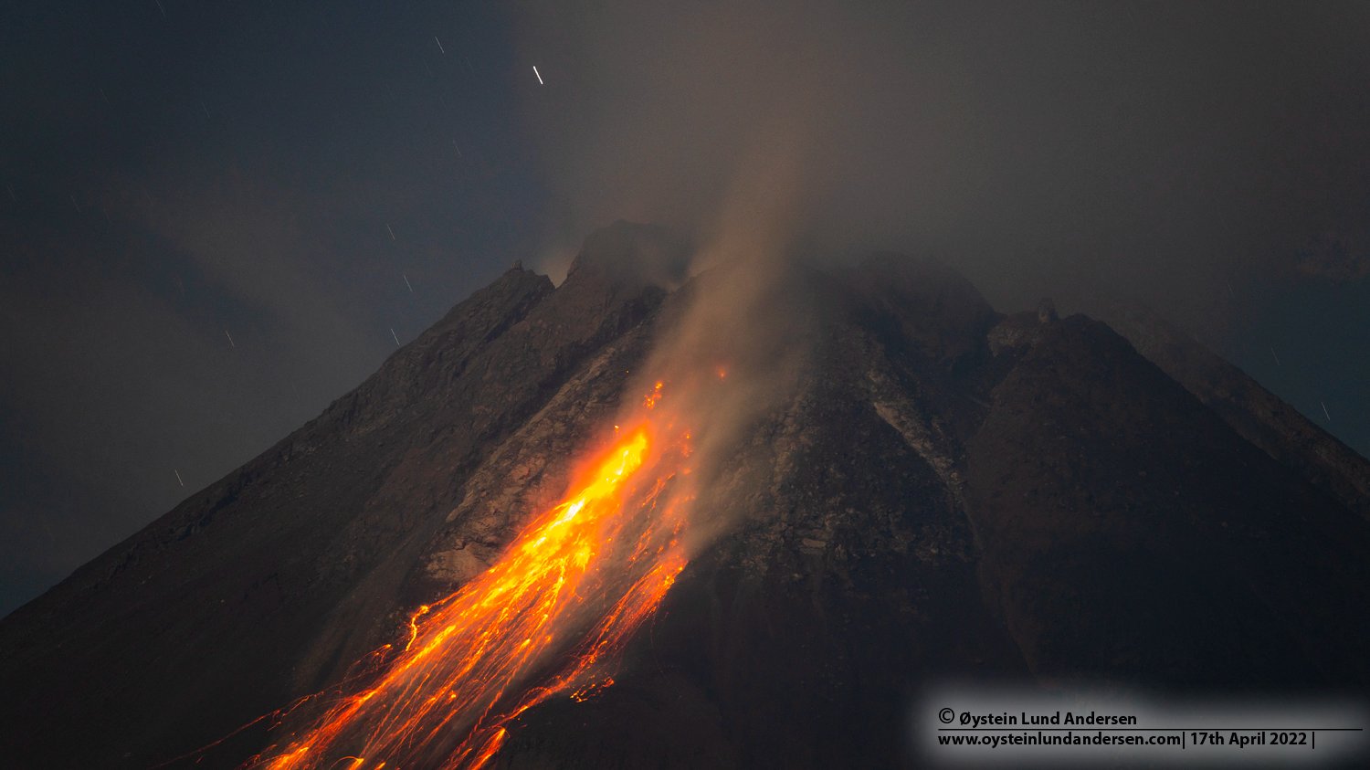
Indonesia , Merapi :
Mount Merapi activity report from December 1 to 7, 2023, Published on December 9, 2023.
OBSERVATION RESULTS
Visual
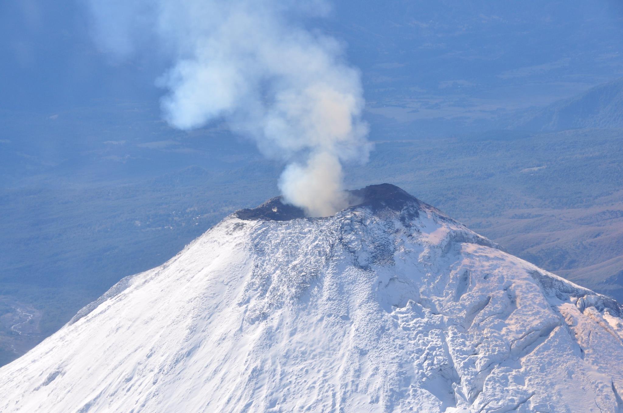
The weather around Mount Merapi is generally clear in the morning and evening, while it is foggy from noon to evening. White smoke, thin to thick, low to moderate pressure and 75 m high was observed from the observation post of Mount Merapi Babadan on December 2, 2023 at 05:30 WIB.
This week, there were 6 warm cloud avalanches, namely 2 times in the South (upstream of Kali Boyong) with a maximum sliding distance of 1,300 m and 4 times in the South-West (upstream of Kali Krasak and Bebeng) with a maximum sliding distance of 3,000 m. Light ash rain was reported to have occurred in Sawangan District, Magelang and Selo District, Boyolali. Lava avalanches were observed 192 times in the South and South-West, including 23 times upstream of the Boyong River over a maximum distance of 1,500 m and 169 times upstream of the Bebeng River over a maximum distance of 1,700 m. mr. The sound of avalanches was heard 4 times from Kaliurang and Babadan posts with low to moderate intensity.
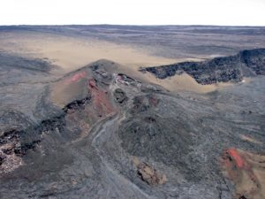
The morphology of the Southwest dome was observed to change due to dome growth activities as well as the presence of hot clouds and lava avalanches. The highest hot spot reached 286.7°C, lower than the previous measurement temperature. The morphology of the median dome is relatively constant. The highest hot spot reached 209.2°C, higher than the previous measurement temperature. Based on the analysis of aerial photos dated November 16, 2023, the volume of the southwest dome was measured at 3,348,600 m3 and that of the central dome at 2,358,000 m3.
Seismicity
This week, Mount Merapi seismicity recorded:
6 Warm Cloud Avalanche (APG) earthquakes,
38 superficial volcanic earthquakes (VTB),
888 multi-phase (MP) earthquakes,
1 low frequency earthquake (LF),
1,045 avalanche earthquakes (RF),
17 tectonic earthquakes (TT).
The intensity of earthquakes this week is still high, notably the VTB and MP earthquakes which indicate an increase in magmatic activity at a depth less than 1.5 km from the summit.
Deformation
The deformation of Mount Merapi monitored by EDM this week shows that the distance from the ridge is retreating, with an average of 0.1 cm/day.
Rain and lahars
This week there was rain at Mount Merapi lookout post with a rain intensity of 122 mm/hour for 25 minutes at Kaliurang lookout post on December 5, 2023. No additional flow or lahar was reported in the rivers that have their source on Mount Merapi.
Conclusion
Based on the results of visual and instrumental observations, it was concluded that:
Volcanic activity at Mount Merapi is still quite high in the form of effusive eruptive activity. The activity status is at the “SIAGA” level.
Source : BPPTKG
Photo : Oystein Lund Andersen ( archive).
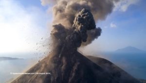
Chile , Villarica :
Seismology
The seismological activity of the period was characterized by the recording of:
A continuous tremor signal associated with the fluid dynamics inside the volcano, which presented during the period an energy variation, evaluated with the RSAM parameter, between 0.9 and 1.8 µm/s, values considered above their base level.
200 seismic events of type VT, associated with the fracturing of rocks (Volcano-Tectonics). The most energetic earthquake had a Local Magnitude (ML) value equal to 3.0, located 4.1 km east-southeast of the volcanic edifice, at a depth of 4.7 km relative to to the crater.
17,300 LP-type seismic events, associated with fluid dynamics inside the volcanic system (Long Period). The size of the largest earthquake evaluated from the Reduced Displacement (RD) parameter was equal to 54 cm2.
1772 TR type seismic events, associated with the dynamics maintained over time of fluids inside the volcanic system (Tremor). The size of the largest earthquake evaluated from the Reduced Displacement (RD) parameter was equal to 31 cm2.
Fluid geochemistry
The sulfur dioxide (SO2) emissions data obtained by the differential optical absorption spectroscopy (DOAS) equipment, corresponding to the Los Nevados and Tralco stations, installed respectively at 10 km in an East-North-East direction and 6 km East-South-East of the active crater, presented an average value of 2406 ± 815 t/d, which is higher than the usual values for this volcanic system. The maximum daily value was 5211 t/d on November 30.
4 anomalies were reported by satellites in sulfur dioxide (SO2) emissions into the atmosphere in the area near the volcano, on November 21, 23, 24 and 25, according to data published by the Tropospheric Monitoring Instrument (TROPOMI), Mounts, and Pluem Traj Daily Data.
Thermal anomalies by satellites
During the period, 21 thermal alerts were recorded in the area associated with the volcano, with a maximum volcanic radiative power (VRP) of 151 MW on November 30, a value considered moderate according to data processed by the Mid-Infrared Observation of volcanic activity. (MIROVA). Thanks to the analysis of Sentinel 2-L2A satellite images, 3 radiance anomalies were detected in the area associated with the crater, on November 21, 24, 26 and 29. The NHI tools platform detected a maximum area of anomalous radiation in the crater area of 45,900 m2 on November 26.
During the period evaluated, significant changes in internal and surface dynamics were observed. On the one hand, discreet seismic activity remained very productive.
events linked to fluid dynamics and the recording of higher energy acoustic signals. This corresponds temporally to the increase in the SO2 flux and thermal emissivity measured by satellite, which reached a maximum value of 151 MW considered high according to the values reached historically, recording of nocturnal incandescence and appearance of Strombolian explosions, which triggered the dispersion of pyroclastic fragments on the surface that reached horizontal distances from the crater center of up to 250 m. Towards the northeast sector of the crater edge, he observed a surface change linked to an undifferentiated deposit having reached a distance of 540 m. The above suggests the continuation of the action of the lava lake located near the surface, dynamic and with abrupt changes in its activity level. Based on the above, it is determined that the observed processes are expected at the current technical alert level, maintaining it at YELLOW and maintaining its possible impact radius at 500 m from the center of the crater.
YELLOW TECHNICAL ALERT: Changes in the behavior of volcanic activity
Observation: a potential proximal volcanic danger zone is considered within a radius of 500 m from the active crater
Source et photo : Sernageomin
Hawaii , Kilauea :
Friday, December 8, 2023, 8:31 AM HST (Friday, December 8, 2023, 18:31 UTC)
19°25’16 » N 155°17’13 » W,
Summit Elevation 4091 ft (1247 m)
Current Volcano Alert Level: ADVISORY
Current Aviation Color Code: YELLOW
Activity Summary:
Kīlauea volcano is not erupting. Over the past day there has been moderate seismicity in the summit region, upper East Rift Zone, and Southwest Rift Zone. Unrest may continue to wax and wane with fluctuating input of magma to the area, and eruptive activity could occur in the near future with little or no warning. No unusual activity has been noted along the middle and lower sections of Kīlauea’s East Rift Zone.

Summit Observations:
Seismicity in Kīlauea’s summit region began climbing late on December 6, and over the past day there have been brief periods of heightened earthquake rates. Activity has not reached the levels that immediately preceded recent summit eruptions, but slightly elevated seismicity continues at this time. Most of the earthquakes are focused in two clusters just south and southeast of Kaluapele, Kīlauea’s summit caldera.
The Uēkahuna summit tiltmeter—located northwest of the caldera—tracked a small deflation-inflation (DI) event yesterday morning, and another beginning yesterday evening that is still proceeding though its inflationary phase this morning. The Sand Hill tiltmeter—located southwest of the caldera—has tracked similar trends. Overall, the summit of Kīlauea remains at a high level of inflation; relative tilt is above the level reached prior to the most recent eruption in September 2023, and it is higher than at any time since the 2018 eruption.
Sulfur dioxide (SO2) gas emission rates remain low. Field measurements indicated an SO2 emission rate of approximately 70 tonnes per day on December 5, which was similar to measurements in October and November.
Source : HVO
Photo : USGS.
La Réunion , Piton de la Fournaise :
press release from the Paris Institute of Globe Physics, Piton de la Fournaise Volcanological Observatory. December 8, 2023 – 10:20 p.m. – 6:20 p.m. UTC
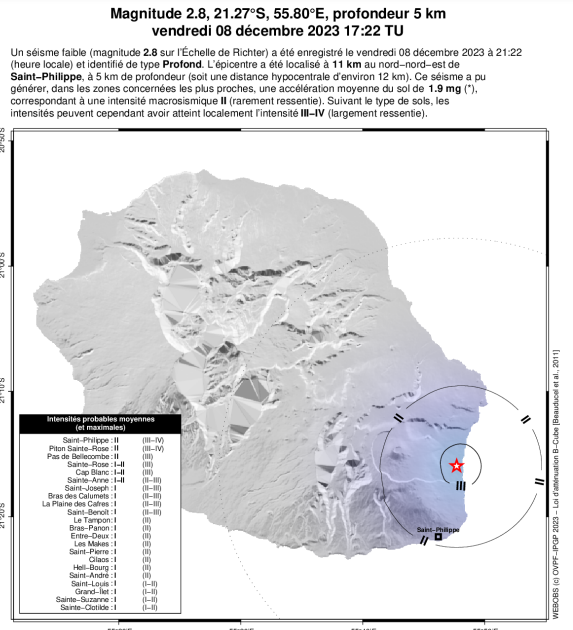
Earthquake felt
On Friday, December 8, 2023 at 9:22 p.m. (local time – 5:22 p.m. UT), an earthquake was felt by residents of the island, mainly in the southeast sector of the island.
This earthquake was recorded by the seismometers of the Piton de la Fournaise Volcanological Observatory. The first analyzes of this earthquake made it possible to locate it 5 km below sea level under the eastern flank of the volcano, 11 km north-northeast of Saint-Philippe. Its magnitude was measured at 2.8 on the Richter scale.
OVPF staff are working to refine the location calculations for this event. Also information regarding location and intensity could evolve marginally.
Call for testimonials on felt earthquakes: the real intensities (effects of an earthquake in a given location) can only be correctly determined by collecting testimonies. If you felt this earthquake, even slightly, you are invited to report it to the BCSF (French Central Seismological Bureau) on the site http://www.franceseisme.fr/
Source et photo : direction de l’OVPF-IPGP
Ecuador , Sangay :
DAILY REPORT ON THE STATE OF THE SANGAY VOLCANO, Friday December 8, 2023.
Information Geophysical Institute – EPN.
Surface activity level: High, Surface trend: No changes
Internal activity level: High, Internal trend: No changes
Seismicity: From December 7, 2023, 11:00 a.m. to December 8, 2023, 11:00 a.m.:
The number of seismic events recorded at the reference station over the past 24 hours is shown below. The level of seismic activity of the volcano remains high.
Explosion Event (EXP): 185
Precipitation/Lahars:
Rains were recorded in the volcano area without generating mudslides or debris. In the event of heavy rains, these could remobilize the accumulated materials, generating mud and debris flows which would descend down the sides of the volcano and flow into adjacent rivers.
Emissions/ash column:
Due to weather conditions, it was not possible to observe surface activity using the surveillance camera system. The VAAC agency in Washington detected two emissions of ash, the heights of which reached 866 meters above the level of the crater, in a West-North-West direction.
Gas:
The Mounts satellite system reported 74.8 tons of SO2 measured on 07/12/2023 at 1:17 p.m. TL.
Other monitoring parameters:
The MIROVA-VIIRS satellite system recorded 1 low thermal alert (3 MW), the MIROVA-MODIS satellite system recorded 2 low thermal alerts (1 MW) and the WORLD VIEW satellite system recorded 4 thermal alerts in 24 hours.
Observation:
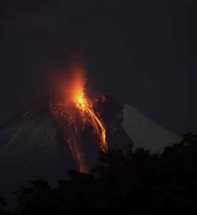
The volcano remained cloudy most of the time. During the night and early in the morning, incandescence was observed several times at the crater. At the time of closing this report, the volcano is completely cloudy.
Alert level: yellow
Source : IGEPN.
Photo : Diego Cardenas.