December 04 , 2023.
Indonesia , Marapi :
Press release on the eruption of Mount Marapi, WEST SUMATRA, December 3, 2023.
Marapi Volcano is administratively located in Agam Regency and Tanah Datar Regency, West Sumatra Province. Mount Marapi is monitored visually and instrumentally from the Volcano Observation Post (PGA).
Mount Marapi’s volcanic activity in early 2023 was dominated by explosive eruptions that took place from January 7, 2023 to February 20, 2023 with an eruptive column height between 75 and 1,000 meters from the summit. Subsequently, the eruption stopped and seismic activity was dominated by local tectonic earthquakes and distant tectonic earthquakes. The current activity level has been at Level II (WASPADA) since August 3, 2011.
The latest developments on Mount Marapi activities until December 3, 2023 at 6:00 p.m. WIB are as follows:
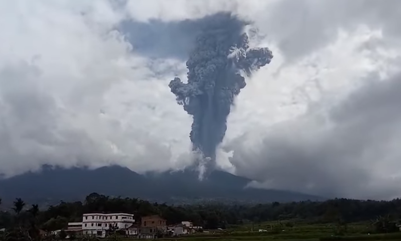
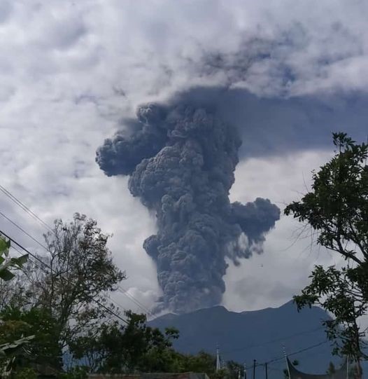
An explosive eruption occurred on December 3, 2023 at 2:54 p.m. WIB with the height of the ash column observed at approximately 3,000 meters above the summit (5,891 m above sea level). The ash column was observed to be gray in color with thick intensity, oriented towards the East. This eruption was recorded on a seismograph with a maximum amplitude of 30 mm and a duration of 4 minutes 41 seconds.
The eruption on December 3, 2023 at 2:54 p.m. WIB was accompanied by a northward pyroclastic flow with a sliding distance of 3 km. At present, subsequent eruptions are still ongoing based on PVMBG instrumental observations.
The eruption on December 3, 2023 at 2:54 p.m. WIB was not preceded by a significant increase in volcanic earthquakes. Deep volcanic earthquakes (VA) were recorded only 3 times between November 16, 2023 and December 2, 2023. The deformation equipment (tilt meter) at the peak station showed a horizontal trace on the radial axis and slight inflation on the tangential axis. This shows that the eruption process takes place quickly and that the center of pressure is only at shallow depth (around the summit).
Based on the results of observations and analysis of visual and instrumental data until December 3 at 18:00 WIB, the activity level of Mount Marapi is still at level II (WASPADA). In connection with the level of activity of Mount Marapi at Level II (WASPADA), it is recommended:
People around Mount Marapi and visitors/tourists are not allowed to carry out activities/approach Marapi within a 3 km radius of the crater/summit.
It is hoped that residents around Mount Marapi will remain calm and not be provoked by rumors about the eruption. The community should always follow the instructions of the regional government.
VOLCANO OBSERVATORY NOTICE FOR AVIATION – VONA
Issued : Décember 03 , 2023
Volcano : Marapi (261140)
Current Aviation Colour Code : RED
Previous Aviation Colour Code : orange
Source : Marapi Volcano Observatory
Notice Number : 2023MAR031
Volcano Location : S 0 deg 22 min 52 sec E 100 deg 28 min 23 sec
Summit Elevation : 9251 FT (2891 M)
Volcanic Activity Summary :
Eruption with volcanic ash cloud at 07h54 UTC (14h54 local).
Volcanic Cloud Height :
Best estimate of ash-cloud top is around 18851 FT (5891 M) above sea level or 9600 FT (3000 M) above summit. May be higher than what can be observed clearly. Source of height data: ground observer.
Other Volcanic Cloud Information :
Ash cloud moving from north, west to northwest. Volcanic ash is observed to be gray to dark. The intensity of volcanic ash is observed to be thick.
Remarks :
Eruption recorded on seismogram with maximum amplitude 30 mm and maximum duration 281 second. Tremor recorded on seismogram with maximum amplitude 30 mm.
Source : PVMBG , Magma Indonésie .
Photos : Buya Khalifah, Edward Ardy .
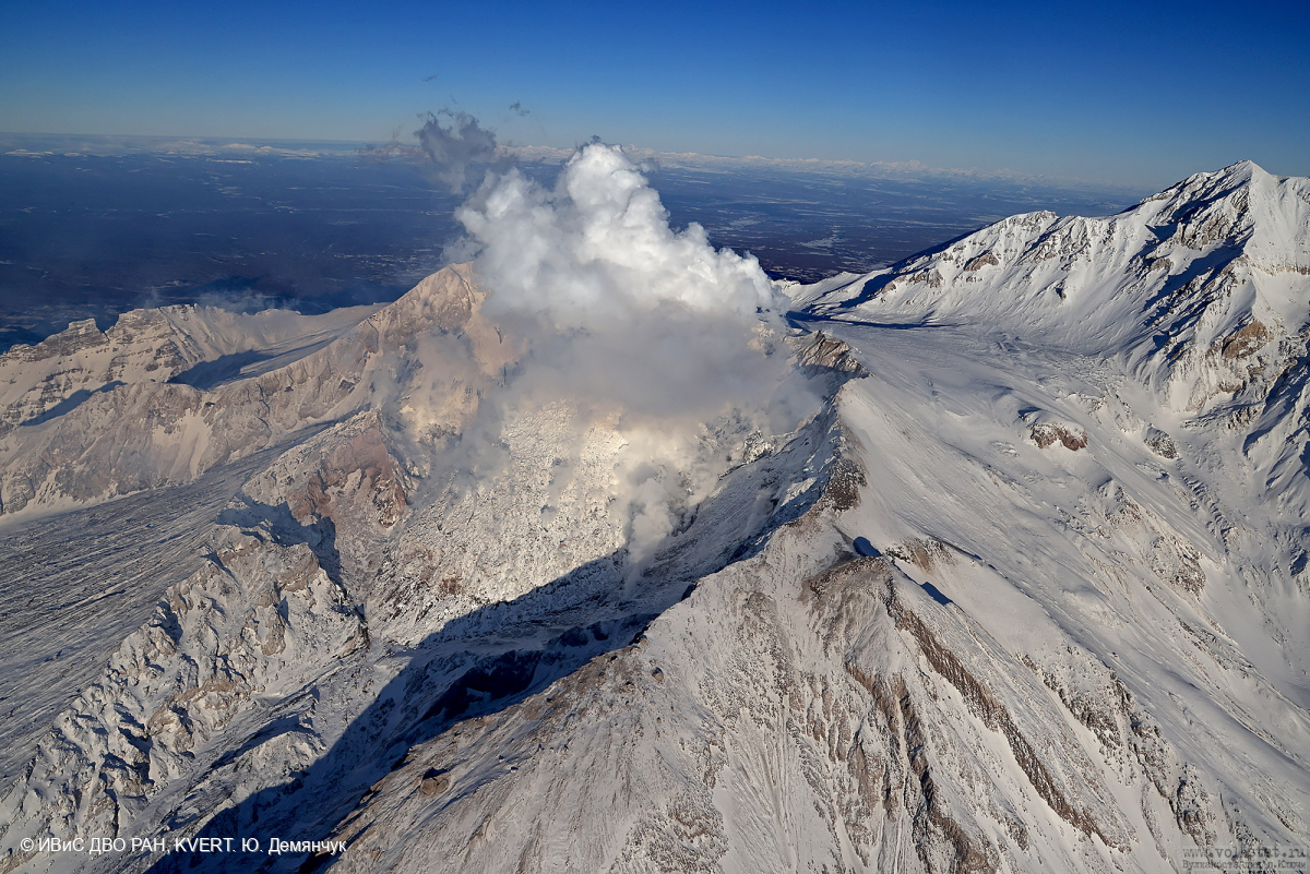
Kamchatka , Sheveluch :
VOLCANO OBSERVATORY NOTICE FOR AVIATION (VONA)
Issued: Décember 04 , 2023.
Volcano: Sheveluch (CAVW #300270)
Current aviation colour code: ORANGE
Previous aviation colour code: orange
Source: KVERT
Notice Number: 2023-162
Volcano Location: N 56 deg 38 min E 161 deg 18 min
Area: Kamchatka, Russia
Summit Elevation: 3283 m (10768.24 ft), the dome elevation ~2500 m (8200 ft)
Volcanic Activity Summary:
Video and satellite data by KVERT shows a strong wind lifts ash from the southern slopes of Sheveluch volcano, and a plume of resuspended ash is extending for 230 km to the south-east of the volcano.
An extrusive-effusive eruption of the volcano continues. Ongoing activity could affect low-flying aircraft.
Volcanic cloud height:
2000-2500 m (6560-8200 ft) AMSL Time and method of ash plume/cloud height determination: 20231204/0030Z – Himawari-9 14m15
Other volcanic cloud information:
Distance of ash plume/cloud of the volcano: 230 km (143 mi)
Direction of drift of ash plume/cloud of the volcano: SE / azimuth 126 deg
Time and method of ash plume/cloud determination: 20231204/0030Z – Himawari-9 14m15
Source : Kvert
Photo : Yu. Demyanchuk. IVS FEB RAS, KVERT
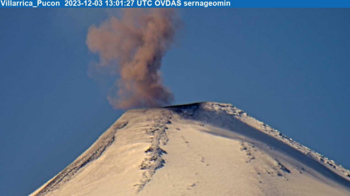
Chile , Villarica :
Special Report on Volcanic Activity (REAV), La Araucanía and Los Ríos regions, Villarrica volcano, December 3, 2023, 11:05 a.m. local time (mainland Chile)
The National Geology and Mining Service of Chile (Sernageomin) announces the following PRELIMINARY information, obtained through the monitoring equipment of the National Volcanic Monitoring Network (RNVV), processed and analyzed at the Southern Andean Volcano Observatory (Ovdas):
On Sunday, December 3, 2023, at 10:00 a.m. local time (1:00 p.m. UTC), monitoring stations installed near the Villarrica volcano recorded an earthquake associated with fluid dynamics inside the volcanic system (long-period type), accompanied by a pulse of particulate materials.
The characteristics of the earthquake after its analysis are as follows:
ORIGINAL TIME: 10:00 a.m. local time (1:00 p.m. UTC)
REDUCED TRAVEL: 25.9 (cm*cm)
The characteristics of the associated surface activity are as follows:
MAXIMUM HEIGHT OF THE COLUMN: 320 meters above the crater
DIRECTION OF SPREAD: Northeast (NE)
Observation :
Due to the characteristics of the seismic signal associated with the LP event, we could deduce that the ashes emitted from the crater originated from a partial landslide at the surface level. There is a probability that other similar events will occur during the day.
This behavior is consistent with the current technical alert level.
The technical volcanic alert is maintained at YELLOW level.
Source et photo : Sernageomin.
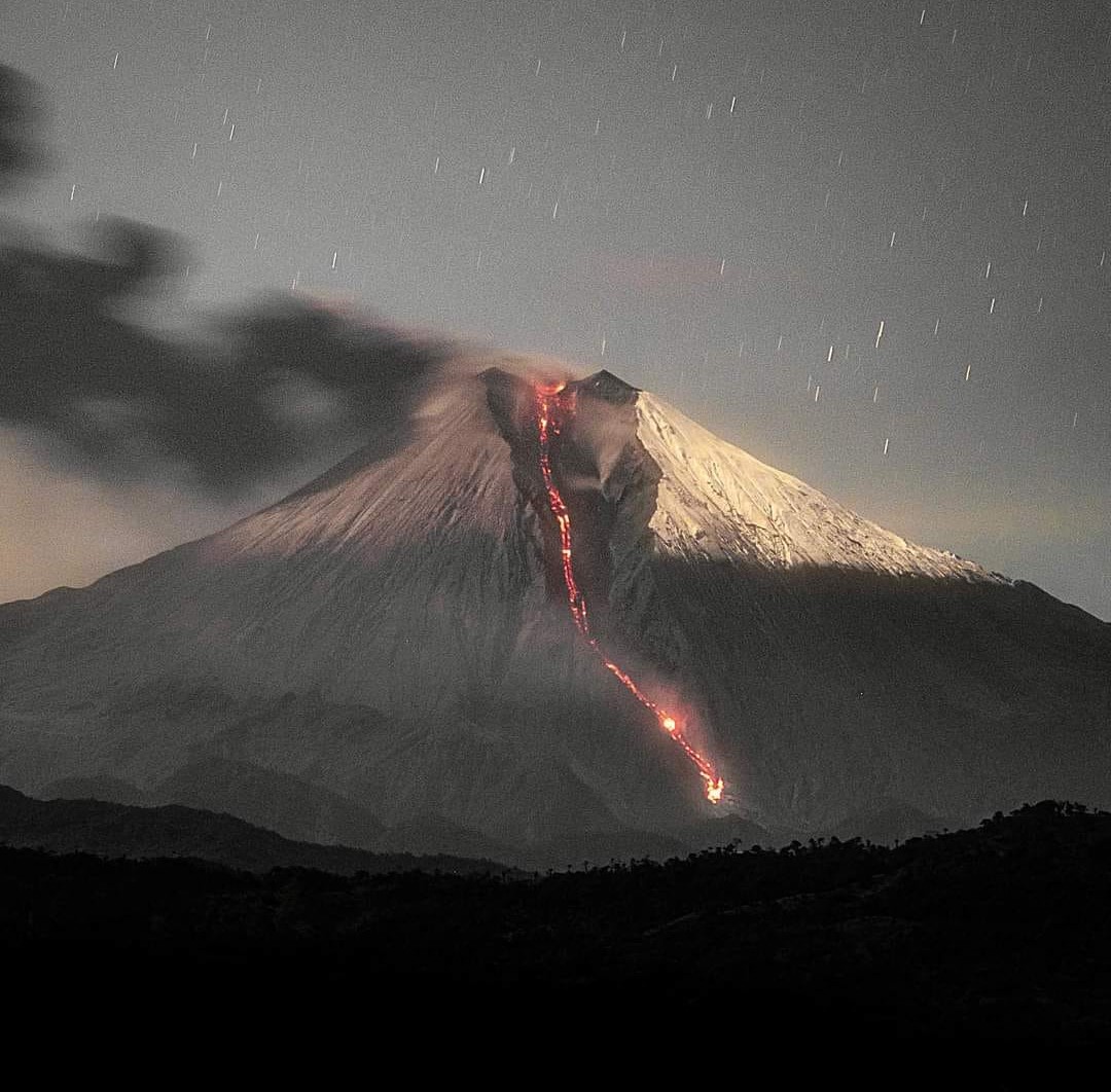
Ecuador , Sangay :
DAILY REPORT ON THE STATE OF THE SANGAY VOLCANO, Sunday December 3, 2023.
Information Geophysical Institute – EPN.
Surface activity level: High, Surface trend: No changes
Internal activity level: High, Internal trend: No changes
Seismicity: From December 2, 2023, 11:00 a.m. to December 3, 2023, 11:00 a.m.:
The number of seismic events recorded at the reference station over the past 24 hours is shown below. The level of seismic activity of the volcano remains high.
Explosion Event (EXP): 321
Precipitation/Lahars:
No rain was recorded in the volcano area. *In the event of heavy rains, these could remobilize the accumulated materials, generating mud and debris flows which would descend the sides of the volcano and flow into adjacent rivers*
Emissions/ash column:
During the last 24 hours, thanks to the GOES-16 satellite, two emissions of gas and ash were recorded with heights of 1000 and 800 meters above the level of the crater in the southwest direction. In addition, the Washington VAAC published two reports on gas and ash emissions with heights of 866 and 1171 meters above the crater level in the southwest directions.
Gas:
The MOUNTS system recorded 61.3 tons of sulfur dioxide (SO2), measured on 02/12/2023 at 1:12 p.m. TL.
Other monitoring parameters:
The FIRMS satellite system recorded 8 thermal anomalies, the MIROVAMODIS satellite system recorded 2 thermal anomalies and the MIROVA-VIIRS satellite system recorded 1 weak thermal anomaly; in the last 24 hours.
Observation:
During last night, several episodes of expulsion of incandescent material were observed, which descended through the Southeast ravine up to 1,800 meters below the level of the crater. From morning until the close of this report, the volcano remained completely cloudy.
Alert level: yellow
Source : IGEPN.
Photo : Eqphos_fotografía
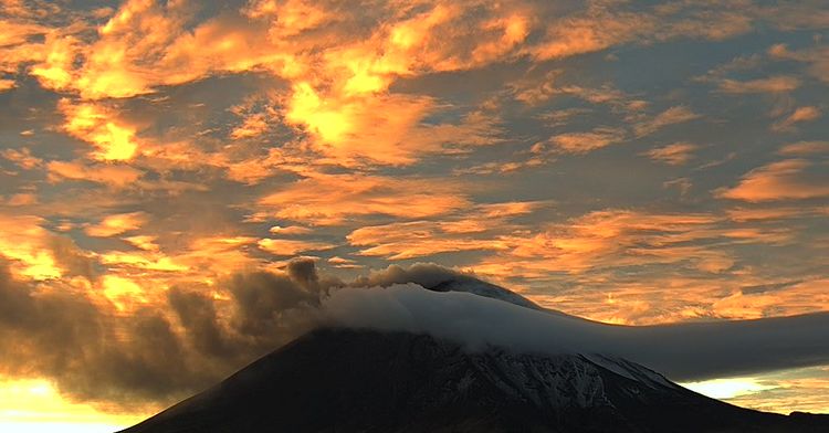
Mexico , Popocatepetl :
The volcanic warning fire of the Popocatépetl volcano is in YELLOW PHASE 2. Cenapred recommends NOT APPROACHING the volcano and especially the crater, due to the danger posed by falling incandescent fragments.
National Disaster Reduction Center | December 3, 2023
14 exhalations and 1,145 minutes of tremors were detected. Monitoring of the Popocatépetl volcano is carried out continuously 24 hours a day. Any change in activity will be reported as soon as possible.
Activity from the last 24 hours
14 exhalations were detected, accompanied by water vapor, volcanic gases and ash. Additionally, 1,145 minutes of tremors were identified.
The Popocatépetl volcanic warning fire is in yellow phase 2.
Recommendations
Cenapred insists: do not attempt to climb the volcano, as explosions occur that throw incandescent fragments, as has been seen recently. Respect the exclusion radius of 12 kilometers around the crater, being in this area is not safe. During heavy rain, stay away from ravine bottoms, due to the danger of mud and debris flows.
Source : Cenapred