December 03 , 2023.
Alaska , Great Sitkin :
52°4’35 » N 176°6’39 » W,
Summit Elevation 5709 ft (1740 m)
Current Volcano Alert Level: WATCH
Current Aviation Color Code: ORANGE
Slow eruption of lava is continuing at Great Sitkin Volcano. Seismicity has been low during the past week. The volcano was obscured by clouds in satellite data for most of the week, but weakly elevated surface temperatures were observed in clearer views on November 25. Satellite radar observations through November 30 showed continued growth of the summit lava flow, including minor expansion of the lava low into the intracrater glacier to the east, motion of the flow surface away from the vent, and local uplift of the lava directly above the vent that is causing radial cracks to form on the lava flow surface.
The current lava flow at Great Sitkin Volcano began erupting in July 2021. No explosive events have occurred since a single event in May 2021.
The volcano is monitored by local seismic, geodetic, and infrasound sensors, web cameras, regional infrasound and lightning networks, and satellite data.
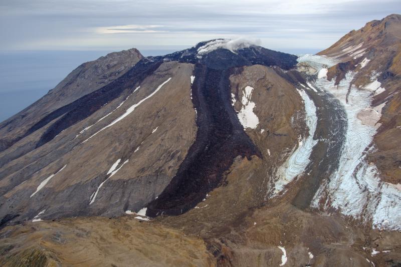
Great Sitkin Volcano on September 3, 2023, during helicopter approach for sampling efforts by AVO geologists. Image is looking northeast
Great Sitkin Volcano is a basaltic andesite volcano that occupies most of the northern half of Great Sitkin Island, a member of the Andreanof Islands group in the central Aleutian Islands. It is located 26 miles (43 km) east of the community of Adak. The volcano is a composite structure consisting of an older dissected volcano and a younger parasitic cone with a ~1 mile (1.5 km)-diameter summit crater. A steep-sided lava dome, emplaced during the 1974 eruption, occupies the center of the crater. That eruption produced at least one ash cloud that likely exceeded an altitude of 25,000 ft (7.6 km) above sea level. A poorly documented eruption occurred in 1945, also producing a lava dome that was partially destroyed in the 1974 eruption. Within the past 280 years a large explosive eruption produced pyroclastic flows that partially filled the Glacier Creek valley on the southwest flank.
Source : AVO
Photo : Loewen, Matt / Alaska Volcano Observatory / U.S. Geological Survey
Indonesia , Anak Krakatau :
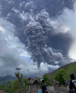
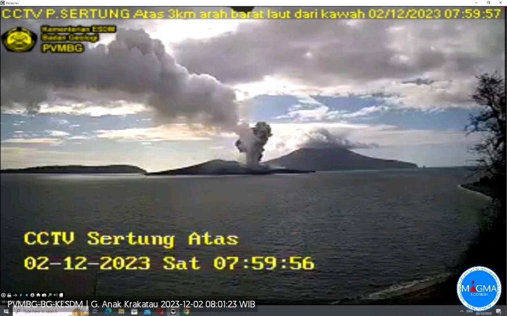
An eruption of Mount Anak Krakatau occurred on Saturday, December 2, 2023 at 10:37 p.m. WIB. The height of the eruptive column was observed to be ± 800 m above the peak (± 957 m above sea level). The ash column was observed to be gray to black in color with thick intensity, oriented towards the North-West. The eruption was recorded on a seismograph with a maximum amplitude of 50 mm and a duration of 34 seconds
VOLCANO OBSERVATORY NOTICE FOR AVIATION – VONA
Issued : Décember 02 , 2023
Volcano : Anak Krakatau (262000)
Current Aviation Colour Code : ORANGE
Previous Aviation Colour Code : orange
Source : Anak Krakatau Volcano Observatory
Notice Number : 2023KRA094
Volcano Location : S 06 deg 06 min 07 sec E 105 deg 25 min 23 sec
Area : Lampung, Indonesia
Summit Elevation : 502 FT (157 M)
Volcanic Activity Summary :
Eruption with volcanic ash cloud at 15h37 UTC (22h37 local).
Volcanic Cloud Height :
Best estimate of ash-cloud top is around 3062 FT (957 M) above sea level or 2560 FT (800 M) above summit. May be higher than what can be observed clearly. Source of height data: ground observer.
Other Volcanic Cloud Information :
Ash cloud moving to northwest. Volcanic ash is observed to be gray to dark. The intensity of volcanic ash is observed to be thick.
Remarks :
Eruption recorded on seismogram with maximum amplitude 50 mm and maximum duration 34 second.
Source et photo : Magma Indonésie.
Philippines , Mayon :
MAYON VOLCANO BULLETIN 03 December 2023 8:00 AM
In the past 24-hour period, the Mayon Volcano Network recorded two (2) volcanic earthquakes. The lava flows have maintained their advances to approximately 3.4 kilometers in Bonga (southeastern), 2.8 kilometers in Mi-isi (south), and 1.1 kilometers in Basud (eastern) Gullies. Rockfalls and PDCs generated by the collapse of the summit dome deposited debris still within four (4) kilometers of the crater. Volcanic sulfur dioxide (SO2) emission averaged 1,279 tonnes/day on 02 December 2023.

Short-term observations from electronic tilt and GPS monitoring indicate inflation of the northwestern upper slope since late July 2023. Longer-term ground deformation parameters from EDM, precise leveling, continuous GPS, and electronic tilt monitoring indicate that Mayon is still generally inflated relative to baseline levels.
Alert Level 3 is maintained over Mayon Volcano, which means that it is currently in a relatively high level of unrest, and hazardous eruption within weeks or even days could still be possible.
Source : Phivolcs
Photo : Auteur inconnu ( archives).
Colombia , Cumbal :
Weekly activity bulletin from the Cumbal Volcanic Complex
Regarding the monitoring of the activity of the CUMBAL VOLCANIC COMPLEX (CVC), the MINISTRY OF MINES AND ENERGY, through the COLOMBIAN GEOLOGICAL SERVICE (SGC), reports that:
During the period between November 21 and 27, 2023 and compared to the previous week, volcanic seismicity increased both in its occurrence and in its energy released, with a predominance of seismicity associated with the fracturing of rocks at inside the volcanic complex. The earthquakes were located in a scattered manner in the zone of influence of the CVC, at distances less than 11 km, at depths less than 8 km compared to the reference height (4,700 m above sea level). the sea) and with a maximum magnitude of 1.4.
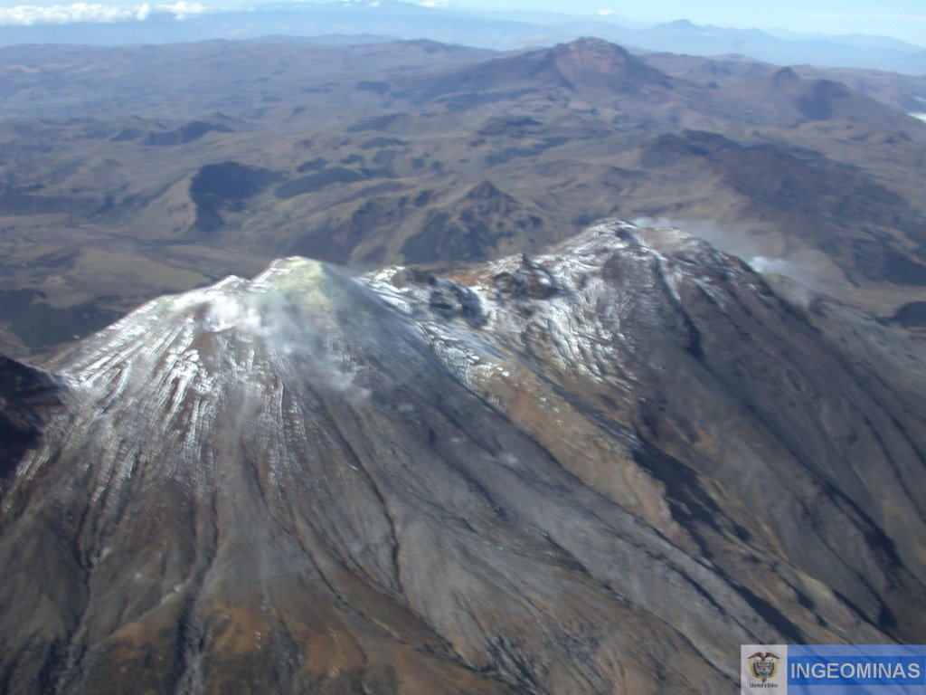
Gas emissions were recorded from the El Verde fumarole zone, northeast of the CVC, and from the Los Rastrojos, Boca Vieja and Las Bandas fumarole zones, southwest of the CVC, with white columns whose height and dispersion varied depending on the wind regime. Other volcanic monitoring parameters showed stability.
Volcanic activity remains on YELLOW ALERT, Status: Active volcano with changes in the behavior of the base level of monitored parameters and other manifestations
Source : SGC
Photo : Ingeominas
Hawaii , Kilauea :
Saturday, December 2, 2023, 9:24 AM HST (Saturday, December 2, 2023, 19:24 UTC)
19°25’16 » N 155°17’13 » W,
Summit Elevation 4091 ft (1247 m)
Current Volcano Alert Level: ADVISORY
Current Aviation Color Code: YELLOW
Activity Summary:
Kīlauea volcano is not erupting. Seismicity increased dramatically in the south caldera region just before midnight and returned to lower levels just after 5 a.m. this morning. While the volcano tectonic earthquakes have subsided pulses of small, long period earthquakes that cannot be accurately located are occurring beneath Halemaʻumaʻu indicating that unrest continues. Seismicity remains low to the southwest of the caldera and in the upper East Rift Zone. Unrest may continue to wax and wane with changes to the input of magma into the area and eruptive activity could occur in the near future with little or no warning. No unusual activity has been noted along the middle and lower sections of Kīlauea’s East Rift Zone.
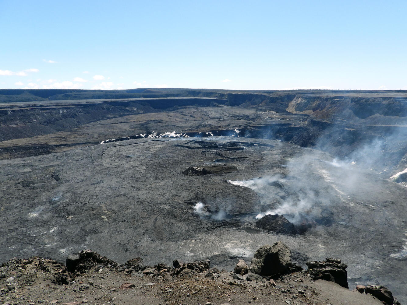
Summit Observations:
Summit seismicity was elevated over the past 24 hours, with a strong seismic swarm in the south caldera that produced about 90 earthquakes from just before midnight to just after 5 a.m. HST. Minor small earthquakes also occured in the upper East Rift Zone during this period. Activity this morning has subsided, but bursts of long period activity that cannot be located accurately continue beneath Halemʻaumaʻu. These earthquakes are indicative of continued magmatic unrest.
The seismic swarm in the south caldera was accompanied by strong uplift on the Sand Hill tiltmeter located in that region. Tilt flattened at the Sand Hill tiltmeter just before 5 a.m. and earthquakes began diminshing soon after that. The Uēkahuna summit tiltmeter, located northwest of the caldera, showed mixed signals over the past 24 hours, with the NE component increasing 0.5 microradians and the NW component decreasing 1 microradian. Overall, the summit of Kīlauea remains at a high level of inflation, above the level reached prior to the most recent eruption in September 2023, and the highest level since the 2018 eruption.
Sulfur dioxide (SO2) emission rates remain low. Field observations found SO2 gas emmision of 100 tonnes per day on November 17. This is the same as an observation in October 2023.
Source : HVO
Photo : USGS / K. Mulliken. ( archive)