November 29 , 2023.
Italy / Sicily , Etna :
WEEKLY BULLETIN, from November 20, 2023 to November 26, 2023. (issue date November 28, 2023)
SUMMARY STATEMENT OF ACTIVITY
In light of the monitoring data, it appears:
1) VOLCANOLOGICAL OBSERVATIONS: Strombolian-type eruptive activity at the South-East crater and degassing at the Bocca Nuova crater.
2) SISMOLOGY: Absence of seismic fracturing activity with Ml>=2.0. Average amplitude of medium-high level volcanic tremor.
3) INFRASOUND: High rate of occurrence of infrasound events.
4) GROUND DEFORMATIONS: Over the last week, the ground deformation monitoring networks have not recorded significant variations.
5) GEOCHEMISTRY: Mid-level So2 flux
CO2 fluxes from the ground are at medium-low values.
The partial pressure of CO2 dissolved in groundwater presents values included in seasonal variability.
The helium isotope ratio in peripheral sites is on average (R/Ra=0.52)
6) SATELLITE OBSERVATIONS: Thermal activity observed by satellite was generally low level with rare and isolated anomalies of moderate to high level.
VOLCANOLOGICAL OBSERVATIONS
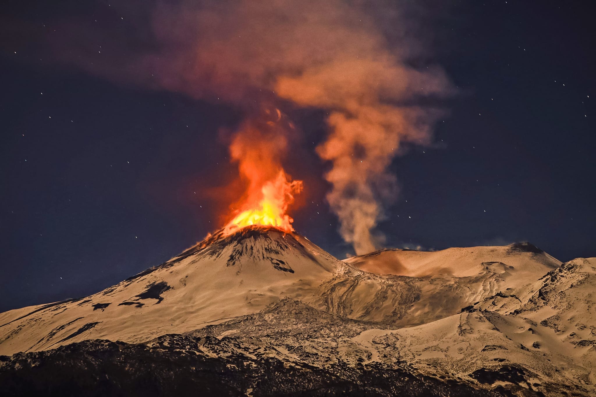
During the observation period, monitoring of Etna was carried out using INGV surveillance cameras; Due to unfavorable weather conditions, observation of activity was not continuous but limited to fractions of hours during each day. However, it was possible to observe that during this period the volcano was characterized by a continuous eruptive state at the level of the South-East crater coupled with an overall stability of the other craters compared to what had been observed in the months previous ones.
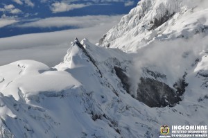
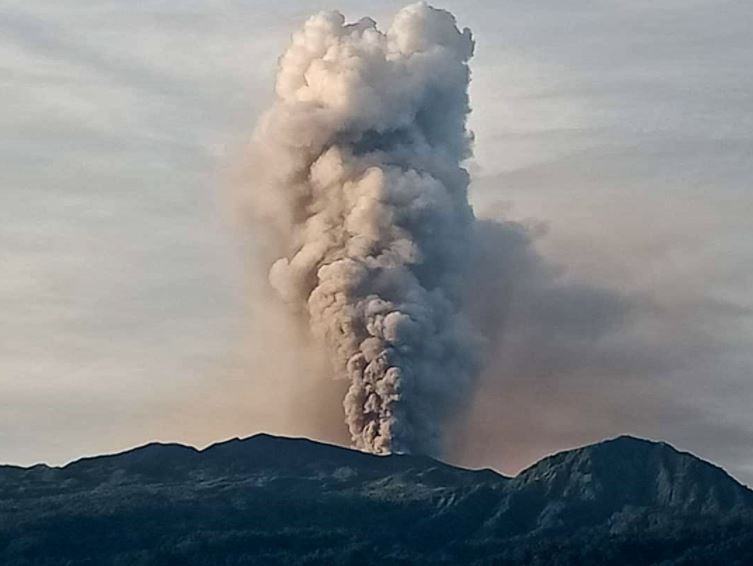
In detail, the South-East crater showed eruptive activity of the Strombolian type throughout the period characterized by a variable regime both in intensity and in frequency of appearance of transients of explosive activity. This variability modulated on the scale of hours over the course of the days, with particular vigor between November 25 and 26 with a higher intensity of the explosions. This variability modulated on the scale of hours over the days, with particular vigor between November 25 and 26 with a higher intensity of explosions compared to the other days. However, eruptive activity has always remained confined to the crater area with fallout of explosion products near the cone and production of modest ash emissions with rapid dispersion near the summit area in the direction of the prevailing winds. .
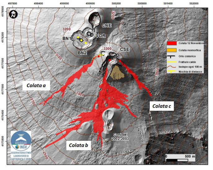
On November 24 from ~5:10 p.m. to ~2:50 a.m. the following day (times in GMT), explosive activity was also associated with an isolated, modest episode of effusive activity originating from lava overflow from the crater. The dynamic progression of the lava flow was very slow, taking place on the southern side of the crater cone along the ravine from where one of the three flows emitted during the eruptive activity of November 12 progressed, to then stop at the base of the cone itself (casting b see fig 3.1).
It should be noted that the effusive episode occurred during a phase of variability in Strombolian activity with a transition from low to high explosive intensity. During the week, other episodic thermal anomaly phenomena with morphology associated with lava flows were observed in the same southern area of the Southeast crater cone (e.g., November 26 ~ 5:55 p.m. GMT) . However, the analysis of the data showed that in these cases, the dynamics and characteristics of these thermal anomalies differed from those observable in the case of lava flows. Furthermore, these episodes occurred and were often concomitant with transients of high explosive intensity and therefore associated with rapid and continuous deposition of the products of eruptive activity outside the crater cone on the southern slope (rheomorphic deposits,
Regarding the eruptive state of the other craters, as in previous months, the second source of contribution to the volcanic plume of Etna is produced by Bocca Nuova with pulsed degassing and emission of hot gases visible at night in the form of glows. Regarding the Northeast Crater, it remains in a state of weak and isolated intra-crater fumarolic degassing, while Voragine remains in the absence of activity.
Source : INGV.
Photos : INGV , Giovanni Passalacqua
Italy , Stromboli :
WEEKLY BULLETIN, from November 20, 2023 to November 26, 2023. (issue date November 28, 2023)
SUMMARY STATEMENT OF ACTIVITY
In light of the monitoring data, it appears:
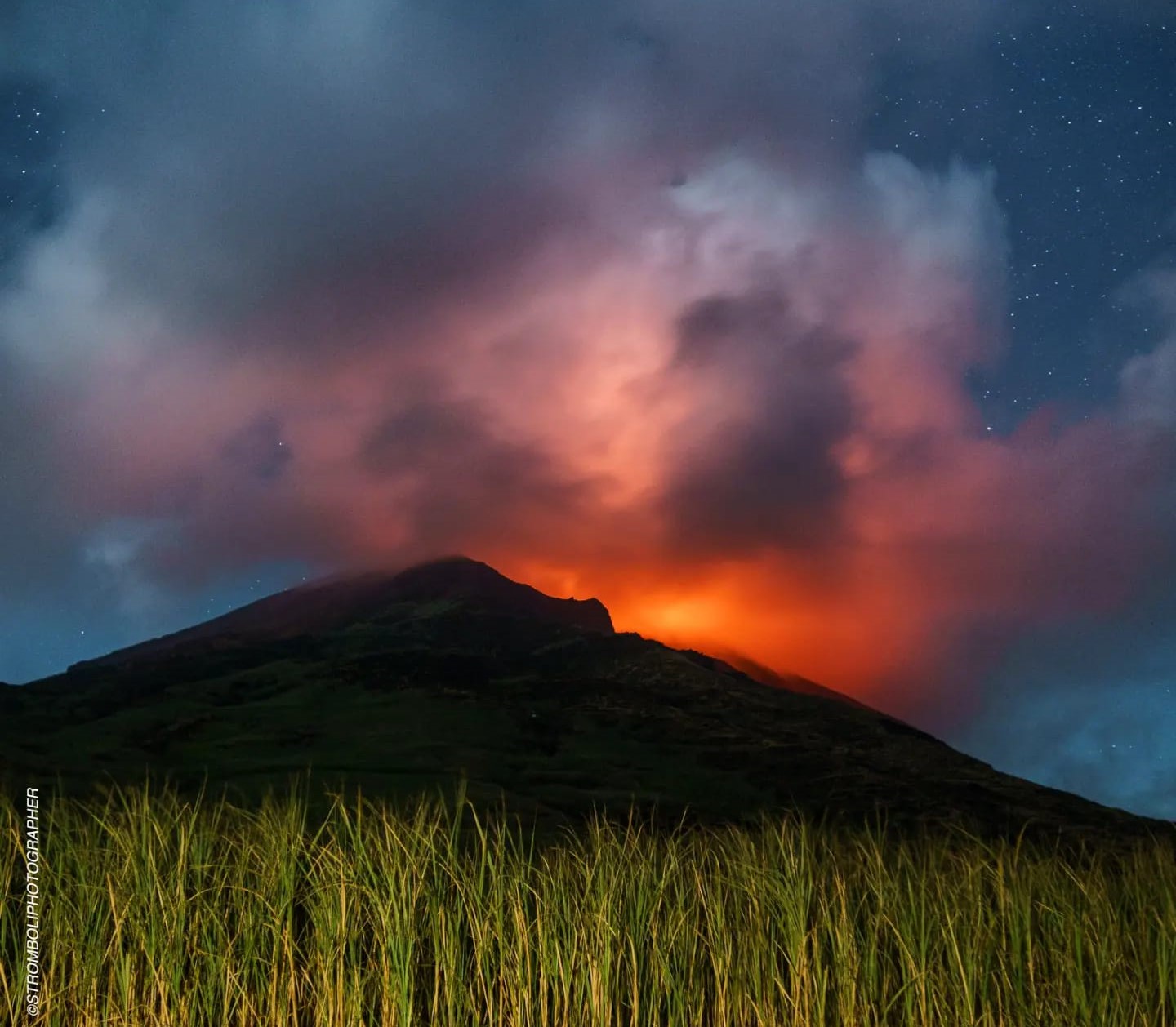
1) VOLCANOLOGICAL OBSERVATIONS: Normal Strombolian activity was observed during this period. The total hourly frequency of explosions fluctuated between medium and high values (10-16 events/h). The intensity of the explosions was low in the North crater area and variable from low to high in the South-Central area.
2) SISMOLOGY: The monitored seismological parameters do not show significant variations.
3) GROUND DEFORMATIONS: The island’s ground deformation monitoring networks did not show significant variations over the period examined
4) GEOCHEMISTRY: SO2 flux at medium level
CO2 flow in the Pizzo area: no update available.
There is no update on the C/S ratio in the plume.
The isotopic ratio of dissolved helium in the thermal aquifer is at medium-high values. (last collection on November 15, 2023)
CO2 flow in Scari: the data is at medium-high values around 220 g/m2d (latest data from November 24, 2023)
5) SATELLITE OBSERVATIONS: Thermal activity observed by satellite was generally low level with rare and isolated anomalies of moderate level.
VOLCANOLOGICAL OBSERVATIONS
In the observed period, the eruptive activity of Stromboli was characterized through the analysis of images recorded by the surveillance cameras of the INGV-OE at altitude 190m (SCT-SCV), of Pizzo (SPT) and Point dei Corvi (SPCT). The explosive activity was mainly produced by 2 (two) eruptive vents located in the North zone of the crater and by 2 (two) vents located in the South Central zone.
Observations of explosive activity captured by surveillance cameras.
In the area of the North crater (N), with one vent located in sector N1 and one in sector N2, low intensity explosive activity was observed (explosion height less than 80 m). The products of the eruption consisted mainly of coarse materials (bombs and lapilli). The average frequency of explosions fluctuated between 5 and 7 events/h.
In the Central-South zone (CS) sectors S1 and C did not show significant activity, while in sector S2 two active vents were observed which also showed simultaneous activity of varying intensity from weak to high (explosion height greater than 150 m) with emission of mainly coarse material. The average frequency of explosions varied between 5 and 10 events/h.
Source : INGV.
Photo : Stromboli stati d’animo / Sebastiano Cannavo.
New Zealand , Ruapehu :
Earthquake activity recorded beneath Mt Ruapehu. Te Wai ā-moe (Crater Lake) slowly heating. Volcanic activity remains low, and the Volcanic Alert Level remains at Level 1.
Published: Mon Nov 27 2023 4:00 PM
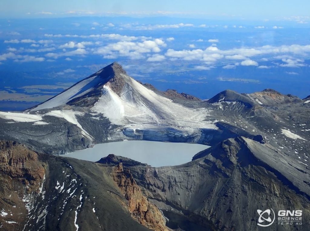
The earthquake monitoring system at Mt Ruapehu has recently recorded a sequence of small earthquakes at 3-6 km depth clustered under the volcano. Te Wai ā-moe (Ruapehu Crater Lake) is slowly heating, currently reaching 19 °C. Other volcanic monitoring indicators remain within normal ranges. Volcanic activity remains low. The Volcanic Alert Level remains at Level 1 and the Aviation Colour Code at Green.
Between 21 and 26 November we located a sequence of 40 small earthquakes ranging in size from M0.3 to M1.8 beneath Mt Ruapehu (Figure 1). Earthquakes were located between 3 and 6 km beneath the volcano, with most in the 4-5 km range. Very similar earthquake activity was observed at the beginning of 2022 (RUA 2022/01).

Since mid-October, the temperature of Te Wai ā-moe (Crater Lake) has been slowly increasing, although it was impacted by recent rainfall. Past history shows that the lake temperature drops temporarily due to short-lived input of snow melt and heavy rainfall into the lake. These short-term variations do not affect the long-term heating or cooling trends. The heat flow into the lake is currently low at around 80 MW, typical of a cooler lake.
An observation flight on 22 November noted the lake colour had changed to a blue green from the more common grey colour seen in the last few months. No upwellings were observed, although sulphur slicks were seen on the lake surface and the lake was overflowing.
The level of volcanic tremor recorded by our seismic equipment has remained weak during 2023, with no response noted after the earthquakes. Since installation, our new scanDOAS gas scanning equipment has measured low-to-moderate levels of SO2 gas output most days.
The recent earthquakes under the volcano may be related to either a faulting process or the injection of new magma at depth under the volcano. The latter would increase the likelihood of an eruption, however, it is unclear from our monitoring data which process is driving the earthquake activity.
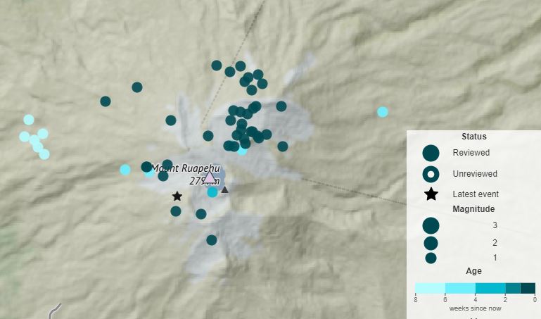
Figure 1: Earthquake locations (circles) beneath Mt Ruapehu. Darker coloured circles show earthquakes during the past week. Lighter coloured circles show older earthquakes.
The change in lake colour is consistent with less gas flow disturbing sediment at the base of the lake. Low to moderate gas flux values and lake temperatures that are low but slowly increasing indicate, however, that the lake vents are at least partially open.
Volcanic tremor, a key indicator of volcanic fluid movement, remains low and most other monitoring indicators are within normal ranges. Overall, this is consistent with a low level of volcanic activity.
As a result, the Volcanic Alert Level remains at Level 1. The Aviation Colour Code remains Green.
Source : Geonet.
Photos : GNS , Geonet
Indonesia , Dukono :
Press release on the increase in the activity of G. DUKONO, NOVEMBER 29, 2023.
Dukono Volcano (G. Dukono) is a volcano located in North Halmahera Regency, North Moluccas Province, at an altitude of 1,087 m above sea level. Geographically, Mount Dukono is located at coordinates 1º 42′ N and 127º 52′ E. This volcano is monitored visually and instrumentally from the Dukono Volcano Observation Post in Mamuya Village, Galela District, North Halmahera Regency, North Moluccas Province .
Mount Dukono’s volcanic activity has remained very active since its eruption in April 2008 with an average of 280 seismic eruptions recorded per day. The particularity of the Mount Dukono eruption is that it produces ash for several days, even several months. The height of the eruption column varies from 50 to 1,000 meters above the crater, the center of activity.
The latest developments in G. Dukono’s activities until November 25, 2023 are as follows:
There was a visually significant increase in eruptive activity, namely an increase in the height of the eruptive column to over 2,000 meters above the summit. On November 18, 2023, the eruption column reached 3,000 meters. On November 25, 2023, the eruption column would have reached 2,600 meters above the peak.
In seismic activity, the number of earthquakes decreased, but the height of the eruptive column became higher. On November 24, 2023, 16 seismic eruptions were recorded, compared to 133 seismic eruptions previously recorded on November 14.
With the increase in the height of the eruption, the current potential danger is the ejection of materials more than 2 km from the center of the eruption and volcanic ash which, depending on the direction and speed of the wind, can reach more remote areas.
Based on visual and instrumental observation data and potential eruption risks as of November 25, 2023 at 3:00 p.m. WIT, the activity level of Mount Dukono is still at Level II (WASPADA) with the following recommendations:
People around Mount Dukono and visitors/tourists are not allowed to climb and approach the Malupang Warirang Crater within a 3 km radius.
During heavy ash rain, people should wear masks covering the nose and mouth to avoid inhaling eruption ash, which can cause respiratory problems.
Source : PVMBG.
Photo : PGA
Colombia , Purace / Chaîne volcanique Los Coconucos :
Weekly bulletin of the activity of the Puracé volcano – Los Coconucos volcanic chain
From the monitoring of the activity of the VOLCANIC CHAIN PURACE VOLCANO – LOS COCONUCOS, the MINISTRY OF MINES AND ENERGY through the COLOMBIAN GEOLOGICAL SERVICE (SGC) reports:
During the week of November 21-27, 2023, there was a decrease in the frequency of seismic events and their energy levels. However, the variations remain higher than the average of the last two months. Likewise, localized deformations continued to be recorded between the Puracé and Curiquinga volcanoes. Regarding the measurement of gases, normal values were recorded in the flow of sulfur dioxide (SO2), while the concentration values of carbon dioxide (CO2) continue to be high, compared to what was recorded so far this year. .
The images obtained using the installed cameras show an increase in degassing from the volcanic system, both inside the crater and in the external lateral fumarole (northwest flank of the volcanic edifice). The analyzed satellite information does not show significant temperature changes in the lateral zone of the fumaroles or inside the crater.
The other parameters measured and used for the diagnosis of volcanic activity showed no notable changes during the period evaluated.
The alert status for volcanic activity remains at: YELLOW ALERT: ACTIVE VOLCANO WITH CHANGES IN THE BEHAVIOR OF THE BASE LEVEL OF MONITORED PARAMETERS AND OTHER MANIFESTATIONS.
Source et photo : SGC