November 22 , 2023.
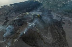
Papua New Guinea , Ulawun :
Eruption of Papua New Guinea volcano subsides, though thick ash is billowing 3 miles into the sky
The eruption of Papua New Guinea’s tallest volcano is subsiding, but thick ash still billowed into the sky and coated roofs and palm trees nearby
The eruption of Papua New Guinea’s tallest volcano subsided Tuesday.
One of the South Pacific nation’s most active volcanoes, Mount Ulawun erupted on Monday afternoon, spewing ash as high as 15 kilometers (50,000 feet).
The alert level for the volcano on the northeastern island of New Britain was downgraded by Papua New Guinea’s Geohazards Management Division to Stage 3, which means a moderate-to-strong eruption. It had been at Stage 4 on Monday, indicating a very strong eruption.
But the volcano, which stands 2,334 meters (7,657 feet) above sea level, remained active and the eruption could continue indefinitely, the division said.
The Volcanic Ash Advisory Center in Darwin, Australia, reported volcanic smoke rising as high as 15,000 meters (50,000 feet) on Monday.
The Papua New Guinea division reported the ash plume rising at least 5,000 meters (16,000 feet) on Tuesday before becoming lost in atmospheric cloud.
The small volcanic particles in ash plumes can be carried long distances by wind and can threaten aviation. A thick plume extended tens of kilometers (miles) to the northwest of Mount Ulawun on Tuesday.
The Civil Aviation Safety Authority of Papua New Guinea did not immediately respond to an email asking if air travel was being affected. The FlightAware tracking website showed normal activity Tuesday at the nearest large airports, in the national capital Port Moresby and in Honiara, the Solomon Islands capital.
The nearest large town is Bialla, which is established among palm oil plantations on Ulawun’s slopes 47 kilometers (29 miles) to the southwest, the division said.
The division said heavy coatings of black ash were causing leaves to droop in palm oil plantations near the volcano and were accumulating on roofs.
The eruption had prompted Japan to assess the risk of a possible tsunami Monday, but none occurred and Papua New Guinea’s division said the threat was “nil.”
Ulawun has repeatedly erupted since 1700s, and its last major eruption in 2019 led to more than 5,000 people being evacuated.
The division said there were no known casualties from Ulawun’s history of eruptions.But major impacts in terms of population displacement, infrastructure damage and disruption to services were common.
Source : ABC news.
Photo : Enoch Lapa
Italy , Stromboli :
WEEKLY NEWSLETTER. from November 13, 2023 to November 19, 2023. (issue date November 21, 2023)
SUMMARY STATEMENT OF ACTIVITY
In light of the monitoring data, it appears:
1) VOLCANOLOGICAL OBSERVATIONS: Normal Strombolian activity was observed during this period. The total hourly frequency fluctuated between average values (10-13 events/h) with the sole exception of November 12 when the frequency reached 20 events/h (high values). The intensity of the explosions was low in the North crater area and variable from low to high in the South-Central area.
2) SISMOLOGY: The monitored seismological parameters do not show significant variations.
3) GROUND DEFORMATIONS: The networks monitoring ground deformations on the island showed small variations over the period considered.
4) GEOCHEMISTRY: SO2 flux at medium level
CO2 flow in the Pizzo area: no update available.
There is no update on the C/S ratio in the plume.
CO2 flow in Scari: A decreasing trend was observed last week.
5) SATELLITE OBSERVATIONS: Thermal activity observed by satellite was generally low level with rare and isolated anomalies of moderate level.
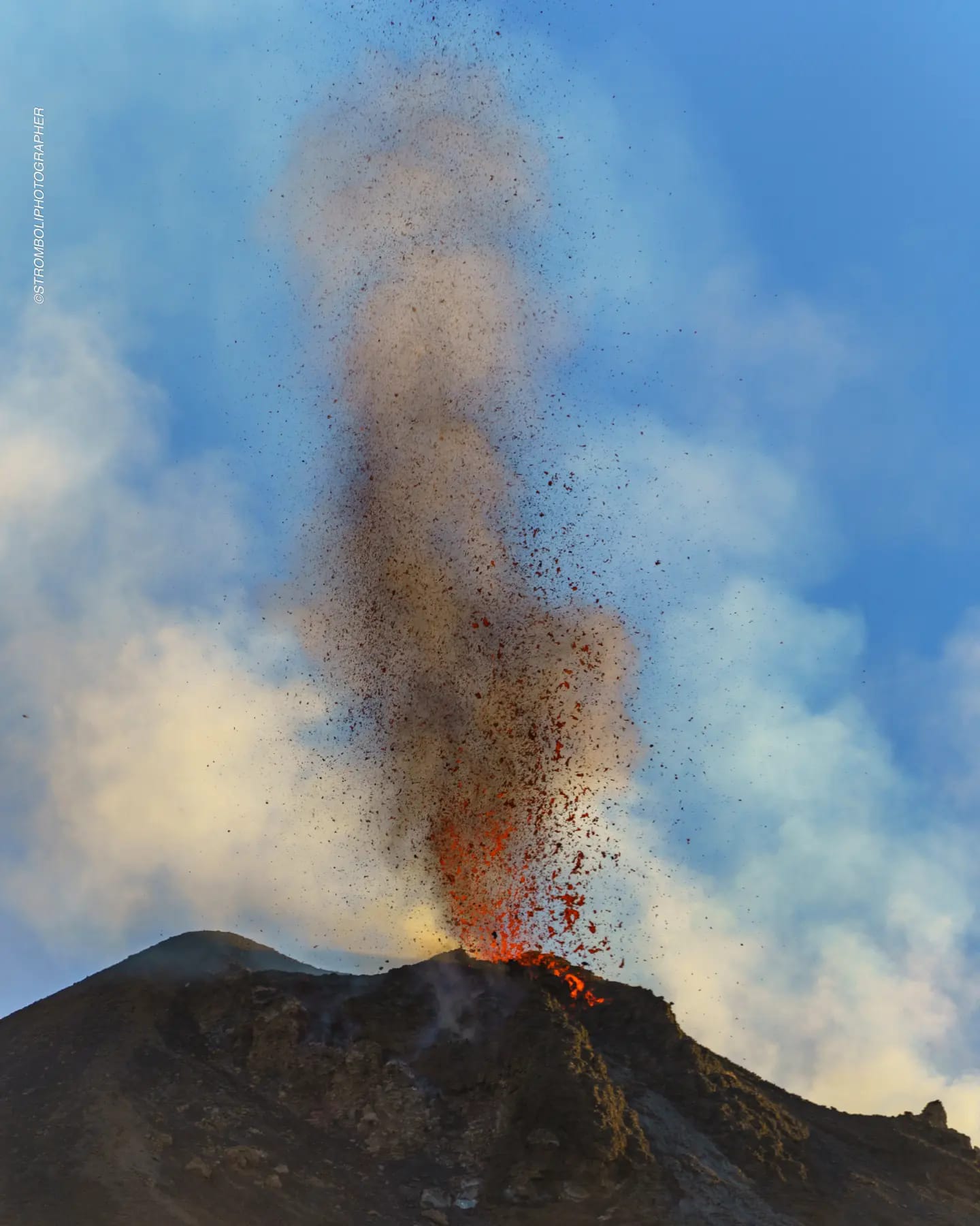
VOLCANOLOGICAL OBSERVATIONS
During the observed period, the eruptive activity of Stromboli was characterized through the analysis of images recorded by the surveillance cameras of the INGV-OE at altitude 190m (SCT-SCV), of Pizzo (SPT) and Point dei Corvi (SPCT). The explosive activity was mainly produced by 3 (three) eruptive vents located in the northern area of the crater and by 2 (two) vents located in the south central area.
Due to unfavorable weather conditions which limited the visibility of the crater terrace, it was not possible to characterize the eruptive activity of November 14 and 17.
Observations of explosive activity captured by surveillance cameras
In the area of the North crater (N), with two vents located in sector N1 and one in sector N2, low intensity explosive activity (less than 80 m in height) was observed. The products emitted in the eruption were mainly coarse materials (bombs and lapilli). The average frequency of explosions fluctuated between 5 and 7 events/h.
In the South-Central (CS) zone, sectors S1 and C did not show significant activity while sector S2 with two active vents, sometimes simultaneously, showed activity of varying intensity from low to high (more 150 m high) with emission of mainly coarse materials. The average frequency of explosions was almost constant with 6-7 events/h with the sole exception of November 12 with 13 events/h.
Source : INGV
Photo : Stromboli stati d’animo / Sebastiano Cannavo.
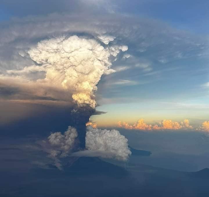
Iceland , Reykjanes Peninsula :
Updated 21. November at 15:30 UTC
Since midnight today,165 earthquakes have been recorded related to the volcanic unrest, all below M2.0. This is considerably fewer than in the last few days when 1,500-1,800 earthquakes were recorded per day. It can be expected that the intense weather passing over the country has an impact on the sensitivity of the seismic monitoring system to detect the smallest earthquakes, making it difficult to assess whether the seismic activity is decreasing overall.
The deformation associated with the dike intrusion that formed on November 10 continues, but the uplift continues near Svartsengi. The speed of the uplift in Svartsengi has remained almost the same in the last 24 hours.
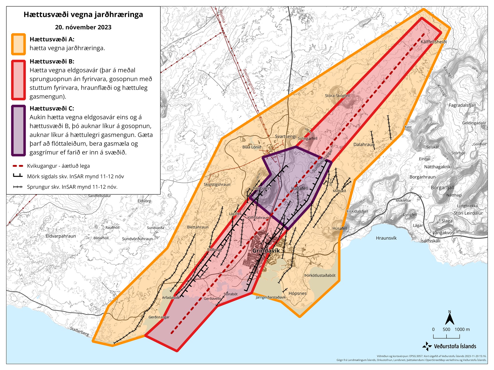
The IMO, in collaboration with specialists from the University of Iceland, will continue to monitor the area as effectively as possible, constantly re-evaluating and interpreting the data received.
As mentioned before, the Icelandic Meteorological Office has increased surveillance in and around Grindavík and the area around Hagafell, while residents approach their properties and contractors work on protective measures. The effectiveness of this surveillance depends on the high sensitivity of earthquake and real-time GPS measurements, which are highly dependent on weather conditions. Given the weather forecast for the next two days, which indicates precipitation and significant wind, it can be expected that both the sensitivity of earthquake detection and real-time GPS monitoring by the IMO will be affected. Waves affects the low-frequency signals in the seismometers where waves appear as noise. Fog and dark hail also affect the visual confirmation of the eruption with cameras.
Source : IMO.
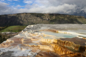
Colombia , Purace – Los Coconucos Los Coconucos Volcanic Range :
Popayan, November 21, 2023, 4:30 p.m.
Weekly bulletin of the activity of the Puracé volcano – Los Coconucos volcanic chain
From the monitoring of the activity of the VOLCANIC CHAIN PURACE VOLCANO – LOS COCONUCOS, the MINISTRY OF MINES AND ENERGY through the COLOMBIAN GEOLOGICAL SERVICE (SGC) reports that:
During the week of November 14-20, 2023, an increase in seismic activity occurred, notably on the 16th at 7:29 p.m. (local time), where a significant increase in seismic events related to the movement of fluids in volcanic conduits , located mainly under the crater of the Puracé volcano, and inside which a seismic signal associated with the emission of ash and gas into the atmosphere was produced. The next day, a report of observation of ash deposited on the northern flank of the Puracé volcano was received. On the other hand, localized deformations continue to be recorded between the Puracé and Curiquinga volcanoes. In addition, stable values were recorded in the flow of sulfur dioxide (SO2), while the concentration values of carbon dioxide (CO2) continue to be high, compared to what was recorded until present this year.
The images obtained using the installed cameras show an increase in degassing of the volcanic system, both inside the crater and in the external lateral fumarole (north-west flank of the volcanic edifice), reaching in the latter column heights of 700 m above the crater. The analyzed satellite information does not show significant temperature changes in the lateral zone of the fumaroles or inside the crater.
The other parameters measured and used for the diagnosis of volcanic activity showed no notable changes during the period evaluated.
The alert status for volcanic activity remains at: YELLOW ALERT: ACTIVE VOLCANO WITH CHANGES IN THE BEHAVIOR OF THE BASE LEVEL OF MONITORED PARAMETERS AND OTHER MANIFESTATIONS.
Source et photo : SGC
Hawaii , Kilauea :
Tuesday, November 21, 2023, 10:30 AM HST (Tuesday, November 21, 2023, 20:30 UTC)
19°25’16 » N 155°17’13 » W,
Summit Elevation 4091 ft (1247 m)
Current Volcano Alert Level: ADVISORY
Current Aviation Color Code: YELLOW
Activity Summary:
Kīlauea volcano is not erupting. The unrest associated with the intrusion that began in early October southwest of Kīlauea’s summit increased this morning November 21. Seismic activity in the south part of Kīlauea’s caldera, which has been elevated over the last week, increased in the early morning hours and was followed by a cluster of earthquakes around 8 a.m. in the upper East Rift Zone. Unrest may continue to wax and wane with changes to the input of magma into the area and eruptive activity could occur in the near future with little or no warning. No unusual activity has been noted along the middle and lower sections of Kīlauea’s East Rift Zone.
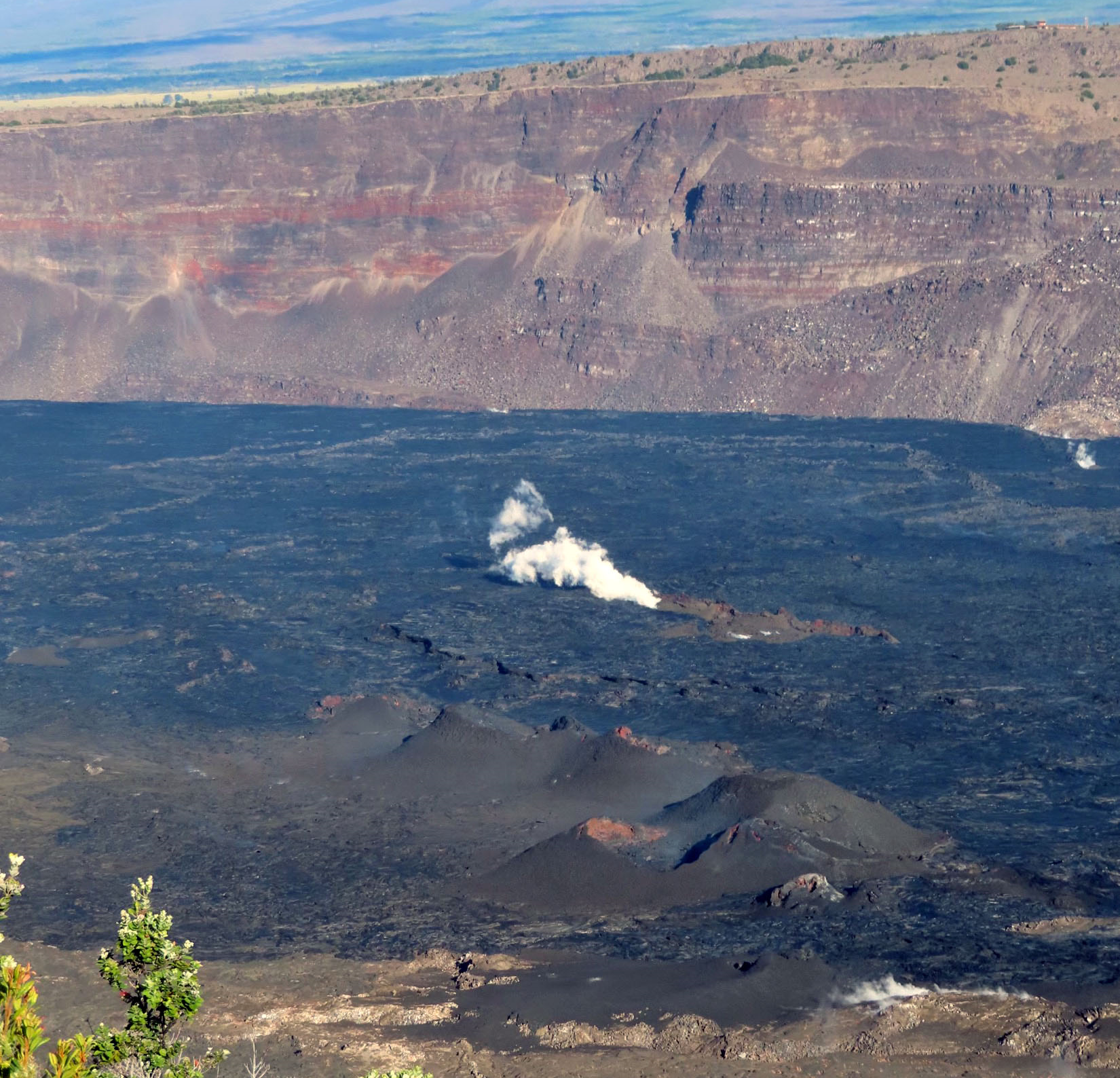
Summit Observations:
A new episode of earthquake activity began this morning Monday, November 21, in the south caldera, and upper East Rift Zones. Fourty-five earthquakes were observed in the southern part of the caldera including two magnitude 2.8 quakes in the past 24 hours along with twenty five earthquakes in the upper East Rift Zone. The new episode of earthquake activity in the upper East Rift Zone began around 8 a.m. this morning Tuesday November 21 between Puhimau and Hiiaka Craters. The largest earthquakes were magnitude 3.2 and 2.8 accompanied by many smaller earthquakes not located on maps.
The Uēkahuna summit tiltmeter, located northwest of the caldera had a modest increase in tilt in the past 24 hours. The Sand Hill tiltmeter, located southwest of the caldera, had moderate observable inflation in the last 24 hours. However, overall, the summit of Kīlauea remains at a high level of inflation, above the level reached prior to the most recent eruption in September 2023.
Sulfur dioxide (SO2) emission rates remain low. Field observations found SO2 gas emmision of 100 tonnes per day on November 17th. This is the same as an observation in October 2023.
Source : HVO
Photo : USGS / J. Chang