November 05 , 2023.
Japan , Iwo-Jima :
Eruptions from an undersea volcano continued spewing plumes of smoke and ash Nov. 3 around a new islet taking shape off the coast of distant Iwoto island in the Pacific Ocean.
The volcanic activity is occurring in the Ogasawara island chain, some 1,200 kilometers south of Tokyo.
Along with the cooling magma thrown up by the eruptions, pumice started creating a small hill on the emerging islet.
The activity has shifted to one of continuous eruptions,” said Setsuya Nakada, professor emeritus of volcanic geology at the University of Tokyo, who was aboard an Asahi Shimbun plane that flew over the islet on Nov. 3.
“It will likely move to one in which lava starts spewing out,” he said.
The eruptions began in late October a few hundreds of meters off the southern coast of Iwoto, formerly known as Iwojima, the site of a major battle in World War II.
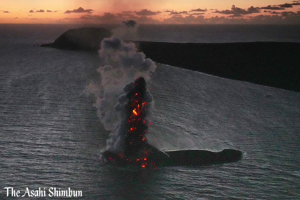
Eruptions were observed at roughly one-minute intervals. Volcanic ash thrown up into the air reached heights about five times that of 169-meter-high Mount Suribachi on Iwoto.
Floating bands of brown pumice were also observed in the surrounding waters.
“This is moving from steam eruptions caused by magma coming into contact with seawater to one in which magma is directly spewed out,” Nakada said.
He also noted horizontal spewing of volcanic smoke caused by the violent eruptions.
Iwoto is one of 111 active volcanoes in Japan and as such the Japan Meteorological Agency has set up an around-the-clock observation system for volcanic activity.
The surface of Iwoto continues to rise at a pace of one meter a year, a sign of extremely strong volcanic activity.
Eruptions involving magma are thought to have begun between July and August 2022, the first eruptions on Iwoto in around 1,000 years.
The Maritime Self-Defense Force has a base on Iwoto, but otherwise the island is uninhabited
Source : The Asahi Shimbun
Photo : Kotaro Ehara.
Iceland , Reykjanes Peninsula :
Volcanic unrest continues on the Reykjanes Peninsula . Around 800 earthquakes in the area yesterday . Updated 4. November at 11:30pm .
After 17:30 yesterday, seismic activity decreased considerably. In the last 12 hours, about 900 earthquakes have been detected, all under M3.0. The activity after midnight as mainly been located at Sundhnjúkagígar – NE of Þorbjörn, as well as west of Eldvörp.
Seismicity has decreased considerably since yesterday, but the development of earthquake magnitudes, number of earthquakes and their location is comparable to the development previously seen related to magma accumulation in the vicinity of Þorbjörn.
The latest deformation data shows that uplift continues in the area. This uplift is thought to be due to magma accumulation NW of Þorbjörn at 4-5 km depth. While that magma accumulation continues, increased seismicity in the area can be expected from increased stresses in the crust. Rockfall can occur following large earthquakes, so caution should be taken by steep slopes
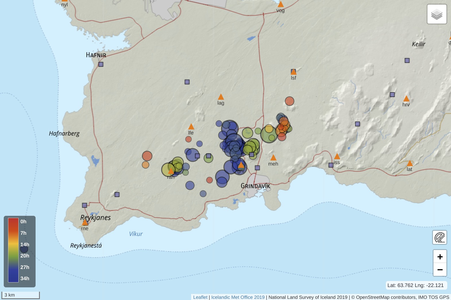
Earthquakes (circles) with magnitude over 1.5, from midnight on 3 November until 10:45 on the 4 November. The colour bar to the left shows the time of the earthquakes and the size of the circles represents the relative size of the events. Locations of seismic stations (triangles) and GPS deformation stations (squares) are also shown.
The Icelandic Meteorological Office continues to monitor the area closely and to meet with the Civil protection agency to discuss the situation. Signs of magma coming towards the surface would appear as increased, shallower seismicity and rapid crustal deformation at the surface as well as volcanic tremor, which is a high rate of many small earthquakes. At the moment no clear signs can be seen of any of this, but the situation can change on short notice.
Source et photo : IMO
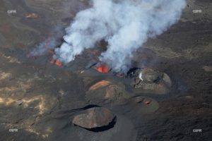
Hawaii , Kilauea :
Saturday, November 4, 2023, 9:33 AM HST (Saturday, November 4, 2023, 19:33 UTC)
19°25’16 » N 155°17’13 » W,
Summit Elevation 4091 ft (1247 m)
Current Volcano Alert Level: ADVISORY
Current Aviation Color Code: YELLOW
Activity Summary:
Kīlauea volcano is not erupting. The unrest at and near Kīlauea’s summit has continued over the past 24 hours, with a decrease in seismicity, in association with an intrusive event that began in early October. Unrest may continue to wax and wane with changes to the input of magma into the area. The summit of Kīlauea remains at a moderate to high level of inflation and eruptive activity is possible in the coming weeks or months. No unusual activity has been noted along Kīlauea’s East Rift Zone or the Southwest Rift Zone.
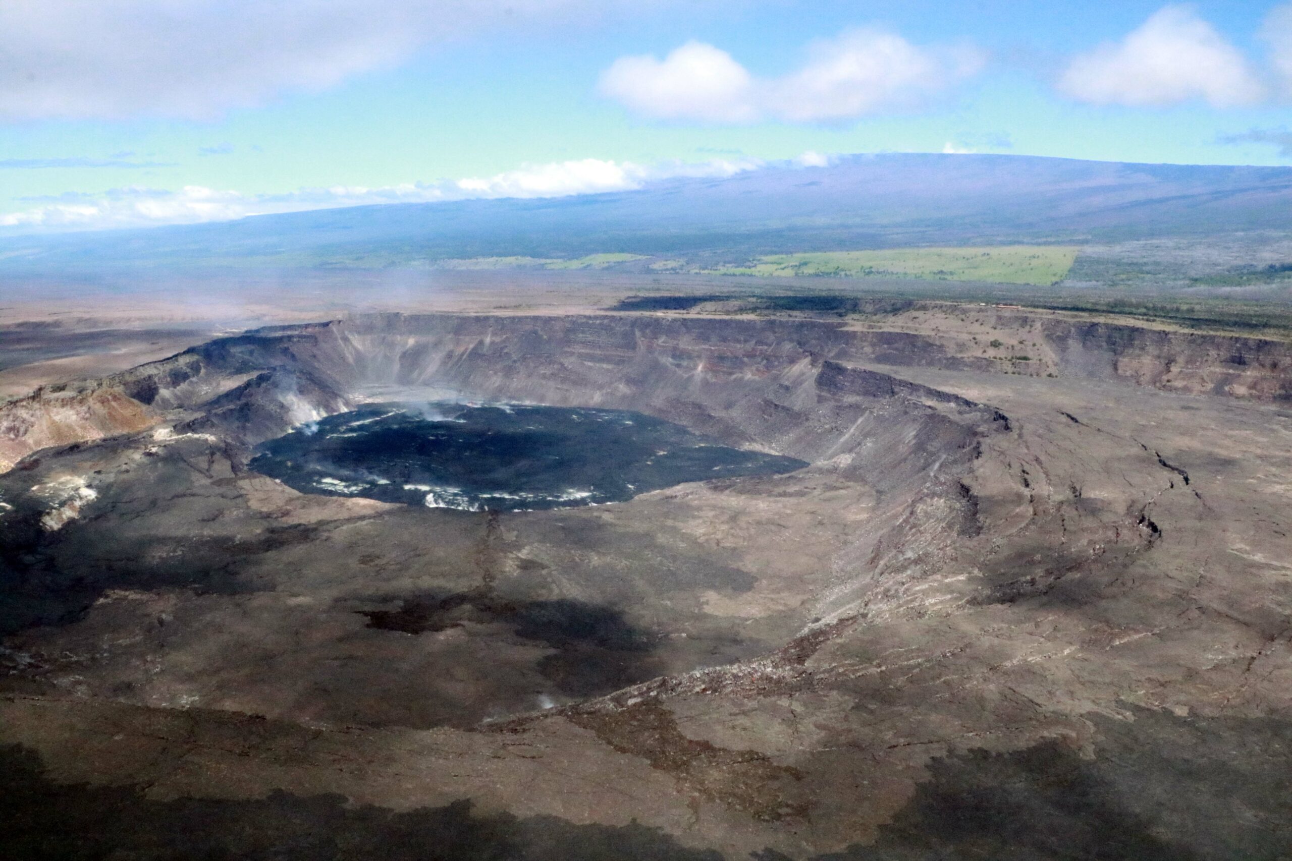
Summit Observations:
Unrest around the summit area of Kīlauea continued over the past day with a decrease in the level of seismicity. Waxing and waning of unrest may continue.
Elevated seismicity associated with an intrusion beneath the south-southwest region of Kīlauea’s summit began in early October with the greatest number of earthquakes occurring on October 4-6, 16-18, 21-23, and 26-30. Over the past 24 hours, seismic activity decreased, with approximately 3 earthquakes recorded in Kīlauea’s summit region, a slight decrease from approximately 11 over the previous 24 hours. Most of the earthquakes related to this unrest have been smaller than magnitude-2 and have occurred at depths of around 1–3 km (0.6–2 mi) below the surface.
The Uēkahuna summit tiltmeter, located northwest of the caldera remained stable and measured nearly no deformation over the last 24 hours. The Sand Hill tiltmeter, located southwest of the caldera, has measured gradual, slight deflation since October 31. Overall, he current rate of inflation (as measured by GPS and tiltmeters) at the summit of Kīlauea has diminished significantly over the last several of days.
Sulfur dioxide (SO2) emission rates remain low and were measured at a rate of about 100 tonnes per day on October 19, 2023.
Source : HVO.
Photo : USGS/ K. Mulliken
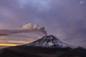
Indonesia , Ibu :
Mount Ibu erupted on Friday, November 3, 2023 at 7:20 p.m. WIT. The height of the eruptive column was observed to be ± 1,200 m above the peak (± 2,525 m above sea level). The ash column was observed to be gray with thick intensity, oriented towards the Northeast. The eruption was recorded on a seismograph with a maximum amplitude of 28 mm and a duration of 89 seconds.
VOLCANO OBSERVATORY NOTICE FOR AVIATION – VONA
Issued : November 03 , 2023
Volcano : Ibu (268030)
Current Aviation Colour Code : ORANGE
Previous Aviation Colour Code : orange
Source : Ibu Volcano Observatory
Notice Number : 2023IBU052
Volcano Location : N 01 deg 29 min 17 sec E 127 deg 37 min 48 sec
Area : North Maluku, Indonesia
Summit Elevation : 4240 FT (1325 M)
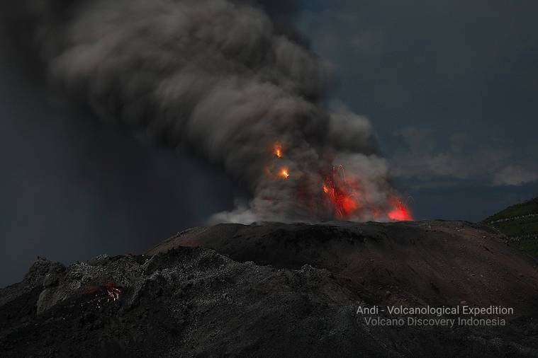
Volcanic Activity Summary :
Eruption with volcanic ash cloud at 10h20 UTC (19h20 local).
Volcanic Cloud Height :
Best estimate of ash-cloud top is around 8080 FT (2525 M) above sea level or 3840 FT (1200 M) above summit. May be higher than what can be observed clearly. Source of height data: ground observer.
Other Volcanic Cloud Information :
Ash cloud moving to northeast. Volcanic ash is observed to be gray. The intensity of volcanic ash is observed to be thick.
Remarks :
Eruption recorded on seismogram with maximum amplitude 28 mm and maximum duration 89 second.
Source : Magma Indonesie
Photo : Andi Rosati / Volcanodiscovery.( archive).
Vanuatu , Ambrym :
The Vanuatu Meteorology and Geo-Hazards Department (VMGD) reported ongoing volcanic earthquakes and tremors at Ambrym during October. Volcanic activity increased for a few hours during 22-23 October and diffuse gas emissions were detected in satellite data on 23 October. The Alert Level was lowered to 1 (on a scale of 0-5) on 28 April. VMGD warned the public to stay outside of Permanent Danger Zone A, defined as a 1-km radius around Benbow Crater and a 2-km radius around Marum Crater, and additionally to stay 500 m away from the ground cracks created by the December 2018 eruption.
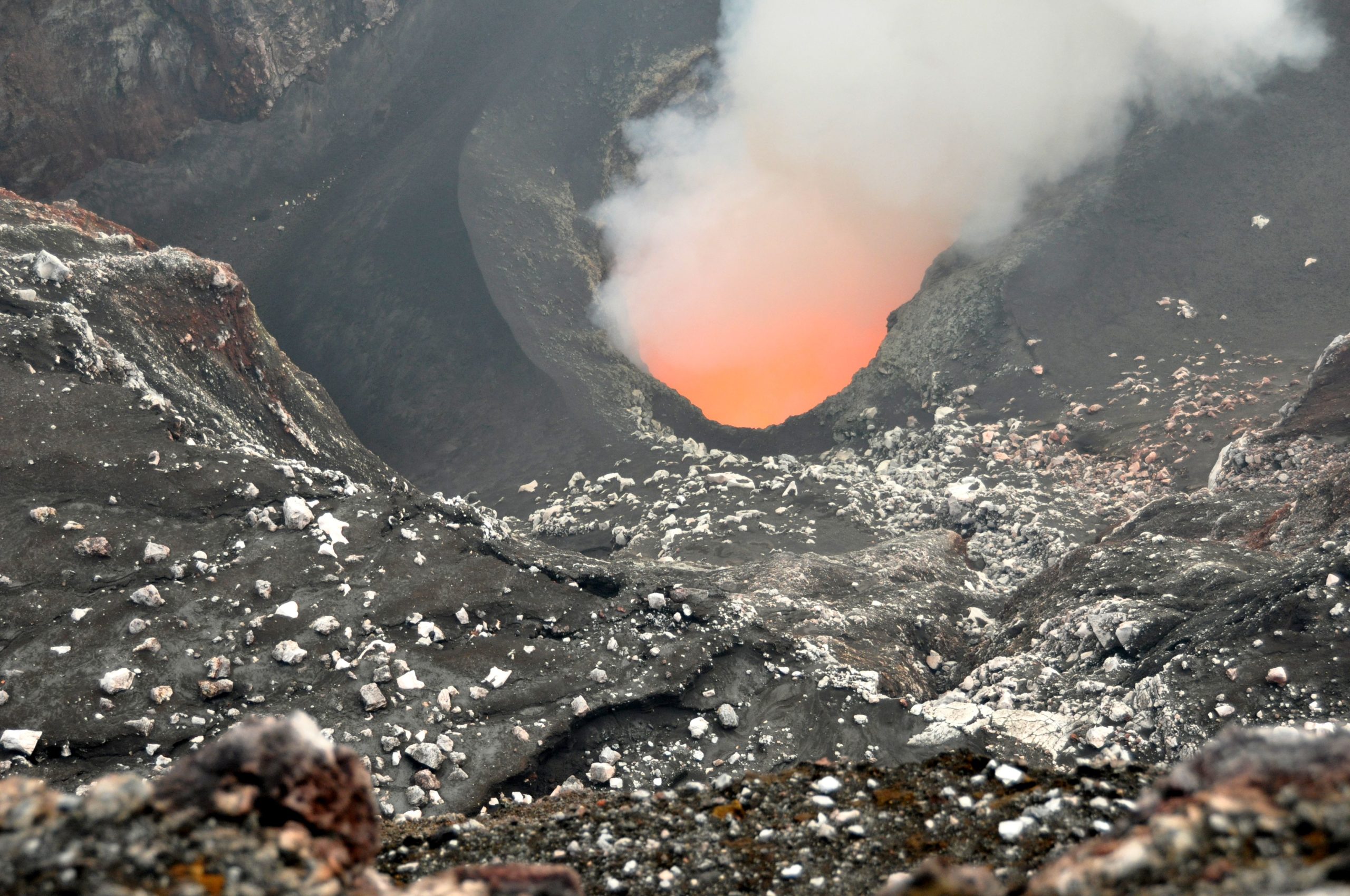
Ambrym, a large basaltic volcano with a 12-km-wide caldera, is one of the most active volcanoes of the New Hebrides Arc. A thick, almost exclusively pyroclastic sequence, initially dacitic then basaltic, overlies lava flows of a pre-caldera shield volcano. The caldera was formed during a major Plinian eruption with dacitic pyroclastic flows about 1,900 years ago. Post-caldera eruptions, primarily from Marum and Benbow cones, have partially filled the caldera floor and produced lava flows that ponded on the floor or overflowed through gaps in the caldera rim. Post-caldera eruptions have also formed a series of scoria cones and maars along a fissure system oriented ENE-WSW. Eruptions have apparently occurred almost yearly during historical time from cones within the caldera or from flank vents. However, from 1850 to 1950, reporting was mostly limited to extra-caldera eruptions that would have affected local populations.
Source: Vanuatu Meteorology and Geo-Hazards Department (VMGD) , GVP.
Photo : G Vitton / Le chaudron de Vulcain ( archive).