October 17 , 2023.
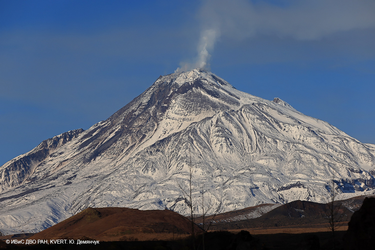
Kamchatka , Bezymianny :
VOLCANO OBSERVATORY NOTICE FOR AVIATION (VONA)
Issued: October 17 , 2023
Volcano: Bezymianny (CAVW #300250)
Current aviation colour code: ORANGE
Previous aviation colour code: orange
Source: KVERT
Notice Number: 2023-115
Volcano Location: N 55 deg 58 min E 160 deg 35 min
Area: Kamchatka, Russia
Summit Elevation: 2882 m (9452.96 ft)
Volcanic Activity Summary:
An extrusive eruption of the volcano continues. Satellite data by KVERT showed an ash plume extending about 86 km to the north-east of the volcano.
An extrusive eruption of the volcano continues. Ash explosions up to 10-15 km (32,800-49,200 ft) a.s.l. could occur during next 1-3 days. Ongoing activity could affect international and low-flying aircraft.
Volcanic cloud height:
4000-4500 m (13120-14760 ft) AMSL Time and method of ash plume/cloud height determination: 20231017/0450Z – Himawari-9 14m15
Other volcanic cloud information:
Distance of ash plume/cloud of the volcano: 86 km (53 mi)
Direction of drift of ash plume/cloud of the volcano: NE / azimuth 38 deg
Time and method of ash plume/cloud determination: 20231017/0450Z – Himawari-9 14m15
Source : Kvert
Photo : Yu. Demyanchuk. IVS FEB RAS, KVERT
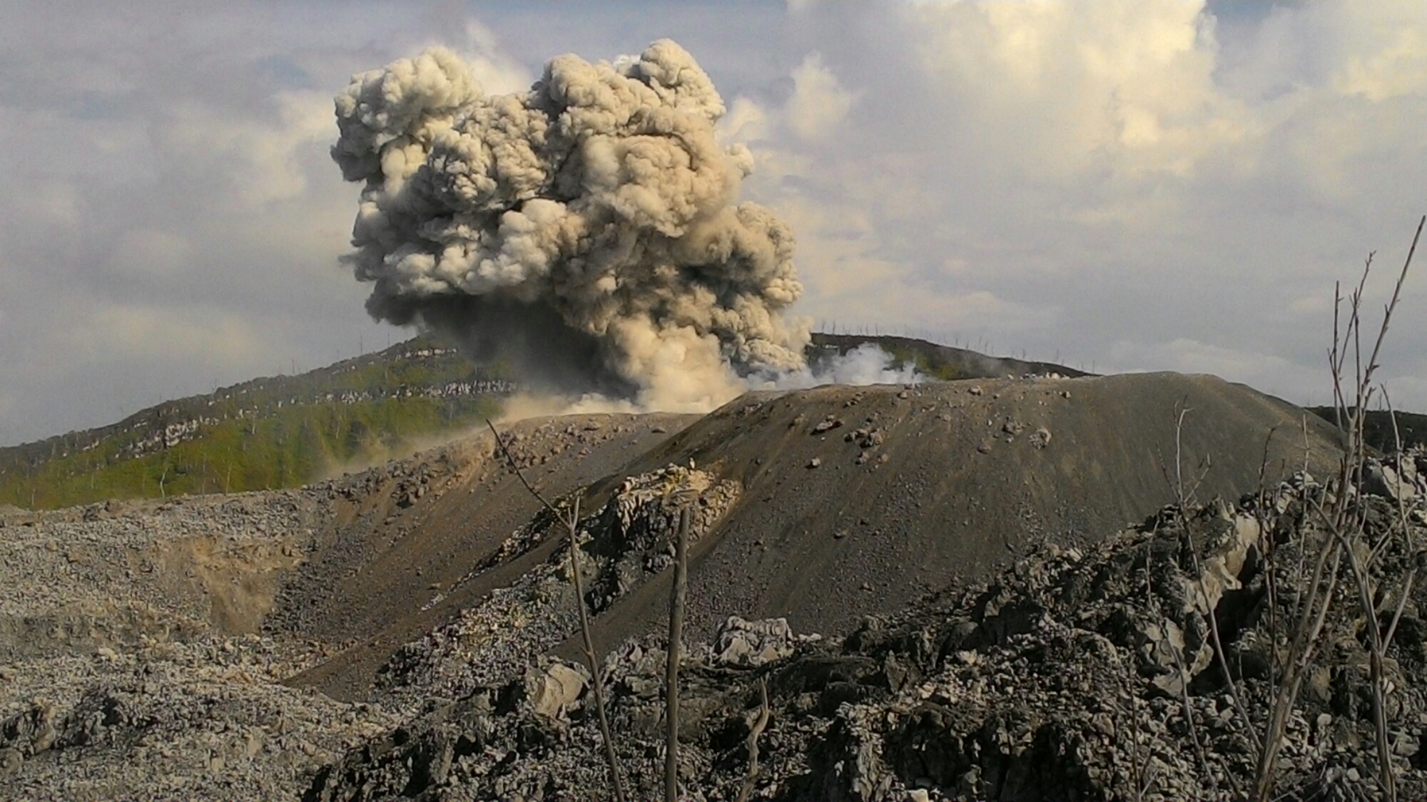
Indonesia , Ibu :
Mount Ibu exhibited an eruption on Tuesday, October 17, 2023 at 12:42 p.m. WIT with the height of the ash column observed at ±600 m above the summit (±1925 m above sea level). The ash column was observed to be gray with thick intensity, oriented towards the East. This eruption was recorded on a seismograph with a maximum amplitude of 28 mm and a duration of 57 seconds.
VOLCANO OBSERVATORY NOTICE FOR AVIATION – VONA
Issued : October 17 , 2023
Volcano : Ibu (268030)
Current Aviation Colour Code : ORANGE
Previous Aviation Colour Code : orange
Source : Ibu Volcano Observatory
Notice Number : 2023IBU041
Volcano Location : N 01 deg 29 min 17 sec E 127 deg 37 min 48 sec
Area : North Maluku, Indonesia
Summit Elevation : 4240 FT (1325 M)
Volcanic Activity Summary :
Eruption with volcanic ash cloud at 03h42 UTC (12h42 local).
Volcanic Cloud Height :
Best estimate of ash-cloud top is around 6160 FT (1925 M) above sea level or 1920 FT (600 M) above summit. May be higher than what can be observed clearly. Source of height data: ground observer.
Other Volcanic Cloud Information :
Ash cloud moving to east. Volcanic ash is observed to be gray. The intensity of volcanic ash is observed to be thick.
Remarks :
Eruption recorded on seismogram with maximum amplitude 28 mm and maximum duration 57 second.
Source : Magma Indonésie.
Photo : John Massolo – WordPress.com
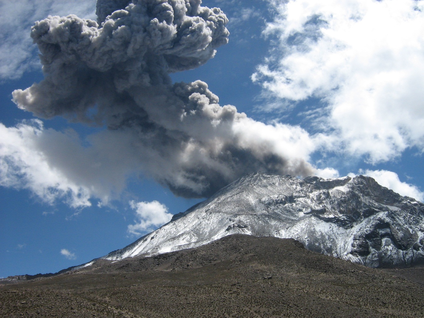
Peru , Ubinas :
Analysis period: from October 10, 2023 to October 15, 2023. Arequipa, October 16, 2023.
Alert level: ORANGE
The Geophysical Institute of Peru (IGP) reports that the eruptive processes of the Ubinas volcano (Moquegua region) maintain low to moderate levels. During this period, slight emissions of ash, gas and steam were recorded which reached up to 700 m above the summit of the volcano, with seismic activity linked to magmatic fluids. Consequently, the Orange volcanic alert level is maintained.
During the analysis period, the occurrence of 225 volcano-tectonic (VT) type earthquakes was detected, associated with rock rupture processes that occur inside the volcano. In addition, 34 seismic signals were recorded, associated with the movements of volcanic fluids (gas and magma). On October 11 at 3:55 p.m., a signal associated with a volcanic ash pulse was recorded.
Surveillance cameras made it possible to identify emissions of ash (October 11) of gas and water vapor which reached heights of 700 m above the summit of the volcano, which were dispersed mainly towards the western sectors and southwest of the Ubinas volcano. On the other hand, monitoring of the deformation of the volcanic structure shows variations of less than 5 mm of displacement (slight tendency towards inflation). Satellite monitoring has not shown thermal anomalies in the Ubinas crater.
RECOMMENDATIONS
• Keep the volcanic alert level at ORANGE level.
Source : Cenvul.
Photo : Archive , Auteur inconnu.
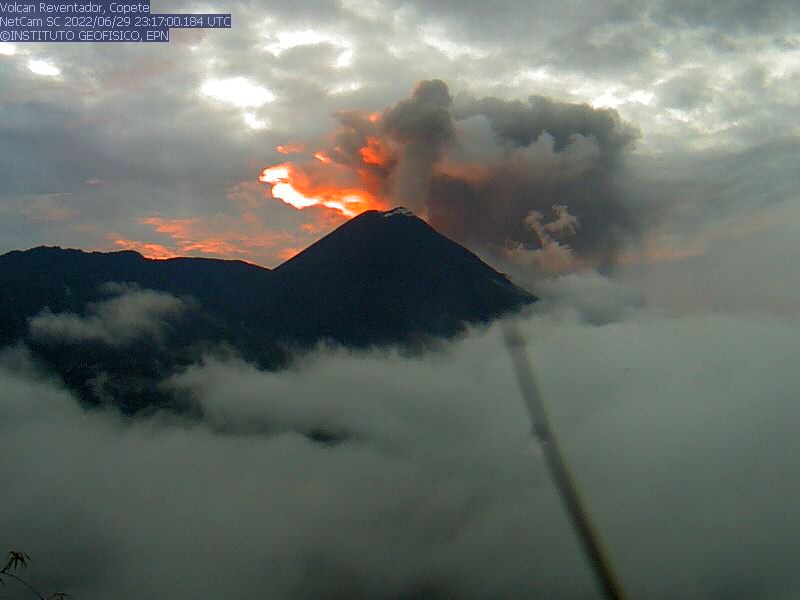
Ecuador , Reventador :
DAILY REPORT ON THE STATE OF THE REVENTADOR VOLCANO, Monday October 16, 2023.
Information Geophysical Institute – EPN.
Surface activity level: High, Surface trend: No changes
Internal activity level: Moderate, Internal trend: No changes
Seismicity: From October 15, 2023, 11:00 a.m. to October 16, 2023, 11:00 a.m.:
The following table shows the number of seismic events from the reference station in the last 24 hours.
Explosion (EXP) 43
Long Period (LP) 29
Transmitting Tremor (TREMI) 2
Precipitation/Lahars:
Rainfall is not recorded. **In the event of heavy rains, these could remobilize the accumulated materials, generating mud and debris flows which would descend the sides of the volcano and flow into adjacent rivers.
Emissions/ash column:
Several emissions were observed with varying amounts of ash and with heights up to 600 m above the crater level, with directions to the West and Southwest.
Other monitoring parameter:
The FIRMS satellite system recorded 3 thermal anomalies in the last 24 hours.
Observation:
During yesterday night and early today, luminosity was observed at the crater level and the descent of incandescent material along all flanks of the volcano was recorded up to 800 m below the crater level. At the moment, the volcanic area is cloudy.
Alert level: Orange.
Source : IGEPN.
Photo : archive IGEPN
Italy , Campi Flegrei :
CAMPI FLEGREI – REPORT ON SEISMIC AND SWARM EVENT .
We inform you that at 12:36 local time on 10/16/2023, a seismic event was recorded in the Campi Flegrei area (Solfatara) with magnitude Md=3.6 ± 0.3. See the exact location on the attached map.
From the same moment (12:36 p.m.) a seismic swarm began.
Updates will follow depending on the evolution of the phenomenon. More information on the Vesuvius Observatory website, GOSSIP database.
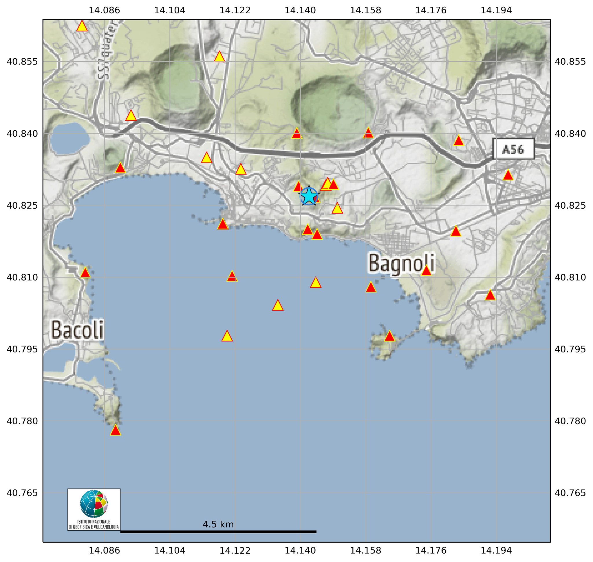
Update on the Campi Flegrei earthquake, 16.10.2023, 16.04.
From 12.36 on 10/16/2023 there was an earthquake in the Campi Flegrei region. At 16.04 hours 8 earthquakes with magnitude Md ≥ 0.0 and maximum magnitude Md = 3.6 ± 0.3.
PRESS RELEASE OF END OF SEISMIC SWARM in Campi Flegrei, 16.10.2023, 5:28 p.m.
We announce the conclusion of the seismic swarm which began at 12:36 p.m. on 10/16/2023 and was preliminarily composed of 8 earthquakes of magnitude Md ≥ 0.0 and maximum magnitude Md = 3.6 ± 0, 3 located in the Campi Flegrei area.