June 09 , 2021.
Italy / Sicily , Etna :
Press release on ETNA’s activity, June 08, 2021, 02:35 (00:35 UTC).
The National Institute of Geophysics and Volcanology, Osservatorio Etneo, announces that from approximately 11:10 UTC, the images of the surveillance cameras show Strombolian activity with ash emission associated with the Southeast Crater. Based on a forecast model, the eruptive cloud produced by this activity disperses to the east.
The average amplitude of the volcanic tremor shows some slight fluctuations and remains in the range of average values. The center of gravity of volcanic tremor sources is located in the Southeast Crater area at an altitude of 2800-2900 m above sea level. Infrasound activity remains at low levels.
No significant changes are observed in the time series of soil deformation monitoring stations.
Press release on ETNA’s activity, 08 June 2021, 20:30 (18:30 UTC).
The National Institute of Geophysics and Volcanology, Osservatorio Etneo, announces that during the day, the average amplitude of the volcanic tremor showed continuous fluctuations, with maximum values gradually increasing. From around 17:20 UTC it reached high values. The center of gravity of volcanic tremor sources is
located in the Southeast Crater area at an altitude of 2800-2900 m above sea level. Infrasound activity remains at low levels.
From the surveillance cameras, it was possible to observe that the weak Strombolian activity at the level of the Southeast Crater, reported in the previous press release, continued throughout the day with varying intensity. This activity continues to produce occasional ash emissions which disperse rapidly in the summit area.
No significant changes are observed in the time series of soil deformation monitoring stations.
Further updates will be communicated shortly.
Weekly bulletin from May 31, 2021 to June 06, 2021 (issue date June 08, 2021)
SUMMARY OF ACTIVITY
In view of the monitoring data, it is highlighted:
1) VOLCANOLOGICAL OBSERVATIONS: Eruptive episodes at the Southeast Crater; occasional ash emissions at the Northeast Crater; pulsed degassing and emissions of diluted ash at the Bocca Nuova crater; ordinary degassing at the Voragine crater.
2) SEISMOLOGY: Weak seismic activity of fracturing; average amplitude of the volcanic tremor variable between low, medium and high level, with maximum values recorded during paroxysmal events.
3) INFRASOUND: high infrasound activity in conjunction with the lava fountain episodes at the Southeast Crater, low in the remaining period.
4) DEFORMATIONS: The soil deformation monitoring networks do not show any substantial variations, except for those observed by the inclinometric network during lava fountains.
5) GEOCHEMISTRY: The flow of SO2 at an average level with medium-high intraday values
HCl flux at medium-low level
The CO2 flux from the soil has shown increasing values since April, settling on an average degassing regime.
The partial pressure of dissolved CO2 in the aquifer does not show significant variations.
No new C / S ratio data is available.
Helium isotope ratio no longer shows decreases compared to previous data remaining on average values
6) SATELLITE OBSERVATIONS: The thermal activity in the summit area was high to very high in correspondence with the lava fountains.
VOLCANOLOGICAL REMARKS
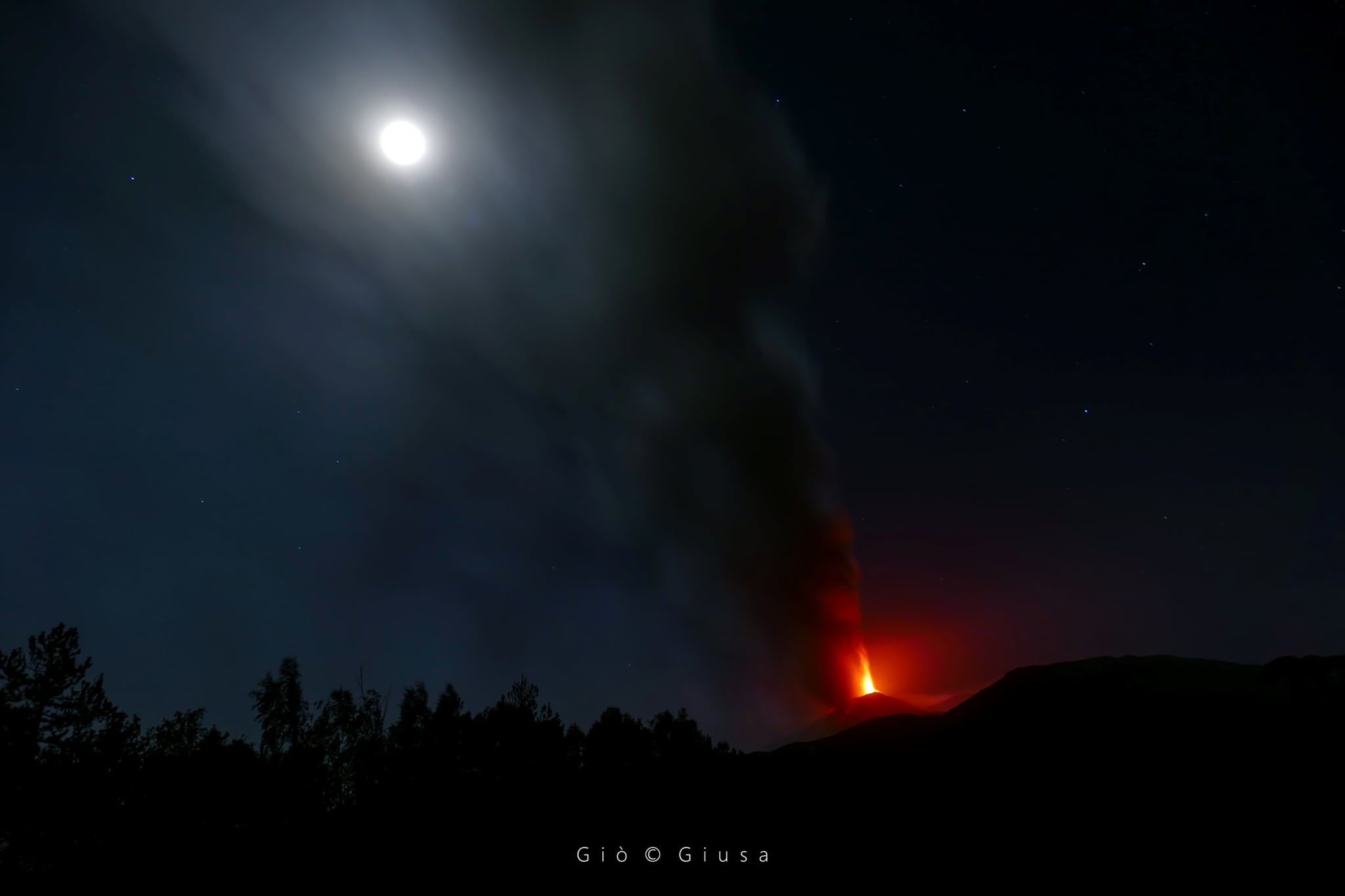
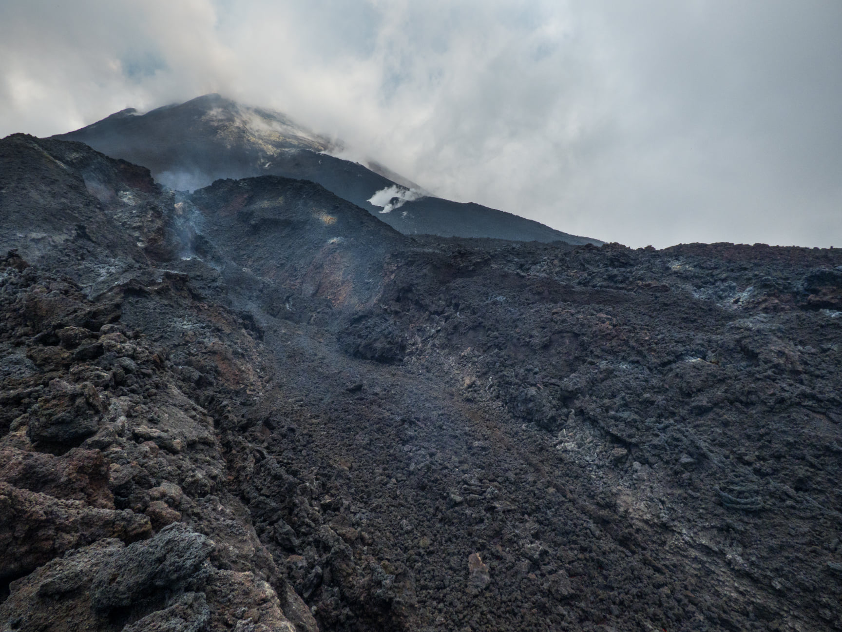
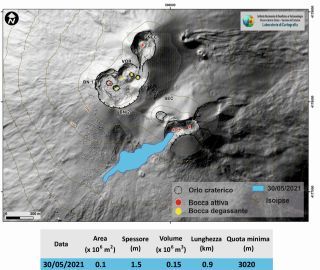
After the last lava fountain episode, from May 31, the activity of the Southeast Crater was characterized by occasional ash emissions which quickly dispersed near the summit area. On the morning of June 2, from the surveillance cameras, the resumption of a weak Strombolian activity visible on the surface was observed which produced discontinuous and light emissions of diluted ash. This activity intensified from 08:00 UTC, to pass in about 30 minutes to the lava fountain stage lasting about 2.15 hours. The fountain fed an eruptive cloud which reached a height of about 5 to 6 km above sea level. INGV field staff reported a drop in products north of Zafferana, in the town of Petrulli and in Santa Venerina. The lava fountain had produced an overflow of lava from the southern slope of the Southeast Crater which had spread to the west and which, on the morning of June 4, was cooling. By 10:45 UTC, the lava fountain was over.
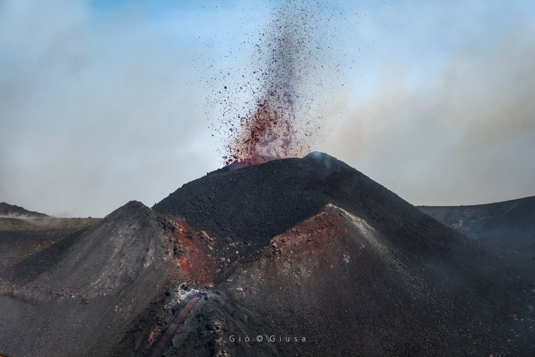
From 18:50 UTC on June 2 and between June 3 and 4 in the morning, the Southeast Crater fed a weak continuous Strombolian intracrater activity observable at night. From 1:30 p.m. UTC on June 4, the increase in activity produced discontinuous ash emissions and, from 4:04 p.m. UTC, also fueled an overflow of lava that spread along the southern slope of the Crater. South-East to South-West. From approximately 4:20 p.m. UTC, the transition of Strombolian activity to the lava fountain stage was observed. The latter fed an eruptive cloud which dispersed in a south-easterly direction reaching a height of about 6.5 km above sea level. By 5:30 p.m. UTC, the lava fountain had gradually depleted. INGV staff on the ground reported an ash fall in Aci Castello, Acitrezza, San Giovanni La Punta, Tremestieri, Catania, Viagrande, between Pedara, Fleri and Syracuse. At around 9:00 p.m. UTC, based on surveillance camera images, it was observed that in the proximal area, the lava overflow was still fed and its front was at an altitude of about 2,800 m. Between June 4 and 5, the Southeast Crater produced discontinuous ash emissions, which gradually decreased in intensity. At 11:40 UTC on June 5, these emissions were occasional, very light and dispersed rapidly in the summit area. The lava overflow front had stopped, settling at the same elevation as the day before.
During the observation period, the Northeast Crater was characterized by degassing activities, with the exception of June 4, where it produced occasional ash emissions which quickly dispersed in the summit area. . The Bocca Nuova exhibited pulsed degassing sometimes associated with sporadic and light emissions of diluted ash. The Voragine supplied an ordinary degassing system.
Source : INGV.
Photos : Gio Giusa , INGV , Gio Giusa ( Voragine).
Peru , Sabancaya :
Analysis period: May 31, 2021 to June 06, 2021, Arequipa, June 07, 2021.
Alert level: ORANGE
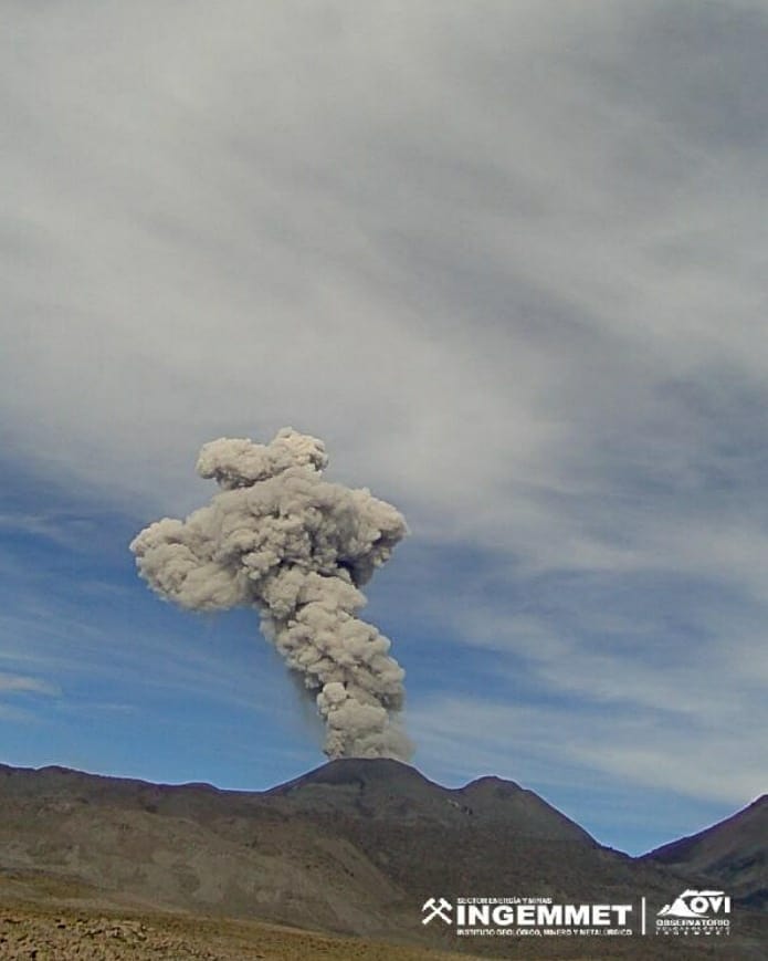
The Geophysical Institute of Peru (IGP) reports that the eruptive activity of the Sabancaya volcano remains at moderate levels, that is, with the recording of an average of 96 daily explosions, with columns of ash and gas up to 4 km altitude above the summit of the volcano and their consequent dispersion. Therefore, for the following days, no significant change is expected in eruptive activity.
The IGP recorded and analyzed the occurrence of 716 earthquakes of volcanic origin, associated with the circulation of magmatic fluids within the Sabancaya volcano. An average of 96 explosions was recorded daily. During this period, Volcano-Tectonic (VT) earthquakes associated with rock fractures were located mainly in the Northeast, North, and Northwest of Sabancaya and presented magnitudes between M1.0 and M3.5.
The monitoring of the deformation of the volcanic structure using GNSS techniques (processed with fast orbits) does not present any significant anomalies. However, in general, an inflation process was observed in the northern sector (around the Hualca Hualca volcano). Visual surveillance identified columns of gas and ash up to 4 km altitude above the summit of the volcano, which were scattered towards the South-East, South, East and North-East sectors of Sabancaya. Satellite recordings have identified the presence of 6 thermal anomalies (maximum value of 16 MW) associated with the presence of a lava body on the surface of the volcano’s crater.
RECOMMENDATIONS
• Keep the volcanic alert level in orange.
• Do not approach within a radius of 12 km from the crater.
Source : IGP.
Photo : Ingemmet
New Zealand , Ruapehu :
Mt Ruapehu status update: volcanic activity remains at low level, Crater Lake (Te Wai ā-moe) down to 26°C . Published: Tue Jun 8 2021 3:30 PM
Following the period of heightened unrest activity in December 2020, volcanic activity at Mt Ruapehu has remained at a low level over the past six months, with gas emissions, lake chemistry and volcanic tremor all within typical ranges. After the December period of high temperatures, Crater Lake (Te Wai ā-moe) cooled then reheated in early April before cooling again now to around 26°C. The Volcanic Alert Level at Mt Ruapehu remains at Level 1.
In December 2020, we observed elevated volcanic activity at Mt Ruapehu, raising the Volcanic Alert Level (VAL) to 2. This unrest declined in January and the Volcanic Alert Level was lowered back to Level 1 on 11 January 2021. The Crater Lake (Te Wai ā-moe) temperature cooled to around 30°C in February-March.

Since the December 2020 period of elevated unrest we have conducted routine monitoring gas measurement flights and Crater Lake (Te Wai ā-moe) water samplings. The results from these visits and of our continuous monitoring of volcanic earthquake activity, tremor levels, and Crater Lake (Te Wai ā-moe) temperature and water level indicate that key monitoring parameters remain within normal ranges.
The largest observed variation in activity over the past several months has been the crater lake temperature. It was over 43ºC in early January 2021 then cooled to around 30ºC in February-March, before reheating again to just over 40ºC in early April. Since then, it has cooled again to 26ºC in recent weeks.
To maintain the lake water temperature at around 40ºC our modelling indicates that ~400 MW (megawatt) of heat was entering the lake. The heat input is currently about 100MW.
All these observations suggest that volcanic unrest activity remains at low levels at Mt Ruapehu.
The Volcanic Alert Level remains at Level 1 which reflects the current level of volcanic unrest. Mt Ruapehu is an active volcano and has the potential to erupt with little or no warning when in a state of volcanic unrest. The Aviation Colour Code remains colour Green.
The Volcanic Alert Level should not be used to forecast future activity, however at Volcanic Alert Level 1, eruptions are less likely than at Volcanic Alert Level 2.
Source : Geonet .
Photo : Brad Scott / GNS
Alaska , Gareloi :
AVO/USGS Volcanic Activity Notice
Current Volcano Alert Level: ADVISORY
Previous Volcano Alert Level: NORMAL
Current Aviation Color Code: YELLOW
Previous Aviation Color Code: GREEN
Issued: Tuesday, June 8, 2021, 9:43 AM AKDT
Source: Alaska Volcano Observatory
Notice Number: 2021/A338
Location: N 51 deg 47 min W 178 deg 47 min
Elevation: 5161 ft (1573 m)
Area: Aleutians
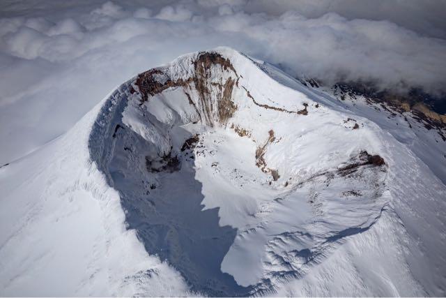
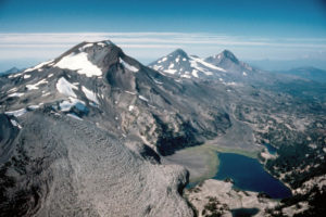
Aerial photograph of Gareloi volcano’s summit crater, looking north-northwest. Since the 1940s, the crater has been alternately steamy or snowy, and a lake was observed in 2015. The volcano’s south peak has an active fumarole that isn’t visible in this photo.
Volcanic Activity Summary:
A slight increase in seismic activity was observed at Mount Gareloi (Gareloi volcano) on May 18, and beginning May 27 there has been a sustained increase in the rate and size of small volcanic earthquakes. Because the level of seismic activity is now above background, AVO is raising the aviation color code to YELLOW and the Volcano Alert Level to ADVISORY. There have been no other notable changes at the volcano in satellite data or web camera views. Sulfur dioxide gas was detected in satellite imagery from Gareloi over the past week and is consistent with measurements from the last several years. No activity was observed by an AVO field crew flying over the summit on May 23.
Gareloi volcano persistently emits magmatic gases from a fumarole field on the south crater and commonly exhibits low-level seismic activity. These observations suggest the presence of shallow magma and potential interaction with a hydrothermal system. The current increase in seismicity likely reflects a change to the magmatic-hydrothermal system, but it is not clear that the likelihood of a volcanic eruption has increased. AVO will continue to monitor activity to determine if the recent changes are related to influx of new magma or other changes to the magma system.
Gareloi is monitored by a local seismic and infrasound network, satellite data, and regional infrasound and lightning-detection networks.
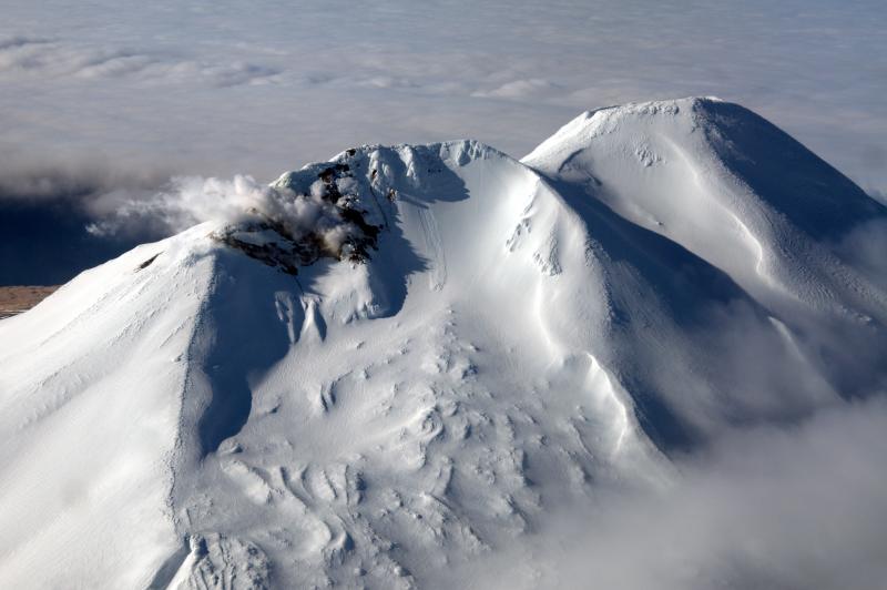
Summit vent on Gareloi Volcano.
Remarks:
Mount Gareloi, which makes up all of Gareloi Island, is a stratovolcano located in the Delarof Islands group of the Aleutian Islands, about 2,000 km (1,242 mi) west-southwest of Anchorage and about 150 km (93 mi) west of Adak, the westernmost community in Alaska. This small volcano is 10 × 8 km (6.2 × 5.0 mi) in diameter at its base with two summits, separated by a narrow saddle. The northern, slightly higher peak contains crater about 300 m (1,000 ft) across. The southern summit has a crater open to the south and a persistent degassing vent (fumarole) on its western rim. Gareloi has been one of the most active in the Aleutians since the 1740s, with 16 reports of eruptive activity at Gareloi since 1760. In 1929, its largest historical eruption produced sixteen small south- to southeast-trending craters that extend from the southern summit to the coast, as well as lava flows and pyroclastic deposits on the southeastern flank of the volcano. Eruptions of Gareloi commonly produce ash clouds and lava flows, and the primary hazard is airborne clouds of ash that could affect aircraft. Since seismic instruments were installed in 2003, they have detected small but consistent seismic signals from beneath Mount Gareloi’s edifice.
Source : AVO.
Photo : Ketner, Dane , Read, Cyrus / USGS-AVO.
Chile , Nevados de Chillan :
Seismicity parameters associated with rigid material fracturing (VT) processes showed a slight decrease in quantity, maintaining energy levels similar to those of the previous period. Fluid dynamics activity (LP and EX) showed an increase in the number of events and the energy emitted. Likewise, very long period events (VLP) and tremor pulses (TR) with higher energy and number than in the previous period were recorded.
The highest energy VT event, with a local magnitude (ML) of 2.6, was located 4.7 km east-southeast (ESE) of the active crater and at a depth of 4.2 km.
From the analysis of the images provided by the surveillance cameras belonging to OVDAS as well as the satellite images, an almost zero forward speed could be deduced for the lava flow called L5 with an estimated range of 966 m. Due to the growth of the fissure that feeds it, it was possible to distinguish the enhancement of secondary flows and the overlap of pre-existing morphologies. No growth of the dome nestled in the crater is observed, but partial destruction is noted. The lava flow called L6, which is advancing at a speed of 1.16 m / h has a range of 894 m.
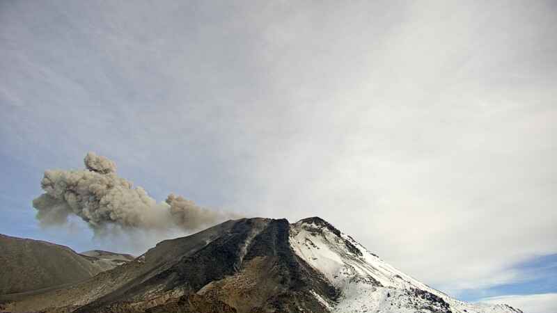
The explosive activity exhibited maximum column heights of less than 1400 m, with recurring particulate matter content. In turn, the high level of intensity, distribution and frequency of incandescent events associated with explosions, ballistics, spatter and landslides of lava flows concentrated on the east (E) of the crater and the East, South-East and North-East slopes to a lesser extent is maintained. The explosions occasionally generated proximal pyroclastic flows with a maximum extension of 1.1 km northeast of the volcanic edifice.
According to data obtained from the network of GNSS stations installed on the volcano, a change was observed in the vertical components of the stations located on the volcanic building, indicating a deflation with a maximum of -0.51 cm / month. Likewise, inter-station monitoring baselines suggest deflation that could be the result of material being ejected to the surface.
Thirty-six (36) thermal alerts were recorded in the area with a maximum value of 86 MW on May 23, considered moderate for this volcano. In turn, radiance anomalies were detected on May 20, 23, 25, 28 and 30 from Sentinel 2-L2A image analysis.
There is a rising trend in surface temperatures, which could be associated with the release of the new L6 lava flow. An increase in the temperature of the two streams, L5 and L6, is noticeable during May 25.
Source et photo : Segemar.