October 01 , 2023.
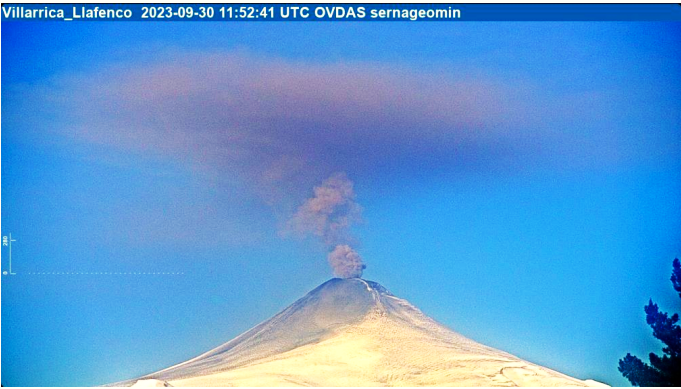
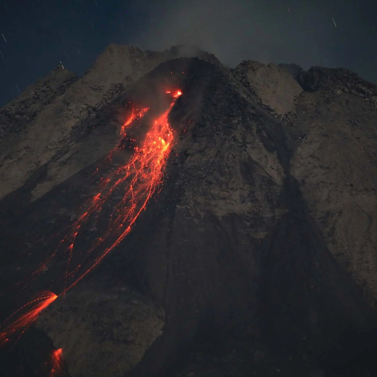
Chile , Villarica :
Special Report on Volcanic Activity (REAV), La Araucanía and Los Ríos regions, Villarrica volcano, September 30, 2023, 9:30 a.m. local time (mainland Chile)
The National Geology and Mining Service of Chile (Sernageomin) announces the following PRELIMINARY information, obtained through the monitoring equipment of the National Volcanic Monitoring Network (RNVV), processed and analyzed at the Southern Andean Volcano Observatory (Ovdas):
On Saturday September 30, 2023, surveillance cameras installed near the Villarrica volcano recorded an increase in the height of the degassing column and emissions of pyroclastic materials into the atmosphere (07:40 HL), reaching values of 500m above the level of the crater, with dispersion up to an altitude of 1100 m towards the North-Northwest. The grayish color of the surface activity highlights a high content of pyroclastic materials which, for the moment, are emitted in pulsatile form.
During this period, seismic activity is maintained with an RSAM value (average value of seismic energy) of 1.1µm/s, with permanent recording of long period type events, and low recording of signals. infrasound.
At the time of issuing this report, the activity described above is continuing.
The volcanic technical alert is maintained at ORANGE level.
Source et photo : Sernageomin.
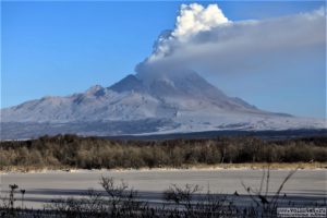
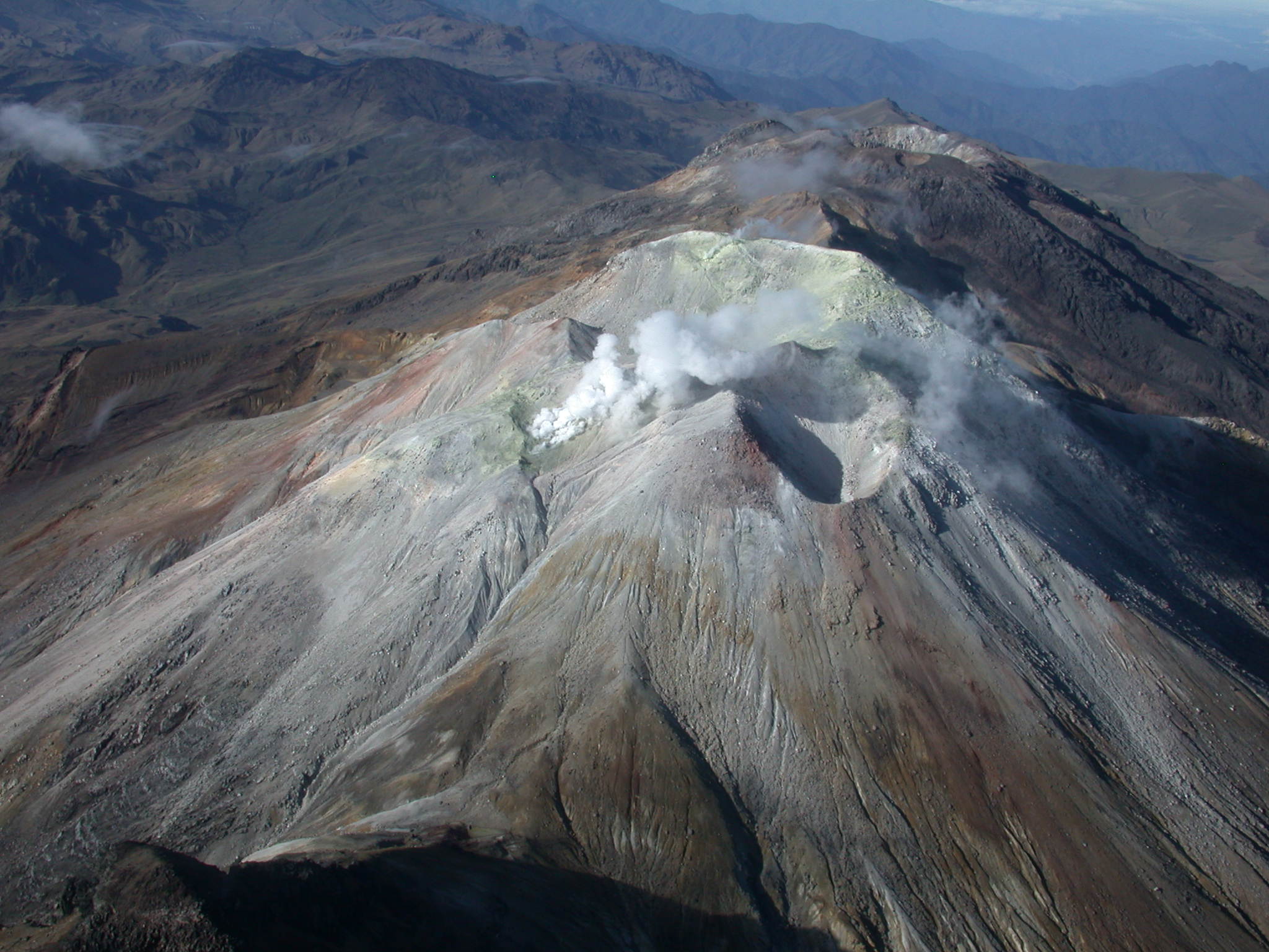
Indonesia , Merapi :
Report on the activity of Mount Merapi from September 22, 2023 to September 28, Published on September 29, 2023.
OBSERVATION RESULTS
Visual
The weather around Mount Merapi is generally sunny in the morning and afternoon, while the evening is foggy. White smoke, fine to thick, low to medium pressure and 100 m high was observed from the observation post of Mount Merapi de Selo on September 28, 2023 at 11:30 a.m.
This week, lava avalanches were observed 171 times towards the South and South-West, including 1 time upstream of the Gendol River up to a maximum of 600 m, 13 times upstream of the Boyong River up to 1500 m, 155 times upstream of the Bebeng River up to a maximum of 2000 m and 2 times upstream of the Sat/Putih River up to a maximum of 1600 m. The sound of avalanches was heard 15 times from the Babadan post with low to moderate intensity.
The morphology of the South-West dome has undergone changes observed by drone aerial photos on September 28, 2023 and analysis of thermal photos of the summit on September 27, 2023, showed the addition of material in the lava dome. The southwest dome morphology observed a slight increase in dome height as well as changes due to lava avalanche activity. During this time, no significant changes were observed for the central dome. On the central dome, the temperature of the dome is not much different from that of the surrounding rocks. The highest hotspot reached 236 degrees Celsius. There are no new magma extrusion points in either the southwest dome or the central dome. Based on the analysis of aerial photos from September 28, 2023, the volume of the southwest dome was measured at 3,097,700 cubic meters and that of the central dome at 2,358,500 cubic meters.
Hot spots were also observed in the lava flow towards Kali Boyong and Kali Krasak.
Seismicity
This week, the seismicity of Mount Merapi showed:
33 shallow volcanic earthquakes (VTB),
3866 multi-phase (MP) earthquakes,
4 low frequency (LF) earthquakes,
944 avalanche earthquakes (RF)
9 tectonic earthquakes (TT).
The intensity of seismicity this week is lower than last week, but the number of earthquakes is still quite high.
Deformation
The deformation of Mount Merapi that was monitored using EDM this week showed a shortening of steepening distance by 0.5 cm/day.
Rain and lahars:
There was no rain this week at Pengamatan’s Mount Merapi lookout post. There have been no reports of additional flows or lahars from rivers flowing down from Mount Merapi.
Conclusion
Based on the results of visual and instrumental observations, it is concluded that:
-Mount Merapi’s volcanic activity is still quite high in the form of effusive eruption activity. The activity status is defined at the “SIAGA” level.
The current danger potential is in the form of lava avalanches and hot clouds in the South-South-West sector including the Boyong river for a maximum of 5 km, the Bedog, Krasak, Bebeng rivers for a maximum of 7 km. In the South-East sector, it includes the Woro river for a maximum of 3 km and the Gendol river for 5 km. While the ejection of volcanic material in the event of an explosive eruption can reach a radius of 3 km from the summit.
Source : BPPTKG
Photo : Andi Volcanist
Colombia , Cumbal :
Weekly activity bulletin from the Cumbal Volcanic Complex
Regarding the monitoring of the activity of the CUMBAL VOLCANIC COMPLEX (CVC), the MINISTRY OF MINES AND ENERGY, through the COLOMBIAN GEOLOGICAL SERVICE (SGC), reports that:
During the period September 19-25, 2023, seismic activity, in terms of occurrence and energy released, maintained low and fluctuating levels similar to those reported in the immediately preceding weeks. The predominance of events related to rock fracturing within the volcanic edifice continued. This type of seismicity was located very close to the top of the CVC, with shallow depths and magnitudes less than 0.6.
White gas columns were recorded, with variable height and dispersion due to wind speed and direction, emissions originating mainly from the fumarole fields located to the Northeast of the CVC (El Verde, Humeros-Fogones and La Rea), as well as other fumarole fields located southwest of the CVC (La Banda, Rastrojos and Boca Vieja). No significant variation was observed in the other geophysical parameters of volcanic monitoring.
The state of alert for volcanic activity remains at:
YELLOW ALERT: Active volcano with changes in the behavior of the base level of monitored parameters and other manifestations
The COLOMBIAN GEOLOGICAL SERVICE remains attentive to the evolution of the volcanic phenomenon and will continue to report the changes observed in a timely manner.
Source et photo : SGC
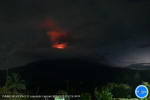
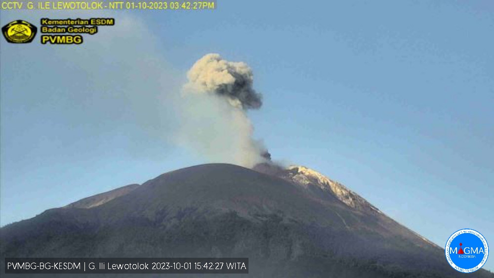
Indonesia , Ili Lewotolok :
An eruption of Mount Ili Lewotolok occurred on Sunday, October 1, 2023 at 3:38 p.m. WITA with the height of the ash column observed at ±500 m above the summit (±1923 m above sea level). The ash column was observed to be white to gray in color with thick intensity, oriented towards the West. This eruption was recorded on a seismograph with a maximum amplitude of 33.5 mm and a duration of 52 seconds.
VOLCANO OBSERVATORY NOTICE FOR AVIATION – VONA
Issued : October 01 , 2023.
Volcano : Ili Lewotolok (264230)
Current Aviation Colour Code : ORANGE
Previous Aviation Colour Code : orange
Source : Ili Lewotolok Volcano Observatory
Notice Number : 2023LEW063
Volcano Location : S 08 deg 16 min 19 sec E 123 deg 30 min 18 sec
Area : East Nusa Tenggara, Indonesia
Summit Elevation : 4554 FT (1423 M)
Volcanic Activity Summary :
Eruption with volcanic ash cloud at 07h38 UTC (15h38 local).
Volcanic Cloud Height :
Best estimate of ash-cloud top is around 6154 FT (1923 M) above sea level or 1600 FT (500 M) above summit. May be higher than what can be observed clearly. Source of height data: ground observer.
Other Volcanic Cloud Information :
Ash cloud moving to west. Volcanic ash is observed to be white to gray. The intensity of volcanic ash is observed to be thick.
Remarks :
Eruption recorded on seismogram with maximum amplitude 33.5 mm and maximum duration 52 second.
Source et photo : Magma Indonésie.
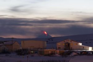
Mexico , Popocatepetl :
September 28, 11:00 a.m. (September 28, 5:00 p.m. GMT)
Activity from the last 24 hours
354 exhalations were detected, accompanied by water vapor, volcanic gases and slight amounts of ash. Additionally, 33 minutes of low-amplitude high-frequency tremors were identified.
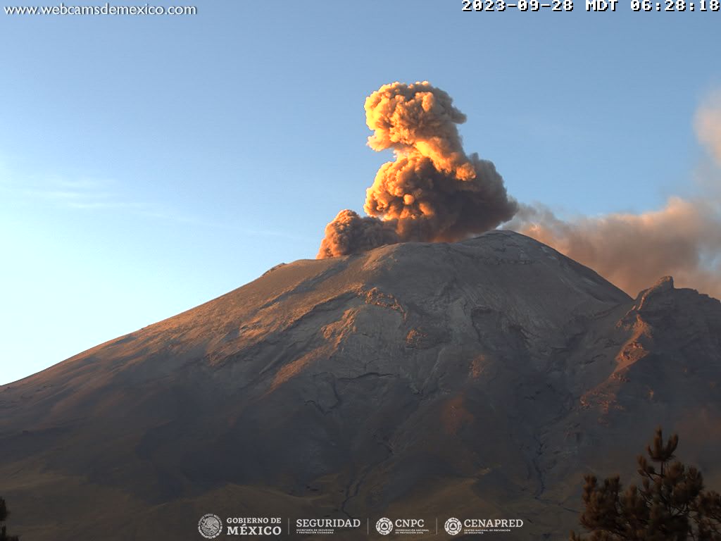
Derived from the activity of the volcano, today at 09:40 (local time), the National Center for Communication and Civil Protection Operations (Cenacom) reported an ash fall in the municipality of Tetela del Volcán, Morelos.
During the morning and at the time of this report, a continuous emission of water vapor and volcanic gases is observed, with dispersion towards the South-West (SW).
The Popocatépetl volcanic warning fire is in yellow phase 2.
Source et photo : Cenapred.