July 16 , 2023.
Alaska : Shishaldin
54°45’19 » N 163°58’16 » W,
Summit Elevation 9373 ft (2857 m)
Current Volcano Alert Level: WATCH
Current Aviation Color Code: ORANGE
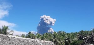
Shishaldin Volcano began erupting this week between July 11–12 and activity has increased resulting in ash clouds starting early on July 14.
A significant explosion occurred at 1:09 am AKDT (9:09 UTC) this morning and produced an ash cloud that initially reached 30,000 to 40,000 ft (9–12 km) above sea level and drifted south over the Pacific Ocean. A second smaller explosion occurred at 7:10 am AKDT (15:10 UTC) and reached ~15,000 ft (4.5 km) above sea level. The National Weather Service issued a SIGMET for these events and suggested a maximum cloud height of 25,000 ft (7.6 km) above sea level for the drifting ash cloud. Web camera images and pilot reports show continued low-level ash emissions this morning including a small ash cloud near the summit around 10:30 am AKDT (18:30 UTC ).
Observatory web camera images as well as photographs taken from a ship southwest of Unimak Island around 7:00 am AKDT (15:00 UTC) show small mudflow deposits generated by the interaction of hot pyroclastic material and snow and ice and as well as ashfall deposits on the southwest and north flanks of the volcano. Photographs also captured the 7:10 am event .
Earlier in the week the Aviation Color Code was raised to Yellow and the Volcano Alert Level to Advisory on Tuesday, July 11 following the observation of strongly elevated surface temperatures at the summit in satellite data and tremor in seismic data. Strongly elevated surface temperatures continued to be observed in satellite data on Wednesday, July 12 and seismic tremor amplitudes increased. In addition, sulfur dioxide was detected in satellite data and incandescence was observed at the summit in web camera images suggesting that lava was likely being erupted in the summit crater. In response, the Aviation Color Code was raised to Orange and Volcano Alert Level to Watch on Wednesday July 12. Observations from a US Coast Guard overflight the same day confirmed that lava was erupting within the summit crater .

Prior to the current activity, the 2019-2020 eruption of Shishaldin was the first to produce lava flows outside of the crater area since 1976. Minor eruptions in 2004 and 2014 produced lava flows that remained confined to the summit crater. Eruptions from Shishaldin have produced minor ash clouds in the past. These can occur with little warning. Satellite data is routinely monitored to look for ash clouds and seismic and infrasound (pressure sensor) data is watched for signs of any explosions that might produce ash clouds. In addition, ashfall forecast models are kept up to date on the public activity page that show both ash distribution and fallout to the ground if it were to occur given the current weather conditions.
The eruption of Shishaldin Volcano has intensified. An ash cloud to 15,000 ft (4.6 km) above sea level and drifting to the SSE has been observed in satellite data starting at about 9:00 pm AKDT (17:00 UTC) , July 15 , 2023 . The National Weather Service has issued a SIGMET for this activty. Seismic tremor amplitudes began to increase starting around 5:00 pm AKDT (1:00 UTC) and are continuing. The actvity has also been observed on regional infrasound (presure sensor) arrays.
Source : AVO.
Photos : Caudle, Blake , U.S. Coast Guard Air Station Kodiak 1999.
La Réunion , Piton de la Fournaise :
Press release from the Institut de physique du globe de Paris, Volcanological Observatory of Piton de la Fournaise. July 15, 2023 – 11:30 a.m. – 07:30 a.m. UTC
Ongoing eruption
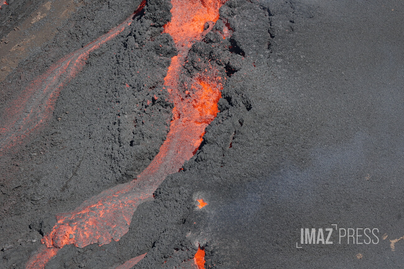
The eruption which began on July 02, 2023, around 08:30 local time continues. The amplitude of the volcanic tremor (indicator of an emission of lava and gas on the surface) is always fluctuating over time on the scale of a few tens of minutes, with phases of continuous tremor and phases of intermittent tremor. The amplitude of the tremor nevertheless remains low compared to the start of the eruption.
The fluctuations observed in the tremor are reflected at the level of the eruptive site by variations in intensity in the activity, with projections of lava fountains at the level of the more or less intense eruptive cone.
Given the bad weather conditions currently on site:
– no visual feedback on the eruptive site and the lava field could be made today and tonight,
– nor any estimate of lava flows by satellite method.
A slight deflation of the summit area is still recorded.
The seismic activity recorded under the summit zone remains weak. Thus over the last 24 hours, no superficial volcano-tectonic earthquake has been recorded. This low seismic activity leads to a reduction in the risk of the appearance of a new crack and/or collapse in the crater, but does not mean that it can be excluded.
Alert level: Alert 2-1 (eruption in the Enclosure without any particular threat to the safety of people, property or the environment).
Source : OVPF
Photo : RB/www.imazpress.com
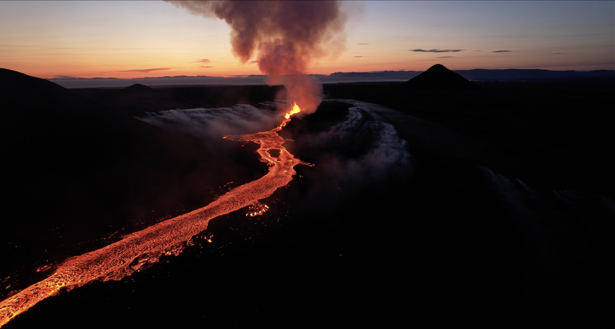
Iceland , Litli Hrútur :
July 15 , 2023. The eruption site remains closed.
The eruption site at Litli-Hrútur will remain closed. The decision was taken at this morning’s meeting of the Suðurnes Police Headquarters and the ICE-SAR Landsbjörg.
Police chief Úlfar Lúðvíksson told the newsroom that conditions had not improved enough to allow entry.
« We reached the conclusion that the eruption site will remain closed. The weather conditions are the same as yesterday. Firefighters must attempt to control the spreading wildfires, and rescuers will use the day to build a hiking trail. The situation is basically the same as yesterday, therefore the area remains closed. »
When will the decision be reconsidered?
« The decision will be reviewed at tomorrow’s 9am meeting. »
The Met Office’s new gas measuring device should give a better overall picture of the eruption. Scientists worked late into the night at the site yesterday.
Benedikt Ófeigsson, a geophysicist, is one of the two scientists who went on the expedition last night. He says that two types of gas meters are used to monitor the gas stations. Last night, they were installing so-called DOS meters, which are set to assess the total flow of sulphur pollution from the entire eruption. It helps to tell what magma is coming up and gives a better overall picture of the eruption.
Source : RUV.
Photo : RÚV – Kristján Þór Ingvarsson
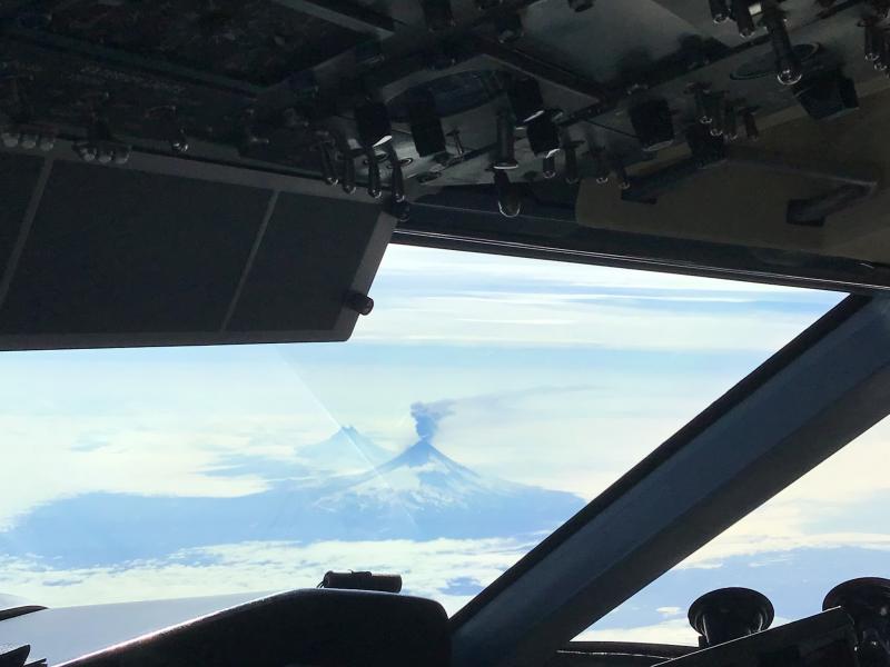
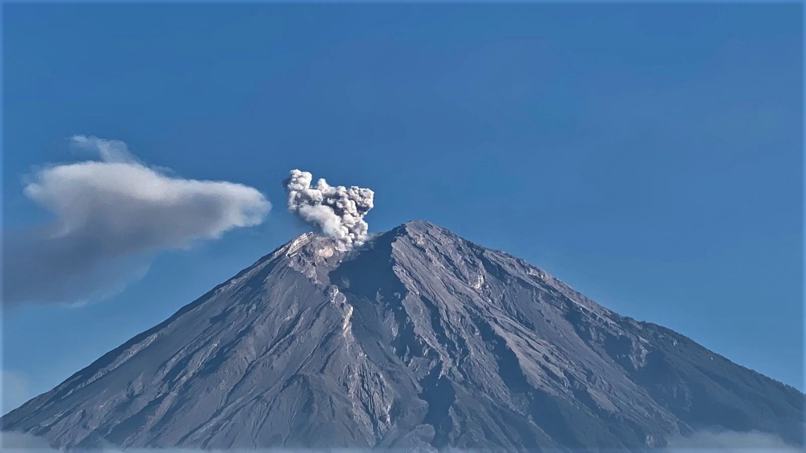
Indonesia , Semeru :
An eruption of Mount Semeru occurred on Friday, July 14, 2023 at 3:08 p.m. WIB. The height of the eruption column was not observed. The eruption was recorded on a seismograph with a maximum amplitude of 22 mm and a duration of 110 seconds.
VOLCANO OBSERVATORY NOTICE FOR AVIATION – VONA
Issued : July 14 , 2023
Volcano : Semeru (263300)
Current Aviation Colour Code : ORANGE
Previous Aviation Colour Code : orange
Source : Semeru Volcano Observatory
Notice Number : 2023SMR226
Volcano Location : S 08 deg 06 min 29 sec E 112 deg 55 min 12 sec
Area : East java, Indonesia
Summit Elevation : 11763 FT (3676 M)
Volcanic Activity Summary :
Eruption with volcanic ash cloud at 08h08 UTC (15h08 local).
Volcanic Cloud Height :
Best estimate of ash-cloud top is around 14003 FT (4376 M) above sea level or 2240 FT (700 M) above summit. May be higher than what can be observed clearly. Source of height data: ground observer.
Other Volcanic Cloud Information :
Ash cloud moving to southwest. Volcanic ash is observed to be white to gray. The intensity of volcanic ash is observed to be thick.
Remarks :
Eruption recorded on seismogram with maximum amplitude 22 mm and maximum duration 110 second.
Source : Magma Indonésie.
Photo : Andi Volcanist.
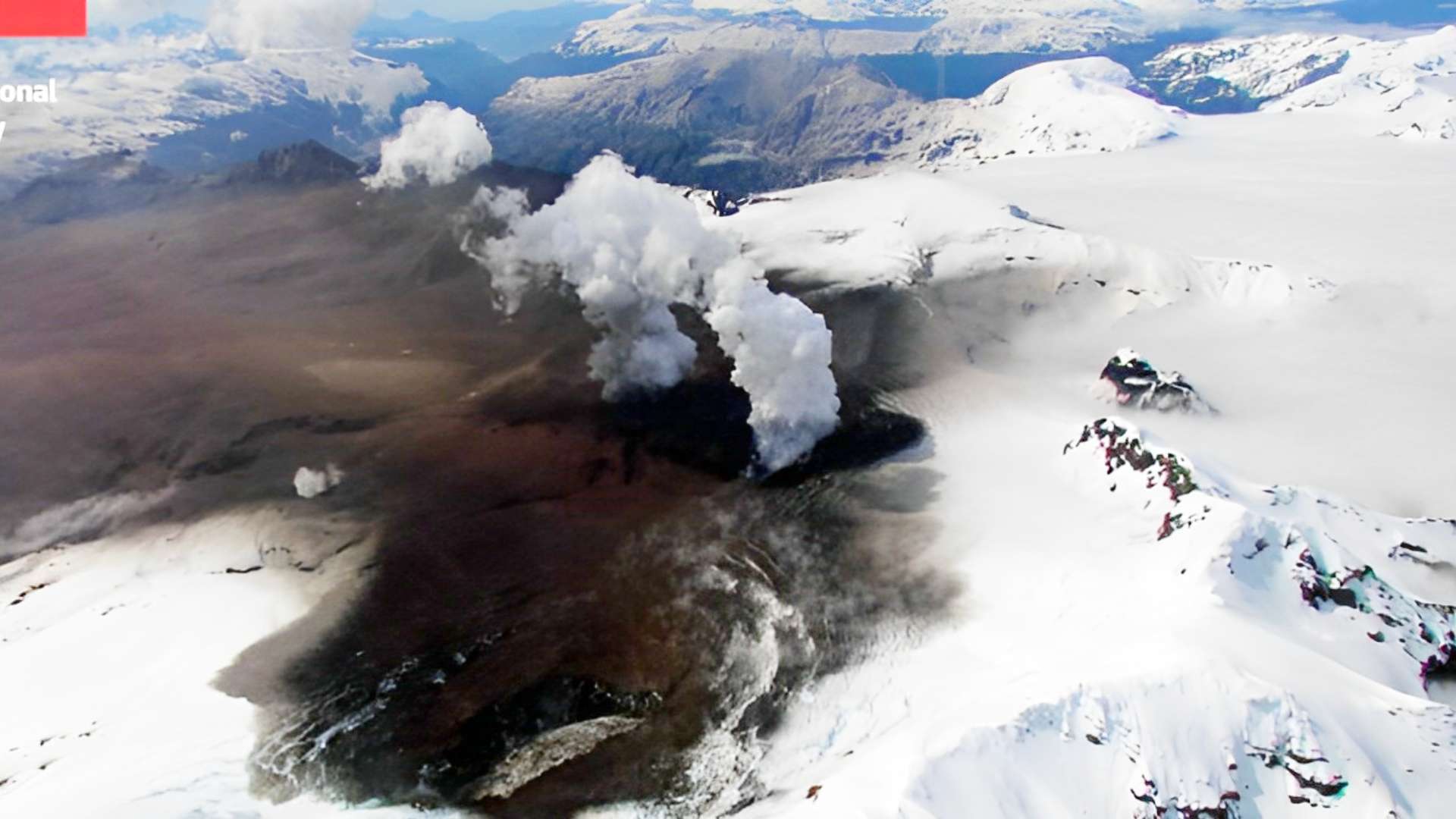
Chile , Hudson :
Special Report on Volcanic Activity (REAV), Aysen Del General Carlos Ibanez Del Campo Area, Hudson Volcano, July 14, 2023, 5:25 p.m. local time (mainland Chile).
The National Service of Geology and Mines of Chile (Sernageomin) publishes the following PRELIMINARY information, obtained through the monitoring equipment of the National Volcanic Monitoring Network (RNVV), processed and analyzed at the Volcanological Observatory of the Southern Andes ( Ovdas):
On Friday July 14, 2023, at 4:44 p.m. local time (20:44 UTC), the monitoring stations installed near the Hudson volcano recorded an earthquake associated with both rock fracturing (volcano-tectonic type) and fluid dynamics in the volcanic system (hybrid type).
The characteristics of earthquakes after their analysis are as follows:
ORIGINAL TIME: 4:44 p.m. local time (8:44 p.m. UTC)
LATITUDE: 45.943°S
LONGITUDE: 72.843°E
DEPTH: 25.7 km
LOCAL MAGNITUDE: 2.9
REDUCED DISPLAY: 885 cm2
COMMENTS:
Following the event, no other similar events were recorded, nor changes in the seismic behavior of the volcano. .
The volcanic technical alert remains at the Green level.
Sources : Sernageomin.
Photo : Meganoticias