July 12 , 2023.
Iceland : Reykjanes Peninsula :
Minor volcanic eruption on the Reykjanes Peninula
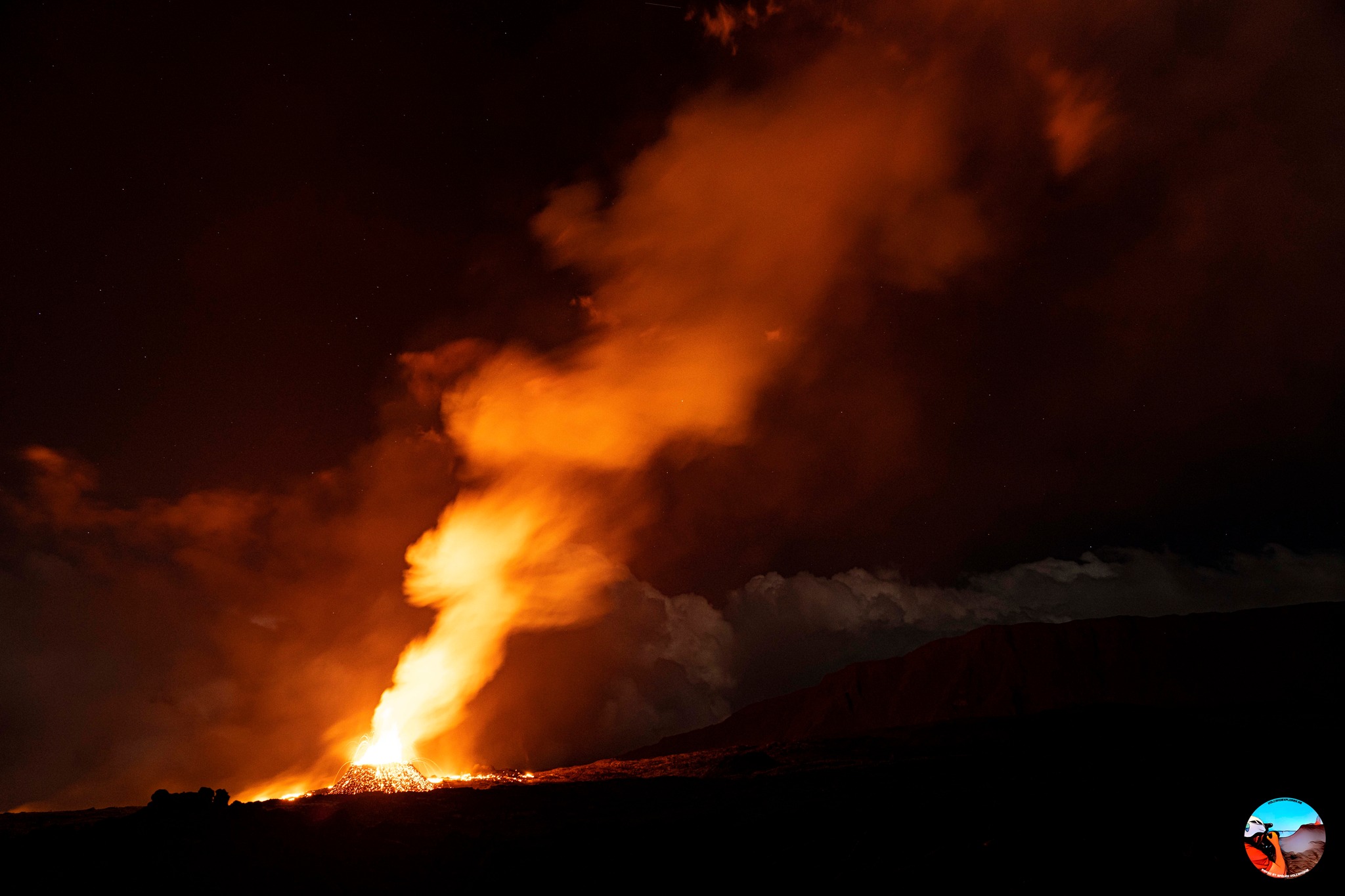
The intensity of the eruption by Litli-Hrútur mountain on Reykjanes has decreased dramatically
Updated 11. July 2023 at 12:50pm
Key points:
A lava-producing fissure eruption is occurring close to Litli-Hrútur mountain on the Reykjanes Peninsula.
The eruption is occurring in an uninhabited area and it poses no immediate dangers to infrastructure.
The intensity of the eruption has decreased considerably during the first 24 hours
Volcanic ash is not being produced by the eruption.
Close to the eruption, the main hazards are incandescent, flowing lava and volcanic gases.
Gas measurements at the eruption site during the first hours show levels similar to the 2022 eruption.
Flowing lava could also cause localised grass fires, which will further contribute to poor air quality close to the eruption site.
New data shows that the magma intrusion reaches under Keilir with deformation on the surface between Litli-Hrútur and Keilir. Highest likelihood of new eruption vents, should they open, is however still at Litli-Hrútur.

The intensity of the eruption by Litli-Hrútur mountain on Reykjanes has decreased dramatically since it started on 16:40 Monday 10 July 2023 with fewer and lower lava fountains compared to at the start. The seismic tremor (ground noise) due to the eruption reached a peak between 21:00 UTC and midnight Monday 10 July and has shown a steady decline between midnight to 11 on Tuesday 11 July. The most likely reason is the reported decrease in effusive rates of magma and gases and lava outflow concentrating on fewer vents.
New ICEYE interferogram covering the period from 9 to 10 July 2023 shows that the deformation related to the dike intrusion between Fagradalsfjall and Keilir had progressed approximately 1 km further northeast (compared to Saturday 8 July), reaching under Keilir mountain. Moreover, it shows narrowing of bounding faults of the dike in the vicinity of the eruptive fissure that formed at the eastern base of Litli-Hrútur mountain and northeast of it between Litli-Hrútur and Keilir. This is the same location as the dike intrusion, as inferred from earlier modeling.
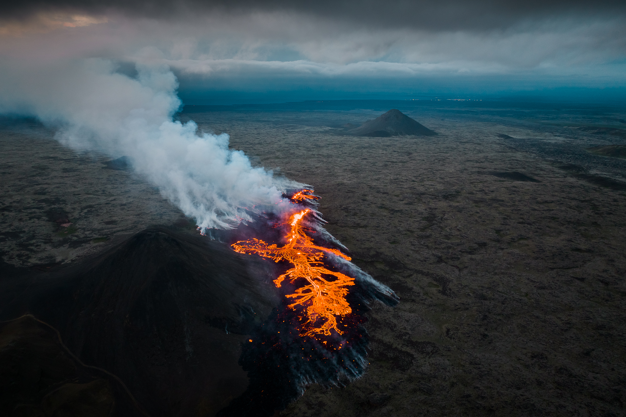
The lava flow is currently mostly channeled to the southeast and into a shallow valley south of Litli-Hrútur that will most likely fill in a short time and continue towards south. Lava may potentially also likely flow towards southeast of a small ridge at the edge of the shallow valley. From there likely flow paths are towards the south and around the ridge. Currently the lava is not flowing westward and northward from the eruption site. Should lava continue to flow southwards it is expected to eventually flow into and over the 2022 Merardalir lava flow.
Consistent with observations from the 2021 and 2022 intrusions, GPS measurements further away now show very little deformation, and seismicity in the region has decreased substantially. Earthquake activity today is almost exclusively concentrated around Keilir and towards Kleifarvatn, where most triggered earthquake activity was observed during last week’s dike intrusion. However, just before the eruption, small earthquakes at very shallow depths had been detected under Litli-Hrútur.

It is important to note that in the vicinity of the eruptive fissures and lava field the conditions can change quickly. We advise people from staying at the eruption site due to the following key hazards:
Sustained and localized gas pollution that increases when winds are lower. Dangerous and potentially fatal gas levels may accumulate in lows
Lava can ignite vegetation fires that dramatically can decrease air quality at the site
New eruption fissures may open near the existing vents without very little notice
Chunks of lava may fall from the lava´s edge along with sudden advances of new lava from and over the edge at speeds that one may potentially not outrun.
Source : IMO.
Photos : Garðar Ólafsson , Almannavarnadeild ríkislögreglustjóra .
La Réunion , Piton de la Fournaise :
Press release from the Paris Institute of Earth Physics / Piton de la Fournaise Volcanological Observatory. July 11, 2023 – 1:00 p.m. – 9:00 a.m. UTC.
Ongoing eruption
The eruption which began on July 02, 2023, around 08:30 local time continues. The amplitude of the volcanic tremor (indicator of an emission of lava and gas on the surface) fluctuates over time on the scale of a few hours with phases of continuous tremor and phases of intermittent tremor. Yesterday at midday, the amplitude of the tremor increased, then stabilized at a level 2 times higher than the previous days. However, it remains weak compared to the beginning of the eruption. This is reflected at the level of the eruptive site by fluctuations in activity, with projections of lava fountains at the level of the more or less intense eruptive cone.
Lava flow estimates established by satellite method on the HOTVOLC platform (OPGC – Clermont Auvergne University) over the past 24 hours indicated flows between 0.5 and 8 m3 / sec. Given the cloud mass present regularly on the eruptive site as well as the presence of lava tunnels, these flows may be underestimated. The total volume of lava emitted since the start of the eruption is estimated at 5.5 Mm3 by the HOTVOLC platform (OPGC – Clermont Auvergne University).
The active volcanic cone – located southeast of the Enclos Fouqué at an altitude of 1720 m – continues to build by accumulating lava projections.
The flow of the lava now takes place partly in a lava tunnel in the immediate vicinity of the cone under construction, even if flows are still visible. Last night the active flows were still at altitudes above 1300 m at the top of the Grandes Pentes.
The flow front has not changed since July 5 and is still 1.8 km from the road.
At present, no significant deformation of the building is recorded.
Seismic activity is still recorded under the summit area but it remains weak compared to the start of the eruption. Thus over the last 24 hours, 2 superficial volcano-tectonic earthquakes have been recorded. This reduction leads to a reduction in the risk of the appearance of a new crack and/or collapse in the crater, but does not mean that it can be excluded.
Alert level: Alert 2-1 (eruption in the Enclos without any particular threat to the safety of people, property or the environment).
Source : OVPF
Photo : Volcanoexplorer.re Tunnels de lave Réunion / Vincent Cheville.
Italy / Sicily , Etna :
WEEKLY BULLETIN from July 03, 2023 to July 09, 2023. (issue date July 11, 2023)
ACTIVITY STATUS SUMMARY
In the light of the monitoring data, it is highlighted:
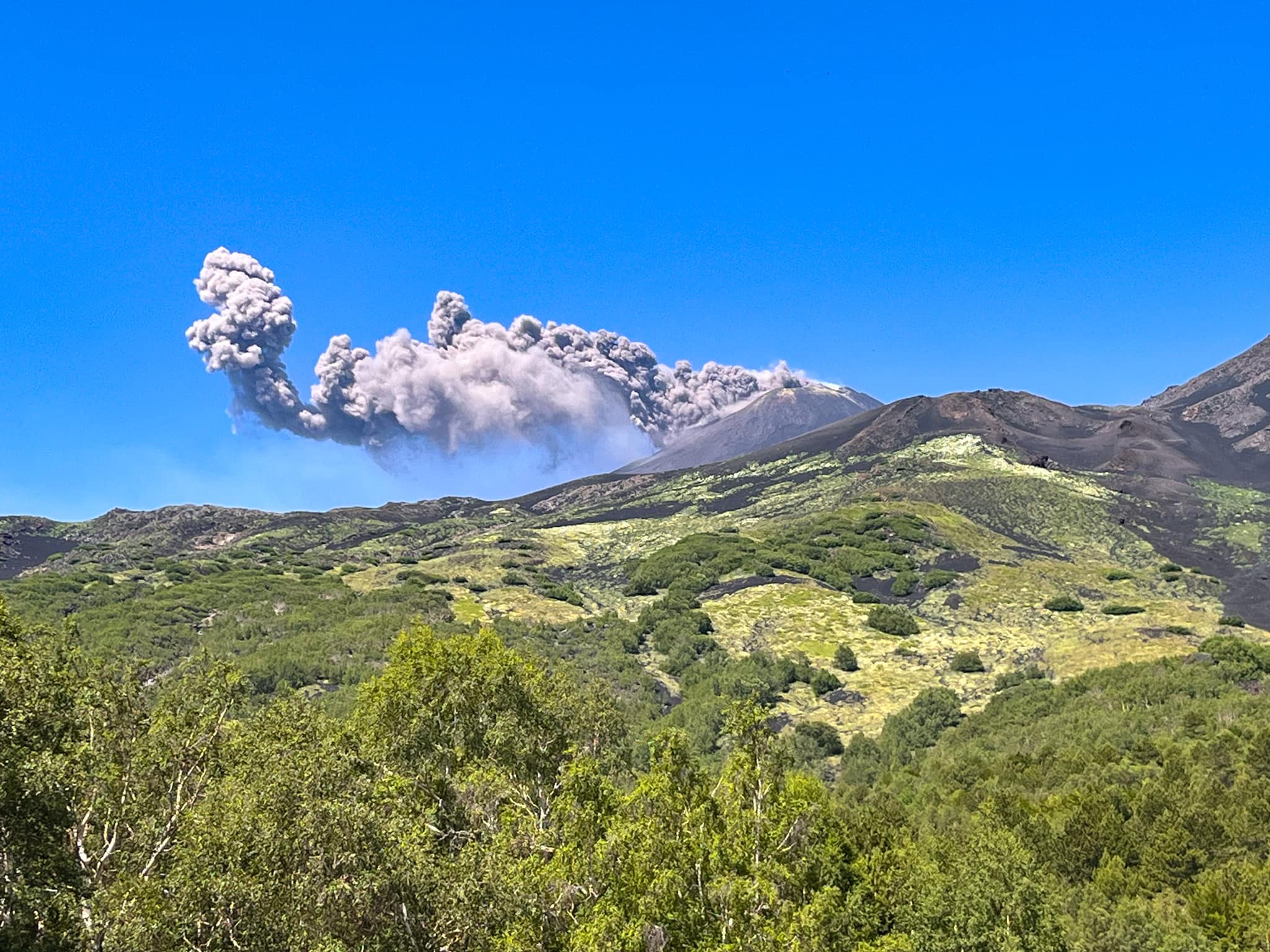
1) VOLCANOLOGICAL OBSERVATIONS: Degassing activity at the summit craters, in particular continuous degassing at the Southeast crater (CSE) and at the Bocca Nuova crater (BN).
Sporadic and weak ash emissions from the Southeast crater.
2) SEISMOLOGY: The seismicity of the week was characterized by the appearance of a seismic sequence located a few kilometers from the town of Cesarò; the amplitude of the volcanic tremor has fallen back into the middle range; the location of the center of gravity of the sources of volcanic tremors was stable in the area of the Southeast crater.
3) INFRASOUND: Average activity level: the moderate increase observed the previous week continues with sources located at the Bocca Nuova and Southeast craters.
4) GROUND DEFORMATIONS: Over the past week, ground deformation monitoring networks have not recorded any significant changes
5) GEOCHEMISTRY: SO2 flux at an average level The CO2 fluxes show a downward trend settling on average degassing values.
The isotopic ratio of Helium is at high levels.
The partial pressure of dissolved CO2 does not show any significant variations.
6) SATELLITE OBSERVATIONS: Thermal activity observed from the satellite was generally weak.
VOLCANOLOGICAL OBSERVATIONS
During the week, the monitoring of Etna’s activity was carried out through the network of surveillance cameras of the INGV – Osservatorio Etneo.
The week was characterized by the degassing of the summit craters, mainly at the level of the Southeast crater (SEC), at the level of the Bocca Nuova crater (BN).
On July 9, the Southeast crater resumed explosive activity with the emission of ash, which quickly dispersed in the summit area. This activity was repeated on the following days with varying frequency and intensity.
Source : INGV
Photo : EtNative – to explore Mount Etna.
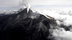
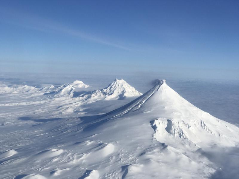
Alaska , Shishaldin :
AVO/USGS Volcanic Activity Notice
Current Volcano Alert Level: ADVISORY
Previous Volcano Alert Level: NORMAL
Current Aviation Color Code: YELLOW
Previous Aviation Color Code: GREEN
Issued: Tuesday, July 11, 2023, 2:39 PM AKDT
Source: Alaska Volcano Observatory
Notice Number: 2023/A1034
Location: N 54 deg 45 min W 163 deg 58 min
Elevation: 9373 ft (2857 m)
Area: Aleutians
Volcanic Activity Summary:
Strongly elevated surface temperatures at the summit of Shishaldin Volcano have been observed in satellite data over the past day. Intermittent tremor and low-frequency earthquakes over the past week have gradually become more regular and consistent in the past day. In response, the Alaska Volcano Observatory is raising the Aviation Color Code to YELLOW and the Alert Level to ADVISORY. These observations represent a departure from normal background activity at Shishaldin, but do not necessarily indicate that an eruption will occur
.
Shishaldin is monitored by local seismic and infrasound sensors, web cameras, and a telemetered geodetic network. The local monitoring network is partially impaired, therefore AVO is also using nearby geophysical networks, satellite data and regional infrasound and lighting data to detect activity. AVO will continue to closely monitor unrest at Shishaldin Volcano.
Remarks:
Shishaldin Volcano, located near the center of Unimak Island in the eastern Aleutian Islands, is a spectacular symmetric cone with a base diameter of approximately 16 km (10 mi). A 200-m-wide (660 ft) funnel-shaped summit crater typically emits a steam plume and occasional small amounts of ash. Shishaldin is one of the most active volcanoes in the Aleutian volcanic arc, with at least 54 episodes of unrest including over 26 confirmed eruptions since 1824. Most eruptions are relatively small, although the April-May 1999 event generated an ash column that reached 45,000 ft above sea level.
Source : AVO
Photo : Jacob, Ben David
Indonesia , Ili Lewotolok :
An eruption of G. Ili Lewotolok occurred on Tuesday, July 11, 2023 at 2:59 p.m. WITA with the height of the ash column observed at ± 400 m above the summit (± 1823 m above sea level) . The ash column was observed to be gray with light to moderate intensity, oriented to the west. This eruption was recorded on a seismograph with a maximum amplitude of 23.2 mm and a duration of 59 seconds.
VOLCANO OBSERVATORY NOTICE FOR AVIATION – VONA
Issued : July 11 , 2023 .
Volcano : Ili Lewotolok (264230)
Current Aviation Colour Code : ORANGE
Previous Aviation Colour Code : orange
Source : Ili Lewotolok Volcano Observatory
Notice Number : 2023LEW040
Volcano Location : S 08 deg 16 min 19 sec E 123 deg 30 min 18 sec
Area : East Nusa Tenggara, Indonesia
Summit Elevation : 4554 FT (1423 M)

Volcanic Activity Summary :
Eruption with volcanic ash cloud at 06h59 UTC (14h59 local).
Volcanic Cloud Height :
Best estimate of ash-cloud top is around 5834 FT (1823 M) above sea level or 1280 FT (400 M) above summit. May be higher than what can be observed clearly. Source of height data: ground observer.
Other Volcanic Cloud Information :
Ash cloud moving to west. Volcanic ash is observed to be gray. The intensity of volcanic ash is observed from thin to medium.
Remarks :
Eruption recorded on seismogram with maximum amplitude 23.2 mm and maximum duration 59 second.
Source et photo : Magma Indonésie.